You’ll find approximately eight documented ghost towns scattered across New Hampshire, though the exact count varies depending on how abandonment’s defined—whether you’re counting completely vanished logging settlements, partially depopulated villages, or communities now submerged beneath reservoir waters. These sites range from colonial-era Monson Center, abandoned around 1770, to twentieth-century casualties like Old Hill Village, flooded in 1937 for dam construction. Foundation stones, cellar holes, and historical markers preserve evidence of communities lost to resource depletion, fires, floods, and economic shifts—each site revealing distinct chapters of New Hampshire’s settlement history.
Key Takeaways
- New Hampshire has approximately 8 documented ghost towns, though local folklore references more communities than official records capture.
- Notable ghost towns include Livermore, Monson, Old Hill Village, Zealand, and Kilkenny, each with distinct abandonment histories.
- Communities disappeared due to logging depletion, floods, fires, dam construction, and shifts in transportation and economic routes.
- Most ghost towns are in the White Mountains region, marked by foundation ruins, cellar holes, and colonial archaeological remains.
- The state maintains a systematic historical marker program identifying settlement sites like Monson Center, Zealand, and Willowdale.
The Official Count of Abandoned Settlements in New Hampshire
According to current state records, New Hampshire contains 8 documented ghost towns****—abandoned settlements that once functioned as vibrant communities with multiple inhabitants.
You’ll find the vast majority are barren sites marked only by foundation pits and building outlines, presenting significant preservation challenges for historians and archaeologists.
The definition varies by source, creating incomplete counts due to difficulty locating and documenting all abandoned settlements.
Local folklore often references more communities than official records confirm, reflecting the blurred line between documented ghost towns and defunct placenames scattered throughout New Hampshire’s history.
These eight settlements represent broader patterns of abandonment across New England, where economic shifts, natural disasters, and resource depletion gradually emptied once-thriving communities between the 1700s and mid-20th century. In contrast, neighboring states like Rhode Island have just 1 ghost town (Hanton City), while Vermont and Maine each contain five abandoned settlements, demonstrating New Hampshire’s intermediate position among New England ghost town concentrations. Historical documentation like Alonzo Fogg’s 1874 Gazetteer provides valuable statistical data about these former settlements and their original statuses.
Notable Ghost Towns and Their Stories
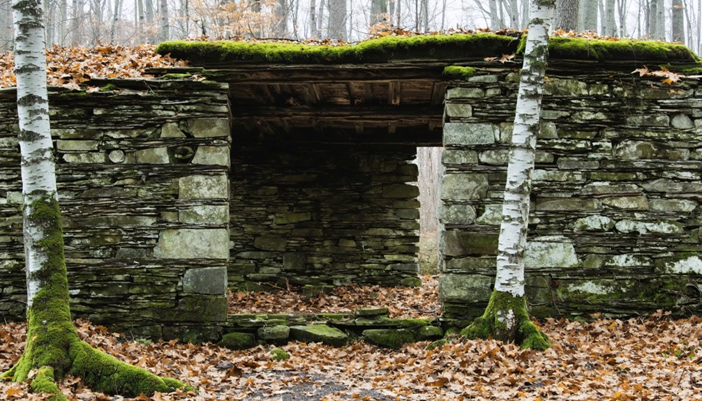
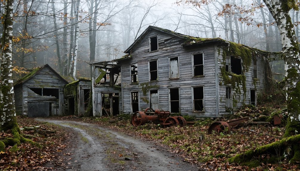
Each abandoned settlement across New Hampshire tells a distinct story of ambition, survival, and eventual decline, preserved through architectural remnants, historical markers, and archaeological evidence. Livermore, founded in 1876 as a logging operation in Northern Grafton County, exemplifies the volatile nature of single-industry towns—the Saunders family controlled the entire settlement, which housed under 200 residents alongside a mill, school, blacksmith shop, and store before fires and a devastating 1920s flood triggered depopulation. Today, visitors can observe stone foundations and brick structures marking where the school and homes once stood.
You’ll find Monson, settled in 1737, abandoned after just thirty years when residents voluntarily repealed their charter due to poor soil.
Old Hill Village faced federal seizure in 1937 for flood control, displacing an entire community. Construction of dams and reservoirs has historically flooded entire towns, forcing residents to relocate and creating submerged ghost towns throughout the state.
While haunted legends and wild stories circulate about these locations, the documented evidence reveals economic realities rather than supernatural causes drove populations away.
Why These Communities Disappeared
The collapse of New Hampshire’s ghost towns stemmed from interconnected economic and environmental pressures that overwhelmed small communities’ capacity to adapt. You’ll find these communities disappeared through:
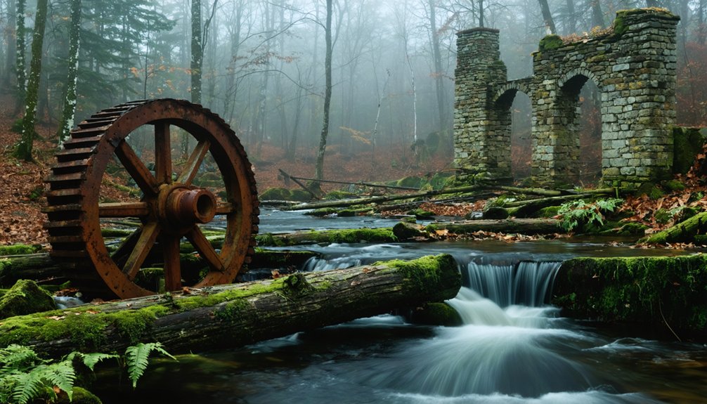
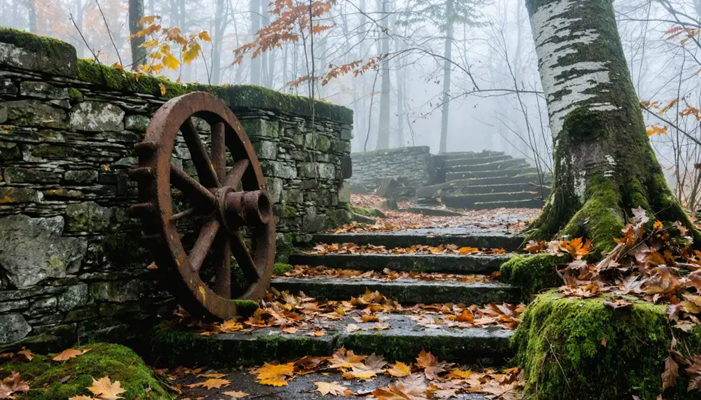
- Resource exhaustion – Timber depletion ended logging operations in Zealand, Livermore, and Kilkenny, leaving populations under 200 without viable economies.
- Natural disasters – The 1920s flood destroyed Livermore’s mill while fires repeatedly damaged structures, accelerating abandonment. A smallpox epidemic further weakened vulnerable settlements already struggling with economic decline. Repeated floods in 1875, 1916, 1936, 1938, and 1941 devastated Hill’s infrastructure before its final relocation.
- Infrastructure shifts – Railroad closures and improved transportation bypassed isolated villages like East Weare.
- Government intervention – Federal seizure in 1937 displaced Hill’s residents for Franklin Falls Dam.
Today, these abandoned sites serve dual purposes as wildlife habitats and historical preservation opportunities, offering you tangible connections to New Hampshire’s industrial past without government restrictions on exploration.
What Remains Today: Exploring the Ruins
While most of New Hampshire’s ghost towns left minimal traces, six sites preserve substantial architectural remnants that document the state’s abandoned settlements.
You’ll find Livermore’s brick power mill walls and concrete sawmill foundations alongside scattered domestic debris. Foundations of the schoolhouse remain visible from the road, marking where children once learned in this former logging community. Madame Sherri’s stone staircase stands among forest growth in Chesterfield, while Monson Center’s colonial structures offer 2.5 miles of explorable ruins.
Zealand Village and Thornton Gore present scattered homestead remains along hiking trails. Alternative folklore surrounds these sites—from ghostly laughter at Madame Sherri’s to curse claims at Zealand.
Old Hill Village presents unique preservation challenges, submerged beneath Franklin Falls Reservoir since 1941. These accessible ruins let you investigate New Hampshire’s settlement patterns independently, revealing construction methods and community layouts without bureaucratic restrictions.
The Isles of Shoals retain historical significance from the 1873 Smuttynose Murders, where two women were killed and the surviving victim escaped by hiding near what’s now known as Maren’s Rock.
Where to Find New Hampshire’s Ghost Towns
Locating New Hampshire’s ghost towns requires traversing the White Mountains region, where most abandoned settlements cluster along former logging corridors. You’ll find these sites along backcountry routes where environmental impact from 19th-century industry remains visible through stone foundations and overgrown pathways.
Key Access Points:
- Sawyer River Road: Leads to Livermore’s scattered artifacts near Lincoln and Woodstock.
- Monson Center dirt roads: Follow former West Road through 17,000 acres of cultural significance.
- Roadside pull-offs: Designated parking areas throughout forested zones.
- Walking trails: Navigate cellar holes and stone walls marking homestead boundaries.
White Mountain History maintains documentation of precise locations.
You’re free to explore these archaeological sites, though many require hiking through unmarked terrain where nature has reclaimed once-thriving communities. Texas has the highest number of ghost towns among all U.S. states, though New Hampshire’s sites offer unique New England archaeological value. Local historical societies can provide additional information about specific sites and their backstories.
As you venture into the mysteries of abandoned communities, keep an eye out for intriguing local legends, such as the ghost stories from Torras, Louisiana. These eerie tales can enrich your experience, adding a layer of intrigue to the history of the sites you visit. Each story is a testament to the lives once lived in these forgotten places, making the exploration all the more captivating.
Documenting and Preserving Forgotten Places
You’ll find that preserving ghost towns requires systematic documentation through archaeological surveys, historic structure reports, and photographic records that establish baseline conditions before sites deteriorate further.
Physical markers—interpretive signs at cellar holes, restored buildings serving as museums, and labeled foundation stones—transform invisible histories into tangible narratives accessible to the public.
Organizations like the Society for Protection of New Hampshire Forests and state preservation agencies maintain these records while coordinating field access, ensuring that archaeological evidence and genealogical connections survive for future research.
Historical Markers and Records
New Hampshire’s systematic documentation of ghost towns through its historical marker program provides essential evidence for understanding settlement patterns and economic shifts across the state.
You’ll find official markers designating locations like East Weare Village, Willowdale Settlement, Alderbrook, and Wildwood, each preserving site-specific historical data. The Zealand marker documents James Everell Henry’s lumber operations and their eventual collapse.
Primary documentation efforts include:
- Biographical markers at seven original Monson Center home sites with genealogical records
- Farmstead ruins marked with stone foundations at Gould, Wallingford, and Nevins homesteads
- Old Hill Village plaques identifying stores, depots, and hotels before 1941 relocation
- Needle Brook trailhead signs describing old mill foundations and cellar holes
These archival resources let you trace authentic settlement histories without government interference or restricted access to your heritage.
Archaeological Remains and Access
Beyond the markers themselves, physical evidence of these abandoned settlements remains accessible across New Hampshire’s landscape. You’ll find stone foundations, cellar holes, and rutted roadways at Monson’s 325 preserved acres—recognized by archaeologists as New England’s most significant colonial site.
Livermore’s scattered debris, including sawmill ruins and railroad bridge remnants, offers unmediated glimpses into logging-era life without formal archaeological excavation restrictions. Access varies by season and location: Old Hill Village opens to vehicles one weekend annually, while winter conditions invite snowmobiling and skiing.
These sites resist sanitized modern tourism, presenting raw historical evidence instead. Hand-drawn maps, exposed foundations, and overgrown pathways let you navigate these spaces independently, tracing the physical imprints communities left behind when economic realities forced their abandonment.
Frequently Asked Questions
Are New Hampshire Ghost Towns Safe to Visit Alone?
You’ll face real risks exploring New Hampshire’s ghost towns alone—flooding, limited access, and zero infrastructure. For urban exploration and historical preservation, you’re better off visiting with companions who can assist during emergencies in these remote locations.
Can I Legally Take Artifacts From Abandoned Ghost Town Sites?
You can’t legally take artifacts from New Hampshire’s ghost towns without permits. Legal restrictions under federal and state laws prohibit artifact collection from public lands, protecting historical resources. Even on seemingly abandoned sites, removal risks felony charges and substantial fines.
Do Any Ghost Towns Have Reported Paranormal Activity or Hauntings?
New Hampshire’s ghost towns lack documented paranormal investigations or haunted legends. However, you’ll find nearby White Mountains sites report activity, like Russell-Colbath House’s lantern phenomena. Old Hill Village notes possible unrested dead from destroyed gravestones—but evidence remains unconfirmed.
What’s the Best Season to Visit New Hampshire’s Ghost Towns?
Fall offers ideal conditions—seasonal foliage drops reveal hidden foundations and cellar holes, while you’ll maintain easier access than winter’s snow-dependent routes. You’re free to explore stone walls and historical markers without summer’s dense vegetation obscuring ruins.
Are Guided Tours Available for New Hampshire’s Ghost Town Locations?
No formal guided tours exist—you’ll explore independently through hiking trails and self-guided paths. This freedom enhances photography opportunities while experiencing historical preservation firsthand. Sites like Monson and Livermore offer unmarked access where you document discoveries at your own pace.
References
- https://kids.kiddle.co/List_of_ghost_towns_in_New_Hampshire
- https://en.wikipedia.org/wiki/List_of_ghost_towns_in_New_Hampshire
- https://www.nhpr.org/word-of-mouth/2014-06-02/abandoned-new-hampshire
- https://wjbq.com/abandoned-ghost-town-of-livermore-is-new-hampshires-smallest-town/
- https://www.youtube.com/watch?v=eqLu8iKKKfo
- https://www.geotab.com/ghost-towns/
- https://thefrogandpenguinn.blogspot.com/2021/07/a-nh-ghost-town.html
- https://freepages.history.rootsweb.com/~gtusa/usa/nh.htm
- https://www.whitemountainhistory.org/abandoned-towns
- https://www.loveexploring.com/gallerylist/188219/the-us-state-with-the-most-ghost-towns-revealed