Tennessee contains approximately 17 officially documented ghost towns, though exhaustive surveys suggest you’ll find between 50 to 100 abandoned settlements statewide. This variation stems from counting methodology—whether you’re including TVA-submerged communities like Loyston and Butler, coal mining camps in the Cumberland Plateau, or scattered railroad stops. The Tennessee Valley Authority alone displaced 16,500 families across 1.3 million acres, creating numerous underwater ghost towns beneath reservoirs. Official recognition depends on accessibility, preservation status, and archival documentation, meaning many undocumented settlements await discovery through historical records and archaeological investigation.
Key Takeaways
- Official records list approximately 17 ghost towns in Tennessee, though researchers estimate between 12 and over 100 exist statewide.
- Mid-range counts suggest around 18-19 documented abandoned communities, with many remaining undocumented or unrecognized across the state.
- TVA dam construction from the 1930s-1950s submerged entire towns like Loyston, Butler, and May Spring beneath reservoirs.
- Economic decline in coal mining, timber, and tourism industries caused gradual abandonment of numerous Tennessee settlements over time.
- Recognition varies widely based on visibility and accessibility, including preserved sites, submerged towns, and scattered undocumented settlements.
Counting Tennessee’s Ghost Towns: The Numbers Tell Different Stories
While consensus remains elusive, Tennessee’s ghost town count varies dramatically depending on the source consulted and the definition applied. You’ll find estimates ranging from twelve to over one hundred abandoned settlements across the state.
Loveexploring ranks Tennessee 23rd nationally with twelve ghost towns, while Geotab confirms this conservative figure. However, TN Magazine claims more than a hundred exist, identifying eighteen above water alone.
Wikipedia documents seventeen specific locations, though acknowledging incompleteness. The discrepancy stems from definitional boundaries: what constitutes abandonment versus decline?
EZ Home Search notes few sites display traditional historical architecture associated with Western ghost towns. Preservation challenges compound documentation efforts, as many settlements disappeared beneath reservoir waters or succumbed to natural reclamation. The U.S. Geological Survey’s GNIS documents historical and inactive places, providing official confirmation of settlements’ former existence. By comparison, neighboring states like Virginia contain nineteen ghost towns, while Arkansas claims twenty abandoned settlements.
Your understanding depends entirely on which criteria you accept for classification.
Notable Ghost Towns You Can Still Visit Today
Tennessee’s accessible ghost towns offer tangible connections to the state’s settlement patterns, industrial transformations, and infrastructural shifts that reshaped communities across three centuries.
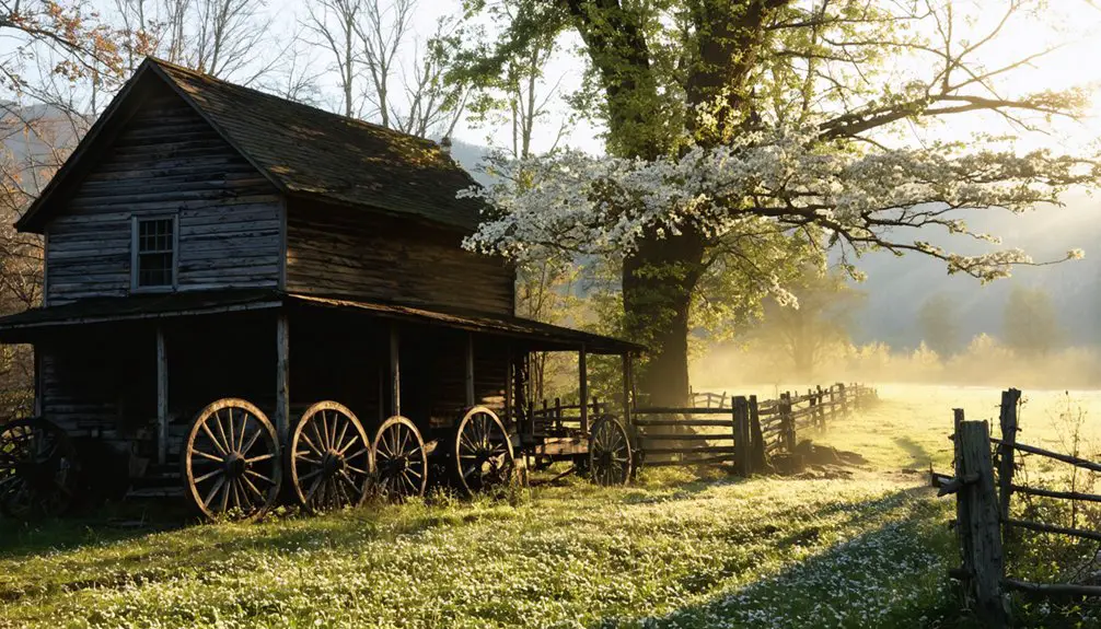
You’ll find Elkmont within Great Smoky Mountains National Park, where 16 preserved vacation cottages from the 1910s logging era remain open for exploration. The site, known as “Daisy Town,” features restored cabins that once served as a summer vacation community where families held lifetime leases.
Port Royal State Historic Park commemorates the Red River settlement that sent four delegates to Tennessee’s 1796 Constitutional Convention before railroad bypasses sealed its decline.
In Giles County, Prospect‘s historical landmarks mark one of the county’s first settlements circa 1806-1808, while nearby Campbellsville preserves Civil War-era structures dating to 1808. The area historically served as a crossing point for Andrew Jackson and was once known as “Hell’s Half Acre.”
These sites document economic obsolescence rather than urban legends, revealing how transportation networks determined community survival across Tennessee’s developmental trajectory.
Communities Lost Beneath Tennessee’s Reservoirs
Tennessee’s reservoir system conceals entire communities beneath its waters, primarily resulting from the Tennessee Valley Authority‘s aggressive dam construction program between 1933 and 1944.
You’ll find that towns like Loyston (Norris Reservoir), Willow Grove (Dale Hollow Lake), and portions of settlements near Hales Bar Dam were systematically evacuated, demolished, and flooded to create hydroelectric power and flood control infrastructure.
These submerged ghost towns represent a distinct category of lost communities, where residents attended farewell gatherings—such as Loyston’s 1942 community picnic—before watching their ancestral homes disappear under rising reservoir waters. The displacement affected 70 residents in Loyston alone, who were forced to relocate as structures including churches, schools, and businesses were permanently submerged beneath the reservoir. Jefferson vanished when Stones River was dammed to create Percy Priest Lake in the 1940s, leaving only a cellar with caved-in stairs and scattered foundations.
TVA Dam Construction Impact
- Kentucky reservoir counties lost up to 32% of their population between 1940 and 1950.
- High unemployment persisted in reservoir areas long after construction ended.
- Farmer numbers declined drastically despite TVA’s stated revitalization goals.
- The agency displaced approximately 16,500 families while acquiring over 1.3 million acres through eminent domain procedures that often bypassed jury trials.
- You’ll find this federal project prioritized high-cost hydroelectricity over individual property rights, leaving communities permanently submerged and destroying the region’s most technologically advanced agricultural operations.
- Dam construction flooded towns across seven states, including parts of Tennessee, Alabama, Mississippi, Kentucky, Georgia, North Carolina, and Virginia.
Notable Submerged Town Examples
Where once thriving communities conducted daily commerce along Tennessee’s waterways, only murky reservoir depths remain.
You’ll find Butler’s relocated graves and Big Barren’s drowned memories beneath Watauga and Norris reservoirs respectively.
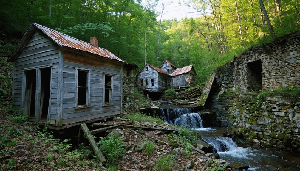
Loyston’s post office, general stores, and café disappeared underwater in the 1930s, along with ancient artifacts that documented generations of settlement.
Willow Grove, established by New York families in 1785, vanished beneath Dale Hollow Reservoir despite its century-old churches and gristmill.
The Army Corps of Engineers and TVA submerged Noeton under Cherokee Lake, first exhuming its cemetery and dismantling underground tunnels.
Butler endured major floods in 1867, 1868, 1901, 1902, 1924, and 1940 before its final inundation by Watauga Lake in 1948.
May Spring disappeared beneath Cherokee Lake in 1942, its historic farm and mill known for producing high-quality flour now lost to the reservoir’s depths.
These forced relocations destroyed self-sufficient economies—Butler moved 50 businesses and 1,300 graves while Loyston’s replacement community failed entirely, demonstrating government power’s permanent consequences.
Reservoir Creation Timeline Effects
Between 1933 and 1979, the Tennessee Valley Authority’s dam construction program systematically erased dozens of communities from Tennessee’s landscape, transforming populated valleys into engineered waterscapes that prioritized electricity generation and flood control over centuries of settlement patterns.
Timeline of Community Displacement:
- Early Phase (1933-1945): Initial dam engineering projects displaced agricultural communities along the Tennessee River’s main channel, with Wilson Dam and Kentucky Dam fundamentally altering reservoir ecology across thousands of acres.
- Mid-Century Expansion (1946-1965): Accelerated construction inundated established settlements, forcing residents to relocate as federal authority superseded local sovereignty.
- Final Projects (1966-1979): Tellico Dam’s completion submerged 330 farms despite sustained resistance. This exemplifies how centralized planning overrode community autonomy through eminent domain powers.
Former County Seats That Became Ghost Towns

Throughout Tennessee’s political evolution, several communities that once wielded significant administrative power as county seats now stand as silent remnants of governmental decisions and economic shifts. Vernon lost its Hickman County seat status in 1823 when border changes favored Centerville.
Montgomery’s decline on the flood-prone Emory River led to Wartburg’s selection as Morgan County’s seat. Overton County citizens voted in 1833 to relocate their courthouse from Monroe to Livingston.
McNairy County abandoned Purdy for Selmer in 1891, following the Mobile and Ohio Railroad‘s route. Lewis County experienced three seat changes, ultimately abandoning Gordon in favor of Hohenwald by 1897.
These sites now offer tourism opportunities through remaining historical markers, while historical preservation efforts document Tennessee’s administrative transformation. You’ll find these abandoned seats scattered across middle Tennessee’s rural landscape.
What Caused These Tennessee Towns to Disappear
Tennessee’s ghost towns emerged from two primary forces: catastrophic displacement through federal reservoir projects and gradual economic collapse.
When the Tennessee Valley Authority constructed dams in the 1930s-1950s, entire communities like Loyston and Old Jefferson vanished beneath reservoir waters, forcibly relocating populations.
Simultaneously, the decline of coal mining, agricultural economies, and mineral spring tourism left dozens of rural settlements without viable economic foundations, triggering systematic abandonment across multiple counties.
Reservoir Flooding Submerged Communities
During the Great Depression, President Franklin D. Roosevelt’s Tennessee Valley Authority permanently altered Tennessee’s landscape through strategic reservoir creation. You’ll find entire communities now rest beneath massive lakes, their stories preserved only through historical preservation efforts and occasional archaeological discoveries when water levels drop.
Three Major TVA Submersions:
- Loyston (1936) – Norris Dam flooded this 100-year-old Clinch River settlement beneath what locals call “Loyston Sea,” the widest section of Norris Lake.
- Butler (1948) – Tennessee’s only incorporated town completely submerged by TVA’s Watauga Dam. Residents relocated 12 homes, 50 businesses, and 1,300 graves before inundation.
- May Spring (1942) – Cherokee Dam’s impoundment consumed this Grainger County community, including its renowned mill and historic farmsteads.
These reservoirs sacrificed established settlements for flood control and power generation, erasing communities from Tennessee’s physical landscape.
Economic and Infrastructure Decline
While TVA’s deliberate flooding erased communities through government intervention, market forces proved equally destructive to Tennessee settlements dependent on extractive industries. Claiborne County’s coal collapse eliminated 267 jobs and $71.2 million in annual output by 2013, devastating towns like Wilder that lacked economic resilience beyond mining.
When resources depleted, support businesses—general stores, taverns, blacksmiths—abandoned operations as consumers fled. Ghost towns proliferated across eastern Tennessee as ore and timber dwindled, leaving deteriorating infrastructure.
You’ll find roads still missing from former mining areas, while $24 million in cleanup work remains projected. Without infrastructure revitalization, these communities couldn’t adapt. Coal companies abandoned cleanup obligations, compounding losses through WWII-era outmigration.
Resource exhaustion compelled residents toward productive areas, transforming once-thriving settlements into abandoned remnants.
Ghost Towns in the Great Smoky Mountains National Park
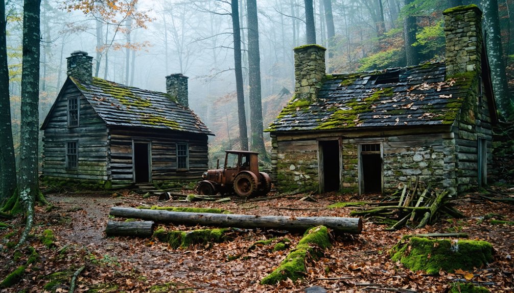
The Great Smoky Mountains National Park harbors five significant ghost towns within its 522,427 acres, each representing distinct chapters in Southern Appalachian settlement history. You’ll find these abandoned settlements preserved as both historical preservation sites and tourist attractions, offering unfiltered glimpses into pre-park communities.
Notable Ghost Towns:
- Elkmont – Originally a logging community (1900s), now featuring 18 preserved cabins with 4 accessible for public viewing along Jakes Creek Trail.
- Cades Cove – The largest ghost town containing multiple historical structures, accessible via scenic Loop Road, with documented cemetery phenomena.
- Cataloochee Valley – Railroad-era settlement forcibly evacuated by 1940 during park establishment.
You’ll also discover Proctor, Judson, and the Noland Creek Trail Area, which winds through homestead remains and approximately 200 cemeteries—testament to Appalachia’s complex displacement narrative.
The True Scope: Estimates Range From Dozens to Hundreds
Cataloging Tennessee’s ghost towns reveals striking discrepancies between official records and historical reality. You’ll find Wikipedia lists only 17 sites, while researchers document anywhere from a dozen to over 100 abandoned communities statewide. The mid-range counts hover around 18-19 documented locations, excluding underwater towns submerged by TVA projects.
Yet national patterns suggest Tennessee harbors far more undocumented settlements—failed mining camps, defunct railroad stops, and forgotten agricultural hamlets. These archaeological sites represent various phases of urban decay: former county seats like Port Royal and Vernon, mountain communities erased by park creation, and industrial towns abandoned when resources depleted.
The incomplete catalogs you’ll encounter underscore how many settlements vanished without formal recognition, their stories preserved only through local memory and fragmentary archival records rather than official documentation.
Gold Rush Camps and Military Outposts Now Abandoned
Tennessee’s extractive industries and labor conflicts left behind a distinct category of abandonment sites where economic ambition collided with geological reality and social upheaval.
Three distinct mining ghost stories emerged from Tennessee’s frontier capitalism:
- Coal Creek War battlefields – Militia Hill preserves cannon emplacements and trenches from 1891 battles where miners fought convict lease labor. Mining relics include bullet casings scattered along railroad grades where government troops clashed with free laborers.
- Coker Creek gold rush camps – The 1827 discovery sparked Tennessee’s gold fever, though lean ore yielded only $250,000 total. Massive tailing piles from bucket dredges mark abandoned commercial operations.
- Great Smokies copper complexes – One site’s 2,400-foot shaft ranks as the second deepest abandoned mine in the National Park System, featuring collapsed administrative buildings and rusted hoisting equipment.
You’ll find these sites eligible for historic preservation yet largely unexplored.
Preserved vs. Submerged: Different Fates of Tennessee’s Lost Towns
While extractive industries scattered rubble across Tennessee’s mountainsides, hydroelectric ambitions erased entire communities beneath reservoir waters—creating a sharp divide between ghost towns you’ll explore on foot versus those requiring scuba gear.
Preserved sites like Cades Cove and Elkmont’s sixteen restored cabins remain accessible, showcasing farming decline and railroad abandonment through intact structures. You’ll find historical markers at Vernon, Montgomery, and Randolph commemorating vanished prosperity.
Conversely, TVA projects submerged at least eight communities entirely: Loyston beneath Norris Lake, Willow Grove under Dale Hollow Reservoir, and Old Butler drowned alongside Morganton.
Of Tennessee’s estimated 100+ ghost towns, roughly twelve to seventeen receive official recognition, split between land-preserved remnants you can photograph and lake-buried settlements accessible only through archival records and bathymetric surveys.
Frequently Asked Questions
Can You Legally Explore and Photograph Tennessee’s Ghost Towns?
You can legally explore and photograph Tennessee’s ghost towns on public lands like Elkmont and Cades Cove, where historical preservation permits urban exploration. However, you’ll need landowner permission for private sites to avoid trespassing violations and respect preservation efforts.
Are There Any Haunted Ghost Towns in Tennessee With Paranormal Activity?
You’ll find Tennessee’s ghost towns rich with haunted legends and local folklore, though paranormal sightings lack archival verification. While communities like Elkmont spark imagination, documented supernatural activity remains elusive. You’re free to explore these atmospheric sites and draw your own conclusions.
Which Tennessee Ghost Town Is Easiest to Access for Families?
Cades Cove offers you Tennessee’s most family-accessible ghost town experience. Its historical preservation efforts and tourism development provide paved loop roads, letting you explore authentic 19th-century structures without strenuous hiking through Great Smoky Mountains National Park.
Do Any Ghost Towns in Tennessee Have Remaining Residents?
Unlike Pompeii’s frozen moment, Tennessee’s ghost towns remain truly abandoned. You’ll find no residents in documented sites like Elkmont or Wheat—only historic preservation efforts and tourist attractions maintain their physical presence, offering unrestricted exploration of these forsaken communities.
What Should I Bring When Visiting a Tennessee Ghost Town?
You’ll need sturdy boots, water, maps, and safety gear when exploring abandoned structures. Bring cameras for documentation, respecting historical preservation guidelines. Pack out all trash, avoid disturbing artifacts, and stay alert on unstable terrain throughout Tennessee’s backcountry ghost town sites.
References
- https://en.wikipedia.org/wiki/List_of_ghost_towns_in_Tennessee
- https://www.loveexploring.com/gallerylist/188219/the-us-state-with-the-most-ghost-towns-revealed
- https://www.tnmagazine.org/19-ghost-towns-in-tennessee-that-are-not-underwater/
- https://www.ezhomesearch.com/blog/the-past-and-future-of-ghost-towns-in-tennessee/
- https://www.tnvacation.com/trip-inspiration/articles/ghost-towns-tennessee
- https://freepages.rootsweb.com/~gtusa/history/usa/tn.htm
- https://www.youtube.com/watch?v=7mYZYhQaj4U
- https://www.geotab.com/ghost-towns/
- https://www.tripadvisor.com/Attraction_Review-g143031-d8426768-Reviews-Elkmont_Ghost_Town-Great_Smoky_Mountains_National_Park_Tennessee.html
- https://www.pigeonforge.com/elkmont-ghost-town/