To locate remote coastal fishing remnants, look for distinct geographic features like rocky coastlines, lagoons, and natural harbors. Deploy aerial imaging through drones with 4K or multispectral capabilities to detect subtle topographical changes. Use magnetometers and ground-penetrating radar for subsurface anomalies. Search for semi-circular stone alignments perpendicular to shorelines in tidal zones. Shell middens often indicate ancient fishing sites. Collaborating with Indigenous knowledge holders dramatically increases your chances of successful identification.
Key Takeaways
- Look for distinctive V-shaped or semi-circular stone alignments perpendicular to shorelines that maximize fish capture during tidal movements.
- Deploy aerial imaging systems and drones with 4K capabilities to detect subtle topographical changes invisible at ground level.
- Search near nutrient-rich upwelling zones, rocky coastlines, and natural harbors where productive fishing grounds historically existed.
- Utilize side-scan sonar, magnetometers, and underwater camera systems to identify submerged structures and artifacts.
- Partner with Indigenous knowledge holders who can provide traditional ecological information for identifying promising site locations.
Understanding Coastal Archaeological Signatures

The complexity of coastal archaeological sites demands specialized knowledge of formation processes and identification methods. When searching for fishing remnants, you’ll need to distinguish between natural and human-driven changes in the landscape.
Coastal dynamics—including sea-level shifts, wind erosion, and sediment deposition—directly influence where ancient populations established settlements and how these sites appear today. Researchers like Inda have demonstrated that key archaeological locations such as Cape Polonio serve as model sites for understanding coastal occupation patterns. Remote sensing techniques provide crucial data for identifying these coastal archaeological features from aerial and space-based platforms.
Archaeological signatures of fishing activities often include fire-cracked-rock piles, lithic scatters, and structural remains that yield distinctive spectral patterns when viewed through satellite imagery.
Look for clusters in stable eolian features or exploitation zones created by historical sea-level changes. The association between artifacts, ecofacts, and features provides vital information about specific fishing activities.
Key Geographic Features That Signal Ancient Fishing Sites
When searching for ancient fishing sites along coastal regions, you’ll need to identify specific geographic features that consistently signal human exploitation of marine resources.
Ancient fisheries developed where coastal geomorphology created ideal conditions for abundant catches.
Look for these telltale indicators:
- Nutrient-rich upwelling zones – Areas where deep waters rise, creating productive fishing grounds often marked by shellmounds or sambaquis.
- Rocky coastlines and islets – Natural fish habitats and strategic fishing positions with evidence of settlement clusters.
- Lagoon-adjacent landscapes – Brackish environments that attracted diverse species, particularly mullets.
- Intertidal zones with stake patterns – Remnants of fish traps in heart or chevron shapes positioned to capitalize on tidal movements.
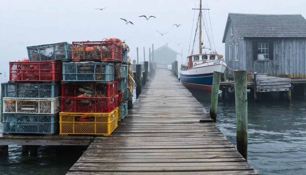
You’ll find most significant sites near natural harbors that offered both protection and direct access to marine resources. The Brazilian coastline contains over 2,000 sambaquis serving as burial grounds and evidence of prehistoric fishing communities. Estuaries often reveal sophisticated systems that demonstrate ecological wisdom passed down through generations of Indigenous populations.
Essential Tools and Technologies for Remote Site Detection
Your search for remote coastal fishing remnants requires three primary technology categories to maximize detection efficiency.
Aerial imaging systems provide high-resolution topographical data that reveals subtle shoreline alterations invisible at ground level.
Geophysical survey equipment, including magnetometers and ground-penetrating radar, detects subsurface anomalies, while underwater detection tools such as side-scan sonar identify submerged structures obscured by sediment or marine growth. Advanced hydrophone systems can detect unauthorized vessel movement through specific acoustic signatures of boat engines, helping identify areas of recent fishing activity. Satellite imagery utilizing VIIRS technology can identify vessels using light to attract catch in remote coastal waters, providing crucial data about fishing patterns in hard-to-access areas.
Aerial Imaging Systems
Advanced aerial imaging systems serve as foundational tools for detecting remote coastal fishing remnants across difficult-to-access terrains. These remote sensing platforms revolutionize your ability to discover historical sites without physical constraints.
Drone-based 4K imaging and multispectral technologies detect subtle topographical changes that signal human modification, while aerial mapping techniques identify patterns invisible at ground level. The approach is highly cost-effective for surveying extensive coastal regions with archaeological significance. Autonomous flight mode enables researchers to capture consistent data in hazardous coastal environments without risk to personnel.
When implementing aerial imaging systems, you’ll benefit from:
- Autonomous drone flights capturing geotagged imagery for precise spatial mapping
- Integration of LiDAR data revealing microtopographical features under vegetation
- Hyperspectral sensors detecting material composition differences in eroded structures
- Historical aerial photograph comparison tracking site changes over decades
These technologies transform archaeological reconnaissance by providing GIS-ready data for thorough analysis, empowering you to explore remote coastal areas efficiently while preserving their integrity.
Geophysical Survey Equipment
Geophysical survey equipment forms the backbone of any systematic coastal archaeology project seeking to identify submerged or buried fishing remnants.
You’ll find magnetometer applications particularly valuable for detecting ferrous components of ancient fishing operations, offering rapid ground coverage with relatively affordable, portable technology.
For stratified sites, consider GPR advantages that provide precise depth information about subsurface features through electromagnetic pulse reflection. GNSS systems integration enables precise spatial control without establishing local grid systems, significantly streamlining fieldwork in remote coastal locations.
You’ll distinguish between different occupation phases at fishing stations with accuracy unmatched by other methods.
Supplement these primary tools with resistance surveys when investigating suspected masonry structures, and electromagnetic conductivity measurements for thorough site assessment across varying coastal environments.
Integration of multiple geophysical methods, combined with precise positioning systems, delivers the most complete understanding of remote coastal fishing remnants beneath the surface. Early involvement of geophysicists in project design can significantly enhance survey results and interpretation of coastal fishing sites.
Underwater Detection Tools
Five essential underwater detection tools provide the foundation for identifying remote coastal fishing remnants beneath the surface.
When exploring submerged sites, you’ll need specialized equipment to overcome saltwater mineralization and challenging underwater conditions.
Metal detection techniques have evolved to include:
- Handheld detectors with Pulse and Broad Band Spectrum circuits that neutralize saltwater interference
- Boat-towed systems for covering extensive ocean areas when searching for larger targets
- Cable tracking devices that locate both infrastructure and ferrous objects like anchors
- Side scan sonar imaging advancements that produce visual representations of the seabed
For confirming targets, underwater camera systems with AI-powered trace detection provide visual verification.
You’ll find the combination of magnetometers for ferrous materials and broadband detectors for non-ferrous remnants creates the most thorough detection strategy.
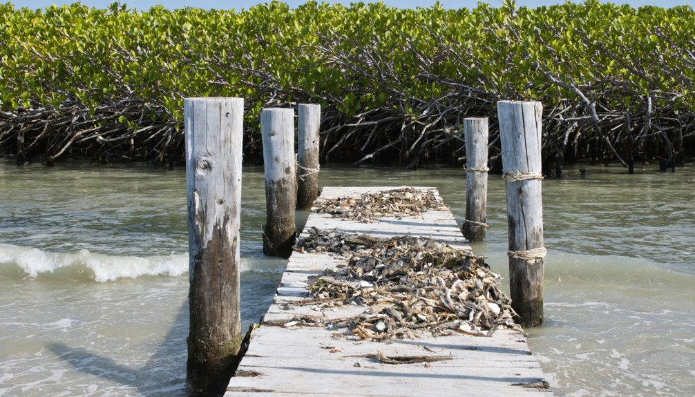
Identifying Fish Trap Structures in Tidal Zones
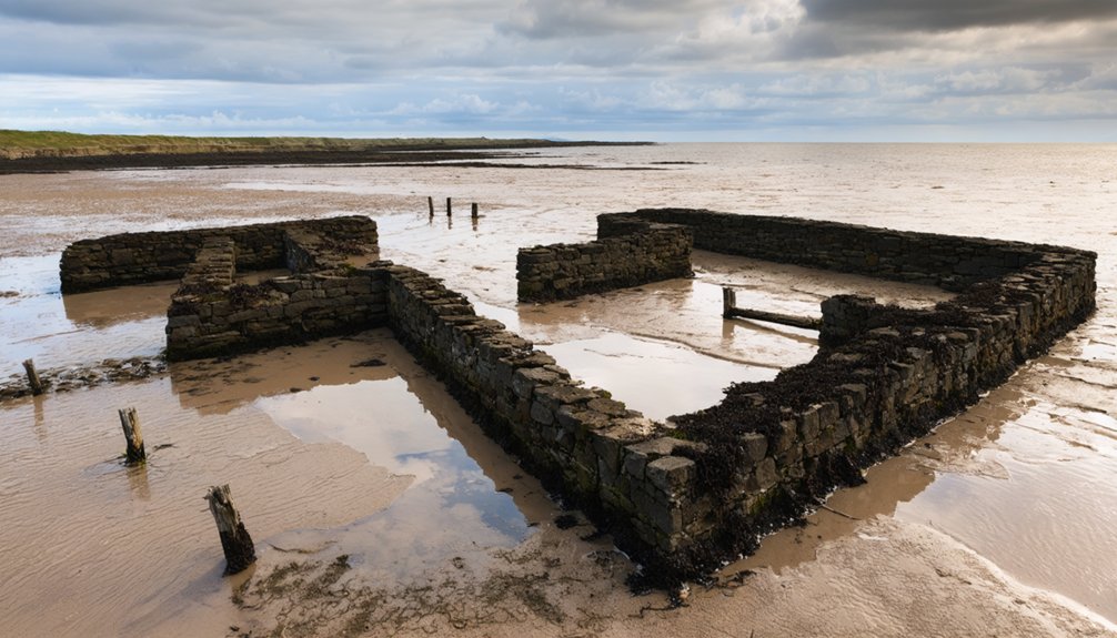
You’ll need to look for distinctive semi-circular or V-shaped stone alignments positioned perpendicular to shorelines in the intertidal zone, as these formations maximize fish capture during tidal movements.
These rock walls typically measure 2-4 meters in width and can extend hundreds of meters in length, with larger stones forming the foundation and smaller cobbles used as stabilizing infill.
When surveying potential trap sites, focus on areas where curved wall sections exploit fish behavior by creating natural turning points that guide fish into enclosed chambers as the tide recedes.
Rock Wall Patterns
Rock wall patterns found in intertidal zones represent sophisticated fishing technologies developed by coastal communities over centuries.
These ingenious rock wall designs exploit natural fish behavior and tidal movements to create effective fish capture mechanisms. You’ll recognize authentic structures by their distinctive curved or arrow-shaped configurations that manipulate water flow during tidal cycles.
When exploring coastal areas, look for:
- Low walls with vertical landward faces and sloped seaward sides designed to reduce wave turbulence
- Heights calculated to submerge under 0.5-1.0m of spring high tide water
- V-shaped or curved formations that channel fish movement inward
- Multiple chambers connected by narrow gaps that selectively trap different fish sizes
The most productive traps exploit natural gullies and incorporate local knowledge of currents, maximizing capture efficiency while allowing juvenile specimens to escape through strategic gaps.
Tidal Zone Positioning
Identifying intertidal fish trap structures requires understanding their strategic positioning within tidal zones.
Look for remnants located between Mean High Water Mark and Mean Low Water Mark on gently sloping mud or sand flats in estuarine settings. These structures exploit tidal fish behavior, positioned to intercept species moving with ebbing or flooding tides.
Effective trap orientation techniques include placement at right angles or obliquely to tidal channels, maximizing catch efficiency.
You’ll find entrances strategically facing the direction of fish movement during tidal changes. Pay particular attention to areas where local hydrology creates natural fish funnels.
V-shaped structures typically point seaward, channeling fish toward a collection point as waters recede. Curvilinear or zigzag patterns indicate designs meant to capture fish during both incoming and outgoing tides.
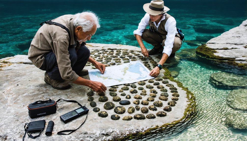
Shell Midden Analysis Techniques for Fishing Evidence
Shell midden analysis serves as a cornerstone methodology for archaeologists seeking evidence of prehistoric fishing activities along coastal regions.
Shell middens reveal ancient coastal fishing practices, offering archaeologists a window into prehistoric maritime subsistence strategies.
When examining these shell deposits, you’ll need multidisciplinary approaches to differentiate cultural middens from natural shell beds. Shell midden preservation varies considerably based on sea-level changes and depositional environments, requiring specialized sampling techniques.
To effectively analyze shell middens for fishing evidence:
- Conduct fragment analysis using standardized collection bags to capture both whole shells and fragments, preventing bias in population reconstructions.
- Apply radiocarbon dating combined with site area measurements to determine usage intensity.
- Examine mortality profiles and size distributions as proxies for fishing pressure.
- Utilize minimally invasive core sampling when dealing with submerged or buried middens.
Maneuvering coastal environments where prehistoric fishing remnants may be located requires systematic assessment of terrain challenges and environmental barriers that can impede access.
Identify natural pathways along beach edges and rocky shores rather than attempting direct climbs or bushwhacking through dense vegetation.
Monitor tidal patterns closely—low tides reveal walkable flats and expose potential artifact locations while high tides can strand you in dangerous positions.
Navigate strategically by using elevation changes to your advantage; walk along cliff bases rather than precarious tops.
Environmental obstacles like sharp rocky outcrops, mangrove thickets, and unstable mud require appropriate equipment—trekking poles, waterproof boots, and GPS devices greatly enhance mobility.
Consider deploying drones to scout difficult terrain before physical approach, reducing unnecessary risk while maintaining your freedom to explore remote coastal fishing sites.
Interpreting Artifact Collections From Marine Contexts
Once artifacts have been located in coastal environments, proper interpretation requires sophisticated analytical approaches tailored to marine contexts. Understanding marine stratigraphy is essential for determining artifact significance within the broader historical narrative of coastal activities.
When analyzing your recovered fishing remnants, follow these steps:
- Evaluate spatial distribution patterns to reconstruct activity areas and behavioral contexts.
- Differentiate between various site types (fishing refuse, settlements, shipwrecks) through assemblage composition.
- Account for post-depositional processes that may have altered the original arrangement.
- Apply GIS mapping to establish chronological sequences and site use patterns.
You’ll need to take into account how biochemical deterioration in marine environments affects different materials, which can skew your interpretation of the assemblage’s original composition and purpose.
Collaborative Approaches With Indigenous Knowledge Holders
Establishing meaningful partnerships with Indigenous knowledge holders represents a fundamental shift in coastal archaeological practices, moving beyond extractive research toward collaborative frameworks that honor multiple ways of knowing.
When seeking coastal fishing remnants, you’ll need to implement co-governance models that integrate Indigenous leadership with scientific inquiry.
Begin by securing free, prior, and informed consent from local communities, developing formal research agreements that outline mutual benefits and responsibilities.
Indigenous collaboration must prioritize reciprocal relationships where traditional ecological knowledge informs site selection and interpretation.
Incorporate community-led documentation processes where knowledge holders participate in fieldwork, offering vital contextual understanding of artifacts and structures.
Knowledge sharing should occur through dedicated capacity-building workshops and intergenerational programs that support cultural continuity while advancing research objectives.
Documentation Methods for Vulnerable Coastal Discoveries
When coastal archaeological discoveries face increasing threats from climate change, industrial development, and natural erosion, extensive documentation becomes critical to preserving cultural heritage data before it’s lost forever.
California has a rich history of settlement and abandonment, with many historic ghost towns in California offering a glimpse into the past. These sites not only attract tourists but also serve as essential focal points for researchers studying the impacts of human activity on the landscape. Efforts to preserve these towns are vital in maintaining the stories and artifacts that reflect the cultural diversity of the region.
Your preservation strategies must combine traditional recording with advanced digital documentation techniques.
- Create extensive field journals with detailed sketches, environmental context notes, and stratigraphic observations.
- Deploy digital photogrammetry for rapid 3D capture, especially in difficult terrain where conventional methods prove challenging.
- Incorporate satellite imagery and aerial photographs to identify threats and contextualize your findings.
- Establish systematic digital databases that record location, function, condition, and threat assessments.
Before disturbing any site, guarantee complete documentation using both traditional survey techniques and modern positioning systems to maintain contextual integrity of coastal fishing remnants.
Frequently Asked Questions
How Do Prehistoric Fishing Remains Differ From Natural Accumulations?
At La Playa archaeological site, you’ll notice prehistoric artifacts like hooks and burnt bones show intentional human processing, while natural formations lack these markers and exhibit random species distribution with weathering patterns.
What Legal Permits Are Required Before Investigating Potential Coastal Sites?
You’ll need ARPA/PRPA federal permits, state coastal regulations compliance, local county permissions, landowner consent for private property, and specialized marine archaeology permits when investigating submerged fishing remnants.
How Can Amateur Archaeologists Contribute Without Disturbing Significant Sites?
80% of amateur contributions come from non-invasive documentation. You’ll advance archaeology through ethical practices like surface observation, GPS mapping, photography, and community engagement while maintaining site integrity for professional examination.
Can Climate Change Impacts Reveal Previously Undiscovered Fishing Remnants?
Yes, you’ll find accelerated erosion from climate change exposes fishing remnants in coastal deposits. Monitor eroding cliff faces and middens where wave action reveals previously inaccessible archaeological discovery sites during your climate adaptation fieldwork.
How Do You Distinguish Between Ceremonial and Utilitarian Fishing Structures?
You’ll identify ceremonial structures through decorative elements, ritual alignments, and sacred locations, while utilitarian tools appear near productive fishing grounds with evidence of repairs, net weights, and functional spatial organization.
References
- https://digitalcommons.calpoly.edu/cgi/viewcontent.cgi?article=1097&context=ssci_fac
- https://www.nature.com/articles/s41598-024-55047-z
- https://www.theartnewspaper.com/2023/08/07/first-nation-village-archaeological-dig-british-columbia
- https://academic.oup.com/tafs/article/133/4/801/7888182
- https://worldarchaeologicalcongress.com/wac10/t16-s01-papers/
- https://www.napali.com/coast/nualolo-kai/
- https://oceanexplorer.noaa.gov/explainers/archaeology/
- https://onlinelibrary.wiley.com/doi/abs/10.1002/gea.21644
- https://www.nps.gov/subjects/ncptt/upload/2006-01.pdf
- https://www.jstor.org/stable/26494837