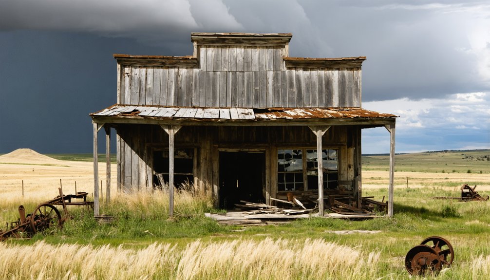
You’ll find Imlay’s ghostly remains in Jackson County, South Dakota, where it emerged as a Milwaukee Road railroad town in 1907. The town flourished briefly as an essential transport hub for local ranchers and farmers until the devastating Dust Bowl years of the 1930s triggered its decline. Today, you’ll need a 4WD vehicle to explore its weathered structures and peaceful grove of trees, though watch for rattlesnakes in abandoned buildings. The site’s rich history holds many more untold stories.
Key Takeaways
- Imlay was established in 1907 as a railroad town along the Milwaukee Road’s line from Murdo to Rapid City.
- The town declined significantly during the Dust Bowl years (1933-1939), losing nearly half its farming population.
- Today, Imlay exists as a ghost town with abandoned structures, including a preserved depot surrounded by a grove of trees.
- Visitors need 4WD vehicles to access the site and should prepare for hazards like rattlesnakes and extreme weather.
- No services are available at the site, requiring visitors to bring water, supplies, and emergency equipment.
The Railroad Town’s Birth and Early Days
When the Milwaukee Road extended its rail line westward from Murdo to Rapid City in 1907, the small town of Imlay sprang to life along South Dakota’s rolling plains.
This railroad expansion brought more than just steel tracks – it delivered the promise of opportunity and connectivity to the region’s ambitious settlers.
You would’ve witnessed the town’s initial layout taking shape around the bustling railroad depot, which quickly became Imlay’s beating heart.
As trains rolled through, bringing supplies and taking local goods to market, the settlement flourished.
Similar to the Grand Trunk Western Railroad’s approach to development, the town featured decorative rail bridges that added character to the landscape.
New residents and merchants, drawn by the railway’s economic potential, established homes and businesses near the tracks.
The town’s strategic position along the Milwaukee Road transformed it into a crucial transportation hub, connecting local farmers and ranchers to distant markets they couldn’t otherwise reach.
Like many other railroad towns of the era, local speculators invested heavily in the surrounding land, anticipating significant returns from the railway’s presence.
Life on the High Prairie
Beyond the railroad’s influence, daily life on Imlay’s high prairie demanded grit and adaptability from its settlers. You’d find yourself hauling water at night from distant WPA springs, while staying alert for rattlesnakes that prowled the grasslands.
During hot, dry summers, the unforgiving climate tested even the hardiest residents’ resolve.
Your children might walk miles to the local schoolhouse, where community traditions brought families together despite their isolation.
Each morning’s long trek to school became a cherished ritual, weaving scattered homesteads into one close-knit prairie family.
Prairie resilience showed in how you’d adapt to the brutal climate – scorching summers and freezing winters. You’d gather in dance halls and churches, sharing stories and resources with neighbors.
Your survival depended on mastering both cattle ranching and basic farming, though the soil rarely yielded abundant crops. Through it all, you’d forge bonds with fellow settlers and nearby Native American communities, creating a unique cultural tapestry on the windswept plains. Like the early settlers who gathered at the first threshing bee, these community events became crucial touchstones of rural life.
Surviving the Dust Bowl Era
If you’d visited Imlay during the devastating Dust Bowl years of 1933-1939, you’d have witnessed the exodus of nearly half its farming families as relentless dust storms stripped away both topsoil and livelihoods.
Those who remained banded together through government relief programs, with many participating in New Deal initiatives while implementing soil conservation techniques like shelter belts and crop rotation. The community’s hardships paralleled those across America when 850 million tons of precious topsoil were lost to erosion in 1935 alone. The Soil Conservation Service stepped in to help farmers adopt better land management practices.
The town’s agricultural lands gradually fell silent as failing farms were abandoned, marking the beginning of Imlay’s shift toward ghost town status.
Economic Impact and Exodus
During the devastating Dust Bowl of the 1930s, Imlay’s once-thriving agricultural economy crumbled under the weight of severe drought and relentless dust storms.
You’d have witnessed widespread economic decline as crop failures and soil erosion decimated local farms, causing a ripple effect that crippled commerce throughout the region. Native grasses had been removed by intensive plowing, leaving the soil vulnerable to erosion. Railroad activity slowed to a trickle, and property values plummeted alongside dwindling tax revenues.
The harsh conditions triggered a massive population migration as farming families abandoned their homesteads in search of better opportunities. Young residents led the exodus, leaving behind an aging population with fewer resources. Local residents’ experiences were captured through Joseph Hutton’s photography, documenting their daily struggles against the relentless dust storms.
While federal programs like the Civilian Conservation Corps offered temporary relief through soil conservation efforts, Imlay never recovered its former liveliness, ultimately accelerating its transformation into a ghost town.
Community Response to Hardship
When faced with the brutal realities of the Dust Bowl, Imlay’s residents forged remarkable networks of mutual support that would prove essential to their survival. You’d find neighbors sharing their meager resources and labor, while local churches stepped up to provide food and shelter. Residents often needed artificial lighting at midday as thick dust clouds turned daylight into darkness.
The community’s resilience shone through their innovative barter systems, trading goods and services when money grew scarce. During gatherings and informal meetings, farmers exchanged critical agricultural advice and emotional support. They’d implement new farming techniques together, like contour plowing and shelter belts, while participating in government soil conservation programs. With nearly half of all farmers requiring government assistance to survive, these support networks became crucial lifelines.
Through poetry, photography, and storytelling, they documented their struggles and strengthened their bonds. These mutual aid networks, combined with federal relief programs and water management initiatives, helped many residents endure the harsh realities of those dust-darkened years.
Agricultural Land Abandonment
As the relentless drought of 1933 tightened its grip on Imlay, you’d witness the heart-wrenching sight of farmers abandoning their once-fertile fields. Without rain or snow, the parched earth offered no refuge for crops or livestock.
You’d watch helplessly as fierce winds stripped away precious topsoil, leaving behind barren landscapes where wheat and hay once flourished. The lack of proper land management and soil conservation practices left the ground defenseless against nature’s fury.
You’d see your neighbors departing one by one, their dreams buried beneath swirling dust storms. Those who stayed relied heavily on government relief programs, but even these couldn’t prevent the exodus.
What Remains Today
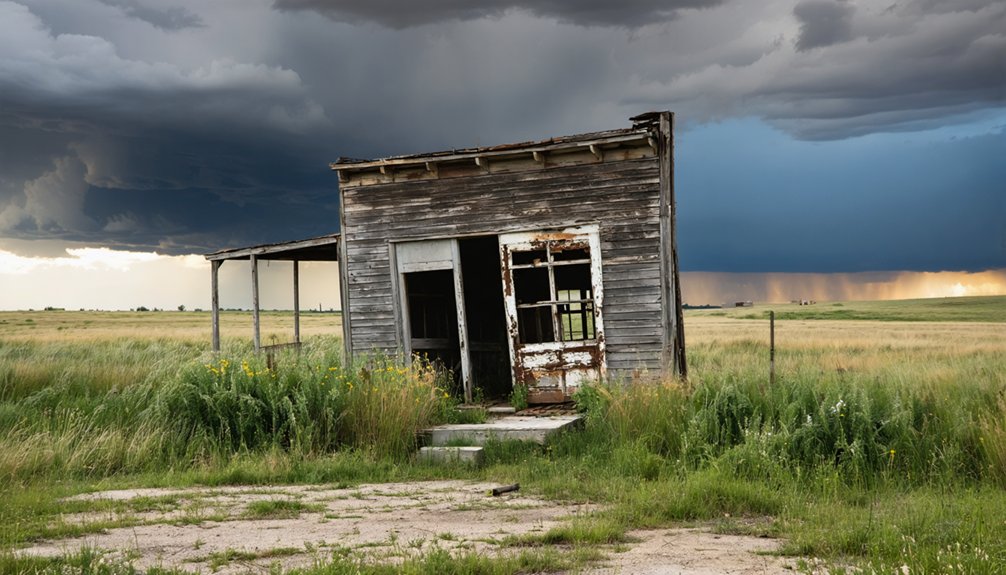
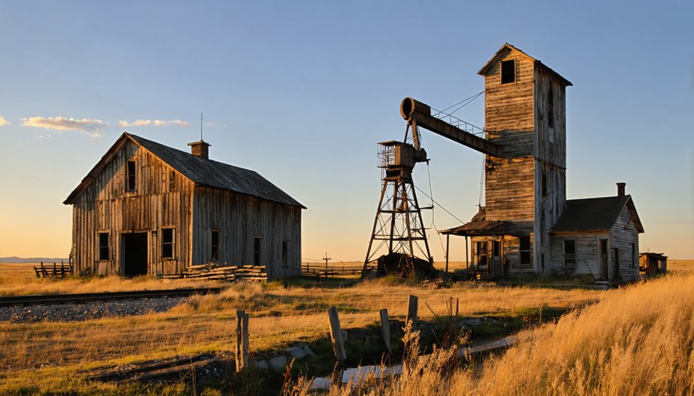
The skeletal remains of Imlay tell a haunting story of South Dakota’s bygone railroad era.
You’ll find the relocated Milwaukee Road depot from Interior, SD, standing as the most prominent ghost town remnant, now serving as a historical landmark. A peaceful grove of trees dots the landscape, offering a stark contrast to the abandoned railroad grade that once brought life to this remote settlement.
As you wander through this historic site, you might find yourself exploring the history of ivanhoe, uncovering stories of the people who once inhabited this area. Each artifact tells a tale, connecting the past to the present and enriching the experience of those who visit. The remnants of structures and personal belongings evoke a sense of nostalgia and curiosity about the lives that once thrived here.
Today, you can explore just a handful of weathered structures that have withstood time’s passage.
While Imlay preservation efforts have saved the depot, the site remains largely neglected, with minimal infrastructure in place. If you’re planning to visit these haunting remnants, you’ll need a 4WD vehicle to navigate the rural terrain, but you’ll be rewarded with unique photography opportunities and a tangible connection to South Dakota’s past.
Natural Hazards and Environmental Challenges
If you’re planning to explore Imlay’s remnants, you’ll need to watch for rattlesnakes that frequently inhabit the abandoned structures and surrounding prairie grasslands.
The region’s extreme weather patterns, from intense summer heat to harsh winter blizzards, can make visiting the ghost town particularly challenging during certain seasons.
You’ll want to time your visit carefully and bring appropriate gear, as these weather conditions have contributed to the deterioration of what little remains of the town’s structures.
Rattlesnake Safety Guidelines
Prairie rattlesnakes, native to South Dakota’s diverse landscapes, present unique challenges for visitors exploring Imlay’s ghost town remnants.
Understanding rattlesnake habitats and rattlesnake behavior is essential for your safety while wandering through the area’s rocky outcrops and abandoned structures.
When exploring Imlay’s historic sites, follow these important safety guidelines:
- Wear sturdy boots and long pants, as snakes often hide in brush and crevices
- Stay alert during dawn and dusk, when rattlesnakes are most active in summer months
- Keep your distance from rocky areas and old foundations where snakes den
- Carry a first aid kit and know the quickest route to medical care
Weather Impact Assessment
Beyond rattlesnake concerns, Imlay’s weather patterns shape every aspect of visiting this historic ghost town.
You’ll encounter dramatic seasonal shifts, from scorching 89.8°F July days to snow-packed winters that blanket the abandoned railroad grade. The high prairie landscape demands climate resilience from both visitors and wildlife, with scattered thunderstorms and powerful winds testing your determination.
During summer months, you’ll find the most favorable conditions for exploring the weathered remnants of this once-thriving railroad town.
However, be prepared for evening storms that can sweep across the sparse vegetation. The area’s historical relationship with extreme weather, particularly the devastating 1930s Dust Bowl, tells a compelling story of survival and eventual decline, reflecting the raw, unforgiving nature of South Dakota’s high plains.
Historical Significance in South Dakota
As a proof of South Dakota’s railroad expansion era, Imlay emerged in 1907 when the Milwaukee Road extended its line from Murdo to Rapid City.
This ghost town’s cultural heritage represents a vital chapter in the state’s development, offering valuable insights into historical preservation efforts.
You’ll discover Imlay’s significance through these key aspects:
- Exemplifies the rise and fall of railroad towns that shaped South Dakota’s settlement patterns
- Demonstrates the devastating impact of the 1930s Dust Bowl on prairie communities
- Preserves tangible evidence of early 20th-century homesteading life
- Contains rare surviving structures, including a relocated Milwaukee Road depot
Today, Imlay’s remnants stand as silent witnesses to the transformative power of transportation networks and environmental challenges that reshaped South Dakota’s landscape.
Planning Your Visit to Imlay
When visiting the remote ghost town of Imlay, you’ll need thorough preparation and self-sufficiency for a safe expedition. Pack plenty of water, food, and emergency supplies, as there aren’t any services or amenities in this abandoned settlement.
Your journey through Pennington County’s rugged terrain requires reliable transportation and a full tank of gas.
Make sure your vehicle is road-worthy and fueled up before venturing into Pennington County’s challenging landscape.
Essential travel tips include carrying both GPS devices and physical maps, as cell coverage can be spotty. Let someone know your plans before heading out.
For safety precautions, bring appropriate clothing for the semi-arid climate, which can shift from intense heat to bitter cold. Since there’s no lodging in Imlay, plan to stay in nearby towns and start your exploration early.
Don’t forget your camera – you’ll want to capture the haunting remnants of this once-thriving community.
Frequently Asked Questions
Were There Any Notable Crimes or Law Enforcement Incidents in Imlay’s History?
You won’t find records of significant crime incidents or law enforcement activity in this remote town’s history – the sparse population and limited documentation left no notable stories behind.
What Happened to the Original Residents After They Left Imlay?
You’ll find the relocation patterns led residents to larger cities and farming communities, seeking better opportunities during the Dust Bowl. Their community transformation ended with complete assimilation into new towns.
Did Native American Tribes Have Any Significant Connection to the Imlay Area?
You’ll find rich tribal history in this area, where Lakota Sioux and earlier Paleo-Indians hunted and traveled. The region held cultural significance, especially with nearby Black Hills being sacred ground.
Are There Any Documented Paranormal Activities or Local Legends About Imlay?
You won’t find documented ghost sightings or established local folklore about Imlay. While abandoned buildings and lonely prairies create an eerie atmosphere, no verified paranormal activities have been officially recorded.
What Was the Peak Population of Imlay Before Its Decline?
You’ll find records showing Imlay reached its peak growth with 50 to 75 residents before the harsh Dust Bowl triggered a rapid population decline, leaving behind another proof of prairie freedom.
References
- https://www.youtube.com/watch?v=Glucs_Rq8Xs
- https://www.ghosttowns.com/states/sd/imlay.html
- https://www.youtube.com/watch?v=_0WNYsFLSLA
- https://www.sdpb.org/rural-life-and-history/2023-08-21/some-black-hills-ghost-towns-and-their-origins
- https://www.sdhspress.com/journal/south-dakota-history-2-2/some-black-hills-ghost-towns-and-their-origins/vol-02-no-2-some-black-hills-ghost-towns-and-their-origins.pdf
- https://www.blackhillsbadlands.com/blog/post/old-west-legends-mines-ghost-towns-route-reimagined/
- https://aberdeenmag.com/2019/01/the-ghost-towns-of-brown-county/
- https://icatchshadows.com/okaton-and-cottonwood-a-photographic-visit-to-two-south-dakota-ghost-towns/
- https://en.wikipedia.org/wiki/List_of_ghost_towns_in_South_Dakota
- https://www.ammhistory.com/The-Railroad-Part-1


