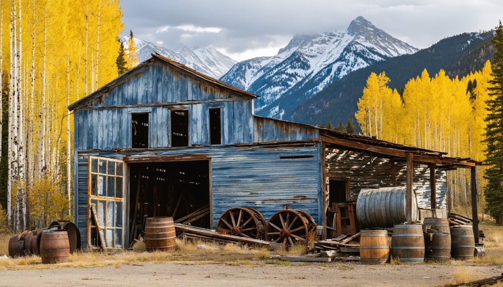
Ironton, Colorado was once a thriving silver mining town established in 1883 that grew to over 1,000 residents. You’ll find it tucked among aspen groves at 9,800 feet in the San Juan Mountains. After the 1893 silver crash, it slowly declined until the last residents left in the 1960s. Today, you can explore about a dozen preserved buildings along a half-mile trail, including the iconic 1891 “White House.” These silent structures tell compelling stories of boom-and-bust resilience.
Key Takeaways
- Ironton was established in 1883 during a silver mining boom and grew to over 1,000 residents within its first year.
- Once a transportation hub with Otto Mears’ Silverton Railroad, the town featured numerous businesses, saloons, and community facilities.
- The 1893 silver crash initiated Ironton’s decline, with its post office closing that September and population dwindling to 48 by 1910.
- Today, visitors can explore about a dozen preserved historic structures among aspen groves, including the notable “White House” from 1891.
- The ghost town is accessible via a half-mile trail at mile marker 85, approximately 8 miles south of Ouray at 9,800 feet elevation.
The Birth of Copper Glen to Ironton (1870s-1880s)
While prospectors had been exploring the San Juan Mountains since the 1870s, the Red Mountain Mining District officially began to take shape in September 1879 when miners ventured north from Silverton along Mineral Creek.
The area’s potential emerged when John Robinson made his momentous Gold Discovery in 1881, unearthing the “fabulously rich” Yankee Girl and Guston mines.
The excitement intensified in August 1882 after Robinson found a massive chunk of silver-lead ore while hunting. His Mining Claims – including the Yankee Girl, Orphan Boy, and Robinson – triggered a rush to the region.
This mining boom led to the rapid development of a settlement called Copper Glen in 1883, which would later become Ironton. The town grew rapidly, and by the end of 1883, it boasted over 1,000 settlers and numerous businesses including saloons and restaurants.
Railway Hub: Connecting the Red Mountain Mining District
The mountain wilderness of Colorado transformed dramatically in 1889 when Otto Mears completed the ambitious Silverton Railroad, establishing Ironton as the pivotal transportation center for the Red Mountain Mining District.
This narrow-gauge line, nicknamed “The Rainbow Route,” conquered the 11,018-foot Red Mountain Pass with remarkable railroad engineering features—including a 200-degree loop, four wyes, and a covered switchback turntable.
You’d have witnessed a transportation revolution as the railroad connected Ironton to surrounding boomtowns like Albany, Guston, and Chattanooga within an eight-square-mile radius.
The economic impact was immediate—mining transportation costs plummeted as high tonnages of ore traveled efficiently to Durango’s smelters.
The Million Dollar Highway also provided crucial access to the mining areas, complementing the railroad’s role in the region’s transportation network.
Despite challenging 5% grades and seasonal winter closures, the railroad dramatically improved mining operations and residents’ quality of life throughout the district, particularly as the region’s population had grown to over 3,000 residents with miners and their families.
Daily Life in a Silver Boom Settlement
Life in Ironton transformed rapidly after January 1883, when prospectors and miners flocked to this high-elevation settlement nestled at 9,800 feet in Colorado’s rugged Red Mountain Mining District.
You’d find a bustling community where over 100 buildings sprang up within just three weeks. Daily routines centered around the mines, where workers endured 10-hour shifts in absolute darkness, with only candle-lit hats illuminating their way.
Mining hazards were constant companions—cave-ins, toxic gas, and flooding threatened lives daily. The eventual formation of sulfuric acid from underground waters significantly damaged mining equipment and increased operational costs.
When not facing these dangers underground, you could visit one of Ironton’s 12 saloons, four restaurants, or the bookstore. Many early residents lived in tents before permanent structures were built. For visitors searching for information about this historical site, consulting disambiguation pages helps distinguish this Ironton from several similarly named locations across the United States.
The Slow Fade: From Bustling Center to Ghost Town
Despite its promising beginnings, Ironton’s decline began abruptly after the silver crash of 1893 when the U.S. government demonetized silver, sending prices plummeting across the market.
The post office closure that September signaled the start of an irreversible economic decline.
When the doors of the local post office closed, the town’s economic fate was sealed forever.
You would’ve witnessed brief revivals—a gold discovery in 1898 sparked temporary renewal, and the Joker Tunnel project (1904-1907) represented a last significant mining effort before ceasing operations in 1914.
By 1910, only 48 residents remained.
The final blow came when railroad operations ended in 1921, cutting vital supply lines.
Two brothers, Harry and Milton Larson, became Ironton’s last inhabitants.
When Milton died in the mid-1960s, Ironton’s mining legacy officially ended, transforming this once-thriving hub into the ghost town you can explore today.
At its peak, Ironton supported a thousand local residents and functioned as an important transportation center for the region.
To protect visitors exploring these historic grounds, the site now employs verification systems that safeguard against unauthorized access while maintaining the authentic experience.
Exploring Ironton Today: What Remains Among the Aspens
Hidden among a grove of aspens just off the Million Dollar Highway, Ironton’s remaining structures beckon modern explorers to step back in time.
You’ll discover about a dozen historic buildings at the southern end of this ghost town, including the impressive “White House” (1891) and an 1889 residence with a covered path to its outhouse.
The easy half-mile trail starts from a small turnout at mile marker 85, approximately 8 miles south of Ouray. The elevation sits at 9806 – 9875 feet, making it a perfect high-altitude exploration opportunity.
When walking these aspen trails, you’ll encounter:
- Preserved structures maintained by the Ouray County Historical Society
- Historical signage revealing Ironton’s hidden history
- Panoramic San Juan Mountain views framing the abandoned townsite
- A glimpse into Colorado’s mining past, freely accessible yet carefully protected
Frequently Asked Questions
What Happened to Milton Larson’s Property After His Death?
Like a torch passing through generations, Milton’s legacy lived on as his property ownership transferred to the Gerard family, who preserved it for 41 years before you could freely explore it.
Are There Any Dangerous Abandoned Mine Shafts Near Ironton?
Yes, you’ll find numerous unmarked and dangerous mine shafts throughout Ironton. They pose serious exploration risks including collapses, toxic gases, contaminated water, and heavy metal exposure. Mine safety is critical.
What Supernatural Legends or Ghost Stories Surround Ironton?
The veil between worlds thins at Ironton. You’ll hear about spectral miners near haunted locations like the turntable, a phantom train’s rumble, and ghostly figures at dusk causing unexplained cold spots.
Exploring the area further leads you to historic landmarks in Bailey, Colorado, where stories of the past echo through the trees. Local lore tells of eerie encounters with lost souls who wander the grounds, urging visitors to pay their respects. As twilight descends, the atmosphere becomes charged with an otherworldly presence, captivating those who seek tales of the unexplained.
Can Visitors Take Artifacts or Souvenirs From Ironton?
No, you shouldn’t take artifacts from the site. Souvenir regulations prohibit removing historical items from public land. Artifact preservation is legally mandated, and you’ll face potential prosecution for disrupting this historical record.
When Is the Best Season to Photograph Ironton’s Ruins?
Time stands still where ghosts of miners roam. You’ll capture Ironton’s essence best in autumn when golden aspens frame weathered structures with dramatic best lighting. Fall’s seasonal colors create perfect contrast against rusty ruins.
References
- https://www.uncovercolorado.com/ghost-towns/ironton/
- https://coloradosghosttowns.com/Ironton COlorado.html
- https://www.gjhikes.com/2017/04/ironton-townsite.html
- https://en.wikipedia.org/wiki/Ironton
- https://myhikes.org/trails/abandoned-ironton-townsite-trail
- https://boxcanyonblog.blogspot.com/2017/12/ironton-ghost-town-remembered-and.html
- https://westernmininghistory.com/towns/colorado/ironton/
- https://www.youtube.com/shorts/ILDJiXtj53E
- https://www.airial.travel/attractions/united-states/ironton-ghost-town-gVrS7Ny5
- https://www.legendsofamerica.com/ironton-colorado/


