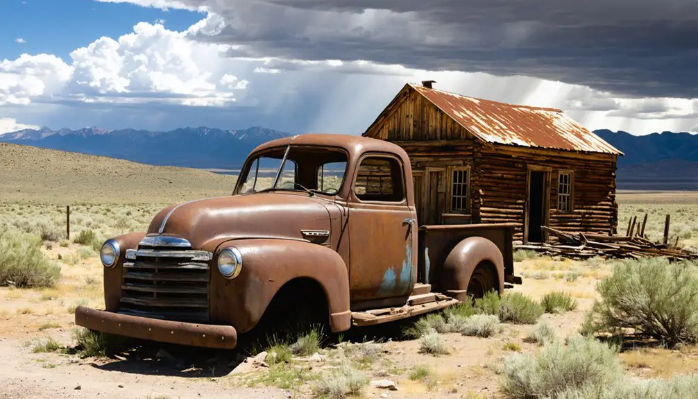
You’ll discover Jungo’s mining heritage in Humboldt County, Nevada, where gold extraction operations began in 1907. The Sawtooth Mill processed rich ore yields of up to $1,495 per ton in gold and 20 oz. of silver, attracting thousands of miners to this desert outpost. Today, you can explore the preserved ruins via Jungo Road, though high-clearance vehicles are recommended. The weathered structures and rusting equipment hold secrets of Nevada’s industrial past waiting to be uncovered.
Key Takeaways
- Jungo was a mining town established in 1907, known for its gold-copper deposits and the significant Sawtooth Mill processing operation.
- Located in Humboldt County, Nevada, Jungo is accessible via Jungo Road, a rough dirt route about 100 miles from Gerlach.
- The town experienced its peak during the mining boom, hosting up to 5,000 miners and featuring basic wooden structures and stone buildings.
- Mining operations included both placer and lode techniques, with some ore yields reaching $1,495 per ton in gold.
- The ghost town’s preserved ruins include weathered structures, mine tunnels, and rusting equipment maintained by Nevada’s arid climate.
Origins and Mining Foundations
While prospectors had explored Nevada’s remote regions for decades, Jungo’s mining story began in earnest around March 1907 when small-scale operations took root along what would become Jungo Road.
You’ll find Jungo history marked by the rapid development of multiple mine tunnels and camps, with the Sawtooth Mill emerging as an essential ore processing site.
Early mining techniques included both surface and underground operations, evidenced by the numerous mining claims that dotted the landscape. Recent explorations revealed two mining claims that still showcase the area’s rich mining heritage.
Though the initial mining boom proved short-lived, it established the foundation for larger ventures.
The area’s mineral wealth, particularly its “Big Copper Deposits,” attracted mining experts who confirmed the region’s viability.
With abundant water sources and adequate grazing for livestock, Jungo’s early infrastructure supported a growing community of determined miners seeking their fortune in Nevada’s rugged terrain. The town followed a familiar pattern seen in Nevada’s 600 ghost towns, eventually succumbing to economic decline.
Getting There: Roads and Routes
You’ll find Jungo primarily accessible via Jungo Road, a rough dirt route stretching about 100 miles east from Gerlach, Nevada, where you should fuel up before departure.
The road conditions vary considerably by season, with washboarding and unimproved sections requiring high-clearance or 4WD vehicles, especially east of Sulphur. According to the Nevada Road Atlas, detailed maps of this remote route are essential for safe navigation. As one of over 800 ghost towns in Nevada and California, proper planning is crucial for a successful visit.
As visitors navigate through this rugged terrain, they will find themselves exploring Lahontan City’s history, which includes remnants of mining operations and a unique glimpse into the past. The stories of those who once inhabited this area unfold as you wander through the ruins and interpretive signs. These historical insights enrich the experience and highlight the importance of understanding the region’s heritage while enjoying its natural beauty.
Following the historic California Trail’s Noble’s Cutoff, you can navigate using the parallel Feather River rail line and nearby Kamma Mountains as key landmarks.
Main Access Via Gerlach
Located at the western gateway to Jungo Road, the small town of Gerlach serves as the primary access point for reaching Jungo Ghost Town.
You’ll find this vital Gerlach gateway at the intersection of County Route 447, where the unpaved Jungo Road begins its eastern stretch through remote Nevada terrain. As your last stop for supplies, Gerlach provides essential services before you venture onto the rugged dirt road.
For ideal Jungo accessibility, you’ll want to reach Gerlach via Nevada State Route 447, whether you’re coming from Fernley to the south or Pyramid Lake communities to the north.
This historic route was once designated as State Route 49 before being decommissioned in 1976.
From here, you’ll head east on Jungo Road, crossing the Kamma Mountains and passing Sulphur ghost town before reaching your destination. The journey covers approximately 40 miles to Sulphur, making it a significant trek through the desert landscape.
Seasonal Road Conditions
Seasonal weather patterns considerably impact road conditions around Jungo Ghost Town, making accessibility highly dependent on the time of year.
You’ll need thorough road preparation to navigate seasonal hazards, especially during spring thaws and winter storms when dirt roads transform into challenging mud bogs.
Recent encounters with BB-sized hail on regional highways demonstrate the unpredictable weather threats drivers may face. Similar to conditions at White Mountain Ranger District, road access can change rapidly with weather patterns.
- Summer offers your best window for access with stable, dry surfaces
- Spring brings muddy conditions that can trap even 4×4 vehicles
- Winter creates treacherous ice patches and potential snow blockages
- Fall shifts demand extra caution as temperatures fluctuate
- Thunderstorms can strike suddenly, turning gravel roads dangerous
Monitor Nevada DOT’s 511 system and weather forecasts before your journey.
The area’s remote nature means you’ll need to stay flexible with travel plans and bring emergency supplies, as maintenance on these rural routes is limited.
While reaching Jungo Ghost Town requires careful navigation through remote terrain, the primary access route follows Jungo Road, an unimproved dirt track that stretches east to west across northern Nevada.
You’ll find this former State Route 49 connects to County Route 447 near Gerlach on the west and extends to Winnemucca on the east, roughly 64 miles away.
Located 35 miles west of Winnemucca, this ghost town site requires careful trip planning.
This historical path follows the Applegate-Lassen Trail that pioneers used to reach northern California settlements in the 1800s.
To overcome navigation challenges, you can use the parallel Feather River Route railroad tracks as a reliable reference point.
Key landmark identification includes the Kamma Mountains northeast of Sulphur and the expansive Black Rock Desert.
You’ll need a high-clearance vehicle, detailed maps, and GPS with updated county data, as road signs are sparse.
Remember to stock up on supplies in Gerlach or Winnemucca, as you won’t find services along this remote stretch.
The Desert Setting and Natural Features
Deep in the heart of Humboldt County, Nevada, Jungo rests within a stark and unforgiving desert landscape that epitomizes the Great Basin’s rugged terrain.
You’ll find a desert ecology shaped by extreme temperatures, minimal rainfall, and persistent winds that sweep across the sagebrush-dotted expanses. The area’s rich mineral resources have left their mark through numerous mining claims and tunnels carved into the surrounding hills.
- Ancient sulfur deposits and precious metal veins lie hidden beneath the rocky surface
- Hardy desert plants cling to life in the sandy, gravelly soil
- Natural springs, like Rabbithole Springs, provide rare oases in the arid landscape
- Mining tunnels and claims stretch across thousands of acres of untamed terrain
- Weathered hillsides bear evidence to millions of years of geological forces
Life During the Mining Era
You’d find miners working long, grueling hours in Jungo’s mines during the early 1900s, extracting ore valued at nearly $30 per pound while operating increasingly mechanized equipment.
Despite harsh desert conditions, you could see a structured community take shape around the mines, with framed houses, stores, and saloons serving as gathering spots for both temporary prospectors and permanent residents.
Your daily life would’ve revolved around the mining operations that dominated the town’s economy, where the promise of striking it rich was tempered by the physical demands and financial uncertainty of frontier mining life.
Daily Mining Operations
Miners flocked to the rich gold veins of Jungo’s Alta Formation during the early 1900s, employing both placer and lode mining techniques to extract precious metals. Your daily routines would’ve started at dawn, battling harsh labor challenges as you worked the mines until twilight.
At the mines, you’d find:
- Hand-hewn tunnels stretching deep into the earth, supported by timber frames
- The rhythmic sounds of picks and shovels breaking through rock
- Mechanical hoists and conveyors moving precious ore to waiting carts
- Workers enduring dangerous conditions from toxic gases to cave-ins
- The bustling Sawtooth Mill crushing ore to release its golden treasure
You’d transport the crushed ore for processing through gravity separation and chemical treatment, while waste rock piled near the mine entrances.
During peak seasons, this cycle repeated daily as miners pursued their dreams of striking it rich.
Community Living Conditions
Life in Jungo revolved around simple wood-framed houses and a handful of stone buildings that dotted the rugged landscape, where several hundred residents endured harsh living conditions during the town’s peak mining era.
You’d find basic amenities scarce, with no running water or electricity, and you’d rely on wood or coal stoves for heating and cooking. Community gatherings at the local saloons, stores, and schoolhouse provided essential social interactions to combat the isolation of frontier life.
Daily threats included rattlesnakes, mine accidents, and the ever-present risk of fire – as evidenced by the devastating blaze of 1900. Medical care wasn’t available, and you’d pay premium prices for limited food and supplies due to the town’s remote location.
Legacy of the Seven Troughs Connection
While Jungo’s primary role was as a railroad hub, its historical significance deeply intertwined with the Seven Troughs mining district‘s rise and fall between 1905 and the 1920s.
You’ll find that Jungo’s Seven Troughs legacy shaped northwestern Nevada’s mining narrative through essential supply connections and transportation networks.
- The district’s boom brought 5,000 miners and entrepreneurs, creating a network of towns dependent on Jungo’s rail access.
- Progressive labor reforms emerged with the 1907 strike securing eight-hour workdays at $5 wages.
- The Coalition Cyanide Plant of 1911 showcased industrial innovation and mining evolution.
- Natural disasters, including the 1912 flood, accelerated the district’s decline.
- Tunnel Camp’s 1927 drainage project represented the final major attempt to revive the area’s mining fortunes.
Mining Operations and Technology
Located within the Jackson Mountains Terrane, Jungo’s mining operations centered on intrusion-related gold-copper deposits that mirrored similar formations found in Alaska, British Columbia, and Yukon.
You’ll find evidence of early mining technologies through the district’s evolution, from basic hand tools and packhorses to more sophisticated ore extraction methods targeting structurally controlled vein systems.
The area’s rich mineralization, yielding up to $1,495 per ton in gold and 20 oz. of silver, drove technological advancement.
While early prospectors relied on manual labor and simple sluicing techniques, the region’s complex ore bodies eventually demanded more advanced extraction methods.
The introduction of dividend-paying mines in the 1910s marked a change toward capital-intensive operations, reflecting the area’s shift from rudimentary placer mining to more sophisticated lode mining techniques.
Preserved Ruins and Historic Sites
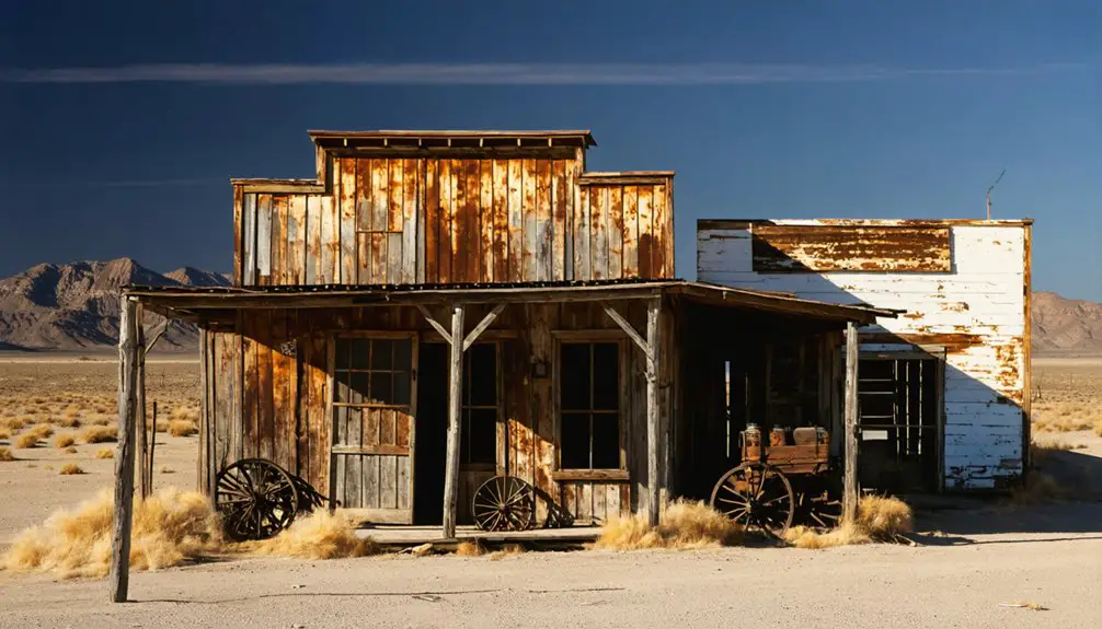
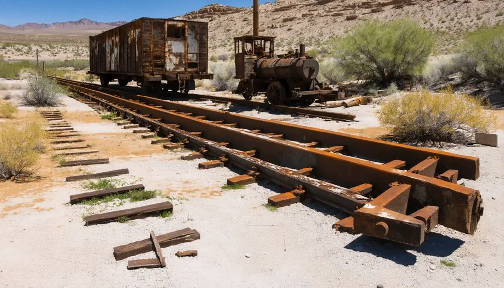
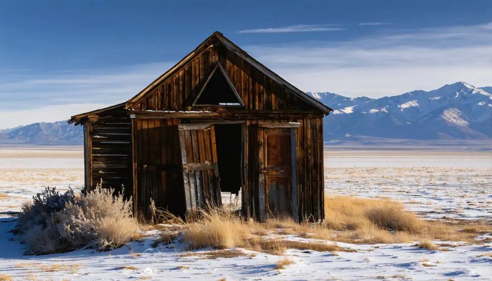
Today’s visitors to Jungo can explore the weathered remains of what was once a bustling mining community with over 50 framed houses and numerous businesses.
You’ll find stark evidence of architectural decay throughout the site, though Nevada’s arid climate has helped preserve many historical structures.
- Sawtooth Mill stands as a reflection of the town’s mining heritage
- Hidden rocked-in outbuildings reveal secrets of past inhabitants
- Rusting mining equipment scattered across the landscape tells technological tales
- Mine tunnels and shafts offer glimpses into dangerous underground workings
- Remnants of claim layouts map the town’s historical significance
While many wooden structures have succumbed to time, you can still discover roofless buildings, mill ruins, and mining infrastructure that paint a vivid picture of early 20th-century frontier life.
Seasonal Challenges and Access Tips
Accessing Jungo’s historic ruins demands careful planning across Nevada’s challenging seasons.
You’ll need serious winter preparation from late fall through early spring, as temperatures plummet and snow can block the unpaved Jungo Road. Pack insulated gear and snowshoes during these months to combat hypothermia risks.
Travel safety becomes critical on the 100-mile dirt route, where you’ll face rough terrain requiring 4WD vehicles.
Rough, remote terrain makes 4WD vehicles essential for navigating the challenging 100-mile dirt road to Jungo’s ruins.
Don’t attempt the journey alone – bring a travel companion and maintain reliable communication devices, as cell service is sparse. Stock up on water, food, and season-appropriate gear before departure.
During warmer months, watch for rattlesnakes while exploring the ruins. Spring and summer offer easier access but expect dustier conditions and increased traffic.
Consider GPS navigation, as road signage is minimal throughout the area.
Ghost Town Exploration Guide
When exploring the ruins of Jungo’s ghost town, you’ll discover a rich tapestry of Nevada’s mining heritage through carefully preserved structures and artifacts from the late 1920s.
Your ghost town photography opportunities showcase the raw spirit of this mining community, from sawtooth mills to rock-lined dwellings with hidden tunnels.
- Venture through weathered mining claims that tell stories of gold and silver rushes
- Document abandoned business remnants that once served ambitious prospectors
- Examine original mining artifacts scattered throughout the desert landscape
- Explore the network of historic roads that connected these frontier settlements
- Capture the essence of pioneer life through remaining wooden structures
Walk these grounds with respect, as each mining artifact represents a piece of Nevada’s bold and adventurous past.
Remember to check access permissions and stay alert for hazards while investigating these historic treasures.
Frequently Asked Questions
Are There Any Known Paranormal Activities Reported in Jungo?
75% of ghost sightings in Jungo aren’t documented, but you’ll find reports of rifle-wielding figures in windows, mysterious mining spirits, and unexplained sounds that’ve drawn multiple paranormal investigations to abandoned buildings.
What Wildlife Can Visitors Commonly Encounter Around the Jungo Ghost Town?
You’ll spot diverse desert wildlife including wild horses, coyotes, and jackrabbits roaming freely. Local fauna features raptors soaring overhead, while lizards and snakes navigate the rugged terrain around you.
Is Metal Detecting or Artifact Collecting Allowed at Jungo’s Ruins?
You can’t legally metal detect or collect artifacts here without proper permits. Metal detecting regulations and artifact preservation laws strictly protect sites over 100 years old in Nevada’s ghost towns.
Are Camping and Overnight Stays Permitted Near the Ghost Town?
While 97% of Nevada’s public lands allow camping, you’ll need to set up away from the protected ruins. No explicit overnight permits exist, but follow standard camping regulations and fire restrictions.
Were There Any Notable Crimes or Shootouts During Jungo’s Active Years?
You won’t find any documented Jungo crime history or shootout incidents in historical records. Unlike other Nevada ghost towns, Jungo’s story focuses purely on mining operations and tunneling work.
References
- https://nevadamagazine.com/issue/january-february-2016/3009/
- https://www.youtube.com/watch?v=znYWZIDO6bA
- https://nvtami.com/2021/07/24/jungo-road-jumble/
- https://nevadamagazine.com/issue/winter-2024-2025/25048/
- https://travelnevada.com/ghost-town/
- https://en.wikipedia.org/wiki/List_of_ghost_towns_in_Nevada
- https://davenkathy.blogspot.com/2019/04/history-rocks-in-winnemucca.html
- https://wiki.blackrockdesert.org/wiki/Jungo
- https://en.wikipedia.org/wiki/Nevada_State_Route_49
- https://nvtami.com/nevada-ghost-towns-map/


