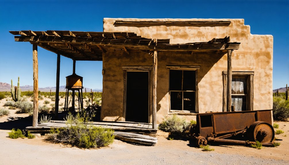
Kentucky Camp is a preserved ghost town in Arizona’s Santa Rita Mountains where an ambitious hydraulic gold mining operation ran from 1902-1912. You’ll find five remaining adobe structures, including a ten-room headquarters now available for overnight stays. The camp’s fortunes declined after founder James Stetson’s mysterious death in 1905. Today, it’s managed by the Forest Service and serves as a historic waypoint on the Arizona Trail, offering you a tangible connection to Arizona’s mining past.
Key Takeaways
- Kentucky Camp is a preserved ghost town established in 1902 as headquarters for the Santa Rita Water & Mining Company’s hydraulic mining operation.
- Five adobe structures remain, including a ten-room headquarters building that showcases southwestern architectural styles of the early 1900s.
- The mining venture collapsed after founder George Stetson’s mysterious death in 1905, having invested $200,000 but recovering only $2,000 in gold.
- The U.S. Forest Service acquired Kentucky Camp in 1989, preserving it as a historic site on the Arizona Trail.
- Visitors can explore the ghost town’s history and even stay overnight in the restored buildings through the “Rooms with a View” program.
The Birth of a Mining Settlement in the Santa Rita Mountains
When placer gold was discovered on the eastern slopes of the Santa Rita Mountains in 1874 by a prospector named Smith, it triggered a modest gold rush that would establish one of southern Arizona’s significant mining districts.
You’d find the Greaterville Mining District quickly recognized as having the richest placer deposits in Southern Arizona. Fred Hughes established Kentucky Gulch claims in 1875 before founding Greaterville.
The settlement grew from 80 Americans plus Mexican and Indigenous miners to over 400 residents within years. The mining community was named after Kentucky Gulch, one of the area’s richest placer deposits.
Mining techniques relied on gravity separation for placers, but water management posed significant challenges. Miners transported water in canvas and goatskin bags on burros or hauled ore to distant streams—an inefficient system that ultimately limited operations until the late 1880s when rich deposits were exhausted. The town’s initial success was bolstered by its access to water, proximity to a railroad, and the abundance of valuable ore in the surrounding area.
Gold Rush and the Greaterville Mining District
If you visit Greaterville today, you’d be standing where A. Smith discovered placer gold in 1874, initiating a rush that ultimately yielded over 29,000 ounces of gold from numerous gulches including Empire, Chispa, and Colorado.
The Santa Rita Water & Mining Company, under the direction of James Burgess Stetson, attempted to revolutionize extraction methods in 1900 by installing an eight-mile pipeline to enable hydraulic mining operations. During Greaterville’s peak, miners could extract up to one ounce per day using simple techniques despite water scarcity challenges.
The area maintained a modest but stable population of 129 by the 1910 Census, with residents primarily of Mexican descent working in mines and nearby cattle ranches.
Despite these innovative efforts and later attempts using dragline shovels and washing plants in 1948, no large-scale mining operation achieved sustained success in the gold-rich Greaterville placers.
Golden Discovery Timeline
The discovery of placer gold by A. Smith in 1874 sparked the formation of the Greaterville community in the Santa Rita Mountains. This discovery established the foundation for continued mining operations throughout the region, with early miners employing rudimentary techniques like rocker boxes to extract valuable nuggets worth $1 to $5 each.
During this golden era, you’d have witnessed:
- Miners extracting nuggets from the lower two feet of gravel, where gold concentrated in natural riffles.
- The community growing to 129 residents by 1910, primarily of Mexican descent, with placer mining driving the local economy.
- Evolution of extraction methods from individual prospectors to larger company operations, particularly the Santa Rita Water & Mining Company’s control of 3,000 acres.
One notably impressive find during the early mining period was a 37-ounce nugget that exemplified the potential wealth hidden in the Greaterville placers.
By the 1870s, the Greaterville Mining District had become a significant producer with an estimated 18,500 oz. of placer gold recovered from its numerous operations.
Hydraulic Mining Operations
Facing depleted surface deposits and diminishing returns from traditional methods, miners in the Greaterville district pivoted to hydraulic mining around 1886. The Stetson Company established operations in Kentucky Gulch, representing a technological advancement over earlier rocker methods that had exhausted accessible gravels by 1881.
Water management proved essential to this shift. Previously, Mexican laborers transported water from Gardner Canyon in goatskin bags, charging 25 cents per burro load of 10-16 gallons. To overcome this inefficiency, the Santa Rita Water and Mining Company formed specifically to develop water infrastructure, establishing Kentucky Camp as its headquarters. In 1902, the company proposed an ambitious water pipeline project to increase mining efficiency in the water-scarce Sanorita mountains.
Despite significant investment in these advanced mining techniques, hydraulic operations lasted only a few months before ceasing around 1900, marking another chapter in the district’s boom-and-bust cycle that had yielded over 29,000 ounces of gold.
The Rise and Fall of Kentucky Camp (1902-1912)
When you explore Kentucky Camp’s brief ten-year existence, you’ll find a fascinating tale of ambition that began with James Stetson’s hydraulic mining venture in 1902 and George McAneny’s financial backing.
Stetson’s mysterious death in May 1905—falling from a third-story hotel window under unclear circumstances—marked the beginning of the end for the operation. The Santa Rita Water & Mining Company’s headquarters buildings remain as adobe structures that tell the story of this short-lived gold rush enterprise. The venture had struggled to maintain profitability as the easily accessible gold became depleted, ultimately returning only about $3,000 to investors.
Hydraulic Mining Dreams
After gold was discovered near Greaterville in 1874, Kentucky Camp initially thrived as part of a regional mining boom that attracted over 500 miners to the area’s rich placer deposits.
By the late 1880s, these deposits were largely exhausted, but in 1902, the Santa Rita Water & Mining Company aimed to revive the area through advanced hydraulic mining techniques.
Under James Stetson’s engineering vision, they constructed:
- An elaborate aqueduct system channeling water from Bear Spring through ditches and tunnels
- Massive steel pipes (15 and 24 inches in diameter) creating the necessary water pressure
- Powerful hydraulic monitors capable of blasting hillsides with water streams reaching over 100 feet
Miners had previously relied on picks and shovels for small-scale operations before the aqueduct system was built.
Despite impressive hydraulic engineering achievements, their $200,000 investment yielded only $2,000 in gold during the initial six-week test run.
Stetson’s death in 1905 marked the beginning of the end for this ambitious venture.
Stetson’s Mysterious Death
The mysterious death of James Stetson in 1905 marked a fatal turning point for Kentucky Camp‘s ambitious mining revival.
On May 20, Stetson fell from Room 319 of Tucson’s Santa Rita Hotel under mysterious circumstances. The incident occurred around 3:00 PM, with a maid cleaning below providing one of the only eyewitness accounts of his body striking the window sill before landing on the cement sidewalk.
Despite an official inquest ruling death by brain concussion, questions lingered—was he pushed, did he jump, or did he accidentally fall? His bruised hands and cut foot offered few clues.
With no skull fracture and conflicting reports about his health, the truth remained elusive. The timing—just before a vital board meeting—proved devastating for Kentucky Camp, which was abandoned by 1912.
Financial Collapse Timeline
Founded with ambitious mining aspirations in 1902, the Santa Rita Water & Mining Company experienced a meteoric rise and devastating fall over a single decade. Following Stetson’s unexpected death in May 1905, the company’s operations rapidly deteriorated amid financial mismanagement and operational challenges.
Without its technical visionary, the venture couldn’t sustain itself despite early infrastructure successes.
- By 1906, creditors forced a sheriff’s auction, selling off the company’s water rights, equipment, and buildings—assets representing thousands in unrealized potential.
- New owners showed little interest in continuing the hydraulic mining operations, pivoting to cattle ranching instead.
- Kentucky Camp’s population dwindled precipitously, transforming from bustling headquarters to virtual ghost town by 1912.
The company’s demise mirrors many boom-and-bust cycles in Western mining ventures where vision outpaced practical realities.
The Mysterious Death of James Stetson
On May 20, 1905, mining engineer James Stetson plunged to his death from a third-story window of the Santa Rita Hotel in Tucson, Arizona, creating one of the most enduring mysteries in Arizona mining history.
The reserved engineer, who wasn’t prone to drunkenness or suicide, died just one day before an essential stockholders’ meeting where he planned to present $3,000 in gold samples proving the mine’s potential.
The timing couldn’t have been more suspicious.
Though a coroner ruled death by brain concussion from the fall, questions remain unanswered—did he fall, jump, or was he pushed?
The consequences were devastating: the Santa Rita Water & Mining Company collapsed, primary investor George McAneny lost his fortune, and Kentucky Camp’s promising mining operation ended within a year.
Hydraulic Mining Operations and Technology
While Stetson’s death abruptly halted the Santa Rita Water & Mining Company’s operations, the hydraulic mining technology at Kentucky Camp represented state-of-the-art engineering for its time.
The ambitious gold extraction system diverted water from the Santa Rita Mountains through canvas hoses to powerful iron nozzles called “monitors.” These monitors blasted hillsides with tremendous force, processing vastly more material than traditional placer mining methods.
The environmental consequences were substantial:
- Entire hillsides washed away, creating deep gullies and permanently altering the landscape
- Massive sediment deposits choked downstream waterways, destroying riparian habitats
- Water diversion disrupted natural flow patterns, affecting ecosystems throughout the watershed
Unlike California’s operations, Arizona’s hydraulic mining ventures required substantial capital investment, attracting Eastern financiers and transforming individual prospecting into corporate enterprise—a fundamental shift in Arizona’s mining economy.
Architectural Remnants: Adobe Buildings That Survived Time

Despite the collapse of mining operations after Stetson’s death, Kentucky Camp‘s adobe structures have endured the harsh desert conditions for over a century, providing a rare glimpse into early 20th-century mining architecture.
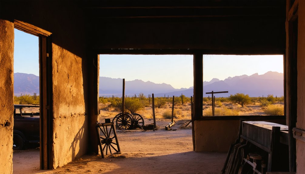
Five buildings remain: the impressive ten-room headquarters, two cabins, an assay office, and barn remnants, each representing the site’s cultural significance through different periods.
The adobe construction follows traditional Southwestern architectural styles, with thick walls providing natural insulation.
By 1989, these structures were deteriorating until the Forest Service initiated preservation efforts with experts from across the region.
Today, you’ll find the headquarters and a three-room cabin available for overnight stays through the “Rooms with a View” program, allowing you to experience this historic landscape intimately.
From Mining Camp to Cattle Ranch: The Transition Years
After the sudden collapse of Kentucky Camp’s mining enterprise in 1906 following James Stetson’s untimely death, the once-bustling headquarters underwent a remarkable transformation.
Attorney Louis Hummel acquired the property in 1911, converting it into a working cattle ranch that would sustain the site for the next fifty years. This shift to ranching heritage preserved the historic structures while adapting them for agricultural purposes.
As you explore Kentucky Camp today, you’ll notice:
- The 10-room adobe office building that was repurposed as the ranching family’s residence
- Ranch-specific modifications that showcase the adaptive reuse of industrial infrastructure
- Evidence of sustainable land management practices that maintained economic sustainability where mining failed
The Fenter family’s stewardship lasted until the mid-1960s, when failing eyesight forced the final cattle roundup, ending an era that had saved this historic site from abandonment.
Archaeological Discoveries and Daily Life at Kentucky Camp
When you explore Kentucky Camp’s archaeological record, you’ll find mining equipment remnants scattered across the site, including parts of the hydraulic systems that once channeled water from the reservoir to process gold.
The domestic artifact patterns reveal distinct spatial organization between administrative, residential, and work areas, with higher concentrations of personal items near the five adobe structures that served as company headquarters.
Analysis of food remnants indicates a surprisingly varied diet for frontier miners, suggesting both local procurement and imported goods sustained the workforce of 40 to 100 men who operated this ambitious mining venture.
Uncovered Mining Equipment
Archaeological excavations at Kentucky Camp have unearthed a treasure trove of mining equipment that offers rare insights into early 20th century hydraulic mining operations.
The site reveals sophisticated mining machinery designed to extract placer deposits using water pressurized to an impressive 1,000 psi. You’ll find remnants of the water delivery system throughout Boston Gulch, with gate valves and air-bleed valves still visible on the western ridge.
- Asphalt-lined pipe segments with compression fittings that minimized leakage while delivering water to multiple mining pits
- Hydraulic equipment strategically positioned across Boston, Kentucky, and Empire Gulches for simultaneous operations
- Specialized water distribution components including pressure regulators and 1-inch delivery pipes to the Kentucky Camp cistern
The gold processing building stands as evidence to the site’s original purpose, while the assay office once analyzed extracted gold.
Domestic Artifact Patterns
Scattered throughout Kentucky Camp’s dusty grounds, domestic artifacts tell a rich story of daily life during the site’s golden era. You’ll find evidence of surprising domestic comforts in the remnants of ceramic dishware, metal utensils, and personal grooming items that miners and their families once used.
The artifact significance extends beyond mere objects—they reveal social patterns and living arrangements. Multiple-room adobe structures with distinct functional spaces suggest residents maintained ordered domestic lives despite harsh conditions.
Personal items like jewelry fragments, buttons, and children’s toys indicate that families, not just lone miners, populated the camp. The distribution of food preparation tools shows meals were prepared in homes rather than communal spaces, while tobacco pipes and gaming pieces point to leisure activities that brought humanity to this remote settlement.
Food Remnants Analysis
Excavations at Kentucky Camp have yielded remarkable food remnants that provide a window into residents’ daily sustenance practices.
Archaeological evidence reveals a mining diet balanced between imported provisions and locally sourced foods. You’ll notice how the adobe structures served dual purposes—shelter and food preservation chambers—keeping perishables cool in Arizona’s unforgiving heat.
Three striking discoveries include:
- Animal bone fragments showing precise butchering techniques for maximizing nutrition from limited meat supplies
- Glass bottle remnants still bearing faded labels from Tucson suppliers who provisioned the remote camp
- Charred seed deposits indicating grain storage practices designed to thwart persistent desert rodents
Root cellars and underground storage areas proved essential for food preservation, while artifacts show mining workers required high-calorie meals to sustain their grueling hydraulic operations in the Santa Rita Mountains.
Preservation Efforts by the U.S. Forest Service and Volunteers
When the U.S. Forest Service acquired Kentucky Camp in 1989, they faced an urgent preservation challenge. Four remaining adobe buildings stood at risk of collapse, with one structure already lost.
The Coronado National Forest immediately contracted Ryden and Associates to analyze the historic buildings and create a stabilization plan.
Recognizing the urgent need for preservation, experts were quickly enlisted to assess and plan the rescue of Kentucky Camp’s historic structures.
By 1992, Forest Service archaeologists gathered at the site to practice restoration techniques like rebuilding walls, patching adobe, and applying sacrificial mud caps.
The Friends of Kentucky Camp, established in 1995, formalized volunteer engagement through regular work days and maintenance projects. Their efforts have successfully preserved the ten-room headquarters building and other century-old structures.
Today, you can experience this preserved mining history firsthand. One three-room adobe building even offers overnight stays through the Forest Service’s “Rooms with a View” program.
Hiking the Arizona Trail: Kentucky Camp as a Historic Waypoint
Nestled along the historic Arizona Trail, Kentucky Camp offers hikers a unique opportunity to step back in time while traversing the rugged Santa Rita Mountains in Pima County.
This segment of the trail, connecting Mexico to Utah, showcases both the natural beauty of southern Arizona and the historical significance of early 20th-century mining operations.
You’ll experience:
- Moderate elevation changes (5,446 to 4,986 feet) with sweeping views of Gardner Canyon’s rolling hills
- Well-preserved adobe buildings including a ten-room headquarters that earned National Register status in 1995
- Multi-use recreational opportunities including hiking, mountain biking, and horseback riding along diverse terrain
The 7.5-mile round trip from Kentucky Camp to Gardner Canyon Trailhead provides freedom to explore both pristine wilderness and tangible remnants of Arizona’s gold mining past.
Frequently Asked Questions
Are There Any Reported Ghost Sightings at Kentucky Camp?
You’ll find ghost encounters at Stetson’s cabin, where paranormal activity includes mining sounds, pickaxe noises, and an eerie miner’s whistle. Several ghost-hunters have documented these supernatural phenomena during overnight investigations.
The history of Klondyke Arizona ghost town adds an intriguing layer to the legends of the area. Once a bustling mining hub, the town now lies in ruins, its stories preserved through the whispers of the past. Visitors often leave with a sense of unease, captivated by the haunting tales that echo through its abandoned streets.
Can Visitors Pan for Gold Near Kentucky Camp Today?
You can’t pan for gold within Kentucky Camp itself, but with proper permits from Coronado National Forest, you’re free to try historic mining techniques in nearby Greaterville Mining District.
What Wildlife Can Be Observed Around the Kentucky Camp Area?
Like hikers on a treasure hunt, you’ll find remarkable wildlife diversity around Kentucky Camp. You can spot deer, javelinas, bears, and exceptional birdwatching opportunities with over 256 documented avian species inhabiting this freedom-rich landscape.
When Is the Best Season to Visit Kentucky Camp?
Fall and spring offer you the best weather for exploring Kentucky Camp, with moderate 70-85°F temperatures, minimal crowds, and ideal trail conditions. Seasonal events coincide with these comfortable, liberating months.
How Much Water Was Needed for the Hydraulic Mining Operations?
Parched earth meets industrial thirst. You’ll find the operation’s water consumption required thousands of gallons, stored in Stetson’s Dam to sustain mining efficiency across ten months during seasonal dry periods.
References
- https://pcttrailsidereader.com/post/728367010726215680/the-ghosts-of-kentucky-camp
- https://kids.kiddle.co/Kentucky_Camp
- https://www.archaeologysouthwest.org/pdf/ait/arch-tuc-v7-no4.pdf
- https://southernarizonaguide.com/kentucky-camp-az-a-ghost-town-with-accommodations/
- https://en.wikipedia.org/wiki/Kentucky_Camp
- https://www.gvrhc.org/Library/KentuckyCamp.pdf
- https://azoffroad.net/kentucky-camp
- https://www.youtube.com/watch?v=cTyoRTu9-GI
- https://4girlsandaghost.wordpress.com/2010/04/17/kentucky-camp-tragedy/
- https://www.kentuckycamp.org/kc_timeline.html


