Kern River Slough, originally known as Whiskey Flat, was a thriving gold rush settlement established in 1860 by Adam Hamilton. The community flourished until the 1953 Isabella Dam project submerged it beneath Lake Isabella. During severe drought periods, the town’s foundations—including the Methodist church, jail, and general store—emerge from the receding waters. You’ll discover a remarkable underwater archaeological site that periodically reveals itself as a temporal palimpsest of California’s frontier past.
Key Takeaways
- Old Kernville (formerly Whiskey Flat) was submerged in 1953 during the Isabella Dam construction project.
- Drought conditions have exposed foundations of Old Kernville’s church, jail, general store, and schoolhouse.
- The gold rush town originated in the 1860s after Lovely Rogers discovered gold in Greenhorn Gulch.
- Approximately 35,000 miners transformed the valley into a frontier community with the Big Blue Gold Mine.
- Receding waters at Lake Isabella reveal architectural remnants that are now being documented with modern technology.
The Gold Rush Origins of Whiskey Flat (1860-1864)
Gold fever swept through California’s Kern River Valley in the early 1860s, setting off a chain of events that would give rise to the settlement of Whiskey Flat. Following Lovely Rogers’ gold discovery in Greenhorn Gulch, Adam Hamilton established the settlement in late 1860, creating a makeshift saloon from whiskey barrels that gave the town its distinctive name.
As news spread, approximately 35,000 miners flooded the valley, transforming the landscape overnight. The Big Blue Gold Mine became the economic centerpiece of this burgeoning community. The area maintained its rough-and-tumble atmosphere typical of mining towns throughout the gold rush period.
Mining techniques evolved rapidly, with prospectors shifting from placer mining (pre-1855) to more complex lode mining operations. Today, the annual festival celebrates this rich historical legacy, educating visitors about the town’s gold mining era. Whiskey Flat emerged as one of several rowdy mining settlements that characterized Kern County’s contribution to California’s gold production—ultimately yielding more gold than any county south of the Mother Lode.
Life in Old Kernville: A Wild West Community
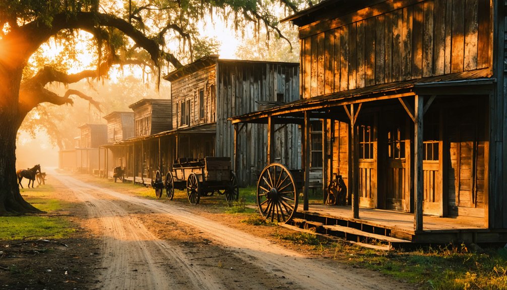
While Whiskey Flat’s origins lay in the feverish gold rush, the settlement that would become Old Kernville evolved into a fully-formed frontier community with distinctive social structures and cultural patterns.
The frontier economy balanced gold mining with agriculture, lumber production, and later, film industry opportunities. The town’s prominence as an Old West movie set attracted filmmakers looking for authentic frontier backdrops for their productions. Before the waters of Lake Isabella submerged it, Old Kernville served as the backdrop for over 200 movies, TV shows, and commercials. Residents navigated a precarious existence where law enforcement remained minimal—justice often dispensed through marshals or vigilante action.
Community events defined social life in this Wild West enclave:
- Saloons serving as improvised town halls where miners, ranchers, and merchants gathered
- Traveling shows and rodeos transforming the dusty main street into temporary entertainment venues
- Church gatherings and schoolhouse meetings establishing civilization’s foothold amid frontier rawness
The 1938 schoolhouse with indoor plumbing symbolized the gradual modernization of this resilient settlement.
The Isabella Dam Project and Forced Relocation
As devastating floods repeatedly ravaged the Kern River Valley throughout the early twentieth century, federal authorities conceived a solution that would permanently alter the region’s landscape and community fabric.
The 1944 Flood Control Act authorized Isabella Dam‘s construction, which commenced in 1948 at a cost of $22 million.
You’d scarcely recognize the valley after this massive infrastructure project. The dam construction submerged entire communities—old Kernville and Isabella disappeared beneath rising waters, forcing residents into sudden, mandatory displacement.
Imagine the shock when locals learned their generational homes would vanish underwater.
The dam’s functionality was clearly proven in 1966 when it successfully regulated water flow during exceptionally high levels, preventing potential downstream disasters.
This $305 million project (in today’s dollars) created Lake Isabella’s 570,000 acre-feet reservoir, effectively ending catastrophic downstream flooding while simultaneously erasing the original settled communities from the map—a governmental solution that prioritized regional safety over individual autonomy.
The dam’s completion in March 1953 marked the official birth of Lake Isabella and the permanent drowning of these once-vibrant communities.
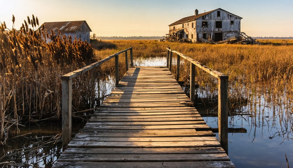
What Lies Beneath: Mapping the Submerged Town
You’ll encounter a methodical documentation process underway at Lake Isabella, where receding waters expose the architectural foundations of Old Kernville and Isabella.
GPS technology and 360-degree cameras now capture these submerged historical structures at Rocky Point, preserving visual evidence of settlement patterns that predate the 1953 flooding.
These mapping efforts, conducted through collaboration between local historical societies and preservation organizations, create a thorough archaeological record of the communities once hidden beneath the reservoir’s surface. With Lake Isabella currently at 8% capacity, researchers have unprecedented access to study the ghost town remains that are typically submerged. The mapping project utilizes volunteer support similar to the Kern River Parkway Foundation’s visual mapping initiative.
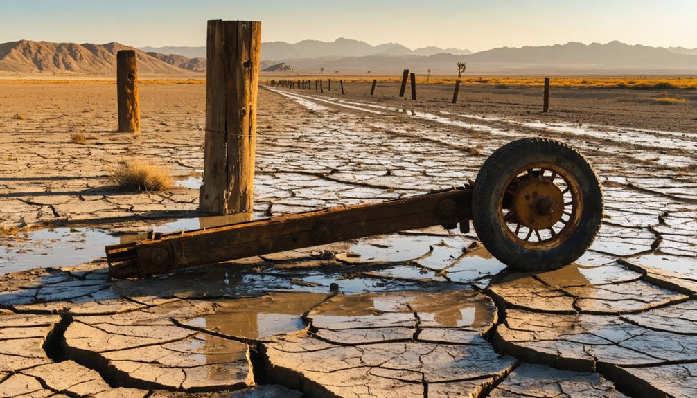
Foundations Reveal Past
Beneath the fluctuating waters of Lake Isabella lies a ghostly cartography of Old Kernville’s past, revealed during severe drought conditions that have periodically reduced the reservoir to as little as 8% of its capacity.
These abandoned structures hold tremendous historical significance, providing a rare glimpse into the architectural and social fabric of a 19th-century mining settlement.
As you traverse the exposed lakebed, you’ll encounter:
- The prominent 1898 Methodist church foundation, marking the community’s spiritual center
- Schoolhouse foundations revealing the educational priorities of frontier settlers
- Remnants of the jail and general store, indicating the civic and commercial heart
These drought-exposed foundations trace the town’s original layout, allowing researchers and visitors to reconstruct the spatial organization of this community that thrived before being sacrificed for water resource management in 1953. Originally founded in the 1860s after a gold discovery, the town represents one of many historical sites emerging due to climate change’s impact on water reserves. The town was previously known as Whiskey Flat before being renamed and eventually submerged when the U.S. Army Corps of Engineers dammed the Kern River.
Mapping Underwater Remnants
While Lake Isabella‘s receding waters periodically reveal the ghostly outlines of Old Kernville, modern archaeological techniques allow researchers to map and study the submerged town even when it lies hidden beneath the reservoir’s depths.
Underwater archaeology has revolutionized our understanding of these submerged structures through advanced sonar technology and side-scan systems that detect masonry foundations and artifacts otherwise invisible.
By integrating GPS and GIS data, scientists precisely map the town’s underwater footprint, creating three-dimensional models through photogrammetry despite challenging turbidity conditions.
You’ll appreciate how historical documentation complements these technological approaches—nineteenth-century canal maps and land surveys serve as reference points when analyzing contemporary sonar readings.
The Kern Canyon Fault‘s tectonic influence and subsequent river course changes further contextualize why these settlements now rest beneath the water’s surface rather than standing amid Kern River’s alluvial plains.
Drought Revelations: When the Ghost Town Resurfaces
You’ll find weathered foundations emerging from Lake Isabella‘s receding waters, telling stories of Old Kernville’s bygone era as drought transforms the reservoir into an archaeological exhibition.
California’s persistent water crisis has exposed over 36 miles of shoreline, revealing the dynamited remains of the 1898 Methodist church, jail, general store, and schoolhouse that haven’t seen daylight in nearly seven decades.
These drought-revealed ruins offer a fleeting window for photographers and historians to document tangible connections to the area’s gold rush heritage and Western film legacy before rising waters potentially reclaim them.
Exposed Foundations Reveal History
When extreme drought gripped California between 2014 and 2020, Lake Isabella’s water levels plummeted to a mere 8-16% of capacity, revealing the ghostly remnants of Old Kernville and Isabella that had remained submerged since 1953.
These architectural vestiges emerged from the desiccated lakebed like archaeological specimens, offering rare glimpses into the submerged history of these once-vibrant communities.
As you scan the exposed terrain, three distinct structural elements materialize:
- The weathered foundations of the 1898 Methodist church, rising from the dust
- Concrete footprints of the general store and jail, marking the town’s commercial center
- The old bridge spans, now skeletal frameworks stripped of their utility
These ghostly echoes of pre-reservoir life create a temporal palimpsest, simultaneously documenting both environmental crisis and historical preservation through catastrophe.
Drought’s Archaeological Window
California’s relentless six-year drought has transformed Lake Isabella into an unexpected archaeological site, where water levels plummeted from 580,000 acre-feet to a mere 95,000 acre-feet—reaching just 8% of capacity at its nadir.
This catastrophic water loss has created a rare archaeological window, revealing Whiskey Flat’s foundations—the schoolhouse, Methodist church, and other structures dynamited in the 1950s to create the reservoir.
You’ll find evidence of the town’s evolution from 1860s mining settlement to Hollywood Western backdrop, where Roy Rogers once filmed.
The drought implications extend beyond archaeological significance, as the exposed lakebed reveals the original Kern River canyon’s geological features, creating temporary wildlife habitats while marking environmental distress with a stark bathtub ring along the 36-mile shoreline—a sobering indication of climate change’s tangible impact.
Photographing The Past
The drought’s dramatic impact on Lake Isabella has created a photographer’s paradise of historical revelation, as Whiskey Flat’s skeletal remains emerge from the receding waters to tell their long-submerged story.
This rare convergence of environmental crisis and historic photography opportunity demands strategic technical preparation.
For ideal visual storytelling of this Gold Rush settlement, you’ll need:
- Wide-angle lenses to capture the 1898 Methodist church foundations against the bathtub ring marking former water levels
- Polarizing filters to reduce glare from the exposed lakebed while documenting the jail and general store remnants
- Dawn or dusk shooting schedules when raking light accentuates textural details of building foundations
Navigate carefully across unstable terrain as you document this fleeting archaeological window—the ephemeral intersection of drought-induced revelation and historical documentation before rising waters reclaim these dynamited structures once again.
Preserved Heritage: Relocated Buildings and Cultural Legacy
Preservation efforts in Kern River Slough represent a demonstration of the community’s determination to safeguard its historical infrastructure despite environmental challenges.
You’ll find numerous original structures that were physically relocated from flood-prone areas, including significant buildings from the Butterfield Overland Stage route. These cultural adaptations reflect practical responses to the Kern River’s unpredictable flooding patterns.
The historical significance of these preservation initiatives extends beyond mere buildings—they embody the pioneering spirit of early settlers like the Bohna family and showcase diverse cultural influences that shaped Kern County.
These heritage sites aren’t just structures—they’re living monuments to Kern County’s diverse pioneering legacy.
When exploring these relocated treasures, you’re witnessing tangible connections to early California frontier travel and the region’s hydrological innovations. These artifacts stand as powerful representations of the community’s resilience and adaptive heritage conservation strategies.
Visiting the Phantom Settlement: When and How
Precisely when can you witness the ghostly remains of Kern River Slough’s submerged settlements? Your ghost town exploration opportunities align with Lake Isabella’s drought cycles. For ideal viewing, monitor water levels—when capacity drops below 20% (approximately 116,000 acre-feet), significant structural remnants emerge from their watery vault.
The most rewarding visiting tips involve strategic timing:
- Track multi-year drought patterns through regional water authority reports
- Visit during late summer/fall when seasonal melt has subsided
- Explore Rocky Point for Isabella’s foundations and the original Whiskey Flat location for Old Kernville ruins
Extended drought periods offer the most thorough archaeological access, with water receding to reveal dynamited buildings’ foundations, bridge remnants, and the distinctive bathtub ring marking historical waterlines along canyon walls.
Frequently Asked Questions
Are There Underwater Archaeological Expeditions Exploring Old Kernville?
No documented underwater archaeological expeditions specifically target old Kernville. You’ll find historical preservation efforts focus on terrestrial sites, with underwater archaeology techniques primarily applied to California’s coastal regions instead.
Were Any Valuable Artifacts Recovered Before the Town’s Submergence?
Ever wonder what treasures lie forgotten? You’ll find no documented evidence of organized artifacts discovery before submergence. Historical records suggest residents prioritized relocating structures rather than engaging in systematic treasure hunting from condemned buildings.
Has Anyone Reported Paranormal Activity Around the Exposed Ruins?
You’ll find no academically documented ghost sightings at the exposed ruins. Local legends exist through informal resident testimonies, but paranormal activity lacks verification in historical archives or peer-reviewed investigations.
Did Any Residents Refuse to Leave During the Forced Relocation?
Historical records don’t document specific individuals refusing relocation at Kern River Slough, though town history suggests broader Indigenous resistance occurred through repeated returns to ancestral lands despite violent enforcement of removals.
How Has Climate Change Affected the Frequency of Old Kernville’s Reappearance?
While some might argue natural cycles are solely responsible, you’re witnessing climate impacts that have dramatically increased Old Kernville’s visibility frequency, inverting historical flooding patterns through intensified droughts that deplete Lake Isabella to unprecedented lows.
References
- https://www.latimes.com/archives/la-xpm-2004-oct-24-me-then24-story.html
- https://adventure.com/ghost-town-emerges-from-shrinking/
- https://www.sfgate.com/centralcoast/article/lake-isabella-ghost-town-emerges-17415393.php
- https://en.wikipedia.org/wiki/List_of_ghost_towns_in_California
- https://serc.carleton.edu/vignettes/collection/68165.html
- https://ohp.parks.ca.gov/?page_id=21423
- https://sierranevadageotourism.org/entries/old-kernville-aka-whiskey-flat-no-132-california-historical-landmark/47fdc6bd-f588-42ca-8e47-b6cb41839bc5
- https://www.kvpr.org/podcast/central-valley-roots/2025-08-21/the-towns-of-the-kern-river-gold-rush
- https://bakersfieldnow.com/news/local/kernvilles-whiskey-flat-days-a-blast-from-the-past-festival-unearthing-golden-history
- https://vinepair.com/booze-news/california-whiskey-flat-underwater/


