You’ll find Kilkenny Township nestled in New Hampshire’s White Mountain National Forest, a ghost town established in 1774 that never exceeded 27 inhabitants. Its rugged terrain, steep granite mountains, and dense forests made permanent settlement challenging. While the Upper Ammonoosuc Railroad briefly served logging operations, failed industrial ventures and harsh conditions led to its abandonment. Ancient mine carts, granite pillars, and the ruins of Saunders Mansion tell a deeper story of this wilderness frontier.
Key Takeaways
- Kilkenny Township, established in 1774, became a ghost town due to harsh terrain, economic challenges, and isolation within the White Mountains.
- The town’s population peaked at only 27 inhabitants in 1830 before declining, failing to sustain a permanent community.
- Failed industrial ventures, including logging operations and granite quarrying, contributed to Kilkenny’s abandonment and ghost town status.
- Historic remnants include stone walls, cellar holes, and industrial artifacts scattered throughout what is now White Mountain National Forest.
- Geographic isolation and lack of social institutions like churches and schools prevented sustainable settlement despite multiple development attempts.
The Birth of Kilkenny Township
While many New Hampshire townships were established in the mid-1700s, Kilkenny Township emerged on June 4, 1774, through a land grant issued to Jonathan Warner and his associates.
You’ll find the original grant encompassed a vast 26,911 acres of wilderness, reflecting the British colonial policy of encouraging settlement in remote areas. The township’s name draws directly from Kilkenny, Ireland, showcasing the cultural influences of early settlers’ heritage. Like its Irish namesake city which sits 60 meters above sea level, the township occupied elevated terrain.
Initially part of Grafton County, you’d see Kilkenny later reassigned to Coös County in 1803. Settler motivations were tested by the challenging terrain, as the land proved better suited for wildlife than farming.
The rugged landscape and limited infrastructure would ultimately shape Kilkenny’s destiny as one of New Hampshire’s most sparsely populated territories.
Geographic Layout and Natural Features
The rugged landscape that deterred early settlers has become Kilkenny Township’s defining characteristic. Situated within White Mountain National Forest, this uninhabited township showcases dramatic topographical features and diverse hydrological characteristics.
You’ll find yourself surrounded by granite-rich mountains, dense forest cover, and a network of seasonal streams. Like nearby Livermore ghost town, the area’s challenging terrain and harsh conditions eventually discouraged permanent settlement. The devastating major fires of the 1870s stripped away vegetation and caused significant erosion of the mountainside.
Four natural elements that make Kilkenny uniquely wild:
- Steep rocky ledges creating natural hazards and impressive vistas
- Water-filled quarry pits that’ve transformed into serene mountain pools
- Second-growth forests reclaiming abandoned settlement sites
- Natural watersheds carved by snowmelt and rain through mountain terrain
The township’s boundaries follow the national forest’s contours, creating a pristine wilderness where nature’s untamed spirit thrives free from human interference.
Early Settlement and Population Patterns
You’ll find Kilkenny’s origins in its 1774 land grant to Jonathan Warner and others, encompassing nearly 27,000 acres of challenging White Mountain terrain.
The town’s population peaked at just 27 inhabitants in 1830, with most settlers concentrated along the southern boundary where the land proved more manageable for farming.
The rugged landscape was primarily home to forest animals, including bears, wolves, and moose, making permanent settlement difficult.
Like Vermont’s Glastenbury Mountain, Kilkenny became associated with mysterious wilderness legends due to its remote, mountainous location.
Original Land Grant Details
Established through a colonial land grant on June 4, 1774, Kilkenny encompassed 26,911 acres of rugged New Hampshire wilderness granted to Jonathan Warner and associates.
Similar to how first settlers arrived in Cheshire County in 1736, the area that would become Kilkenny drew interest for its untamed frontier potential.
Named after the Irish town and county of Kilkenny, this colonial land grant came just before the American Revolution, marking one of the last territories allocated under British rule in the region. The area’s waterways were as significant as the nearby Jefferson River, which would later become an important navigational route.
You’ll discover these fascinating aspects of Kilkenny’s original grant:
- The township initially included large portions of what’s now eastern Jefferson
- The southern boundary shifted multiple times throughout the 19th century
- The grant incorporated untamed wilderness suited for bears, wolves, and moose
- By 1856, boundary adjustments had reduced the territory to 15,906 acres
The grant’s remote location and challenging terrain would ultimately shape its destiny as a sparsely populated frontier.
Population Growth Challenges
Despite its promising land grant status, Kilkenny struggled to attract and retain settlers throughout its early years, mirroring broader population challenges faced by New Hampshire’s frontier communities in the 1600s.
You’ll find that demographic stagnation was common, as early settlers faced numerous settlement difficulties including harsh environmental conditions and limited economic opportunities.
Like other frontier settlements, Kilkenny’s population growth was hindered by the lack of established social institutions and community support structures.
The settlement pattern followed the typical New Hampshire model, where commercial interests, rather than religious motives, drove initial settlement attempts.
Records show that by 1640, the total colonial population was only around 100 settlers across all New Hampshire settlements.
Without churches, schools, or strong governance, maintaining a stable population proved challenging.
The isolated location and economic instability further complicated efforts to build a thriving community, reflecting the broader struggles of early New Hampshire colonies.
The constant threat of attacks during King William’s War made many potential settlers hesitant to establish homes in frontier regions like Kilkenny.
Isolated Territory Impact
While many early New Hampshire settlements flourished along the coast and river valleys, Kilkenny’s extreme geographic isolation in the White Mountains greatly shaped its struggle to develop.
The harsh reality of settler experiences in this unforgiving terrain reveals why permanent communities couldn’t take root. Unlike successful coastal settlements like Strawbery Banke, which became a major population center, Kilkenny remained sparsely inhabited.
Consider these critical impacts of Kilkenny’s isolation:
- You’d face brutal winters and short growing seasons that made farming nearly impossible.
- You couldn’t rely on stable supply chains or communication routes due to the rugged mountain terrain.
- You’d find limited economic opportunities beyond basic logging, trapping, and subsistence farming.
- You’d encounter complex indigenous interactions, as the Abenaki maintained a longer presence in this remote buffer zone.
The township’s isolation ultimately led to its ghost town status, lacking the institutional development that sustained other New Hampshire settlements.
Land Area Changes Through Time
Originally granted in 1774 with 26,911 acres of rugged mountainous terrain, Kilkenny’s land area underwent significant changes throughout its history.
By 1856, you’d find the territory reduced to 15,906 acres, marking a substantial shift in boundary evolution. The land use patterns transformed as the southern border realigned with Jefferson and Lancaster towns in the 1870s, later extending to include Mount Waumbek and Pliny Mountain by 1896.
Kilkenny’s footprint shrank to 15,906 acres by 1856, before expanding south to embrace Mount Waumbek and Pliny Mountain.
You’ll notice these changes reflected in deeds mentioning the “Kilkenny Addition.” While a B&M railroad spur briefly crossed the land, and proposals like the 1971 Willard Bowl ski area emerged, the territory remained largely undeveloped.
Today, the entire township rests within White Mountain National Forest, preserving its wild character and ending further boundary adjustments.
Historical Transportation Routes
Since the late 1800s, Kilkenny’s transportation network centered primarily around its railroad infrastructure, with the Upper Ammonoosuc Railroad serving as the town’s essential logging artery from 1892 onward.
You’ll find that Kilkenny’s transportation evolution reflected the changing needs of its resource-based economy.
The area’s transportation development included:
- Primitive trails like the Upper Ammonoosuc, which carved paths through mountain passes near Priscilla Brook
- Early 1800s turnpike networks that enabled faster carriage travel before rail dominance
- Logging railroads that stretched 8-14 miles, connecting Berlin, Kilkenny, and Milan
- B&M railroad spurs reaching elevations of 2,100 feet near Mount Waumbek, supporting both logging and limited tourism
The Lost Trails of Kilkenny
As the wilderness of Kilkenny reclaimed its logging paths and railroad grades, a network of lost trails emerged that tells the story of this abandoned New Hampshire town.
You’ll find traces of the Upper Ammonoosuc Trail along Priscilla Brook, though lost navigation has made this historic path challenging to follow. The abandoned railroad spur near Garland Brook, which once climbed to 2,100 feet, vanished by 1935.
Today, you can explore the 22-mile Kilkenny Ridge Trail, but trail preservation remains an ongoing challenge.
The dense forest and rugged terrain often force you to bushwhack through areas where old paths have disappeared. While the Cohos Trail Association maintains newer routes, many historic trails exist only in old atlases, their remnants slowly fading into the wilderness.
Economic Challenges and Decline
You’ll find that Kilkenny’s economic trajectory was marked by limited industrial development, with attempts at establishing mills and logging operations failing to gain sustainable traction.
The town’s population never achieved significant growth due to its remote location and harsh environmental conditions that deterred permanent settlement.
Despite various attempts to establish viable businesses and attract residents, Kilkenny’s development initiatives consistently fell short, leading to its eventual abandonment and ghost town status.
Limited Industrial Development
The limited industrial development in Kilkenny, New Hampshire, stemmed from several interconnected challenges that ultimately contributed to the town’s decline. The town’s location within the White Mountain National Forest and challenging terrain created significant industrial limitations that prevented the establishment of major manufacturing facilities or transportation networks.
You’ll find these stark realities shaped Kilkenny’s economic stagnation:
- The region lacked the substantial timber baron investments that powered neighboring towns like Lincoln.
- By 1935, even the railroad spur was discontinued, severing crucial transport links.
- The modest $20,000 economic value reported in 1856 reflected minimal industrial activity.
- A sparse population couldn’t support a sustainable workforce for major industries.
These factors combined with natural resource constraints and regional economic shifts sealed Kilkenny’s industrial fate.
Population Never Grew
Limited industrial development wasn’t Kilkenny’s only struggle – population growth proved equally elusive throughout its brief inhabited history.
You’ll find the population dynamics were grim from the start, with only 27 residents recorded in 1830. Settlement obstacles included the harsh mountainous terrain of Pilot and Willard’s mountains, limited farmable land, and a lack of economic opportunities beyond sparse industry.
The township’s isolation and poverty created a perfect storm that prevented any meaningful population growth. Without schools, stores, or basic infrastructure, you wouldn’t find the essential amenities needed for community development.
The surrounding wilderness, better suited for bears and moose than human settlement, ultimately reclaimed Kilkenny. By the 20th century, the population had dwindled to zero, transforming this remote township into a certified ghost town.
Failed Development Attempts
Despite early prosperity from its granite quarrying operations, Kilkenny’s economy began an irreversible decline in the 1930s that would seal its fate as a ghost town.
You’ll find that numerous economic hurdles and failed initiatives contributed to Kilkenny’s downfall, ultimately leaving it abandoned.
The town’s attempts at economic survival faced these insurmountable challenges:
- The granite industry collapsed due to concrete’s rising popularity and depleted stone resources.
- Loss of the essential railroad spur in 1935 cut off critical transportation links.
- The Great Depression’s lingering effects weakened the town’s already fragile economy.
- A 1970s ski resort development plan (Willard Bowl) failed to materialize.
Without successful diversification beyond quarrying and faced with geographic isolation, Kilkenny couldn’t sustain itself as an economic hub, leading to its eventual abandonment.
Legacy in Maps and Documents
If you examine maps from different eras, you’ll discover the area’s transformation.
The 1896 topographic map shows railroad spurs, while the 1935 version reveals their removal and displays trails like the Upper Ammonoosuc.
Today’s maps place Kilkenny entirely within White Mountain National Forest, though abandoned trails still trace the paths of its past.
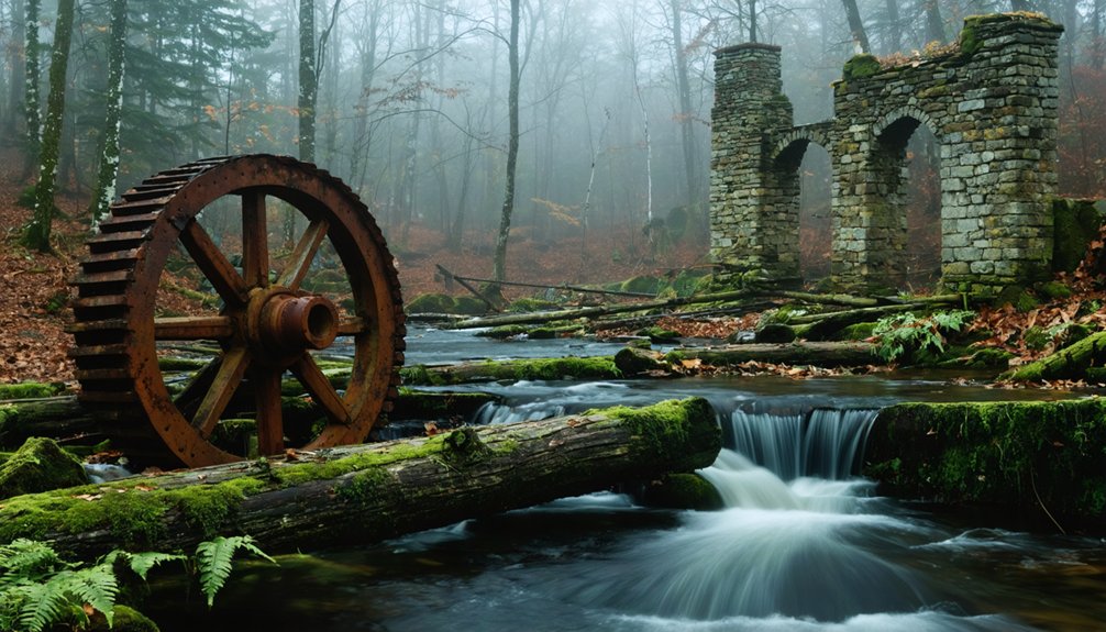
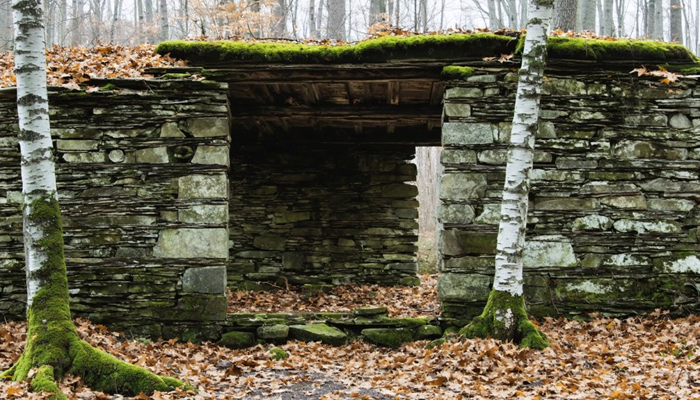
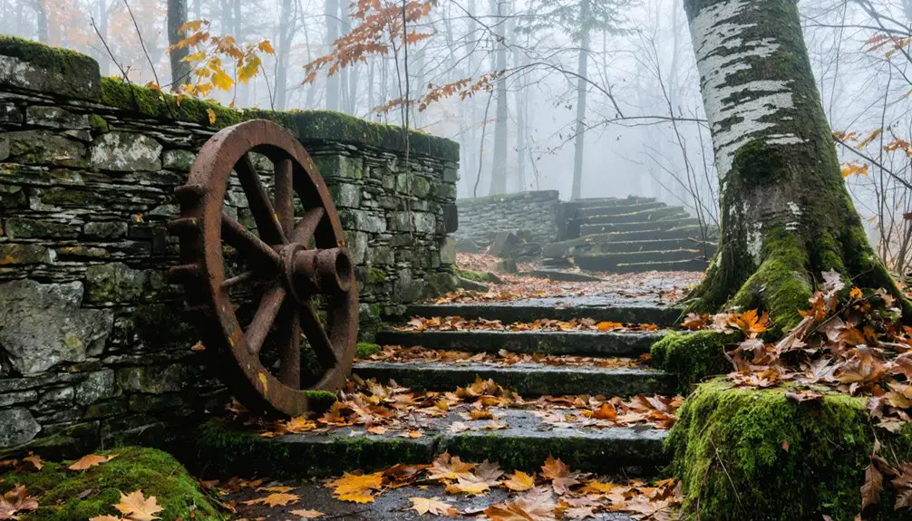
Notable Landmarks and Remnants
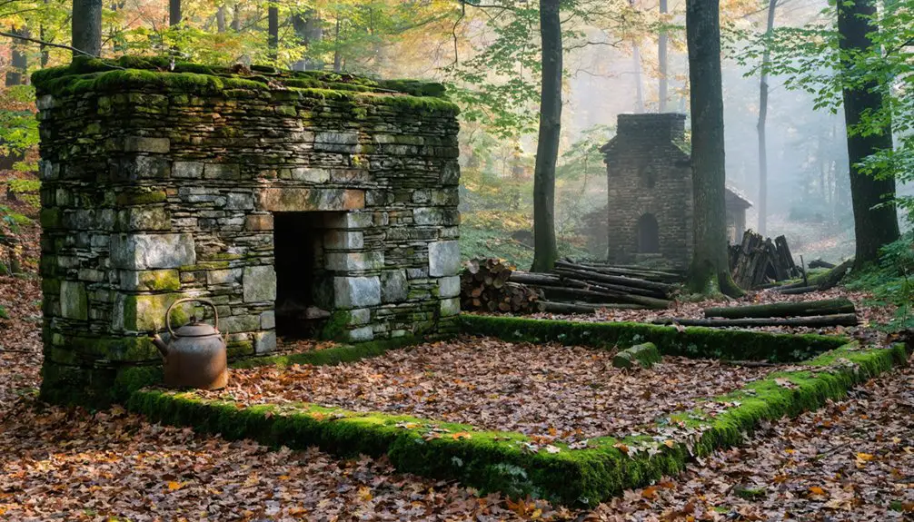
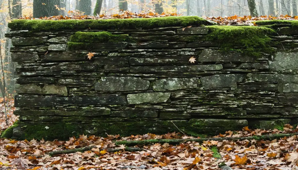
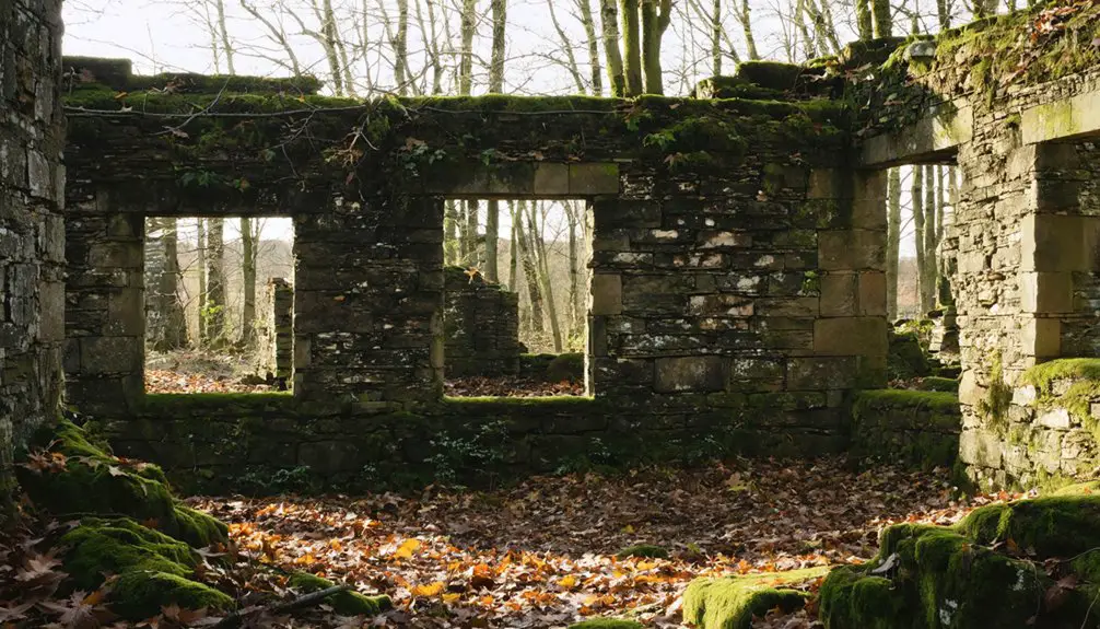
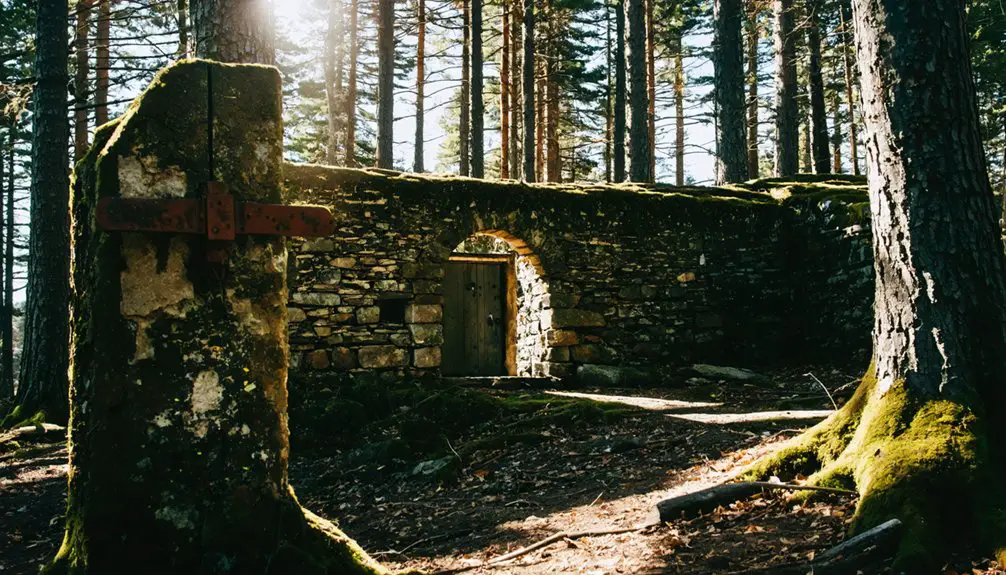
While nature slowly reclaims Kilkenny’s structures, significant remnants still tell the story of this once-bustling town.
You’ll find industrial remains scattered throughout the White Mountain National Forest, from moss-covered cement structures to rusted machinery parts submerged in old quarry pits.
Community foundations reveal the town’s layout, with stone walls and cellar holes marking where families once lived.
- The Saunders Mansion foundation, which stood until 1965, showcases the grandeur of Kilkenny’s past.
- Tall masonry stanchions on both sides of the river hint at former bridges and industrial might.
- The carpentry shop stands derelict but defiant against time’s march.
- Ancient mine carts and granite pillars dot the landscape, silent sentinels of the quarrying era.
Frequently Asked Questions
Why Was Kilkenny Named After an Irish Town and County?
You’ll find Irish heritage influenced town naming in 1774, as settlers and land grant recipients commonly named New England settlements after their ancestral places to maintain cultural connections with Ireland.
What Happened to the Original Settlers and Their Descendants?
You’ll find most settler migration scattered them to nearby prosperous towns – they couldn’t survive Kilkenny’s harsh conditions. Their descendant stories fade into surrounding communities, leaving no permanent family lines behind.
Are There Any Remaining Structures or Ruins in Kilkenny Today?
You’ll find a flooded quarry pit, remaining buildings like horse barns and a winch house, plus scattered historical artifacts from industrial operations. Some houses near the ghost town remain occupied.
Was Mining or Logging Ever Attempted in the Kilkenny Area?
You’ll find limited mining history in Kilkenny itself, though nearby areas had mines. Logging was definitely attempted, supported by rail infrastructure and forest roads through the White Mountain National Forest.
Can Visitors Legally Explore the Former Township Grounds Now?
You’re free to explore these ghost town grounds since they’re within White Mountain National Forest. Just follow visitor guidelines and Forest Service regulations while hiking through the remote wilderness.
as you continue your journey, you might find yourself exploring lignite’s historical landmarks, each telling a story of the past. The remnants of old mines and structures offer a glimpse into the region’s industrial heritage. Take your time to absorb the history and appreciate the natural beauty that surrounds these intriguing sites.
References
- https://www.visitwhitemountains.com/blog/post/spooky-stories-ghost-towns-and-historic-haunted-spots/
- https://newenglandhistoricalsociety.com/six-new-england-ghost-towns/
- https://en.wikipedia.org/wiki/Kilkenny
- https://www.wikiwand.com/en/articles/List_of_ghost_towns_in_New_Hampshire
- https://en.wikipedia.org/wiki/List_of_ghost_towns_in_New_Hampshire
- https://www.familysearch.org/en/wiki/Kilkenny
- https://en.wikipedia.org/wiki/Jefferson
- https://newenglandtowns.org/new-hampshire/kilkenny
- https://www.nhptv.org/kn/itv/ournh/ournhtg3.htm
- https://www.youtube.com/watch?v=rep3jOJt3nM