You’ll find Kreamer Island nestled near Belle Glade, Florida, where pioneering settlers established a thriving agricultural community in the late 1800s. The island featured a general store, post office, school, and church, with residents farming vegetables and fruits. In 1928, a catastrophic Category 4 hurricane devastated the settlement, claiming thousands of lives and forcing survivors to abandon their homes. Today, archaeological discoveries during drought periods reveal fascinating remnants of this lost community’s rich history.
Key Takeaways
- Kreamer Island, near Belle Glade, Florida, was once a thriving agricultural community with a general store, post office, school, and church.
- The catastrophic 1928 hurricane devastated the island with 150 mph winds and a 10-foot storm surge, leading to massive loss of life.
- Archaeological discoveries during the 2007 drought revealed building foundations, artifacts, and remnants of the abandoned 19th-century settlement.
- The island is now largely inaccessible, requiring airboats during wet seasons and only allowing RV access during drought conditions.
- The Herbert Hoover Dike’s construction altered drainage patterns and severed historical road connections, contributing to the island’s abandonment.
Early Settlement and Pioneer Life
While Hamilton Disston’s major land purchase in 1881 paved the way for settlement, Kreamer Island’s pioneering community didn’t take firm root until the U.S. Government’s official survey in 1917 opened the land for homesteading.
Despite Disston’s 1881 land deal, Kreamer Island’s true settlement began when the 1917 government survey enabled homesteading opportunities.
You’ll find that these early settlers faced significant pioneer struggles as they cleared dense stands of pond apple trees to create farmland in the fertile but challenging muck soils.
The island’s farmers worked hard in the custard apple muck soil along the lake’s southeast edges, which was enriched with minerals that boosted crop productivity.
The community thrived until devastating hurricane casualties in the 1920s drastically reduced the population.
As you explore the island’s agricultural development, you’ll discover how these determined pioneers established a diverse farming community, growing vegetables, sugarcane, bananas, grapefruit, and avocados.
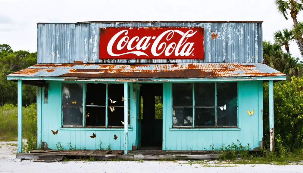
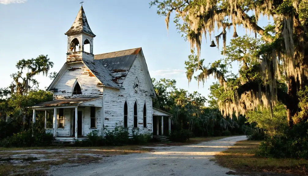
They built the essential infrastructure needed for daily life, including a general store, post office, school, and church.
Despite their remote location and reliance on boat transportation, they created a functioning society with regular town elections and community gatherings.
Geographic Features and Natural Landscape
As you venture into Lake Okeechobee‘s southeasternmost region, you’ll find Kreamer Island positioned at 26°45′24″N 80°44′00″W, approximately 4 miles northwest of Belle Glade.
The island’s wetland ecology features saw palmettos, scrub pines, and dense thickets typical of Florida’s lake basin environments. A small canal separates it from nearby Torry Island, while the Herbert Hoover Dike system has dramatically altered the area’s natural drainage patterns. Once a thriving community in the 19th century settlement, Kreamer Island was among the first populated areas around Lake Okeechobee. Environmental concerns emerged when thousands of tires were discovered scattered across the landscape during periods of low water levels.
The haunted history of Lake Fern is woven into the very fabric of the area’s lore, with tales of long-lost settlers and peculiar phenomena echoing through the wetlands. As visitors venture into this mysterious landscape, they often recount stories of inexplicable sounds and sightings that continue to capture the imagination. Such accounts add to the allure of the region, drawing in those intrigued by its past and the secrets it may still hold.
The terrain’s marshy character and low elevation make it prone to flooding, especially during hurricane seasons. You’ll need an airboat to access the island during wet periods, while vehicles can only reach it during significant droughts.
The surrounding landscape showcases the persistent influence of Lake Okeechobee’s water levels, with native plants quickly reclaiming any abandoned areas in this humid, tropical setting.
Transportation and Access Methods
Your access to Kreamer Island today depends heavily on seasonal conditions, with airboats being essential during wet periods and recreational vehicles possible only when lake levels are low.
This marks a significant change from the island’s early days when residents relied primarily on waterborne transportation via Lake Okeechobee’s waterways for moving people, supplies, and agricultural goods. CSX Transportation now offers cost-efficient shipping options through the region, though these rail services do not directly reach the island.
The construction of the Herbert Hoover Dike and subsequent environmental changes have eliminated most historical land routes, transforming what was once an accessible settlement into a location that’s now largely cut off from conventional transportation methods.
Historical Boat Travel
Because of Kreamer Island’s isolated geography, early settlers depended heavily on watercraft to navigate Lake Okeechobee’s challenging waters.
Boat navigation was particularly treacherous due to shallow shoals, oyster bars, and seasonal “northers” that limited water depth. You’d find small vessels, like shallow-draft boats, carefully maneuvering through natural passages like Gasparilla Pass, which only offered depths of 6.5 feet. The modern depth restrictions remain similar today, with vessels requiring a maximum 10-foot draft to traverse the waterway safely.
From January to May, you could catch daily steamers running between Ft. Myers and Punta Gorda, though service dropped to three times weekly in off-seasons.
Vessel technology evolved with the completion of various canals, including the North New River Canal and later the Okeechobee Waterway in 1937. These improvements transformed travel options, though seasonal water levels and environmental challenges continued to impact accessibility, often requiring adaptations between airboats and land vehicles.
Modern Access Challenges
Modern access to Kreamer Island presents a complex web of seasonal and environmental challenges that shape transportation methods throughout the year.
You’ll find airboats are your primary means of reaching the island during wet seasons when rising waters submerge the surrounding terrain. During droughts, you can navigate to the island using specialized off-road vehicles and RVs across exposed lakebeds, though these routes remain rough and unreliable. Visitors should note that motor boat navigation requires extra caution due to rocks and shallow water conditions. Being part of Lake Okeechobee, the largest lake in the southeastern United States, adds to the navigational complexity.
For adventurous travelers, kayaks and canoes offer an alternative way to reach the island, particularly during calm conditions.
However, access limitations stem from the complete absence of maintained roads or bridges connecting to the mainland. The Herbert Hoover Dike‘s construction severed historical road connections, leaving the island’s accessibility entirely dependent on seasonal variations and weather patterns.
Seasonal Transportation Routes
While seasonal changes dramatically reshape access routes to Kreamer Island throughout the year, two primary transportation methods have emerged to navigate its challenging terrain.
In wet seasons, you’ll need an airboat to traverse the flooded landscape, while dry periods allow for recreational vehicle access across exposed pathways and dikes. For safety reasons, visitors should check service alerts before attempting any travel to the island. The nearby Lake Okeechobee Trail offers an excellent vantage point to assess water conditions and plan routes.
Key aspects of seasonal navigation include:
- Airboats provide essential transport during high-water periods, operated by skilled pilots familiar with local hazards.
- RVs and off-road vehicles become viable during drought conditions when levee roads emerge.
- Transport logistics shift with Lake Okeechobee’s water levels, managed through flood control systems.
- Emergency access requires careful timing and specialized equipment based on seasonal conditions.
Your choice of transportation method must align with water levels and weather patterns to guarantee safe passage.
The Devastating 1928 Hurricane
As one of the deadliest natural disasters in U.S. history, the 1928 hurricane struck Palm Beach County with devastating Category 4 winds reaching 150 mph and dumped over 18 inches of rain in less than a day.
The storm surge breached Lake Okeechobee’s weak dikes, sending a 10-foot wall of water across communities up to 75 miles wide. You’d have witnessed floodwaters rising an inch per minute in Belle Glade, reaching depths of 7 feet.
Lake Okeechobee’s waters exploded through failing dikes, unleashing a terrifying 10-foot surge that devoured everything in its 75-mile path.
In the hurricane aftermath, 2,500 to 3,000 people perished, making it America’s second-deadliest hurricane. While some towns showed remarkable community resilience and rebuilt, Kreamer Island couldn’t recover.
The floods destroyed homes, crops, and essential infrastructure, leaving 15,000 families homeless across Palm Beach County and causing up to $50 million in damages.
Archaeological Discoveries and Artifacts
You’ll find some of Kreamer Island’s most significant archaeological discoveries emerged during the 2007 drought when receding lake waters exposed ancient artifacts in the lake bed.
The subsequent excavation by Palm Beach County revealed pottery shards, tools, and ceremonial items that pointed to a thriving indigenous settlement dating back over 1,000 years.
The artifacts, many linked to the Belle Glade culture and Calusa pottery traditions, showed evidence of fishing and hunting lifestyles while suggesting the inhabitants maintained extensive trade networks throughout Florida’s coastal and inland regions.
Drought Reveals Hidden Treasures
Once Lake Okeechobee‘s water levels plummeted during a severe drought in 2007, archaeologists gained unprecedented access to Kreamer Island’s submerged treasures.
Using specialized archaeological techniques, researchers uncovered remarkably preserved artifacts in the exposed lake bottom, revealing centuries of human history.
You’ll discover these fascinating drought artifacts that tell the story of life on Kreamer Island:
- Ancient wooden dugouts and canoes dating back 1,100 years
- Indigenous settlement remnants showing complex trade networks
- 19th-century fishing and agricultural tools preserved in lake muck
- Weedon Island culture artifacts connecting to broader Gulf Coast societies
The Palm Beach County Board of Commissioners seized this rare opportunity, launching formal investigations that winter.
Through careful excavation methods like coffer dams and controlled trenches, archaeologists preserved the delicate stratigraphy while recovering waterlogged treasures that had remained hidden for generations.
2007 Excavation Findings
Seven remarkable excavation findings emerged during the 2007 drought investigations of Kreamer Island, transforming our understanding of this Lake Okeechobee settlement.
You’ll find evidence of an ancient seagoing dugout canoe, carbon-dated to 1,100 years ago, alongside sophisticated stone and shell artifacts that reveal extensive trade networks.
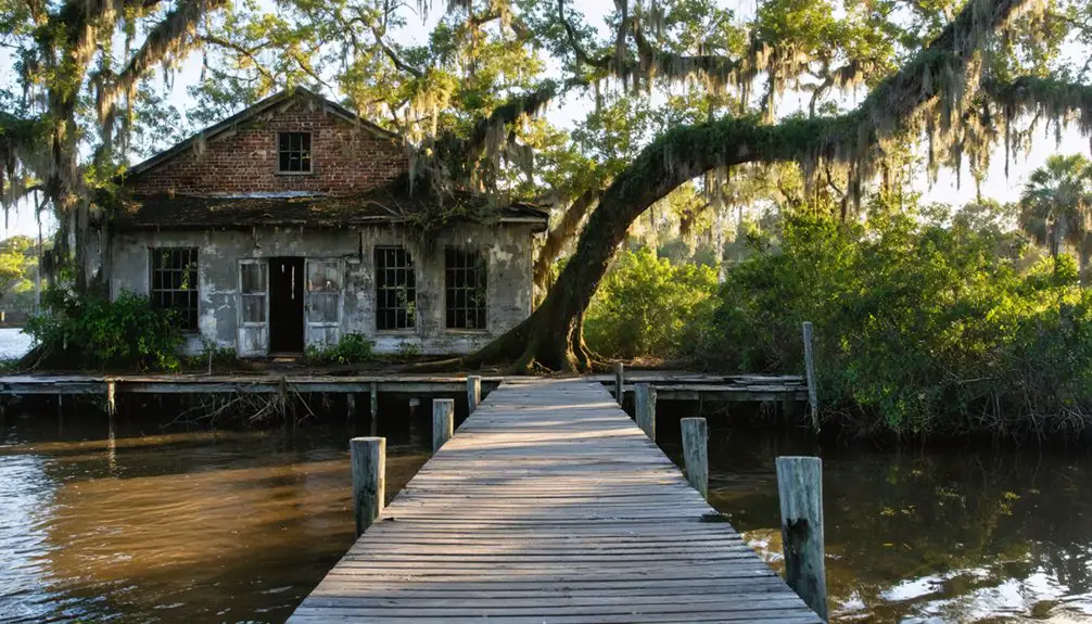
The excavation techniques revealed foundations of 19th-century buildings, including a multi-purpose structure that served as both church and store.
You’ll discover stone pendants, arrowheads, and pottery shards in the exposed lakebed, while soil analysis points to historical farming practices.
Perhaps most poignantly, artifact preservation efforts documented casualties from the devastating 1928 hurricane.
These findings paint a complex picture of Kreamer Island’s evolution from pre-Columbian maritime culture to its eventual abandonment.
Settlement Life Evidence
The archaeological record of Kreamer Island reveals a vibrant 19th-century fishing and agricultural community that flourished in Lake Okeechobee’s southeastern waters.
Settlement architecture included multiple dwellings, a church, and a schoolhouse, while community dynamics centered around a multi-purpose building that served as a home, post office, and general store.
You’ll find evidence of daily life through:
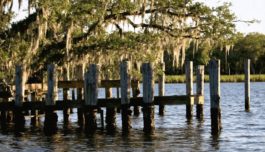
- Building foundations and pilings scattered among overgrown vegetation
- Preserved domestic artifacts exposed during drought conditions
- Historic roadways and grades visible in satellite imagery
- Cultural deposits beneath the lake’s waters
The island’s isolation, accessible only by boat or airboat, shaped its unique character until devastating hurricanes in the 1920s and raised lake levels ultimately led to its abandonment.
Herbert Hoover Dike’s Impact
Since its construction in the 1930s, Herbert Hoover Dike has served as an essential 143-mile earthen barrier around Lake Okeechobee, fundamentally transforming flood protection in South Florida.
You’ll find this massive structure, built in response to devastating hurricanes in 1926 and 1928 that killed thousands, now stands as a symbol of flood prevention engineering.
The dike’s recent rehabilitation, completed ahead of schedule with an $870 million investment, has made it stronger than ever before.
This massive engineering feat, finished early and reinforced with an $870 million upgrade, now stands as South Florida’s strongest defense.
The structure’s materials – including gravel, rock, limestone, and sand – required extensive engineering improvements like a partial cutoff wall to manage seepage.
Today, you’re witnessing the dike at its historic best, protecting communities like Moore Haven, Clewiston, and Belle Glade from the lake’s destructive potential.
Historical Significance in Florida
Located among Lake Okeechobee’s earliest settlements, Kreamer Island emerged as a notable 19th-century pioneer community that exemplified Florida’s frontier development.
The island’s cultural heritage represents a significant chapter in the state’s agricultural and rural history, though its story was tragically cut short by natural disasters.
You’ll discover these key elements of Kreamer Island’s historical significance:
- Established one of Florida’s earliest Lake Okeechobee farming communities, showcasing pioneer resilience
- Demonstrated traditional agricultural practices through family-operated farms growing beans and onions
- Served as a self-sufficient settlement with its own church, school, and post office
- Provides archaeological insights for historical preservation, revealed during periodic lake droughts
The island’s ultimate abandonment following the 1928 hurricane marked the end of an important era in Florida’s settlement history.
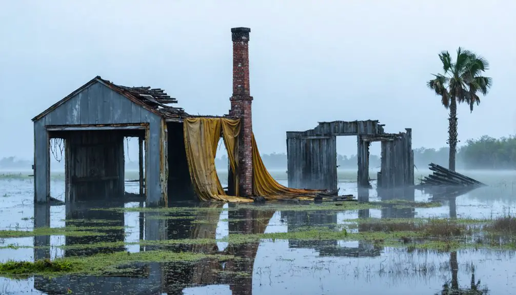
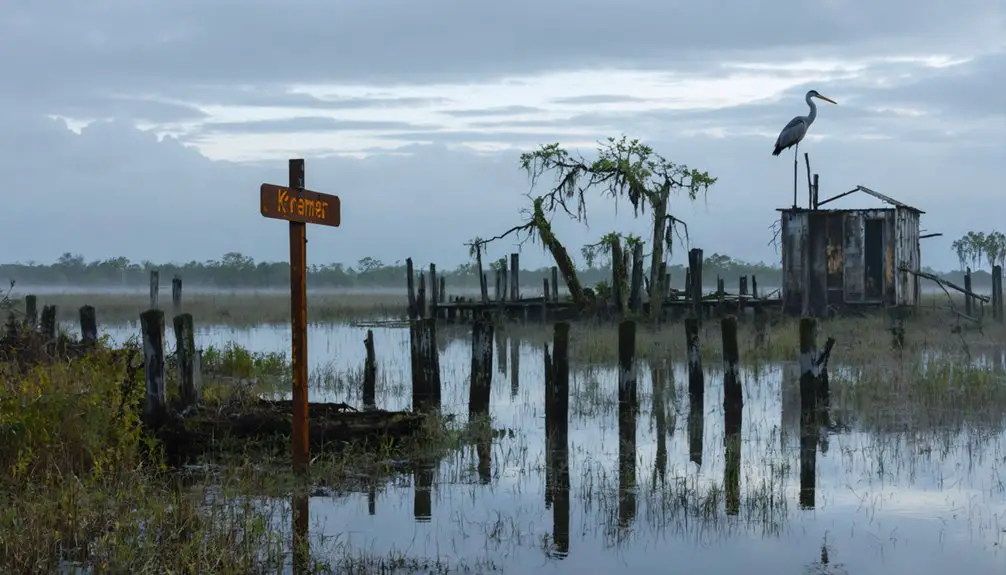
Modern Day Remnants and Legacy
Today, Kreamer Island stands as a tribute to Florida’s pioneer past, accessible only by airboat during wet seasons or recreational vehicles in drier periods.
You’ll find scattered pilings and foundations among the scrub vegetation, silent witnesses to a once-thriving community that included homes, a church, and a multi-purpose building that served as a store and post office.
The island’s cultural heritage lives on through archaeological discoveries made during a 2007 dig, when drought conditions revealed artifacts from 19th and early 20th-century settlers.
While the ghost town’s physical remnants are slowly being reclaimed by nature, satellite imagery still shows traces of old roadways.
The raised Lake Okeechobee dike, flooding, and devastating hurricanes may have forced residents to abandon their homes, but Kreamer Island’s story endures through ongoing research and preservation efforts.
Frequently Asked Questions
What Was the Total Population of Kreamer Island at Its Peak?
You’ll find that Kreamer Island’s peak demographics aren’t precisely documented in historical records, but based on Kreamer Island history and archaeological evidence, the population likely reached several hundred residents at most.
Are There Any Known Living Descendants of Original Kreamer Island Settlers?
Like searching for a needle in a haystack, you won’t find confirmed living descendants today. Despite extensive descendant research, hurricanes and flooding destroyed crucial family history records and community connections.
What Native American Tribes Inhabited Kreamer Island Before European Settlement?
You’ll find the Mayaimi tribe was the primary inhabitant, sharing the region’s tribal history with the Guacata people. Both groups left cultural significance through earthworks and settlements before Seminoles later occupied the area.
How Did Kreamer Island Get Its Name?
After 50+ years of engineering work in Florida, you’ll find Kreamer Island’s history traces to Colonel James N. Kreamer, Disston’s chief engineer who led major drainage efforts in the 1880s Everglades region.
Were There Any Schools or Churches Established on Kreamer Island?
You’ll find that both education facilities and religious institutions existed on the island, including a local school serving farm families and a church that anchored the community until flooding forced abandonment.
References
- https://en.wikipedia.org/wiki/Kreamer_Island
- http://www.gribblenation.org/2018/08/ghost-town-tuesday-ghost-towns-of-lake.html
- https://kids.kiddle.co/Kreamer_Island
- https://education.pbchistory.org/pbc_community/three-islands/
- https://www.ghosttowns.com/states/fl/kreamerisland.html
- https://en.wikipedia.org/wiki/Lake_Okeechobee
- https://www.journaloffloridastudies.org/0102ghosttowns.html
- https://en.wikipedia.org/wiki/List_of_ghost_towns_in_Florida
- https://ohioghosttowns.org/county-data-charts/
- https://ocedcorp.com/regional-data/transportation/