Lake Mead’s receding waters have exposed St. Thomas, a Mormon farming town founded in 1865 that was deliberately flooded during Hoover Dam’s construction in the 1930s. You’ll find concrete foundations, street grids, and remnants of the 14-room Gentry Hotel emerging when water levels drop below 1,070 feet—a phenomenon that’s occurred repeatedly since 2000 due to megadrought. The site also reveals Pueblo Grande de Nevada, an ancient settlement predating St. Thomas by centuries. If you explore further, you’ll discover how 600 residents received minimal compensation before abandoning their homes in 1938.
Key Takeaways
- St. Thomas, founded in 1865, was submerged by Lake Mead in 1938 after Hoover Dam construction flooded the Muddy River Valley.
- The town housed up to 2,000 residents with farms, hotels, stores, and a schoolhouse before evacuation between 1935-1938.
- Drought since 2000 dropped water levels 150 feet, exposing foundations, streets, and ruins at coordinates 36°27′57″N 114°22′13″W.
- Ancient Pueblo Grande de Nevada sites also emerged, revealing Native American structures predating St. Thomas by centuries.
- Accessible via 2.5-mile trail when lake drops 50-70 feet, the site preserves concrete foundations within Lake Mead Recreation Area.
The Mormon Settlement of St. Thomas in Muddy River Valley
When Brigham Young ordered the colonization of the Muddy River Valley in 1864, he set in motion the establishment of what would become one of Nevada’s most significant—and ultimately doomed—agricultural settlements.
By January 1865, Thomas S. Smith and eleven other pioneers laid out St. Thomas near the Virgin and Muddy Rivers’ confluence, dividing 600 acres into five-acre lots.
You’ll find the settlers recognized the valley’s potential, where ancient artifacts revealed previous Paiute, Ancestral Puebloan, and Basket-Maker habitation. Despite expropriating indigenous lands, the Mormon colonists developed sophisticated water management systems, channeling the Muddy River through town via irrigation ditches and filtering drinking water through charcoal-and-sand cisterns. The settlement grew rapidly, with 600 residents establishing homes along streets lined with cottonwood trees. Six months later, settlers established St. Joseph as a second community in the valley.
How Hoover Dam Construction Changed Everything
When Congress authorized Hoover Dam construction in 1928, the federal government began systematically buying out St. Thomas residents whose properties would soon lie beneath Lake Mead’s future waters.
You’ll find that as the dam neared completion in 1935 and Lake Mead began filling, the town’s remaining inhabitants watched the reservoir’s rising waters gradually consume their homes, businesses, and farmlands.
The massive reservoir would eventually hold 15.85 million acre-feet of water at active capacity, permanently transforming the landscape and regional water management throughout the Southwest.
The dam’s construction involved intense labor conditions, with workers enduring extreme heat and dangerous tunnel environments to complete this monumental engineering project.
Federal Authorization and Buyouts
After decades of interstate disputes over Colorado River water rights, the signing of the Colorado River Compact in 1922 marked the breakthrough that would reshape the American Southwest.
You’ll find that legal disputes had blocked dam construction since 1918, until Congress passed the Boulder Canyon Project Act in 1928, authorizing federal funding and Bureau of Reclamation oversight.
The government’s authority extended to property acquisition through eminent domain.
St. Thomas, Nevada’s 200 residents received an average $325 per lot plus relocation assistance during the early 1930s.
By 1939, Lake Mead had submerged the town completely.
Nearby farming communities dependent on the Colorado River faced similar buyouts, with compensation based on appraised values.
The construction was completed ahead of schedule in 1935, demonstrating remarkable efficiency for such a massive public works project.
The dam’s hydroelectric generators became operational by 1937, providing power that would eventually help recover the project’s costs.
You can see these ghost towns today, as drought conditions have exposed their ruins.
Lake Mead’s Rising Waters
As Hoover Dam’s concrete cured in 1935, the Colorado River began its transformation from a free-flowing waterway into the massive Lake Mead reservoir. You’re witnessing one of America’s boldest water control experiments—impounding nearly 29 million acre-feet behind a single structure.
The rising waters rapidly submerged valleys, farmlands, and settlements that once thrived along the riverbanks. By the 1940s, the reservoir reached full capacity, erasing former shorelines under hundreds of feet of water.
Water level fluctuations became the new reality, driven by climatic changes and allocation demands. Sediment accumulation started immediately, with 60-90 feet of silt settling at the lake’s western end.
The dam fundamentally altered the river’s character, slowing its flow and trapping the sediment that once carved the Grand Canyon. This largest U.S. reservoir would eventually span 247 square miles when full, providing water for 25 million people across the Southwest. Straddling the border between Nevada and Arizona, the dam’s reservoir became a critical water source supplying multiple states and even reaching into Mexico.
Town’s Final Submersion
The Colorado River Compact of November 24, 1922, set in motion the legal framework that would seal St. Thomas’s fate. When President Hoover’s proclamation made the compact effective on June 25, 1929, federal appropriations flowed into dam construction by 1930.
You’ll find that Six Companies’ 1931 contract initiated the physical transformation—a 221-meter concrete arch-gravity structure that created America’s largest reservoir by volume.
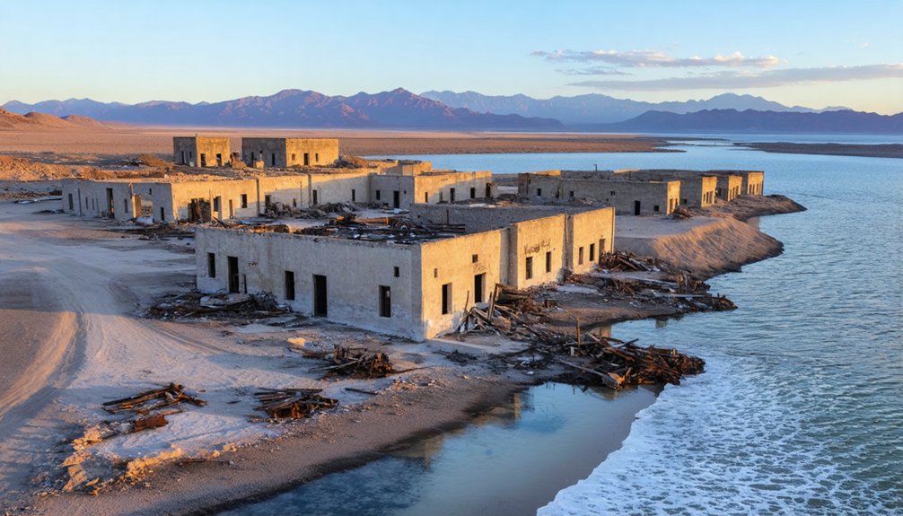
St. Thomas disappeared beneath Lake Mead’s rising waters during construction, its urban decay accelerating as residents abandoned their homes. The architectural remnants you’d recognize today—foundations, walls, and street layouts—spent decades submerged before drought conditions periodically exposed them.
This controlled flooding eliminated the unpredictable disasters that previously plagued downstream communities, trading one town’s existence for regional water security. The dam’s location in Black Canyon provided superior foundation conditions and accessibility compared to alternative sites. The dam’s 17 turbines now power over 1 million homes while holding enough water to irrigate 2 million acres.
The Final Days Before Submersion in 1938
You’d think seven years’ notice would ease the trauma of losing your home, but many St. Thomas residents refused to believe the Colorado River would actually swallow their town until waters lapped at their doorsteps.
The federal government’s 1931 purchase orders triggered a slow exodus from 1935 to 1938, yet some families stayed until boats became the only escape route.
Hugh Lord, the town’s final holdout, paddled away from his flooding home on June 11, 1938, marking the end of St. Thomas’s 73-year existence.
Residents’ Seven-Year Evacuation Notice
When federal authorities authorized Boulder Dam in the late 1920s, St. Thomas residents learned their town would face inundation for flood management purposes. You’ll find this wasn’t a sudden displacement—the government provided seven years’ notice before Lake Mead’s waters arrived in 1938.
During this extended timeline, federal officials purchased homes, farms, and businesses, reimbursing property owners to facilitate relocation. This gradual approach allowed you to salvage possessions and resettle without immediate eviction.
By 1935, when Lake Mead began filling, initial compensation payments commenced. The process enabled orderly departure from what would become urban decay beneath 60 feet of water.
Salvage crews documented final operations in June 1938 as rising waters reached doorsteps, marking the town’s complete abandonment.
Hugh Lord’s Last Departure
As Lake Mead’s waters crept toward St. Thomas in 1938, Hugh Lord became the town’s final resident to evacuate. You’ll find that Lord’s departure marked the culmination of a seven-year exodus, as the reservoir’s storage capacity reached 24 million acre-feet and extended 110 miles upstream.
The impounding process, which began February 1, 1935, transformed the landscape while raising concerns about water quality in the expanding reservoir. Unlike modern worries about industrial pollution affecting Lake Mead, the 1938 submersion represented a different threat: complete obliteration of community infrastructure.
Lord witnessed the powerplant’s expansion, with Generator N-5 operational by June 26, before abandoning his home to the rising waters that would eventually peak at 1220.45 feet elevation in 1941.
Lake Mead’s Droughts Reveal a Sunken Town
Since 2000, Lake Mead’s water levels have plummeted 150 feet to reach 1,041.63 feet above sea level—the lowest point since 1937 when the reservoir was still filling.
Lake Mead has dropped 150 feet since 2000, reaching its lowest level in over 80 years.
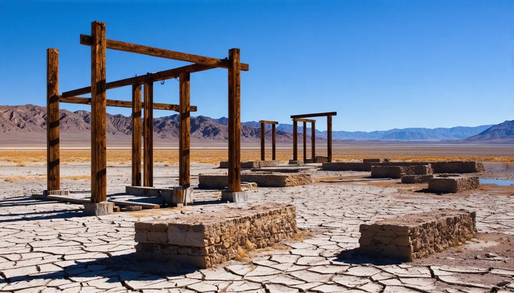
This climate change-worsened megadrought has exposed St. Thomas, a ghost town demolished in the 1930s for the lake’s creation. You’ll find its foundations and road grid visible at the northern Overton Arm, where the Muddy and Virgin Rivers once flowed.
While St. Thomas has reemerged multiple times since 2002, this exposure reveals both cultural preservation opportunities and stark ecological impacts.
The current drought surpasses previous instances in severity, with projections showing continued drying until November’s wet season—if it arrives at all.
The Ancient Lost City Beneath the Waters
Long before St. Thomas disappeared beneath Lake Mead, another settlement vanished from view—Pueblo Grande de Nevada, the Lost City. You’ll find this archaeological complex near Overton housed successive Native American groups including the Anasazi, Pueblo, and Paiutes.
The site featured over 100 rooms, agricultural areas, and prehistoric salt mines.
When archaeologist Mark Raymond Harrington excavated in the mid-1920s, he unearthed walls, tools, weapons, and burial sites. The Civilian Conservation Corps frantically documented findings as Hoover Dam‘s waters rose, recording information until Lake Mead submerged the site in 1938.
Ancient pottery, stone clubs, and sandals now reside in Overton’s Lost City Museum.
Receding waters revealed the ruins again, though erosion damaged them severely. Researchers now study the site using drones and 3-D imaging technology.
What Remains of St. Thomas Today
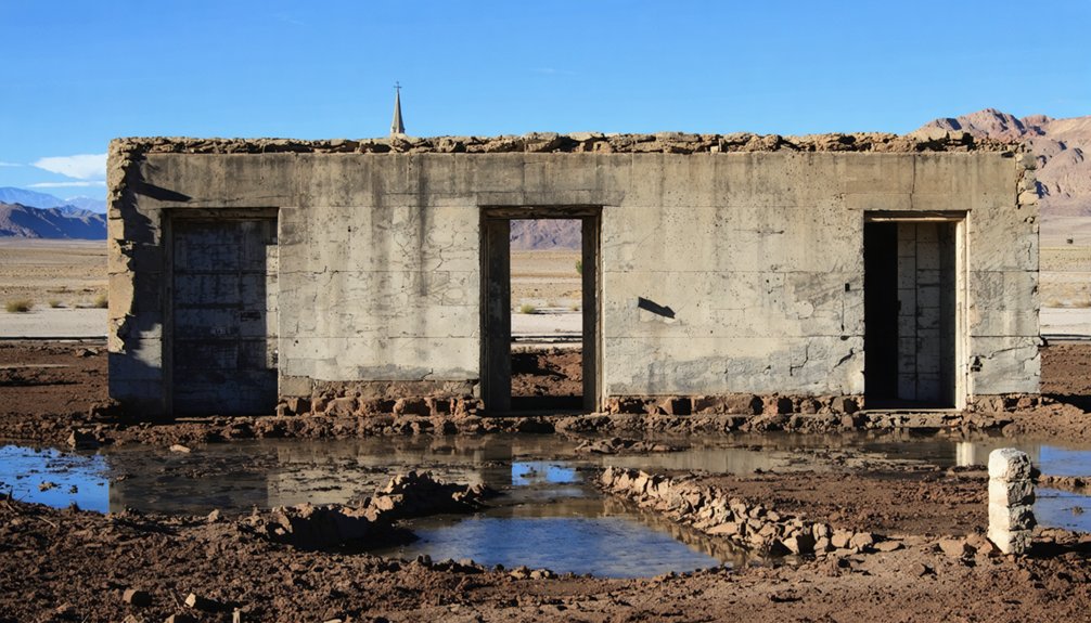
While Pueblo Grande de Nevada remains largely submerged and eroded, St. Thomas offers you tangible evidence of frontier settlement. The National Park Service protects concrete foundations of homes, streets, and the Gentry Hotel as historic preservation sites within Lake Mead National Recreation Area.
You’ll find these archaeological discoveries exposed when drought drops the lake below 50-70 feet of submersion depth. A 2.5-mile loop trail lets you explore independently—no permits required beyond standard park entrance fees.
The remains include tree-lined streets and building foundations, though decades underwater destroyed intact structures. Researchers at Overton’s interpretive center document findings, while vault toilets at Stewart’s Point provide minimal amenities.
You must bring your own water and supplies to this remote site at coordinates 36°27′57″N 114°22′13″W.
Visiting the Ruins at Lake Mead National Recreation Area
Today you’ll find St. Thomas accessible 65 miles northeast of Las Vegas via Interstate 15 and Valley of Fire Highway, with no entry fee required. The ruins lie at Lake Mead National Recreation Area‘s edge, where fluctuating reservoir ecosystems determine visibility.
You can follow a dirt trail from the parking area to explore exposed foundations of the school, post office, grocery stores, church, ice cream parlor, and garages. Download the field guide from nps.gov/lake before visiting.
The National Park Service protects this site, where maritime archaeology continues revealing artifacts as drought conditions lower water levels.
You’ll find hiking trails and geologic formations within 0.4 miles, plus the Lost City Museum 1.4 miles away at Overton’s interpretive center.
Life in Early 20th Century St. Thomas
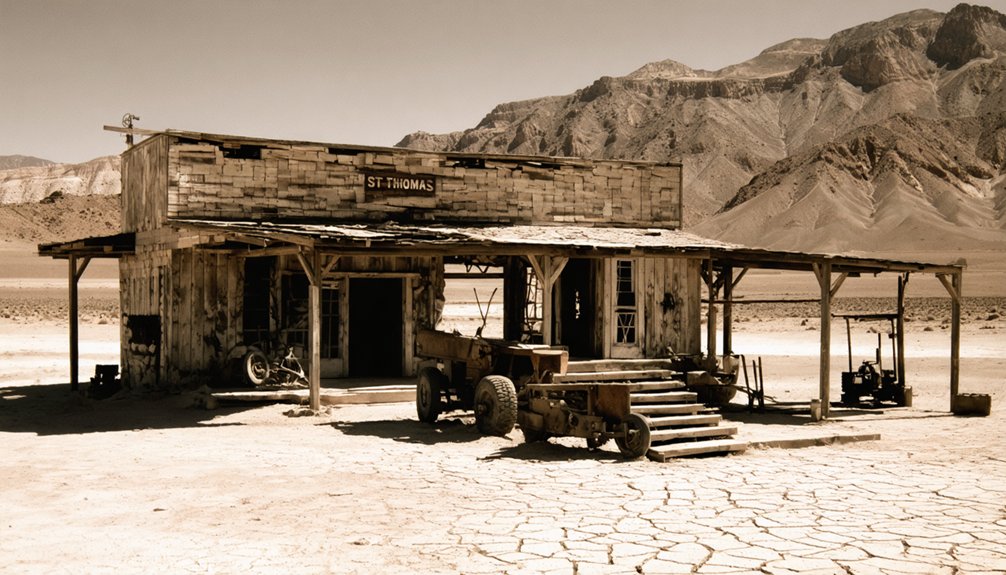
Mormon pioneers led by Thomas Smith established St. Thomas in 1865, creating a tight-knit agricultural community that would peak at 500 to 2,000 residents. You’d have found diverse crops thriving in fertile soil—peaches, melons, wheat, and almonds—shipped via the 1912 railroad spur.
The town featured a 14-room hotel, stores, and a two-story brick schoolhouse serving as church and community center, yet lacked electricity and indoor plumbing. Residents endured brutal summers by sleeping outdoors and cooling in irrigation ditches.
Modern tourism now allows you to explore these ruins when Lake Mead’s waters recede, revealing environmental impact from decades of drought. The 1928 Boulder Dam authorization sealed St. Thomas’s fate, with the last resident departing in 1938 as waters consumed this once-thriving settlement.
Descendant Gatherings and Cultural Legacy
Since the town’s inundation in 1938, descendants of St. Thomas have transformed the ghost town into a gathering place that preserves family traditions and enables genealogical research. You’ll find these reunions occurred strategically during low water levels in 1945, 1965, and 2012, when the town site became accessible.
Nearby, the remnants of abandoned mining towns near Salt Lake City offer a glimpse into the region’s rich history. These sites, often overlooked, provide insight into the lives of those who sought fortune in the harsh landscapes. Exploring these towns can evoke a strong sense of nostalgia and curiosity about the past.
The 1965 gathering particularly featured former Nevada Sen. Berkeley Bunker wearing a hat he’d buried decades earlier.
Families connected to Daniel Bonelli’s early ferry service still inhabit the region, maintaining links to the area’s pioneer heritage.
While the cemetery was relocated to Overton, the exposed foundations and structures serve as tangible connections for descendants conducting genealogical research.
These gatherings reinforce community bonds among displaced families, ensuring the Mormon settlement’s legacy endures beyond the fluctuating waters.
Frequently Asked Questions
Are There Other Submerged Towns in Lake Mead Besides St. Thomas?
Ever wonder what else lies beneath Lake Mead’s surface? You’ll find Calville among the submerged settlements alongside St. Thomas. Historical preservation efforts by the National Park Service protect these flooded communities and ancient Anasazi sites from modern disturbance.
Can Visitors Swim or Dive at the St. Thomas Ruins Site?
You’re not explicitly prohibited from swimming near St. Thomas ruins, but safety concerns like submerged hazards and conservation efforts to protect artifacts strongly discourage it. Park rangers urge visitors to respect the site without climbing or disturbing remnants.
What Wildlife Inhabits the Exposed St. Thomas Ruins Area Today?
You’ll encounter local wildlife thriving ironically where humans failed—desert tortoises, bighorn sheep, rattlesnakes, and numerous bird species now reclaim St. Thomas. Habitat preservation efforts protect these resilient creatures among the crumbling ruins of civilization’s retreat.
How Do Water Levels Affect Visibility of the Ruins Throughout the Year?
You’ll see water fluctuation directly controls visibility variability—St. Thomas emerges above 1,165 feet elevation but disappears below 1,080 feet. Seasonal snowmelt and drought cycles determine whether you can access the ruins throughout any given year.
Were Any Artifacts Recovered From St. Thomas Before It Was Submerged?
By 1938, residents had dismantled and relocated entire houses before flooding began. You’ll find fascinating artifacts weren’t systematically recovered then—archaeological discoveries only happened after 2002 when receding waters exposed St. Thomas’s foundations again.
References
- https://www.roadtripryan.com/go/t/nevada/southern-nevada/st–thomas-ghost-town
- https://vegasghosts.com/the-spirits-of-lake-mead/
- https://www.youtube.com/watch?v=JnIIQymTY3w
- https://www.wef.org/publications/news/wef-news/ghost-town-emerges-from-the-depths-of-lake-mead/
- https://en.wikipedia.org/wiki/St._Thomas
- https://www.npca.org/myparkstory/story/e75c9f53-b26c-4204-8788-32bd22adabd8
- https://www.nvexpeditions.com/clark/stthomas.php
- http://www.onv-dev.duffion.com/articles/muddy-mission
- https://ensignpeakfoundation.org/st-thomas-nevada/
- https://www.nps.gov/lake/learn/nature/st-thomas-nevada.htm


