You’ll discover Lexington and Alma beneath California’s Lexington Reservoir, where these Santa Cruz Mountains settlements thrived from the 1840s through 1940 as crucial stagecoach stops and logging hubs. When drought-driven construction created the reservoir in 1952, both towns vanished underwater. During low water periods, you can spot exposed foundations of hotels, saloons, the original Highway 17 roadbed, and railroad remnants at approximately 550 feet elevation. The area’s history includes frontier violence, devastating mining accidents, and legends of lost treasure that shaped these communities.
Key Takeaways
- Lexington and Alma were 19th-century stagecoach and logging towns in California’s Santa Cruz Mountains along Los Gatos Creek.
- Both towns declined after 1940 when storm damage ended rail service, reducing their economic importance and leading to abandonment.
- Lexington Reservoir construction began in 1952, ultimately submerging both towns beneath 6.5 billion gallons of water by the dam’s completion.
- Low water levels periodically expose submerged ruins including building foundations, original Highway 17 roadbed, and bridge remnants from both towns.
- The towns’ history included frontier violence, industrial accidents, and served as vital stops connecting Los Gatos to Santa Cruz routes.
Early Settlement and Transportation Hub (1847-1940)
When Isaac Branham and Julian Jank constructed their sawmill along Los Gatos Creek in 1848, they established what would become an essential link between Santa Cruz Mountains timber operations and California’s expanding settlements.
You’ll find the town changed hands when Zachariah “Buffalo” Jones purchased the mill for $3,000, naming it Jones Mill before John P. Hennings renamed it in 1860.
The transportation history evolved dramatically as stagecoaches connected Los Gatos to Santa Cruz, making both Lexington and Alma crucial stopping points.
Local architecture included hotels, saloons, and general stores serving loggers and travelers.
When the narrow gauge railroad bypassed Lexington in 1880, Alma emerged as the primary rail hub.
The trains carried timber from Santa Cruz Mountains operations to processing centers throughout the region.
Meanwhile, a different Lexington emerged near Piru and Lockwood Creeks in 1886 following Colonel Smith’s silver discovery, though this mining camp vanished by 1887.
Winter storm damage ended train service in March 1940, sealing both settlements’ fate.
The Building of Lexington Reservoir and Town Submersion
The Santa Clara Valley Water District confronted a growing crisis in 1943 when well water levels dropped throughout the valley, straining the region’s capacity to support its expanding orchard operations. You’ll find that pre-dam agriculture had depleted groundwater resources, prompting officials to propose a new dam on Los Gatos Creek near Windy Point spur.
They’d recharge aquifers through controlled water percolation.
Construction began in spring 1952 after relocating State Route 17. The 195-foot earthen structure rose quickly, creating a reservoir that would hold 6.5 billion gallons. The dam was later renamed James J. Lenihan Dam in 1977 to honor a long-serving director of the water district. The dam creation led to the submersion of Lexington and Alma, two small towns that had served as waypoints during the stagecoach era.
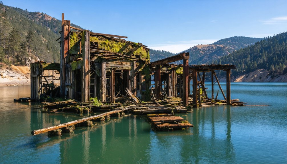
What Lies Beneath: Ruins Exposed During Low Water Events
When water levels drop in Lexington Reservoir, you’ll witness the foundations of hotels, saloons, and stores that once lined the streets of both Lexington and Alma.
The remnants include sections of the original Highway 17 roadbed, which once served as the primary coastal route through Santa Clara Valley before the modern freeway was built overhead.
These exposures typically occur during drought conditions or scheduled dam maintenance, transforming the reservoir floor into an accessible archaeological landscape.
Here, you can trace the physical layout of these nineteenth-century settlements. Visible features include concrete slabs that likely served as garage floors, alongside the base of what appears to be an old sign or lamppost. The town of Alma itself was named after the Alma dance hall, which became a prominent landmark in this Santa Clara Valley community before the reservoir’s creation.
Foundations and Structural Remains
Beneath Lexington Reservoir’s placid surface lie the skeletal remains of two 19th-century communities, revealed only when maintenance needs force dramatic water drawdowns. Foundation archaeology becomes accessible during these rare exposures, particularly evident during the 2008 James J. Lenihan dam repairs and mid-1980s outlet pipe construction.
You’ll spot concrete bases from hotels, saloons, and lumber mills protruding through mud—tangible evidence of Lexington’s turn-of-century decline and Alma’s persistence until the 1950s dam construction. The most intact remnant, a 1920s bridge foundation from Alma, emerges intermittently during spring through early fall low-water periods.
These structural excavations offer fleeting glimpses into communities that served loggers and vacationers as rail stops, now preserved underwater, awaiting the next maintenance event to resurrect their history.
Original Highway 17 Roadbed
Among these submerged foundations, you’ll find the most continuous archaeological feature: the original State Route 17 roadbed, which threaded through both Lexington and Alma before reservoir construction forced its 1952 abandonment. This sunken thoroughfare once connected Los Gatos Creek stagecoach routes to Santa Cruz, lying at 550-551 feet elevation beneath reservoir waters.
Water level management determines when you’ll witness these ghost roads. Drought-driven drawdowns expose:
- Original pavement sections distinguishable from building foundations
- Black Creek bridge remnants crossing the former alignment
- Alma’s road network, more visible than Lexington’s scattered traces
Reservoir engineering submerged this essential corridor permanently, yet seasonal fluctuations grant occasional access. The first stop on the railway line was Alma, now completely underwater except for remnants visible only during extreme low water events. The name “Lexington” itself refers to multiple places, requiring disambiguation when researching historical records and archival materials about this specific California ghost town. Spring through early fall offers peak viewing conditions when receding waters reveal pathways supporting logging operations, vacationer traffic, and commerce until Highway 17’s 1940 rerouting sealed these communities’ fate.
Dark Chapter: Murders, Explosions, and Mining Tragedies
The area’s violent past extends beyond natural disasters to human tragedy and criminal activity. Gold disputes in 1850s Lexington resulted in infamous murders that ended with public hangings, drawing crowds to witness frontier justice.
The 1890s railroad expansion brought its own horrors when a tunnel explosion killed 31 Chinese workers, marking one of the region’s deadliest industrial accidents. Stagecoach and railroad routes were plagued by frequent robberies throughout the era, making travel through the mountains a dangerous undertaking. In nearby Patchen, Mountain Charley McKiernan operated a toll road along an Indian trail during the 1850s, connecting these treacherous mountain passages used by settlers and prospectors alike.
Gold Rush Murder Hangings
As gold fever swept through California’s Sierra Nevada foothills, lawlessness flourished in mining camps where vigilante committees dispensed swift, brutal justice without formal trials.
You’ll find that kangaroo courts operated with frightening efficiency—local citizens appointed themselves judges, and sentences were carried out within hours using mining equipment as makeshift gallows.
Traditional timekeeping practices meant nothing when mobs demanded immediate retribution.
The most shocking cases reveal the era’s brutality:
- Josepha Loaiza became California’s only woman hanged for murder on July 5, 1851, executed before nightfall after a same-day trial
- Mexican and Chilean miners suffered at least 160 documented lynchings between 1848-1860 due to white resentment
- Public hangings served as entertainment and warning in communities lacking formal law enforcement
This pattern of impunity allowed perpetrators to conduct extrajudicial killings without consequences.
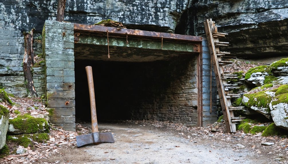
Railroad Tunnel Explosion Deaths
While vigilante mobs terrorized Gold Rush camps above ground, an equally deadly threat lurked beneath the Santa Cruz Mountains three decades later.
During Summit Tunnel’s 1879 construction, methane seepage from the 6,157-foot bore killed over thirty Chinese railroad workers in catastrophic explosions.
The deadliest blast occurred November 17th, when dynamite ignited a gas pocket at 2,700 feet, killing twenty-one Chinese laborers and two white supervisors.
A secondary explosion killed off-shift rescuers that same day.
Workers endured twelve-hour shifts in near-darkness to avoid open flames, with petroleum seeping every ten minutes.
The cultural impacts were profound—Chinese crews believed the tunnel cursed, haunted by victims’ ghosts.
Completion required industrial safety innovations: electric lighting, air pumps, and methane-burning pipes installed through rock fissures.
Famous Visitors and the Railway Era at Wright’s Station
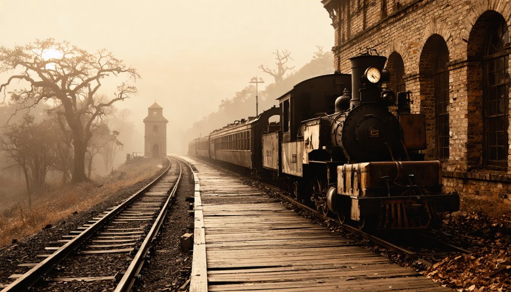
Between 1880 and 1940, Wright’s Station emerged as a premier mountain destination along the South Pacific Coast Railroad‘s narrow gauge line connecting Los Gatos to Santa Cruz. You’ll discover that literary giants Jack London and Mark Twain visited James Richards Wright’s Arbor Villa, a residence-turned-hotel perched at 896 feet elevation near the summit.
Historical artifacts reveal the station’s dual purpose as both tourist haven and agricultural hub.
Southern Pacific directed excursion trains to Sunset Park, where you could explore wildlife habitats while picnickers enjoyed mountain air. The station thrived despite the 1879 tunnel disaster:
- 3,200 acres supplied Almaden Vineyards and Paul Masson with grapes
- Redwood timber flowed from Santa Cruz Mountains to markets
- Six stops connected communities: Alma, Laurel, Glenwood, Clems, Zayante, and Felton
This mountain retreat embodied California’s frontier spirit until Route 17’s 1940 construction ended the era.
Geographic Setting in the Santa Cruz Mountains
Perched at 550 feet elevation in the Santa Cruz Mountains of Santa Clara County, Lexington claimed a strategic position along Los Gatos Creek where mountain terrain met valley access. You’ll find the location nestled in hills characterized by cool, wet winters and warm, dry summers—conditions that shaped both settlement patterns and natural wildlife habitats throughout the region.
As you explore the surrounding area, don’t miss the chance to visit historic sites in Louisiana Grange, where the rich cultural heritage is vividly displayed. These landmarks tell the stories of the past and offer unique insights into the region’s history and development. The combination of natural beauty and historical significance makes this area a captivating destination for visitors and locals alike.
The 1952 reservoir creation dramatically altered the landscape’s environmental impact, submerging not just human structures but entire ecosystems.
Today’s overgrown forests reclaim what was once a bustling transportation corridor connecting the Santa Clara Valley to coastal destinations. When drought conditions lower water levels, you can glimpse original road pavements and foundational structures—ghostly reminders of communities that thrived before modern infrastructure demands forever changed this mountainous terrain.
The Lost Padre Mine Legend and Silver Mining Boom of 1886-1887
Long before Colonel A.W.. Smith announced his December 1886 “rediscovery” near Piru Creek, mining folklore had circulated about Spanish padres operating a secret silver and gold mine during California’s mission period.
Spanish missionaries allegedly concealed a rich mine during California’s mission era, spawning folklore that would persist for generations.
The legend claimed priests concealed their operation during the 1830s secularization, allegedly placing a death curse on anyone revealing its location.
Smith’s claims sparked Lexington’s explosive 1887 boom:
- 150 prospectors flooded the camp by February
- Surveyor J.V. Jesse platted an entire townsite at Lockwood Flat
- Five mining claims promised “the richest discoveries ever made”
Legend skepticism emerged quickly that spring as promised strikes never materialized.
Despite newspaper comparisons to the Comstock Lode fading entirely, respected citizens like Samuel Bishop spent decades searching, suggesting the Lost Padre Mine maintained its grip on determined fortune-seekers.
Exploring the Ghost Towns Today: What Remains Above Water
Though Lexington’s 1887 boom promised untold riches, today’s visitors to Lockwood Flat in eastern Ventura County will find no standing structures, no marked trails, and no official recognition of the townsite that once drew 150 fortune-seekers.
Unlike regional ghost towns lost to reservoir construction, Lexington wasn’t submerged—there are no underwater artifacts or submerged structures to explore. The terrain remains above water at elevation, west of I-5 near Frazier Park.
You’ll encounter only flat ground where buildings once stood, with cottonwoods marking former mine entrances. Metal detectorists have reportedly discovered silver ingots near hollow trees, though verification remains elusive.
Access requires traversing Ventura County backroads across likely private land. No preservation efforts, commercial tours, or signage exist to guide independent exploration of Section 15’s abandoned mining camp.
Frequently Asked Questions
Can You Swim or Boat in Lexington Reservoir Today?
You can’t swim in Lexington Reservoir due to safety regulations and historical preservation concerns, but you’re free to boat from the public launch facility. Check recreational activities status for harmful algal blooms before visiting today.
Are There Any Preservation Efforts for the Submerged Town Artifacts?
You can’t preserve what’s sleeping with the fishes—no underwater archaeology or preservation initiatives protect the submerged artifacts. However, nearby Alma College buildings you’ll find preserved on dry land through open space district efforts, giving you accessible historical connections.
Is It Legal to Dive Down to Explore the Underwater Ruins?
Legal restrictions aren’t explicitly documented, but diving safety concerns and Santa Clara Valley Water District management suggest you’d need permission. Contact the district directly to verify current regulations before exploring these submerged historical sites underwater.
How Often Does the Water Level Drop Enough to See Remnants?
You’ll see remnants only during exceptional droughts or dam maintenance—there’s no predictable schedule. Water level fluctuations depend on precipitation and reservoir management, not regular patterns. Historic preservation occurs naturally underwater, protecting these community remnants from unauthorized exploration.
Were Residents Compensated When Their Homes Were Submerged in 1952?
The historical record remains silent as snow—residents’ compensation details haven’t surfaced in available archives. You’ll find historical land rights documentation from 1952 scarce, leaving affected families’ stories frustratingly incomplete. Community memories suggest minimal restitution occurred before submersion.
References
- https://www.planetizen.com/node/36453
- https://www.clairitage.com/2020/02/14/lexington-the-long-lost-treasure-of-a-long-lost-town/
- https://santacruzlife.com/santa-cruz-ghost-towns/
- https://www.youtube.com/watch?v=YrrzW-szYXk
- http://rhorii.com/Lexington/Lex.html
- https://www.ghosttowns.com/states/ca/lexingtonandalma.html
- https://en.wikipedia.org/wiki/Lexington
- https://en.wikipedia.org/wiki/Alma
- https://kids.kiddle.co/Lexington_Reservoir
- https://www.hmdb.org/m.asp?m=55147


