You’ll find Little Rock ghost town nestled along the Illinois River in LaSalle County, about 90 miles southwest of Chicago. This 19th-century settlement thrived through strategic river access, Norwegian immigration, and the Illinois & Michigan Canal’s 1848 opening. The town’s decline came from shifting transportation routes and economic isolation when railroads bypassed it for larger settlements. Today, the LaSalle County Historical Society preserves Little Rock’s rich cultural legacy through exhibits and archives that reveal fascinating details of this lost settlement.
Key Takeaways
- Little Rock was a 19th-century settlement in LaSalle County, Illinois, located 90 miles southwest of Chicago near the Illinois River.
- The town’s economy initially thrived through river trade, canal access, and agricultural activities before facing economic decline.
- Bypassing of railroad routes in favor of larger settlements contributed significantly to Little Rock’s isolation and eventual abandonment.
- Environmental challenges and resource depletion, combined with disrupted trade routes, accelerated the town’s decline into ghost town status.
- The LaSalle County Historical Society preserves Little Rock’s legacy through exhibits, records, and cultural heritage documentation efforts.
Geographic Location and Natural Features
Located in LaSalle County, Illinois, Little Rock’s historical site lies at coordinates 41.3180901 N, -89.0467486 W, approximately 90 miles southwest of Chicago.
The region’s precise location can be mapped using the UTM coordinates 16T 325305.10749605 4578382.0275517.
You’ll find the site nestled within the Illinois River Valley, where geological features include sedimentary rock formations and glacial deposits characteristic of the Midwest’s terrain.
The town’s location near La Salle, Illinois provided important connections to regional trade and transportation networks during its early development.
The area’s river ecosystems are shaped by the Little Vermillion and Illinois Rivers, creating diverse floodplains that support local wildlife and vegetation.
You’re surrounded by a mix of forests and grasslands, with fertile soil supporting agricultural activities throughout the region.
The temperate climate delivers cold winters and warm summers, while nearby Starved Rock State Park offers opportunities to explore the area’s natural heritage.
The landscape’s unique composition reflects thousands of years of geological and environmental development.
Early Settlement History
Before European pioneers arrived, you’d have found Native American settlements from the Illinois Confederacy dotting the landscape around Little Rock, with the Kaskaskia village serving as a prominent settlement across the river.
The area held strategic importance as French explorers Jolliet and Marquette first documented the region in 1673. When permanent American settlement began in the late 1820s, you could observe the gradual displacement of Native populations as New England families established farms and trading posts in the area.
While Norwegian immigrants would later contribute greatly to the region’s development, the initial settlement period was dominated by American pioneers like Burton Ayres, who established one of the first farms and blacksmith shops in 1830. Nearby Norway township was established by settlers like Andrew Osmundsen who came directly from their Norwegian homeland.
Original Native American Presence
Native American tribes established deep roots in what would become LaSalle County long before European settlement, with archaeological evidence revealing continuous indigenous occupation spanning over 10,000 years.
The Native presence included the Illinois Confederation, whose Kaskaskia tribe maintained a significant village at Starved Rock, and later the Three Fires Confederacy of Potawatomi, Chippewa, and Ottawa peoples who migrated from Michigan around 1745.
You’ll find the cultural significance of these tribes reflected in the archaeological remnants throughout the region, including burial mounds at Dayton Bluffs dating back 1,000-1,500 years.
These early inhabitants practiced sophisticated agricultural techniques like the “Three Sisters” method and developed advanced hunting practices, evolving from spears to bow and arrow technology while establishing seasonal migration patterns along the Illinois River valley.
Archaeological excavations in the late 1940s revealed Native American graves containing glass beads and brass Jesuit rings, providing insights into their cultural practices.
Norwegian Migration Impact
While indigenous peoples shaped the early history of LaSalle County, the arrival of Norwegian immigrants in 1834 marked the beginning of a transformative era for the region. Under the leadership of Cleng Peerson, who walked over 2,000 miles to scout the land, Norwegian pioneers established the Fox River Settlement, purchasing fertile farmland at $1.25 per acre.
You’ll find that community networks quickly developed as ships like *Den Norske Klippe* and *Norden* brought 167 more immigrants in 1836. The settlement’s influence grew around Norway, Illinois, which became a cultural hub for Norwegian-Americans. The oldest Norwegian-Lutheran Church in America was constructed here in 1841. This wave of immigration reflected the larger trend of Norwegians seeking new opportunities, as Norway’s population had increased dramatically from 150,000 to 400,000 between 1000 and 1300.
Strong cultural preservation efforts continued through generations, with families maintaining their traditions, language, and heritage. Today, the State of Illinois Norwegian Settlers Memorial stands as a monument to these pioneering immigrants’ legacy.
Indigenous Heritage and French Exploration
For more than 10,000 years prior to European contact, the Illinois Valley flourished as home to diverse indigenous peoples, including the Peoria and Cahokia tribes.
You’ll find evidence of their presence in the numerous earthworks and mounds throughout LaSalle County, where they strategically built settlements along rivers and bluffs.
When French explorer La Salle arrived in 1683, he established Fort St. Louis at Starved Rock, fostering indigenous alliances and French trade networks.
Henri de Tonty constructed the fort’s wooden palisade, chapel, and warehouse.
The tribes sustained themselves through seasonal hunting patterns, moving between summer agricultural villages and winter hunting grounds.
By 1691, many Illinois subtribes relocated to Lake Peoria, though the Peoria tribe maintained their presence until the 1750s.
The strategic location near the Illinois and Michigan Canal would later become crucial for trade between Chicago and St. Louis.
Through subsequent treaties with the U.S. government, these tribes eventually moved to Kansas and Oklahoma, where their descendants, the Consolidated Peoria Tribe, live today.
Norwegian Immigration Impact
The cultural landscape of LaSalle County transformed dramatically in 1834 when Norwegian immigrants established their first settlement along the Fox River.
Led by Cleng Peerson, these pioneers, known as the “Sloopers,” sought religious freedom and agricultural opportunities in the fertile valley. You’ll find that Norwegian traditions flourished as families maintained strong community cohesion through their Hauge Lutheran faith and cultural preservation efforts.
Under Cleng Peerson’s leadership, the Sloopers built a thriving Norwegian community unified by their Hauge Lutheran beliefs and cultural heritage.
The settlers’ agricultural practices reshaped the region’s economy, with established families providing immigration support to newcomers through chain migration.
Their legacy lives on through the Norwegian Settlers Memorial and various commemorative programs. Multiple generations worked together, creating prosperous farming communities that became the foundation of Norwegian-American life in the Fox River Valley, particularly in the town of Norway, Illinois.
Rise and Development Along Illinois River
Situated along the south banks of the Illinois River, Little Rock emerged as a strategic settlement northeast of Oglesby during the early 19th century’s westward expansion.
You’ll find the town’s location was chosen for its natural advantages – steep bluffs provided defense while the river offered crucial transportation access. River navigation shaped settlement dynamics, as Little Rock’s founders capitalized on the waterway’s role in commerce and trade.
The site’s history runs deep, building upon layers of indigenous presence and French colonial activity.
The Illinois tribe and earlier Mound Builders left their mark on the landscape, while French traders established nearby posts.
As Little Rock grew, it joined a network of river settlements that relied on water-based commerce for survival, though it would later struggle against larger towns with better infrastructure.
Economic Activities and Trade Routes
During its early development, Little Rock’s economy thrived on diverse trade networks established by Indigenous peoples and French fur traders along the Illinois River.
Native American trade routes and French fur trading created a vibrant economic hub along the Illinois River at Little Rock.
You’ll find evidence of robust trade dynamics in artifacts from Mound Builder sites, showing extensive regional exchange networks that later merged with French colonial commerce flowing between Montreal and New Orleans.
As trade routes evolved, the Illinois & Michigan Canal‘s opening in 1848 transformed Little Rock’s economic landscape, connecting you to Chicago’s bustling markets.
When railroads arrived in the 1850s, economic shifts accelerated. The area participated in LaSalle County’s booming mineral industry, with silica sand, limestone, and coal extraction becoming essential to the local economy.
You’d have found agricultural trade flourishing too, with wheat and corn surpluses moving through established market networks via canal and rail systems.
Factors Leading to Abandonment
You’ll find that Little Rock’s position along the Illinois River became less strategic as new transportation routes shifted trade away from the settlement.
The changing patterns of river commerce left Little Rock isolated from major economic corridors, causing merchants and traders to relocate their operations downstream to more prosperous locations.
These economic shifts triggered a mass exodus of the population, with families moving to growing settlements like Cahokia and Kaskaskia where trading opportunities remained viable.
River Trade Decline
As French colonial influence waned in the early 1700s, Little Rock’s once-bustling river trade began a steady decline due to multiple converging factors.
You’d have witnessed the depletion of local resources, with overharvested timber, exhausted farmland, and dwindling game driving settlers southward.
The river trade suffered further as environmental challenges mounted – flooding damaged crucial infrastructure while siltation and shifting channels made navigation treacherous for larger vessels.
The economic shift away from fur trading dealt another blow, as newly established Mississippi River settlements like Cahokia drew commerce downstream.
You’d have seen fewer trading vessels as hostile relations with indigenous tribes disrupted traditional trade routes, while soil erosion and unreliable seasonal water flows made Little Rock’s river port increasingly impractical for year-round commerce.
Transportation Routes Changed
While Little Rock’s decline had begun with diminishing river trade, the transportation revolution of the mid-19th century sealed its fate.
You’d have witnessed a dramatic transportation evolution as railroads bypassed the settlement, with the Illinois Central Railroad favoring larger towns like LaSalle and Oglesby.
The town’s economic isolation intensified when it missed out on both rail and later highway connections.
Population Migration Patterns
The complex interplay of resource depletion, social conflict, and shifting economic priorities drove population movements away from Little Rock during the 18th and 19th centuries.
You’ll find that population dynamics in the area followed a cyclical pattern. Native Americans initially concentrated around the limited timber groves and water sources, but depleted local game and resources.
Later, French settlers established temporary posts that they’d eventually abandon due to conflicts with the Iroquois and Fox tribes. Settlement trends then shifted toward prairie regions as agricultural technology improved, bypassing Little Rock’s limited farmland potential.
The area’s unstable history, marked by burned forts and territorial disputes, discouraged permanent residence. Settlers ultimately favored locations offering better agricultural opportunities and more stable conditions, leaving Little Rock to fade into obscurity.
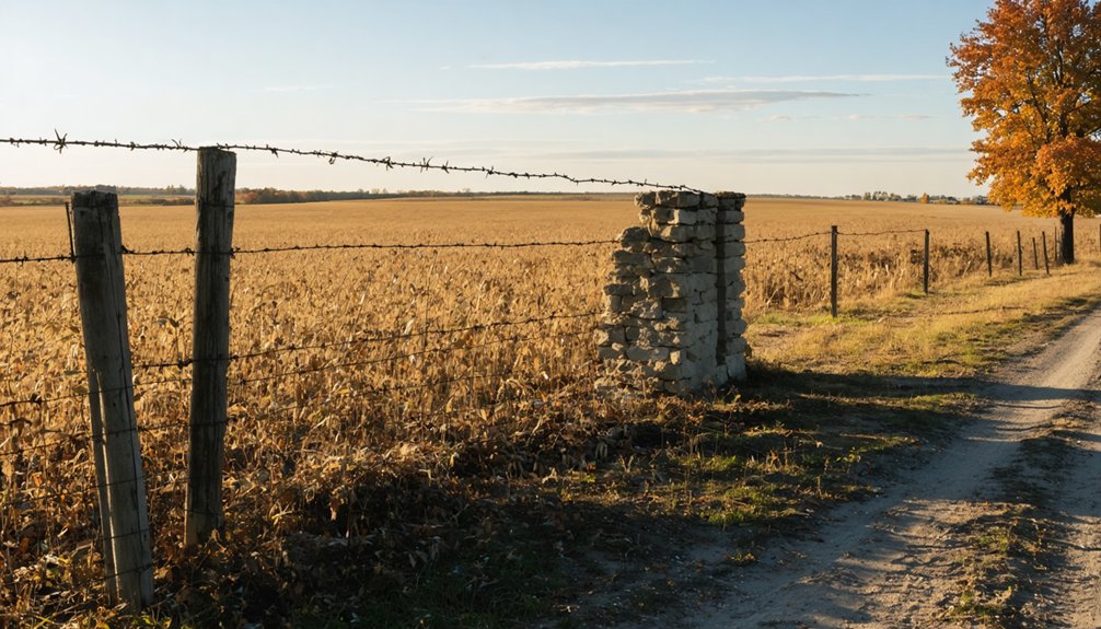
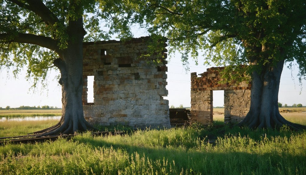
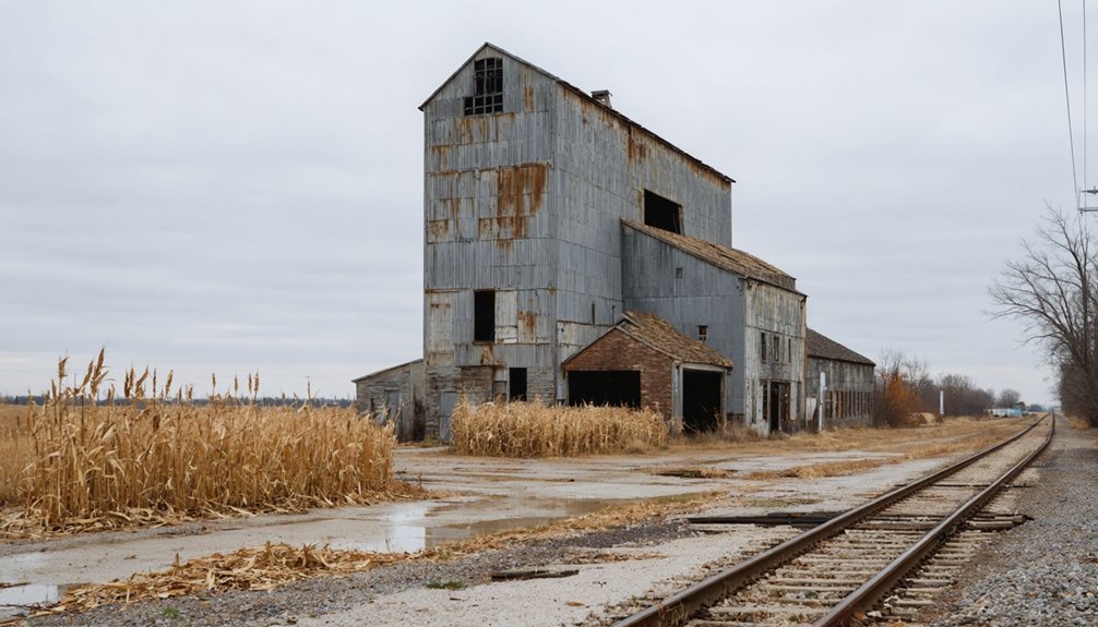
Physical Remnants and Archaeological Evidence
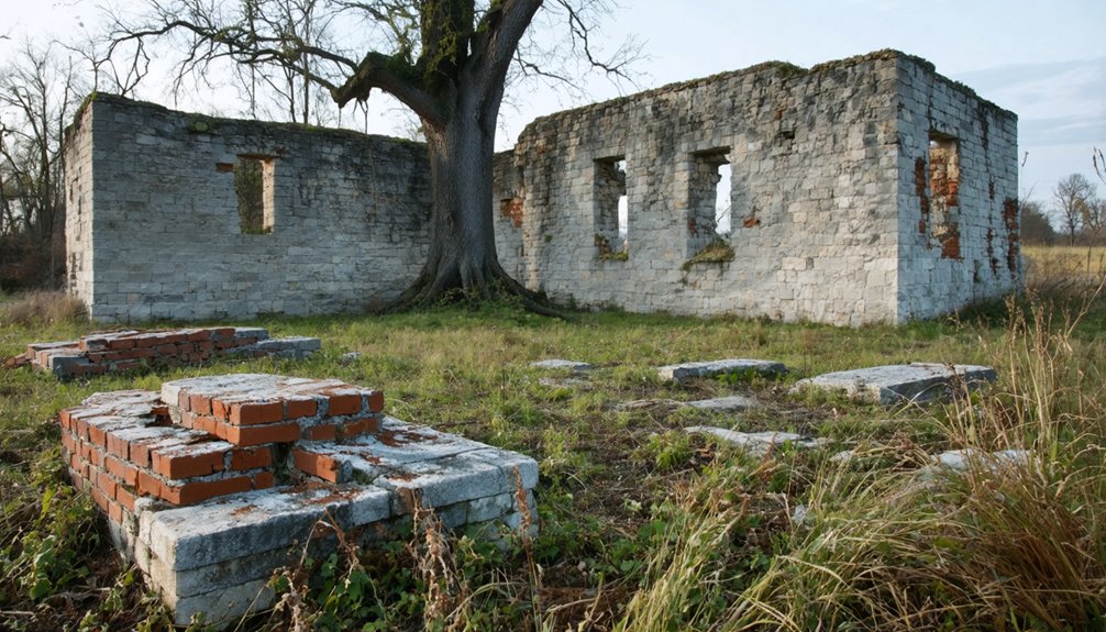
Located on the south banks of the Illinois River in La Salle County, Little Rock’s physical remains have largely vanished from the landscape today.
While no intact buildings survive, the site retains significant archaeological potential beneath the surface. You’ll find the settlement’s footprint among bluffs and river terraces, where erosion has shaped deep channels and exposed sandstone strata.
Though no formal excavations have been documented, you might discover foundations, cellar depressions, or industrial installations hidden in the soil.
The material culture typical of frontier settlements – ceramics, glass bottles, metal tools, and trade goods – likely exists in plow-disturbed areas or erosion zones.
Agricultural development and river flooding may have impacted the site’s stratigraphy, but historical maps and documents can guide future archaeological investigations of this vanished river town.
Cultural Legacy in LaSalle County
Despite its physical disappearance, Little Rock’s cultural influence endures through LaSalle County’s vibrant heritage preservation efforts.
You’ll find its legacy woven into the fabric of cultural festivals like the Burgoo Festival and Wild Bill Hickok Days, where the community comes together to celebrate their pioneer roots.
The LaSalle County Historical Society, established in 1907, keeps these memories alive through interactive exhibits and demonstrations of traditional crafts.
- Experience blacksmithing demonstrations and pioneer trades at the Historical Society campus
- Discover Native American cultural heritage through preserved artifacts and oral histories
- Explore the stories of early settlements through museum exhibits and educational programs
- Connect with community identity through seasonal festivals and heritage celebrations
Your connection to this vanished settlement continues through these preserved traditions and shared cultural memories that shape LaSalle County’s unique historical narrative.
Historical Documentation and Records
Historical records paint a detailed portrait of Little Rock’s existence through maps, plats, and scholarly works from the 19th century.
You’ll find significant documentation in Elmer Baldwin’s 1877 “History of La Salle County, Illinois,” which provides essential context about the settlement’s place within the region’s development.
The settlement’s historical significance is preserved through various archival sources, including local genealogy indexes, township records, and the Digital Research Library of Illinois History Journal.
While you won’t find detailed census or postal records specific to Little Rock, the settlement’s story lives on through contemporary historical documentation efforts.
Local historical societies continue working to maintain Little Rock’s legacy, incorporating digital archives and online platforms to guarantee this ghost town’s history remains accessible to future generations.
Frequently Asked Questions
Were There Any Notable Crimes or Mysterious Deaths in Little Rock?
Like a dusty, empty ledger, you won’t find any documented notable crimes or mysterious deaths in Little Rock, though nearby La Salle County has unsolved mysteries and ghostly sightings in other locations.
What Was the Peak Population of Little Rock During Its Existence?
You won’t find exact records, but based on demographic changes and population growth patterns in LaSalle County, Little Rock’s peak population likely didn’t exceed 500 residents during its active settlement period.
Did Any Famous People or Historical Figures Visit Little Rock?
You won’t find evidence of any famous visitors or historical figures stopping in this settlement. Historical records and local archives don’t document any nationally or regionally significant people visiting Little Rock.
Were There Schools or Churches Established in Little Rock?
You won’t find historical records of established schools or churches in Little Rock. Local archives don’t document any school history or church significance within this small Illinois River settlement.
What Happened to the Residents After They Left Little Rock?
Over 75% of Little Rock’s residents moved to nearby towns like Oglesby, LaSalle, and Peru. You’ll find post evacuation stories showing they took up farming, railroad work, and trade in these growing communities.
References
- https://www.youtube.com/watch?v=2Fl5DSp4qTM
- https://drloihjournal.blogspot.com/2022/09/lost-towns-of-illinois-little-rock.html
- http://genealogytrails.com/ill/lasalle/township_index.html
- https://en.wikipedia.org/wiki/Little_Rock
- https://libsysdigi.library.uiuc.edu/oca/Books2008-06/historyoflasalle00bald/historyoflasalle00bald.pdf
- https://freepages.rootsweb.com/~gtusa/history/usa/il.htm
- http://livinghistoryofillinois.com/pdf_files/Past and present of La Salle County
- https://en.wikipedia.org/wiki/List_of_ghost_towns_in_Illinois
- https://www.latlong.net/place/la-salle-il-usa-32309.html
- https://latitude.to/articles-by-country/us/united-states/29305/lasalle-illinois