You’ll find Low, Utah between the Cedar and Grassy Mountains, where a once-vital Western Pacific Railroad settlement established in 1880 now stands abandoned. The site served as a critical maintenance stop and housed workers during the railroad’s expansion through the Great Basin. Water scarcity and harsh desert conditions eventually forced residents to leave, but you can still spot remnants of water towers, telegraph lines, and crumbling infrastructure that tell a compelling story of western rail development.
Key Takeaways
- Low was established in 1880 as part of Western Pacific Railroad’s expansion, situated between Cedar and Grassy Mountains in Utah.
- The town’s population declined severely due to persistent water scarcity and harsh desert conditions, with temperatures ranging from 90°F to freezing.
- Historical remnants include decaying hotel, schoolhouse, water towers, and telegraph lines from its railroad operation days.
- The site’s final decline occurred in 1942 when tracks were removed during World War II, transforming it into an archaeological site.
- Located at 4,600 feet elevation, Low served as a vital transportation hub with strategic value for the Western Pacific Railroad.
The Birth of a Railroad Camp
While many railroad camps dotted Utah’s landscape during the late 19th century, Low’s establishment in 1880 marked a strategic development in Western Pacific Railroad‘s expansion.
You’ll find its origins rooted in the practical needs of railroad construction, positioned precisely where the terrain offered a natural passage between the Cedar and Grassy Mountains.
The camp emerged as a temporary settlement, purposefully chosen for its location rather than its resources. The site’s below standard elevation made it ideal for rail construction through the challenging terrain.
Mormon laborers and miners provided much of the workforce needed to establish the camp and build the rail lines.
Without a permanent water source, Low’s founders focused solely on building the essential infrastructure needed to support construction crews and maintenance operations.
The site’s development reflected the raw determination of railroad pioneers, who carved out functional spaces in Utah’s remote expanses, prioritizing rail progress over permanent settlement prospects.
Life Along the Western Pacific Line
Three key elements defined life along the Western Pacific Line: engineering feats, operational challenges, and strategic commerce.
You’ll find evidence of railroad culture in the 43 tunnels and numerous trestle bridges that showcased the engineering prowess needed to conquer the terrain. Workers faced brutal conditions, especially at places like Low, Utah, where they struggled with water scarcity in the harsh desert environment. Six hundred men worked tirelessly by late October 1905 to establish grade into the Great Salt Lake Desert.
Laborers endured extreme hardships while building the railway’s complex infrastructure of tunnels and bridges through unforgiving desert landscapes.
This ghost town, once an essential construction and maintenance camp, tells the story of sacrifice and determination. The completion of the Western Pacific Railway from 1906-1909 marked a significant expansion of Utah’s rail network.
The line’s strategic importance grew after 1908 when it connected with Nevada Northern Railway at Shafter, enabling critical copper ore shipments.
Despite initial financial struggles, the railroad’s efficiency – with grades under one percent and routes below the snow line – made it an increasingly significant transportation link.
Water Struggles in the Desert
You’ll find that water scarcity shaped the fate of many desert towns, as evidenced by settlements like Rockport that now emerge from drought-depleted reservoirs.
When you examine Utah’s arid landscape, you’re witnessing a region where persistent drought cycles have forced communities to adapt or disappear, with reservoir levels dropping to historic lows and affecting nearly 2.8 million residents. The Rockport Reservoir has fallen to just 29% capacity, revealing long-submerged foundations and roads. The first white settlers arrived in the area in 1860, establishing what would become a community of 27 families.
Your understanding of desert settlement patterns must account for how water availability dictates population sustainability, as demonstrated by the displacement of Rockport’s 200 residents when federal authorities prioritized water storage over town preservation.
Desert Water Supply Challenges
As the harsh desert environment posed persistent challenges for Low’s inhabitants, managing water resources became a critical survival imperative.
You’d find evidence of their water scarcity struggles in the remaining infrastructure, where they’d implemented conservation strategies similar to those used throughout Utah’s history. The settlement relied heavily on local water sources, much like today’s communities that depend on vulnerable systems like the Virgin River basin. With 77 percent experiencing drought, Utah’s current water challenges echo the historical struggles of settlements like Low.
The town’s water management approach mirrors modern challenges, where you’ll see similar patterns of peak summer demands reaching up to six times winter usage. Despite their best efforts, Low’s residents faced constraints comparable to Iron County’s modern groundwater overdrafting problems, which have led to significant infrastructure damage.
Like contemporary Utah settlements, Low’s residents had to carefully monitor and regulate their precious water supplies, developing systems to store wet-season surplus for use during extended dry periods.
Population Decline From Drought
While Low’s initial population showed promise during its early settlement years, severe drought conditions and unreliable water access triggered a devastating exodus that would ultimately seal the town’s fate.
Like Park City, which saw its population plummet from 7,000 to 1,366 between the mining era and 1960, Low experienced a dramatic decline in residents.
You’ll find this pattern reflected across Utah’s desert communities, where water scarcity forced residents to abandon their homes and livelihoods. Similar challenges faced Silver Reef, located in one of the hottest and driest regions of Utah. As reservoirs dried up and irrigation systems failed, families faced impossible choices about staying or leaving.
The harsh reality of population migration became evident as drought intensified, closing essential services and destroying agricultural prospects.
You can trace similar outcomes in places like Rockport and Grafton, where environmental pressures made sustainable living impossible. When water sources couldn’t support basic needs, businesses shuttered and schools emptied, creating a downward spiral that transformed once-vibrant communities into ghost towns.
Legacy of Transportation
Throughout its brief existence, Low, Utah served as an essential transportation nexus centered on the Western Pacific Railroad operations.
Low, Utah emerged as a vital railroad hub, anchoring Western Pacific’s operations during its short but significant existence.
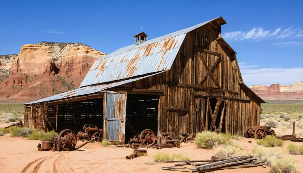
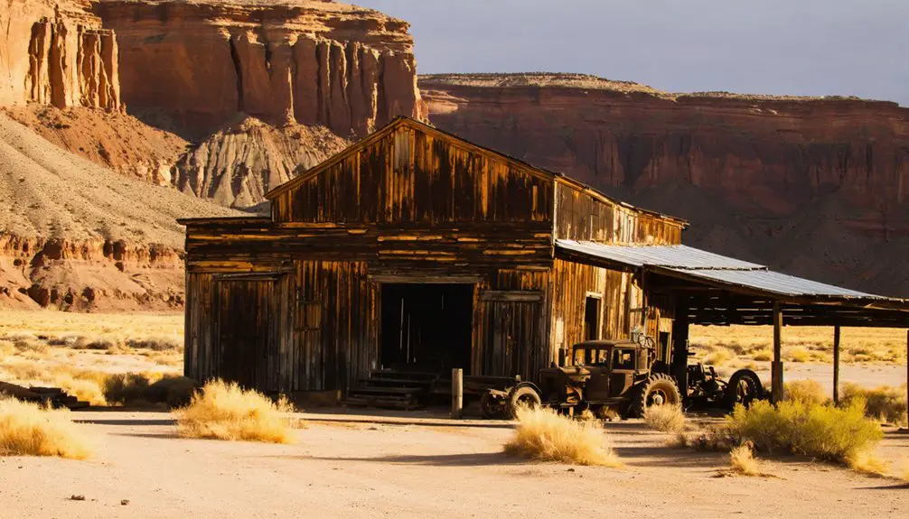
You’ll find evidence of its logistical significance in the remnants of water towers and telegraph lines that once supported steam locomotives crossing northern Tooele County.
The transportation evolution of Low reflects broader changes in American mobility. While initially critical for railroad maintenance, the site later expanded to include the Low Flight Strip military airfield.
Today, Interstate 80‘s Low Interchange marks this historic location, and proposed plans for a nuclear fuel shipping corridor demonstrate the area’s enduring strategic value.
Despite the town’s abandonment in 1955, Low’s legacy lives on through these evolving transportation networks, showcasing how essential infrastructure nodes can persist even after their original purposes fade.
Geographic Features and Natural Setting
Low’s mountain pass location between the Cedar Mountains and Grassy Mountains provided a natural corridor that made it an attractive settlement point at 4,600 feet elevation.
You’ll find the town’s harsh desert environment typified the challenges faced by many Great Basin settlements, with limited water resources and extreme temperature variations.
The arid climate and lack of reliable water sources ultimately proved insurmountable for permanent settlement, leading to the town’s abandonment in 1955.
Mountain Pass Location
Situated at approximately 40.78585° N latitude and 4,600 feet above sea level, the ghost town of Low occupies a strategic mountain pass between Utah’s Cedar Mountains to the south and Grassy Mountains to the north.
The pass’s geographic significance stems from its natural gap formation, which provided an ideal route through the rugged terrain of northern Tooele County.
You’ll find this mountain pass accessibility played a vital role in transportation development, particularly for the Western Pacific Railroad’s placement.
The surrounding landscape features a mix of volcanic and sedimentary rocks, with the pass serving as a changeover zone between mountainous terrain and the desert basin environment.
While water scarcity ultimately limited permanent settlement, the pass continues to influence modern transportation planning, including the nearby Interstate 80 and proposed rail infrastructure projects.
Desert Climate Challenges
While seemingly inhospitable, the desert climate surrounding Low presents a stark portrait of environmental extremes that shaped the town’s ultimate fate.
You’ll find temperatures swinging dramatically between scorching 90°F summers and freezing winters, making desert survival particularly challenging. The area receives less than 10 inches of annual rainfall, with high evaporation rates that quickly claim what little moisture exists.
The harsh conditions have left their mark on the landscape, where only the hardiest plants like sagebrush and juniper demonstrate successful climate adaptation.
Without reliable water sources – no springs, streams, or easily accessible groundwater – sustaining life proved formidable. The sandy, rocky soils retain little moisture, and occasional dust storms sweep through the region, further testing any attempts at permanent settlement.
Tales From the Abandoned Rails
Standing amid the crumbling remnants of Low’s rail infrastructure, you can almost hear the phantom whistles of trains that once thundered through this Utah settlement.
Railroad folklore echoes through the weathered wooden buildings and toppling structures, telling stories of a bustling community that lived and died by the rails.
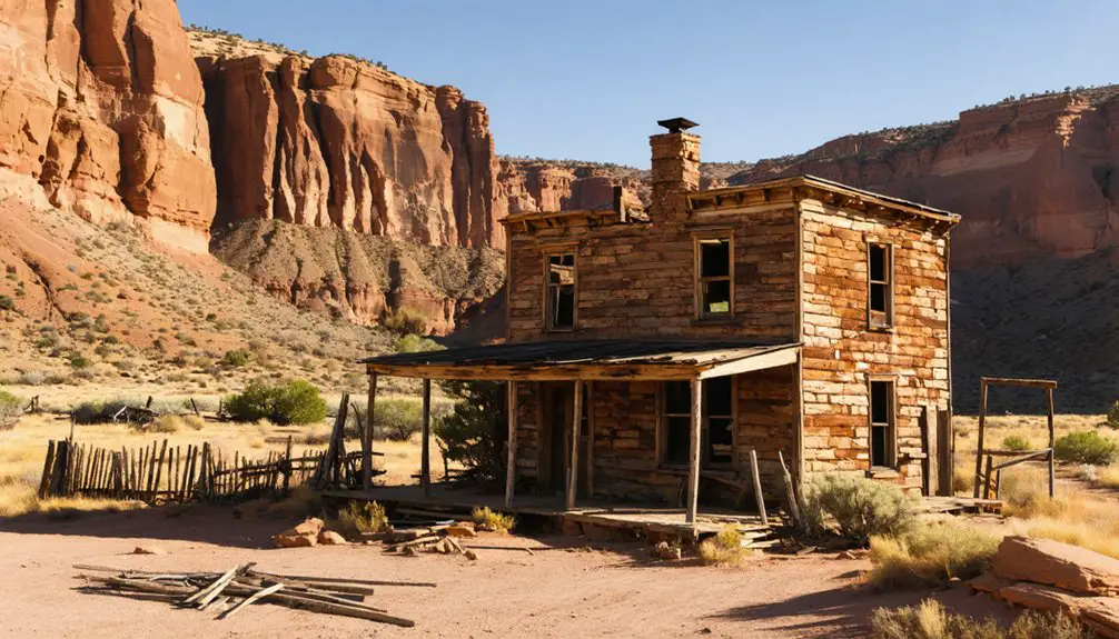
You’ll find traces of daily life in the decaying hotel, schoolhouse, and animal shelters that hint at the town’s former liveliness.
While ghost stories are scarce, the physical evidence reveals a typical railroad town’s narrative – transient workers, commercial activity, and social connections centered around the train depot.
The 1942 removal of tracks during World War II marked the final chapter for Low’s railroad era, leaving behind only silent reminders of frontier ambition along the historic transcontinental corridor.
Preserving Low’s Historical Footprint
Despite the ravages of time, dedicated preservation efforts have transformed Low into an essential archaeological site for studying Utah’s railroad heritage. Through careful historical documentation, researchers have unearthed artifacts that tell compelling stories of life along the abandoned rails.
You’ll find volunteer teams working alongside professional archaeologists, cataloging discoveries and stabilizing remaining structures using period-appropriate techniques.
Community engagement plays an important role in Low’s preservation, with local organizations partnering to protect this cultural treasure. You’re welcome to join guided tours that showcase archaeological findings while maintaining controlled site access.
The town’s inclusion in preservation registries has secured critical legal protections and funding opportunities, ensuring that future generations can explore this monument to Utah’s pioneering spirit. Through these combined efforts, Low’s historical significance endures as a window into America’s railroad past.
Modern Day Remnants and Access
The physical remnants of Low today offer a stark contrast to its preservation efforts. You’ll find only foundational structures, scattered mining equipment, and deteriorating railway tracks marking this historic location.
Modern accessibility requires high-clearance vehicles, as unpaved roads from Delta, Utah provide the main access route.
For visitor safety and ideal exploration, consider:
- Bring adequate water and sun protection, as there’s minimal shade
- Check weather conditions, as roads become hazardous during rain or snow
- Monitor cell phone coverage, which can be unreliable
- Watch for wildlife, including snakes and coyotes
Without formal amenities or guided tours, you’re free to explore the site independently. However, unstable structures and mining hazards demand careful navigation.
The nearest services, including accommodations and visitor information, are available 15-20 miles away in Delta.
Frequently Asked Questions
Are There Any Known Accidents or Deaths Associated With Low’s Railroad Operations?
You won’t find specific railroad safety incidents recorded at Low itself, though operational risks were common on the nearby Lucin Cutoff, where the deadly 1944 Bagley wreck claimed 48 lives.
What Wildlife Species Commonly Inhabit the Abandoned Town Site Today?
Like ghosts haunting forgotten halls, you’ll find mule deer, coyotes, and various bats making their home in Low’s crumbling structures, while desert bighorns and raptors frequent the surrounding wilderness.
Did Any Notable Historical Figures Ever Visit or Pass Through Low?
You won’t find records of any famous visitors at this site. Historical significance centered solely on railroad operations, with no documented stops by notable figures during Low’s 75-year existence.
What Specific Buildings or Structures Were Originally Present in Low?
Like a frontier tapestry, you’d find historic architecture including stone houses, beehive kilns, iron furnaces, and community infrastructure comprising a boarding house, general store, butcher shop, post office, and schoolhouse.
Were There Any Schools or Churches Established During Low’s Operational Years?
You won’t find any schools or churches in Low’s history – it was strictly a railroad maintenance camp without the community significance typically marked by educational or religious buildings.
References
- https://en.wikipedia.org/wiki/Low
- https://www.youtube.com/watch?v=NhAtp2KTE3Q
- https://kids.kiddle.co/Low
- https://www.visitutah.com/articles/get-your-spooky-on
- https://utahguide.com/utah-ghost-towns-and-mining-towns/
- http://cprr.org/Museum/Stewart-Iron_Trail.html
- https://www.onlineutah.com/lowhistory.shtml
- https://utahrails.net/articles/weber-echo.php
- https://www.uen.org/utah_history_encyclopedia/r/RAILROADS.shtml
- https://utahrails.net/wp/wp-in-ut.php


