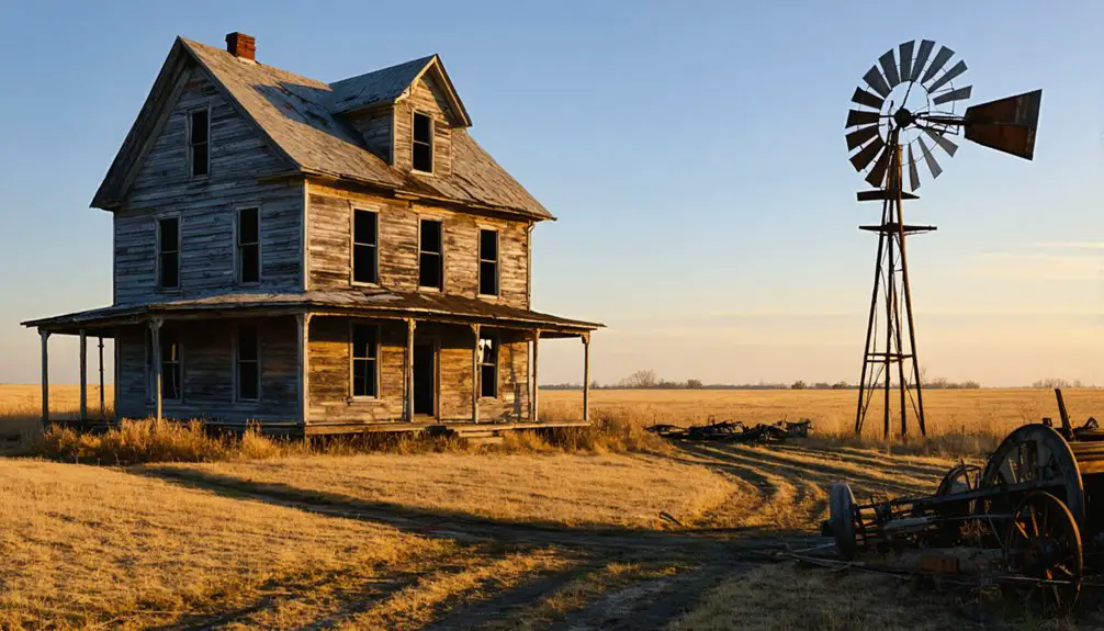
You’ll find Mayberry, Nebraska’s remains along the old Rock Island Railroad line, where Charles N. Mayberry established this frontier settlement in the late 1800s. The town’s post office opened in 1884, serving farming families who built their lives around Tekamah Creek’s fertile plains. Today, scattered foundations, domestic artifacts, and weathered structures mark where ambitious pioneers once thrived. The site’s archaeological treasures and preserved records reveal an untold story of Great Plains settlement life.
Key Takeaways
- Mayberry was established in the 1880s as a frontier settlement named after Charles N. Mayberry, with a post office opening in 1884.
- The town’s development was centered around the Rock Island Railroad, which served as a vital transportation link for the community.
- Water scarcity played a crucial role in Mayberry’s decline, as settlers struggled with limited access to reliable water sources.
- Archaeological remains include structural foundations, scattered domestic debris, and degraded transportation features from the 19th and early 20th centuries.
- The site now exists as a ghost town, with preservation efforts focused on protecting remaining landmarks and documenting its pioneer history.
The Pioneer Legacy of Charles N. Mayberry
Although many pioneer settlers helped shape Nebraska’s landscape in the late 19th century, Charles N. Mayberry left an indelible mark that you can still trace today. His pioneer contributions extended beyond mere settlement, as he helped establish the foundational framework that would sustain the community bearing his name.
You’ll find his influence woven into the early infrastructure and community organization that defined Mayberry’s development. When locals needed a name for their settlement, they chose to honor Mayberry’s pioneering spirit and dedication to building their shared future. Similar to the founding of John Mayberry’s town, the Nebraska settlement preserved its founder’s name as a testament to his vision. Like many who lived in Beatrice, Nebraska, he dedicated himself to strengthening local community ties.
His legacy lives on through historical documentation and the very identity of the place he helped create. As one of the area’s first settlers, Mayberry’s impact on Pawnee County’s development exemplifies the determination and vision that characterized Nebraska’s frontier expansion.
Early Settlement and Exploration
When the first pioneers ventured into what would become Mayberry, they encountered a landscape rich with promise and natural resources. Early exploration parties, led by scouts like Maynard and White, moved west along the Elkhorn River before turning north in search of ideal settlement sites. The pioneers followed similar westward migration patterns as the estimated 500,000 travelers who moved across the continent between 1841 and 1866. The development of the area was further shaped by the Rock Island Railroad that would later become a central feature of the community.
The area’s first recorded claim came from Bartholomew in 1856, followed by David Neal and Henry Musfeldt in 1857. Settlement patterns emerged around crucial resources, particularly the dense timber tracts near Tekamah Creek that you’d need for building.
George Tanner blazed the trail as the first permanent settler in 1859, establishing his cabin near Mission Creek Church. You’ll find the community’s earliest foundations in the shared sacrifices of these pioneers, from Abe Manley’s cemetery land donation to the gradual development of fundamental services like the post office.
Natural Resources That Shaped the Town
Located at the edge of fertile plains, Mayberry’s natural resources proved vital to its early development, with rich soil supporting diverse agricultural endeavors from grain cultivation to livestock farming.
You’ll find evidence of the town’s strategic positioning near water sources, which provided critical irrigation for farming while enabling trade connections through river transport.
The abundant local timber supplied settlers with vital building materials and fuel, allowing them to construct homes, barns, and other structures necessary for establishing a foothold in the region.
Timber’s Role in Settlement
Because timber availability played a vital role in early settlement patterns, Mayberry’s establishment likely hinged on the region’s abundant hardwood forests, particularly its cottonwood stands.
These timber resources provided essential economic incentives for early settlers, supporting both immediate construction needs and long-term industrial development. Like the South’s dramatic shift in the 1880s logging expansion, Nebraska’s forests became increasingly important for regional development. Similar to how German immigrants transformed Oak Harbor from lumbering to farming, Mayberry’s economy evolved with changing resource demands.
You’ll find that Nebraska’s robust timber industry shaped Mayberry’s early growth through:
- Access to 57 regional sawmills that processed local hardwoods
- Employment opportunities in logging and milling operations
- Ready availability of building materials for homes and structures
- Development of transport networks to move forest products
When you consider that 89% of Nebraska’s processed roundwood came from hardwood species, you can understand how Mayberry’s proximity to these forest resources made it an attractive settlement location for pioneers seeking opportunity and self-sufficiency.
Water Sources and Growth
Despite its strategic location within Nebraska’s vast network of waterways, Mayberry faced significant water challenges that shaped its early development and eventual decline.
Much like native plants that must adapt to extremes, settlers were forced to modify their water usage habits to survive the region’s harsh conditions. You’ll find early settlers hauling water from distant springs at twenty cents per barrel, while others relied on stagnant prairie creek pools during dry seasons. Water scarcity forced residents to adapt through rain barrels and spring houses, though mud contamination remained a persistent threat.
The limited water supply directly impacted agricultural efficiency, as farmers struggled with seasonal spring depletions and labor-intensive water hauling. Like the exposed remnants at Lake McConaughy, drought conditions revealed traces of Mayberry’s original water collection systems.
While some prosperous residents constructed better storage solutions, the town’s growth remained constrained by its water challenges. These persistent difficulties in securing reliable water sources ultimately contributed to Mayberry’s transformation into the ghost town you’ll discover today.
Fertile Plains Location
While many Nebraska ghost towns faded due to harsh conditions, Mayberry’s fertile plains initially promised agricultural prosperity. The town’s location offered rich mollisol soils that could support diverse crops and sustainable agricultural practices. Located in Election Precinct 4, the town benefited from organized agricultural planning and communal farming initiatives.
The history of Bookwalter, Nebraska, reveals similar struggles and triumphs as Mayberry, where the promise of growth was often met with the forces of nature. Founded around the same time, Bookwalter thrived on its close-knit community and shared commitment to cultivating the land. As both towns evolved, they faced the inevitable challenges of modernization while holding onto their agricultural roots.
You’ll find these natural advantages that drew settlers to Mayberry’s promising landscape:
- Deep, nutrient-rich soils perfect for growing corn, wheat, and soybeans
- Native tallgrass prairie that provided excellent grazing for livestock
- Gently rolling topography around 1,100 feet elevation that prevented erosion
- Semi-humid climate with reliable rainfall patterns ideal for farming
The land’s natural fertility, combined with abundant wildlife and indigenous plants, created a self-sustaining ecosystem that supported both traditional farming methods and innovative agricultural practices. With a similar rustic appeal to the east coast estate discovered on Leavenworth Street, Mayberry’s early architecture reflected its agricultural heritage.
These conditions made Mayberry an attractive settlement choice for those seeking independence on the Great Plains.
Life Along Tekamah Creek
You’ll find the earliest settlers along Tekamah Creek strategically positioned their homesteads near the convergence of smaller forks, taking advantage of both water access and protective timber groves.
Your journey through this area would reveal how they utilized the creek’s rich resources, from the workable sandstone that hardened into building materials to the fertile soils that supported their agricultural endeavors.
The creek’s reliable water flow and surrounding hardwood forests provided these pioneers with essential resources for survival, from drinking water to building materials and fuel.
Creek Settlement Patterns
As settlers ventured into Nebraska Territory in 1854, they strategically positioned their homesteads along Tekamah Creek, drawn by its abundant water supply and fertile soil in the Missouri River Valley.
The creek ecosystems supported settlement sustainability through access to essential resources and fertile bottomlands for farming.
You’ll find these pioneering families established their presence in distinct patterns:
- Major settlements clustered near creek junctions and along the old stage road
- Homesteads spread along waterways including Bell Creek and Silver Creek
- Notable families like the Skieners, Truaxes, and Critchfields chose creek-adjacent farmland
- Settlers utilized local sandstone quarries near the creek for building materials
The dispersed settlement pattern you see reflected both the settlers’ need for water access and their desire to maintain independent agricultural operations throughout the region.
Natural Resources Impact
The strategic positioning of settlers along Tekamah Creek would later prove challenging for sustainable resource management.
You’ll find that today’s water conservation efforts reflect the complex legacy of these early settlement patterns, as groundwater levels continue dropping while agricultural demands increase.
When you explore the area now, you’ll notice how the Nemaha Natural Resources District endeavors to maintain ecological balance through careful monitoring of both surface and groundwater resources.
They’re battling against drought conditions, agricultural runoff, and rising nitrate levels.
The creek’s waters, which once attracted settlers, now require intensive management to support local farming, drinking water needs, and the region’s biodiversity.
Summit Lake State Recreation Area stands as a reflection of what’s at stake – a delicate balance between human use and environmental preservation.
The Founding Families and Their Stories
Pioneer settlers of Mayberry traced their roots to Charles N. Mayberry, whose family’s influence helped establish this Nebraska community in the mid-1800s.
Through family anecdotes and settlement challenges, you’ll discover how these determined pioneers shaped the early social fabric of Pawnee County.
- The Mayberry family’s dedication led to the establishment of the local post office in 1884, marking a vital milestone in the town’s development.
- George Tanner, building the first permanent cabin in 1859, set the foundation for future growth.
- Early settlers like Bartholomew, Neal, and Musfeldt filed land claims between 1856-1857.
- Abe Manley and Thomas Clark joined the community in the 1860s, contributing to its expansion.
These founding families worked together, creating churches, maintaining cemeteries, and building the infrastructure that would define Mayberry’s early years.
Mapping Mayberry’s Historical Location
While modern maps struggle to pinpoint exact coordinates, Mayberry’s historical location centers near 40.06°N latitude and -96.31°W longitude in southeastern Nebraska’s Pawnee County.
You’ll find it close to the village of Steinauer, surrounded by the gentle plains and farmlands that characterize this region.
Achieving historical accuracy in mapping Mayberry presents several challenges. The ghost town‘s physical remnants have largely disappeared, and early topographic maps often omitted small hamlets like this one.
Tracing lost ghost towns poses unique mapping challenges, as time erases physical evidence and historical maps exclude these tiny settlements.
Today’s mapping challenges include natural landscape changes, overgrown vegetation, and limited road access.
While digital databases and GPS coordinates provide general reference points, you’ll need to dig deeper into county archives, historical plat maps, and local historical societies to uncover Mayberry’s precise boundaries and original layout.
From Thriving Settlement to Ghost Town
Emerging from humble beginnings in 1859 with George Tanner’s solitary cabin, Mayberry quickly blossomed into a vibrant frontier settlement.
Pioneer families like the Manleys, Clarks, and Bowhays carved out their destinies here, establishing essential community foundations.
You can trace Mayberry’s journey from thriving town to abandonment through these key developments:
- W.J. Halderman’s store opening in 1870 marked the start of commercial growth
- The post office’s establishment in 1884 signaled community prosperity
- Early 20th century urbanization triggered population shifts away from rural areas
- The post office’s closure in 1934 marked the final stage of community decline
While Mayberry’s physical presence has faded, its cemetery remains as a silent tribute to the dreams and determination of those who once called this frontier town home.
Preserving Mayberry’s Heritage
You’ll find the careful restoration of Mayberry’s historical documents, including land deeds and town meeting minutes, now preserved in the Tribal Historic Preservation Office’s digital archives.
Local preservation teams have implemented protective measures at key landmark sites, including the installation of weather-resistant interpretive markers and structural reinforcement of the remaining mercantile building.
Through partnerships between the THPO and community volunteers, you can access detailed maps and photographs of Mayberry’s original layout in both physical archives and online databases.
Historical Document Restoration
The painstaking work of preserving Mayberry’s historical documents reflects a deep commitment to safeguarding the town’s legacy for future generations.
Through professional document conservation techniques, you’ll find Mayberry’s precious records undergoing careful restoration and digital archiving to guarantee their survival.
Here’s what’s being done to protect these irreplaceable pieces of history:
- Stabilizing and cleaning original documents using specialized tools and deacidification
- Creating high-resolution digital copies with enhanced legibility through AI-driven technology
- Storing materials in climate-controlled facilities with precise temperature and humidity controls
- Implementing customized preservation plans that combine both physical restoration and digital safeguarding
You’ll appreciate how these thorough preservation efforts are making Mayberry’s historical documents more accessible while protecting them for decades to come.
Landmark Site Protection
While time has gradually eroded many of Mayberry’s original structures, dedicated preservation efforts now focus on protecting the town’s remaining landmarks, including the historic Dunlap Mercantile and brick remnants of the old train depot.
You’ll find historical markers along Highway 74 that help tell the story of this vanished prairie town, though landmark conservation faces ongoing challenges from nature’s steady encroachment.
The Table Rock Historical Society leads preservation initiatives, documenting the site’s surviving features and advocating for enhanced protection measures.
Without formal historic designation, you’re witnessing preservation challenges that include weathering, vandalism, and limited funding options.
Yet opportunities exist to secure the town’s heritage through partnerships with state organizations and potential inclusion on historic registers, ensuring these tangible connections to Nebraska’s past endure for future generations.
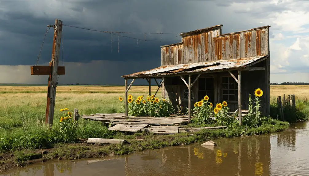
Archaeological Significance and Remains
Located on Nebraska’s windswept plains, Mayberry’s archaeological remains offer compelling insights into late 19th and early 20th-century frontier settlement patterns.
While few visible structures remain today, buried cultural artifacts beneath the soil tell a fascinating story of pioneer life. Archaeological findings suggest significant potential for preserved materials in the area’s Bayard terrace soils.
Hidden beneath Nebraska’s prairie soil, artifacts whisper stories of pioneer struggles, preserved for generations in the rich Bayard terraces.
You’ll discover evidence of frontier life through:
- Scattered domestic debris including ceramic fragments and glass shards
- Structural foundations and cellar holes marking former building sites
- Degraded transportation features like old road traces and rail beds
- Subsurface deposits containing diagnostic cultural materials from the settlement period
These archaeological clues, when combined with historical records, paint a vivid picture of this once-thriving frontier community’s brief but significant existence.
Impact on Nebraska’s Settlement History
Beyond its buried artifacts and structural remnants, Mayberry’s significance stretches deep into Nebraska’s settlement narrative.
You’ll find its story woven into the broader tapestry of pioneer infrastructure development, from its crucial 1884 post office to its role as a rural connectivity hub for isolated farming families.
When you examine Mayberry’s impact, you’ll notice how it exemplified the typical life cycle of Plains settlements.
The community’s rise supported the transformation of prairie into farmland, while its eventual decline mirrors the challenges that faced countless small towns.
Through Charles N. Mayberry’s namesake settlement, you can trace the evolution of frontier communities and understand how these small outposts shaped Nebraska’s development, even after they’ve faded into ghost town status.
the historical significance of koesterville extends beyond its physical remnants, as it represents the resilience and innovation of early settlers in a challenging environment. Exploring the stories of its inhabitants reveals how their struggles and triumphs contributed to the broader narrative of American westward expansion. As you walk the remnants of the settlement, you can almost hear the echoes of the past, reminding us of the indelible mark these communities left on the tapestry of Nebraska’s history.
Frequently Asked Questions
When Was the Last Known Resident Recorded Living in Mayberry?
You won’t find precise records of Mayberry’s last resident in documented history. The town’s population gradually declined through the 20th century, with no known inhabitants remaining well before the late 1900s.
Are There Any Surviving Structures or Foundations Still Visible Today?
Time has taken its toll – you’ll find few surviving buildings beyond deteriorating coal shafts. The historical remnants are minimal, with only faint traces of earth-based foundations barely visible today.
What Caused the Initial Decline of Mayberry’s Population?
You’ll find the population dwindled primarily due to a devastating economic downturn when investors abandoned overpriced lots. Without sustained capital backing, residents couldn’t weather the collapse and left seeking better opportunities.
Did Mayberry Ever Have a Post Office or General Store?
You’ll find records showing historic commerce centered around a post office that operated from 1884 to 1934, though community services like a general store aren’t clearly documented in available sources.
What Was the Peak Population of Mayberry During Its Most Prosperous Years?
You’ll find that population growth reached about 100 residents during peak prosperity, influenced by economic factors like agricultural development and postal services during the late 19th to early 20th century.
References
- https://www.seekingmyroots.com/members/files/H005126.pdf
- https://www.tablerockhistoricalsociety.com/other-towns.html?view=full
- https://www.youtube.com/watch?v=CChgVytSCRc
- https://kids.kiddle.co/Mayberry
- https://en.wikipedia.org/wiki/List_of_ghost_towns_in_Nebraska
- https://en.wikipedia.org/wiki/Mayberry
- https://history.nebraska.gov/wp-content/uploads/2017/12/doc_publications_NH1978PerkeysMorrill-Scottsbluff.pdf
- https://ghchapel.com/obituaries/shirley-bratt
- https://www.familysearch.org/library/books/records/print?search=mayberry&sort=_score&perpage=10&page=1
- https://www.familysearch.org/en/wiki/Pawnee_County


