McLeans Ferry, established during California’s 1848 Gold Rush, served as an essential Stanislaus River crossing point where Coyote Creek joins the waterway. You’ll find this abandoned settlement in the Sierra Nevada foothills, where it once buzzed with miners, stagecoaches, and commerce. The McLean family operated this significant transport link between counties until bridges and railroads rendered it obsolete. The site’s remaining structures—schoolhouse, store, and church—tell stories of boom, bust, and the transient nature of Gold Rush prosperity.
Key Takeaways
- McLeans Ferry originated during the 1848 California Gold Rush as a vital crossing point on the Stanislaus River for prospectors.
- The settlement expanded from a ferry crossing into a mining hub with trading posts, hotels, and notable gold mines.
- Located where Coyote Creek meets the Stanislaus River, it served as a supply distribution center with stagecoach connections.
- The town declined when bridges and railroads made ferries obsolete, leading to its eventual abandonment.
- Today, visitors can explore original structures like the schoolhouse, store, and church that showcase California’s mining heritage.
The Gold Rush Origins of McLeans Ferry
When gold was discovered at Sutter’s Mill in 1848, the news sparked a migration that would transform California’s landscape, with McLeans Ferry emerging as one of countless settlements born from this fevered rush.
You’d have found this settlement strategically positioned along the Stanislaus River, where it quickly became essential to prospectors heading into the Sierra Nevada foothills.
McLeans Ferry wasn’t planned—it sprang up organically as miners flooded the region, creating an instant need for river crossings and supply points.
The settlement formed rapidly, as did many Gold Rush communities, with its existence entirely dependent on the precious metal drawing thousands westward.
The Stanislaus waterway determined the ferry’s location, and this crossing point became the settlement’s reason for being—a classic example of how California’s Gold Rush reshaped the territory’s geography overnight.
Like many boomtowns that emerged during this period, McLeans Ferry experienced dramatic population growth as hundreds of thousands of migrants arrived seeking fortune in the newly ceded territory.
The ferry system established here was part of a larger network that developed along the Stanislaus, San Joaquin, and Tuolumne Rivers, enabling crucial transportation for miners and supplies in the growing region of Southern Mother Lode.
Life Along the Stanislaus River Crossing
Nestled at the strategic junction where Coyote Creek meets the Stanislaus River, McLeans Ferry hummed with the constant activity of a significant crossing point during the Gold Rush era.
You’d witness daily stagecoaches arriving at the water’s edge, connecting this riverside settlement to Stockton and neighboring ferry towns like Byrne’s and Taylor’s near Oakdale.
The river’s ecology shaped every aspect of community life. Before European settlement, this area was part of the ancestral lands where Miwok Native Americans lived for over 10,000 years. Miners built simple cabins and tents near sandbars perfect for gold panning, while the waterway provided both drinking water and the means for extraction operations.
Transportation routes converged at the ferry crossing, transforming it into a supply distribution hub complete with trading posts and hotels.
The limestone canyon walls constrained settlement growth but created a distinctive landscape that defined this fleeting but essential community along the Stanislaus transportation network.
Mining Operations and Economic Boom
Although McLeans Ferry began as a river crossing, the allure of gold transformed this small settlement into a bustling mining hub by the late 19th century.
Pioneers like George Fitch, Oliver Britt, and George Blazer prospected areas such as Ramsey Flat and Scorpion Gulch, seeking fortune in the earth’s depths.
The mining technology evolved rapidly, with stamp mills crushing ore while mercury amalgamation extracted precious metals.
Grinding stamps pounded day and night while mercury captured gold particles, revolutionizing extraction methods across the mining district.
Vertical shafts plunged 600 feet underground, and hydraulic “giants” washed away gravel banks.
The economic impact was significant—mines like Blackhawk yielded approximately $700,000 in gold before World War II halted operations.
The Alto Mine, which operated from 1897 to 1906, was a particularly productive operation, generating nearly $1 million in gold during its peak years.
This success mirrored the broader Gold Rush phenomenon, where California’s annual gold output reached hundreds of millions in value following the initial discoveries at Sutter’s Mill.
As gold’s profitability waned, the region diversified into tungsten and asbestos mining.
The Jefferson Lake Sulphur Company’s operation processed 2,500 tons daily until health concerns ended the asbestos boom in the 1980s.
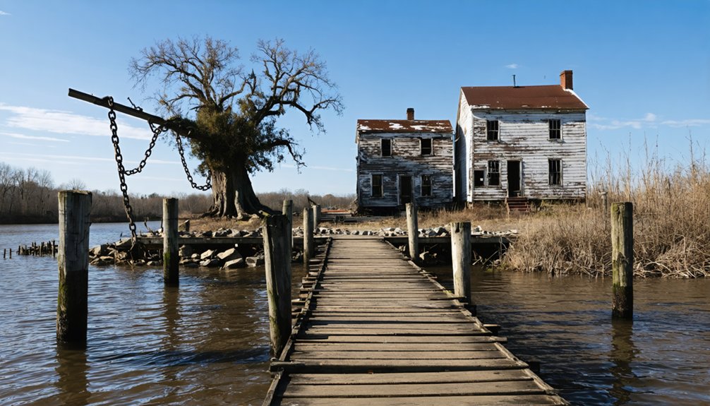
From Bustling Crossing to Abandoned Settlement
Originally established as an essential crossing point on the Stanislaus River in Calaveras County, McLeans Ferry transformed from a simple riverside operation into a thriving settlement during California’s gold-fueled expansion.
The ferry operations, managed by the McLean family, created the best-travelled route connecting Calaveras and Tuolumne counties, fostering significant commerce between mining regions.
The settlement dynamics shifted dramatically as the century progressed. You’d have witnessed the gradual deterioration as bridges and railroads rendered the ferry obsolete. Similar to how the ship Rosalie was discovered completely abandoned in 1840 with cargo intact but crew mysteriously vanished, many buildings in McLeans Ferry stood intact but empty as residents departed.
Floods and erosion attacked the physical structures while economic opportunities disappeared. Where miners, traders and travelers once gathered to exchange news and supplies, nature reclaimed the land. McLeans Ferry represents the economic decline typical of California ghost towns, where prosperity vanished when the local resource-based economy collapsed.
Visiting the Historic Remains Today
Reaching McLeans Ferry today requires a sense of adventure and a vehicle equipped for rough terrain. The 7-mile mountain road leading to this remote settlement demands off-road capabilities, especially when maneuvering toward the brick remnants along Highway 299w.
Once there, you’ll discover a living museum where original structures—the schoolhouse, employee housing, store, and church—have been furnished with authentic period pieces. Like Shasta State Historic Park, the site features fascinating historical memorabilia that tells the story of frontier life. Much like Parisa’s early challenges, the isolated location made medical care almost inaccessible to residents during the town’s heyday. Knowledgeable guides offer tours highlighting the site’s historical significance as part of California’s mining heritage.
The history of Melones, California, is marked by its gold rush beginnings and the diverse community that flourished during that era. Visitors can explore artifacts that showcase the daily lives of those who settled in this rugged region, as well as the challenges they faced. Each exhibit tells a unique story, contributing to the rich tapestry of California’s mining past.
For meaningful visitor tips: bring supplies, as amenities remain scarce; check weather forecasts, as thunderstorms can create both hazardous conditions and an eerily authentic frontier atmosphere; and plan your expedition during daylight hours.
The ongoing restoration efforts make McLeans Ferry a raw, unfiltered glimpse into California’s rugged past.
Frequently Asked Questions
Who Was Mclean and When Did He Establish the Ferry?
McLean, whose full identity remains sparse in records, established Griffin’s Ferry on the Tuolumne River in February 1850. You’ll appreciate his ferry operations as McLean’s legacy during California’s Gold Rush.
Were There Any Notable Crimes or Outlaws at Mcleans Ferry?
Finding formal facts about outlaw encounters is frustratingly difficult. You won’t discover documented crime history specific to McLeans Ferry, though the Tuolumne County settlement likely experienced typical gold rush lawlessness.
What Happened to the Ferry During Seasonal Floods?
During seasonal floods, you’d find ferry operations suspended as rising Sacramento River waters damaged docks and washed away infrastructure. You couldn’t cross for weeks while operators struggled with flood damage to landing points.
Did Any Famous Gold Rush Figures Visit Mcleans Ferry?
You’ll find no historical record of famous Gold Rush figures visiting McLeans Ferry specifically. Unlike Sacramento or San Francisco, this small Stanislaus River crossing primarily served everyday miners rather than notable personalities.
Were There Conflicts With Native American Tribes Near Mcleans Ferry?
Walking on eggshells, you’ll discover that bitter Native American Relations erupted at McLeans Ferry, where Historical Conflicts with Wiyot and Athabaskan tribes intensified after 1850’s Trinity River gold rush disrupted their ancestral lands.
References
- https://discover.hubpages.com/travel/Ghost-Towns-in-California
- https://cagenweb.org/books/History of Tuolumne County.pdf
- https://core.ac.uk/download/pdf/303914983.pdf
- https://www.calaverashistory.org/files/dcbbdb072/1979+Oct+Las+Calaveras+MELONES.pdf
- https://www.stancounty.com/publicworks/pdf/projects/hickman-road-over/archaelogical-survey-report.pdf
- https://dot.ca.gov/-/media/dot-media/programs/environmental-analysis/documents/ser/work-camps-a11y.pdf
- https://online.norwich.edu/online/about/resource-library/historical-impact-california-gold-rush
- https://kids.kiddle.co/McLeans_Bar
- https://www.cerescourier.com/news/local/countys-early-river-ferry-towns-didnt-survive/
- https://en.wikipedia.org/wiki/California_gold_rush


