You’ll find Nebraska’s mining ghost towns emerged from specialized extraction operations rather than traditional gold or silver rushes. Antioch boomed to 5,000 residents by 1918 extracting potash from Sandhills alkali lakes during WWI’s German supply disruption. Minersville’s coal mining ended after an 1901 shaft collapse killed most workers, while Ingham processed volcanic pumice along the Burlington railroad until the 1920s farming crisis. Oreapolis existed only as Dr. John Evans’s 1857 paper town that never materialized beyond promotional materials, though each site’s remnants reveal distinct chapters in Nebraska’s mineral extraction history.
Key Takeaways
- Antioch boomed to 5,000 residents during WWI as the American Potash Company extracted potash from Sandhills alkali lakes.
- Minersville’s coal mining operations ended after an 1901 shaft cave-in killed all workers except fourteen.
- Ingham thrived from 1886 extracting volcanic pumice for scouring powder until milling operations ceased by 1950.
- Grant County settlements failed due to fraudulent land surveys, inadequate homestead sizes, and sand blow conditions.
- Oreapolis existed only as a paper town from 1859-1864, with promised urban development never materializing.
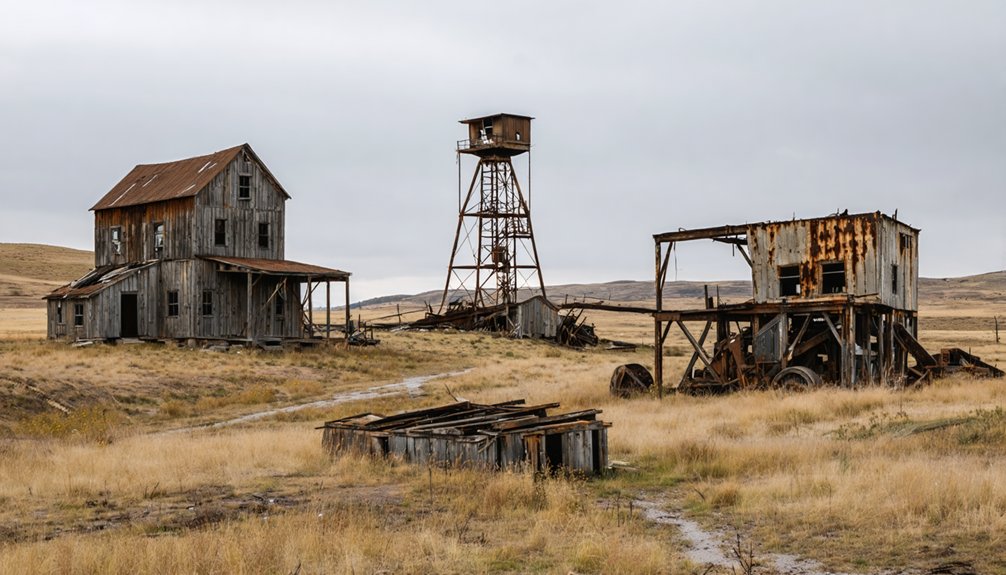
Antioch: Nebraska’s World War I Potash Capital
When World War I severed America’s supply of German potash in 1915, entrepreneurs turned their attention to Nebraska’s Sandhills, where alkali lakes harbored abundant deposits of this critical resource. University of Nebraska chemists developed extraction methods that enabled the American Potash Company‘s formation in 1916.
By spring 1918, five plants operated near Antioch, transforming this frontier outpost into a boomtown of 2,000-5,000 residents. The mining techniques involved pumping brine from lakes to railroad-adjacent reduction plants, where innovative evaporating towers processed the material. The extracted potash served as a component of fertilizer for cotton production in the southern states. Beyond agricultural applications, potash was essential for producing epsom salts and soda. These social impacts proved short-lived—German imports flooded markets after armistice, forcing plant closures by 1921.
Today, you’ll find fewer than twenty-five residents among the ruins, though historical markers commemorate this brief industrial surge that once made Antioch Nebraska’s potash capital.
Minersville’s Rise and Fall in Southeast Nebraska
While potash operations transformed Antioch in Nebraska’s Sandhills, coal deposits drew settlers to Minersville in Otoe County’s rolling terrain south of Nebraska City. You’ll find this mining hub emerged during the regional boom, establishing a post office that served residents until February 15, 1923.
Settlers from Pennsylvania and Indiana conducted farming shifts alongside mining work throughout the 1860s, while religious services nearby began in 1857 along Camp Creek. The town’s prosperity shattered in 1901 when a catastrophic shaft cave-in killed all but fourteen workers.
As mining activities declined, Minersville’s commercial district—including mercantile operations and administrative offices—fell silent. The area was organized into Minersville Precinct, establishing formal administrative boundaries for local governance. Today, only scattered structures mark where this once-bustling community stood, earning its designation as an authentic Nebraska ghost town. The deteriorating coal shafts remain visible reminders of the mining operations that once drove the local economy.
Ingham’s Silica Industry Along the Railroad
The Chicago, Burlington and Quincy Railroad‘s 1886 establishment of Ingham at the tracks crossing Deer Creek Canyon created an unusual hybrid settlement—part agricultural way station, part industrial mining hub.
You’ll find that regional silica demand drove the LaRue-Axtell Company‘s operations, extracting volcanic pumice from a concentrated square-mile deposit for scouring powder production. The Axtell brothers’ mill processed two weekly carloads through large drying drums and screens, shipping to eastern firms, Canada, and western markets for soap, cleansers, and paint applications.
Milling operations challenges intensified during the late 1920s as marginal dryland farming profits collapsed. When the silica mill relocated to Eustis in 1928, Ingham’s economic foundation crumbled. The settlement also supported small dryland farms and cattle ranches that relied on it as a trading center. The town shared its name with Ingham County, Michigan, though Nebraska’s mining settlement remained far smaller than its midwestern counterpart. By 1950, only foundations and wagon remnants marked where industry once thrived—memorialized by Nebraska State Historical Marker #286.
Settlement Struggles in Grant County’s Sandhills
Initially dismissed as “worthless sandhills” during October 1876 surveys of south-central Grant County, this 13-million-acre expanse—the western hemisphere’s largest stabilized sand dune system—proved hostile to conventional settlement patterns that succeeded elsewhere on the Great Plains.
Land survey challenges compounded settlement difficulties:
- The 1876 survey contained deliberate falsifications—hills mapped as valleys, missing section corners creating overlapping claims
- Resurvey demands from frustrated residents weren’t addressed until 1895, leaving legal chaos for nearly two decades
- The 1862 Homestead Act’s 160-acre allotments proved catastrophically inadequate for viable ranching operations
The absence of organized law enforcement transformed the region into a haven for outlaws and cattle rustlers during its earliest settlement years. Farming failures in sandhills intensified after 1904’s Kinkaid Act encouraged settlers to plow fragile grasslands. Sand blow forced farm abandonment, consolidating tracts into 50,000-acre ranches that dominate today’s landscape. A serendipitous 1879 incident—when cattle drifted into the Sandhills and thrived—ultimately revealed the region’s true agricultural potential as rangeland rather than cropland.
Oreapolis: The Paper Town That Never Was
From his Chicago office at 55 Clark Street, Dr. John Evans organized the Oreapolis Town Company on October 30, 1857, positioning his venture at the Platte and Missouri Rivers junction. He filed Articles of Incorporation in Cass County on September 29, 1858, completing surveys for two land sections by October.
Evans envisioned America’s largest urban center between Chicago and San Francisco, advertising ferry service, fifty houses, and construction of hotels, banks, and lumber yards. He predicted 1,000 inhabitants within two years.
Evans promised a metropolis rivaling Chicago and San Francisco, complete with hotels, banks, and a thousand residents within twenty-four months.
The town existed only from 1859 to 1864. No structures survived. Nebraska State Historical Society documents this ghost city in John Irwin’s 2020 article, exemplifying visionary plans’ unrealized potential. Like many Nebraska towns that became ghost towns when their main industry disappeared, Oreapolis failed because its promised economic foundation never materialized.
Settlement failure’s historical lessons remind you that ambitious frontier planning required more than speculation.
Frequently Asked Questions
What Safety Hazards Exist When Exploring Abandoned Mining Sites in Nebraska?
You’ll face unstable structures like rotting timbers and crumbling shafts, plus concealed hazards including hidden vertical drops, toxic gases, and submerged debris in water-filled areas—all documented as leading causes of injury and death at abandoned mine sites.
Are There Any Guided Tours Available for Nebraska’s Ghost Towns?
The dusty trails beckon you to explore independently—Nebraska offers primarily self-guided tours through its abandoned mining ghost towns, though Spirit Expeditions and US Ghost Adventures occasionally provide private tours for groups seeking expert-led paranormal expeditions.
Can Artifacts Legally Be Collected From Nebraska Ghost Town Sites?
You can’t legally collect artifacts from Nebraska ghost town sites without private landowner permissions, as they’re protected under state law regardless of visibility. Abandoned property regulations impose $2,000 fines for violations, protecting your exploration freedoms responsibly.
Which Nebraska Ghost Town Is Easiest to Access for Visitors?
Dobytown’s the easiest ghost town you’ll access, featuring historical markers near Fort Kearny State Park with walking paths just steps away. You’ll find clear signage and mapped directions, unlike remote sites requiring dirt roads through backcountry terrain.
What Caused Nebraska’s Mining Operations to Close Permanently?
Like veins running dry, you’ll find declining mineral reserves and lack of economic viability forced Nebraska’s mining operations to close permanently. Commodity price crashes (2015-2016), persistent agricultural downturns, and groundwater contamination risks ultimately sealed their fate.
References
- https://negenweb.us/knox/stories/ghosttowns.htm
- https://www.legendsofamerica.com/grant-county-nebraska/
- https://history.nebraska.gov/wp-content/uploads/2017/12/doc_publications_NH1937GhostTowns.pdf
- https://freepages.rootsweb.com/~gtusa/history/usa/ne.htm
- https://history.nebraska.gov/oreapolis-nebraskas-ghost-town/
- https://dawsonpower.com/2020/10/ghost-towns-a-look-at-our-past/
- https://en.wikipedia.org/wiki/Antioch
- https://visitnebraska.com/trip-idea/explore-7-authentic-ghost-towns-nebraska
- https://www.hmdb.org/m.asp?m=178812
- https://www.youtube.com/watch?v=FkVqVu-Njk4


