You’ll discover Monson’s ghostly ruins along modern-day trails in southern New Hampshire, where six pioneering families established the region’s first inland colonial settlement in the 1730s. Despite spanning 17,000 acres, this unique community lacked traditional town structures and eventually succumbed to isolation by 1770. Today, you can explore over 200 preserved acres featuring seven original homestead foundations, stone walls, and cellar holes that whisper tales of colonial life’s harsh realities.
Key Takeaways
- Monson was New Hampshire’s first inland colonial settlement, established in the 1730s but abandoned by 1770 due to isolation and infrastructure challenges.
- The settlement lacked traditional town elements like churches and schools, with only scattered homesteads connected by primitive trails.
- Seven original homestead sites remain marked by stone foundations and cellar holes across the 17,000-acre former settlement area.
- The ghost town’s core 200 acres are now preserved as a historic park with interpretive trails connecting the colonial home sites.
- Residents gradually relocated to neighboring towns like Milford and Hollis, leading to Monson’s territory being absorbed and identity erased.
The First Inland Colonial Settlement
When six families from Massachusetts and Nova Scotia ventured inland to establish Monson in the 1730s, they pioneered New Hampshire’s first inland colonial settlement. You’ll find their names – Gould, Wallingford, Nevins, Bayley, and Brown – among those who purchased land in 1735 and arrived two years later to build their homesteads.
The settlers faced significant settlement challenges in this untamed territory. Initially part of Massachusetts until 1741’s border adjustment, Monson grew to encompass over 17,000 acres. The area remained largely forgotten until historic preservation efforts began in 1998.
Carving out life in raw wilderness, these pioneers transformed 17,000 acres of untamed Massachusetts territory into New Hampshire’s early colonial frontier.
Despite the colonial lifestyle’s demanding nature, these families cleared land and constructed homes. At its peak, about 15 families called Monson home. However, the lack of central infrastructure, including a church or meeting hall, proved problematic. By 1770, the settlement was completely abandoned as residents departed due to various hardships.
The settlement’s only public structure was a pound for stray cattle.
A Town Without a Center
You’ll find no traditional New England town center when exploring Monson’s scattered remains, as the settlement lacked essential colonial infrastructure like a meetinghouse, church, or schoolhouse.
The community’s 15 families lived on separate homesteads connected by primitive trails, with only a cattle pound serving as communal property.
This dispersed settlement pattern, where homes spread across what’s now four modern towns, ultimately contributed to Monson’s failure as a viable colonial community by 1770. Today, visitors can explore the stone-lined cellar holes that mark where these original settler homes once stood. Initially established as fishing lodges, many structures were built near rivers to support British Empire interests.
Missing Public Infrastructure
Unlike most colonial New England settlements that centered around a meetinghouse or town common, Monson’s most striking feature was its complete lack of public infrastructure.
Without a central meeting house, church, or school, settlers couldn’t develop the public cohesion essential for a thriving colonial community. The only public structure you’d have found was a simple pound for stray livestock.
Governor Benning Wentworth’s repeated denials of requests to build public facilities deepened the town’s isolation. Today, visitors can explore the 3-mile trail system to see where these scattered homesteads once stood.
You’d have seen scattered homesteads instead of the typical village arrangement, with no main street or central plaza to foster communal identity. The rocky terrain made it nearly impossible to establish proper roads between settlements.
This dispersed settlement pattern, coupled with the absence of shared spaces for governance, worship, and education, ultimately contributed to Monson’s decline and eventual abandonment.
Failed Colonial Settlement Pattern
While most colonial New England towns developed around a clear central hub, Monson’s unusual settlement pattern doomed it from the start.
You’ll find that its 17,000 acres sprawled across what’s now multiple modern towns, with homesteads scattered far apart instead of clustering together. This dispersion created significant settlement challenges that undermined the colony’s stability.
Without a town center, Monson lacked the essential gathering places you’d expect in a colonial settlement – no meetinghouse, school, or church to anchor the community. Built between 1737 and 1770, the scattered homesteads reveal the town’s brief colonial existence.
The only public structure was a cattle pound, hardly enough to foster community cohesion. The isolated farmsteads may have offered independence, but they prevented the social bonds and shared infrastructure that helped other New England towns thrive.
Scattered Homesteads Only
The scattered homesteads of Monson painted a stark contrast to typical colonial New England settlements, with stone-lined cellar holes and foundations spread across 17,000 acres of what’s now modern-day southern New Hampshire.
You’ll find this dispersed living pattern defined Monson’s unique character, as settlers chose homestead isolation over traditional village life. Without a central meeting place, church, or schoolhouse, families carved out independent existences across the sprawling territory. The Gould home remains as the sole surviving structure from this era of isolated living.
Critical aspects of Monson’s scattered layout include:
- Individual farm plots separated by considerable distances
- No commercial or political hub to unite the community
- Transportation limited primarily to foot travel between homesteads
- Self-sufficient agriculture as the focus rather than communal activities
This pattern of isolated living ultimately contributed to Monson’s eventual abandonment, as loose social ties made it easier for residents to relocate.
Life in Early Monson
During the earliest years of settlement in Monson, between 1737-1770, six pioneering families from Massachusetts and Canada carved out a life in New Hampshire’s first inland colonial settlement.
You’d find social interactions centered around family homesteads rather than public spaces, as no churches, schools, or meeting halls were ever built. The Goulds, Wallingfords, Nevins, Bayleys, and Browns maintained strong family structures despite their isolation.
Daily life revolved around farming and livestock raising, with settlers working vast 17,000-acre expanses marked by stone walls. They’d rely heavily on the surrounding forests and wildlife for sustenance. The settlers had complex interactions with native Wabanaki tribes during these early years.
Though the harsh climate and poor planning eventually led to Monson’s decline, these determined families left an indelible mark on New England’s colonial history through their preserved homesteads and archaeological remains.
The Mystery Behind the Name
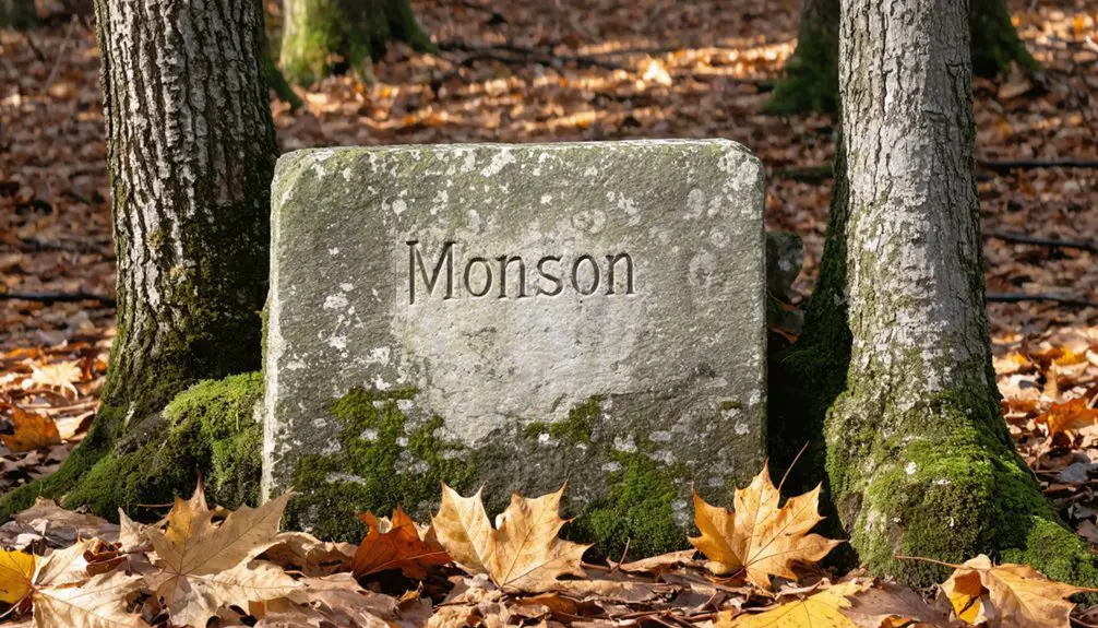
Why Monson received its distinctive name remains one of New Hampshire’s enduring colonial mysteries.
You’ll find various naming theories, but none provide definitive proof of the name’s origins. The settlement’s brief existence and border changes between Massachusetts and New Hampshire further complicated efforts to trace its etymology.
Historical research has revealed several possible explanations for Monson’s name origins:
- Connection to early settlers’ European homeland
- Derived from a prominent colonial family name
- Reference to local geographical features
- Tribute to an unknown founder or benefactor
While archaeologists have extensively studied the ghost town’s physical remains since 1998, they’ve uncovered no documents or artifacts that solve this colonial puzzle.
The mystery adds another layer of intrigue to this significant New England archaeological site.
The Path to Abandonment
Much like its mysterious name origin, Monson’s path to abandonment presents a compelling historical puzzle.
You’ll find a complex web of factors that led to the town’s demise around 1770, during a time of political upheaval in colonial America. While historians can’t pinpoint a single cause, you can trace the settlement’s decline through its lack of infrastructure and isolation from major centers.
Despite being New Hampshire’s first inland colony, Monson faced mounting challenges. Economic decline likely played a role as the small farming community, lacking formal roads or public buildings, struggled to maintain independence.
Rather than a sudden catastrophe, you’ll discover that residents gradually relocated to neighboring towns like Milford and Hollis, which ultimately absorbed Monson’s territory and effectively erased its identity from the map.
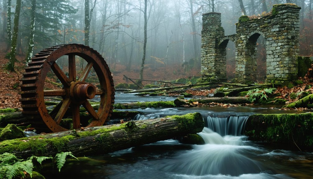
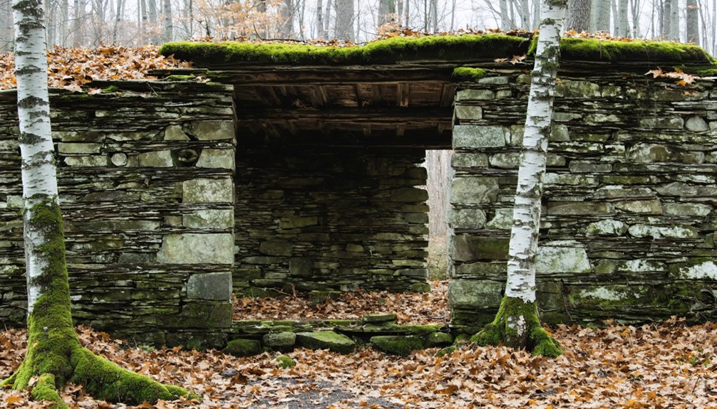
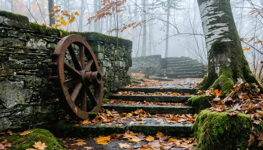
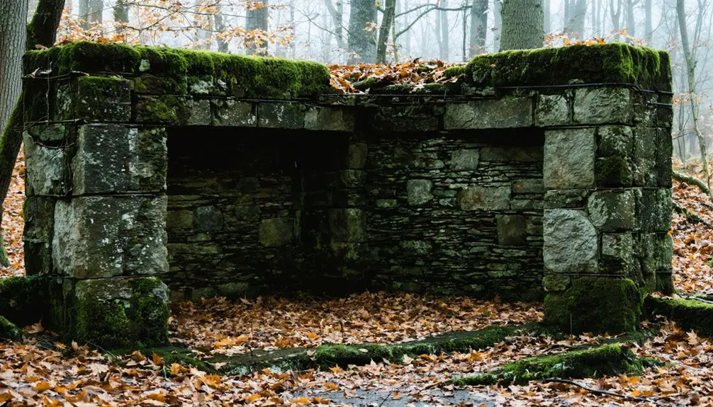
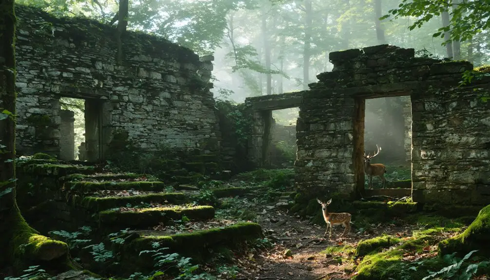
Archaeological Treasures
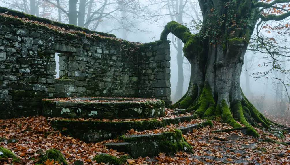
Today’s visitors to Monson will discover one of New England’s most significant archaeological treasures spanning over 17,000 acres, with a protected 200-acre historic park at its core.
You’ll find remarkable archaeological discoveries throughout the site’s 3-mile trail system, where archaeologists have meticulously uncovered colonial life’s physical remnants.
The site’s historical artifacts reveal fascinating insights into early colonial settlement:
- Stone foundations and cellar holes mark seven original homesteads, including the Gould and Wallingford families.
- Elaborate stone structures showcase sophisticated craftsmanship beyond typical pioneer capabilities.
- Excavated chimney bases and hearthstones provide glimpses into 18th-century domestic life.
- Carefully preserved ruins are labeled with biographical information about original settlers, including Thomas Nevins Jr., who raised eight children here.
Preservation Efforts and Modern Trails
The remarkable archaeological discoveries at Monson might’ve been lost forever if not for a watershed moment in 1998, when a proposed 28-lot luxury housing development galvanized local residents into action.
Through preservation strategies championed by the Society for the Protection of New Hampshire Forests, over 200 acres were permanently protected, with additional donations expanding the site further.
Today, you’ll find a well-maintained 3-mile network of modern trails connecting seven original colonial home sites. The trails wind through diverse landscapes, featuring interpretive signs that tell the stories of early settlers. Many visitors seek out Russ Dickerman, descendant of an original settler, for fascinating historical insights.
You can download the OuterSpatial mobile app to enhance your visit, providing detailed maps and historical information. The Gould House serves as an educational center, while strategically placed benches near the beaver wetland offer peaceful wildlife viewing opportunities.
Natural Wonders and Wildlife
While remnants of colonial history draw visitors to Monson, its natural wonders create an equally compelling attraction through a remarkable convergence of ecosystems.
You’ll find extensive wildlife observation opportunities centered around thriving beaver habitats, where active dams create diverse wetlands supporting herons, migratory birds, and aquatic species.
The area’s natural highlights include:
- A prominent heron rookery visible during early summer months
- Mountain laurel displays blooming each June across forest edges
- Extensive beaver wetlands supporting rich aquatic biodiversity
- Historic stone walls harboring unique microhabitats for native species
As you explore the mixed hardwood forests and open fields, you’ll encounter white-tailed deer, various songbirds, and small mammals.
The property’s varied terrain, from wetlands to upland forests, creates an intricate tapestry of habitats that change dramatically with New England’s seasons.
Colonial Legacy and Historical Impact
Beneath the natural splendor of Monson’s landscape lies a rich colonial history that shaped New Hampshire’s early development.
You’ll find the remnants of New Hampshire’s first inland colony, established in the 1730s, which faced numerous colonial challenges that ultimately led to its abandonment by 1770.
The settlement’s story reflects the broader struggles of early American colonization. Despite initially attracting about 15 families who purchased over 17,000 acres, Monson’s settlement sustainability proved difficult.
Without public buildings or proper infrastructure, the community struggled to maintain cohesion.
Today, you can explore this fascinating piece of colonial history through preserved cellar holes, stone walls, and a 3-mile trail system.
These archaeological remains serve as silent witnesses to the ambitious dreams and harsh realities of inland colonial expansion.
Frequently Asked Questions
Are There Any Documented Paranormal Activities or Ghost Sightings in Monson?
Ever wonder why some ghost towns lack spirits? You won’t find documented ghost stories or haunting experiences here – historical records and visitor accounts focus purely on colonial archaeology and natural preservation rather than paranormal activity.
This is particularly true in places like North Brother Island, which has a rich history of North Brother Island that showcases its use as a quarantine hospital. Its haunting structures and overgrown landscapes tell a different story, one rooted in public health and isolation. Visitors may leave feeling the weight of history rather than whispers of the past.
What Happened to the Original Furniture and Artifacts From Monson’s Houses?
You won’t find any original furniture preserved from Monson’s houses – the elements destroyed wooden artifacts over centuries, while departing families likely took valuable items when they left in the 1770s.
Did Native Americans Have Settlements in the Monson Area?
Like shadows in history’s mist, Native Americans didn’t establish permanent settlements at Monson itself, though you’ll find they seasonally hunted these rich forests as part of the broader Pennacook and Abenaki territories.
Can Visitors Conduct Metal Detecting or Artifact Collecting at the Site?
You shouldn’t conduct metal detecting or artifact collecting at this protected archaeological site – it’s likely prohibited and could damage important historical evidence. Stick to photography and exploring the marked trails instead.
Were There Any Notable Crimes or Conflicts During Monson’s Brief Existence?
You won’t find any documented Monson crimes or conflicts in historical records. While tensions with Native Americans and political instability were possible, there’s no concrete evidence of violent disputes during the settlement’s existence.
References
- https://thefrogandpenguinn.blogspot.com/2021/07/a-nh-ghost-town.html
- https://www.youtube.com/watch?v=LO__zPGtXiI
- https://www.nhmagazine.com/the-mystery-of-monson/
- https://brandyellen.com/the-monson-center-in-new-hampshire/
- https://www.forestsociety.org/property/monson-center
- https://www.atlasobscura.com/places/monson-new-hampshire
- https://www.forestsociety.org/forest-notes/forest-notes-digging-and-dating
- https://en.wikipedia.org/wiki/Monson
- https://www.youtube.com/watch?v=uDnkVXYq5iQ
- https://www.frontporchrepublic.com/2022/12/monson-maines-fascinating-story-a-review-of-here-everywhere-else/