You’ll find Monticello’s ghost town remnants in modern-day Shawnee, Kansas, where this once-promising frontier settlement emerged in 1857. Despite its strategic location and early success, including Wild Bill Hickok serving as township constable in 1858, the town faced devastating setbacks from tornadoes and fires. When the Atchison, Topeka and Santa Fe Railroad bypassed Monticello by two miles in 1869, the town’s fate was sealed. By 1910, only 63 residents remained, marking the beginning of this fascinating pioneer settlement’s transformation into Johnson County history.
Key Takeaways
- Monticello transformed from a promising frontier town established in 1857 to a ghost town after being bypassed by the railroad in 1869.
- The town’s population plummeted to just 63 residents by 1910, marking its decline from a once-thriving commercial center.
- Multiple natural disasters, including eight tornadoes and the devastating 1951 flood, contributed significantly to Monticello’s abandonment.
- The area was officially absorbed into the city of Shawnee in 2006, erasing the last administrative traces of historic Monticello.
- Nearly all physical remnants of original Monticello have vanished, with only historical markers remaining to document its pioneer heritage.
The Birth of a Frontier Settlement
While tensions over slavery gripped the Kansas Territory in 1857, a new settlement called Monticello emerged at a strategic crossroads 160 acres in size.
You’ll find it positioned where the Midland Trail met the military road connecting Fort Leavenworth to Fort Scott, making it an ideal stagecoach stop between Westport and Lawrence.
Despite pioneer hardships, the town’s settlement strategies proved sound. A town hotel and blacksmith shop helped establish Monticello as a thriving community by 1860.
Colonel A. Payne and W.J. McCarthy led the town company, naming it after Thomas Jefferson’s home to signal their Unionist sympathies. The town quickly established a post office in 1858.
By 1859, you could purchase town lots from $15 to $100.
The location’s appeal stemmed from its proximity to Mill Creek, where John Owens had staked his claim in 1840, and the former Shawnee lands that opened to settlers following territorial treaties.
Native Lands to Township Formation
You’ll find the Monticello area was originally home to the Shawnee and Kaw Nations until the 1825 treaties pushed them westward and established individual land allotments.
Frederick Chouteau established a pioneer trading post to facilitate commerce between settlers and Native Americans.
The first grist and sawmill operations built in 1836 served the relocated Shawnee community by producing essential flour and lumber.
The official formation of Monticello Township in 1857 marked the shift from Native territories to structured Euro-American governance over roughly 27,000 acres of Johnson County land.
Wild Bill Hickok’s 1858 election as township constable exemplified the rapid establishment of municipal systems on what had been Shawnee reservation lands just years before.
From Shawnee to Settlement
Before becoming a township in 1857, the land that would become Monticello was home to the Shawnee Indians, who’d moved to the area in the early 19th century after being displaced from their ancestral lands.
You’ll find that Shawnee culture flourished initially as they built log homes along wooded streams and hunted freely.
However, land treaties in 1825 forced them to relinquish territories in Ohio and Missouri for a Kansas reservation, drastically changing their way of life. The tribe established settlements along the Kansas River, becoming skilled traders and farmers.
- The Shawnee received 200-acre allotments per person under new government policies
- European settlement pressure led to the dissolution of communal reservations
- Some Shawnee integrated with white settlers, while others moved to Oklahoma
- Smallpox devastated the population when a band arrived from Ohio in 1830
- The area transformed into Monticello Township, named after Jefferson’s Virginia home
Early Township Governance Forms
As native lands shifted to organized settlements in 1855, Kansas Territory established a framework of counties and townships to manage the expanding frontier.
In Monticello Township, you’d find a robust system of local administration spanning 42 square miles of mixed prairie and timber lands along the Kaw River.
Township governance took shape through elected officials, with Wild Bill Hickok serving as constable in 1858.
The township hall became the center of civic life, where leaders managed essential services like roads, schools, and justice matters.
Colonel A. Payne’s town company organized property lots and guided economic development, including stores, a hotel, and a blacksmith.
These structures helped maintain order and services as settlers filed claims along Mill Creek and established homesteads throughout the territory.
Due to geographic limitations, certain township services were not accessible to settlers in remote areas of the territory.
The area’s original inhabitants, the Shawnee Indians, had established communities long before European settlement began.
Natural Disasters and Early Challenges
When you look at Monticello’s history, the devastating 1858 tornado stands out as a pivotal moment that nearly destroyed the entire frontier settlement.
You’ll find that just four years later, in 1862, the town suffered another significant setback when J.M. Reed’s prominent hotel burned to the ground.
These early disasters severely disrupted the town’s development, with impacts that would echo through subsequent decades until Monticello’s final dissolution. Like many frontier communities, the town was originally designed with a square plaza layout to defend against potential attacks.
Located in Johnson County, Monticello represents one of Kansas’ most well-documented ghost towns from the territorial period.
1858 Tornado’s Total Devastation
Throughout its history, Monticello, Kansas endured eight devastating tornadoes that repeatedly ravaged the town’s infrastructure and ultimately contributed to its decline.
You’ll find evidence of tornado destruction in the town’s historical records, showing how these violent storms defied terrain myths and wreaked havoc on the community’s spirit. Despite remarkable community resilience, the repeated battering proved too much for Monticello’s survival. NOAA’s detailed tracking of each tornado’s path through the region provided crucial documentation of the destruction.
- The 1974 Super Outbreak delivered one of the most violent blows, causing multiple fatalities near the Tippecanoe River.
- Farms northwest of town were completely leveled by EF3+ intensity storms.
- Schools, factories, and local businesses suffered extensive damage during multiple events.
- The National Guard frequently deployed to assist with cleanup and recovery efforts.
- Agricultural losses from repeated tornado strikes crippled the local farming economy.
The Great Hotel Fire
Despite the promise of modern amenities like fire escapes, Monticello’s hotels faced devastating fires that shaped the town’s early development.
You’ll find that J.M. Reed’s prominent hotel burned to the ground in 1862, during an era when hotel safety standards were practically nonexistent. The town’s firefighting capabilities were severely limited, with response times often stretching beyond 25 minutes due to reliance on neighboring townships.
Later, the three-story Monticello Hotel, built by John Riley in 1903, introduced the town’s first fire escapes.
While this improvement in fire prevention marked progress, the 26-room establishment struggled to attract guests despite its prime location across from the Baltimore & Ohio railroad station.
Today, the building’s original form is gone, transformed in the 1990s into an art studio.
Devastating 1951 Flood Impact
The catastrophic 1951 flood that swept through Kansas marked one of the most devastating natural disasters in the state’s history, inundating over 2 million acres across multiple river basins.
You’ll find that Monticello, situated near the Kansas River, faced severe flooding alongside 150 other communities. While specific details of Monticello’s flood recovery aren’t extensively documented, the community’s resilience was tested as water levels rose rapidly, forcing widespread evacuations.
- Floodwaters reached unprecedented levels, exceeding previous records by 4-6 feet
- Heavy rainfall from May to July dumped up to 400% of normal precipitation
- Economic losses ranged from $1-2.5 billion (1951 dollars)
- Over 45,000 homes were damaged or destroyed across the region
- Emergency water deliveries became necessary as 33 municipal water systems failed
Railroad’s Impact on Town Destiny
When rail planners charted the course of the Atchison, Topeka and Santa Fe railroad in 1869, their decision to bypass Monticello by two miles east sealed the town’s fate.
You can trace the town’s rapid economic decline directly to these railroad decisions, as commerce shifted to newly established rail-served communities like Holliday, Zarah, and Wilder.
What was once a thriving stagecoach stop at the crossroads of the Midland Trail and Territorial Road couldn’t compete without rail access.
Businesses relocated to rail-connected towns, and Monticello lost its county seat status to Olathe.
By 1910, the population had dwindled to just 63 residents.
The Kansas Midland Railroad’s similar choice to bypass Monticello further isolated the community, transforming it from a vibrant crossroads into a disappearing rural settlement.
Rise and Fall of Local Commerce
Monticello’s commercial promise emerged in 1857 as settlers established a strategic trading post at the intersection of the Midland Trail and the military road. You’d have found Rich & Rively’s store and J.M. Reed’s hotel serving travelers along these crucial routes.
After surviving the Civil War intact, the town’s fate turned when the Atchison, Topeka, and Santa Fe rail bypass of 1869 triggered severe commerce stagnation. Trade shifted to new rail-connected towns like Holliday and Wilder, leading to Monticello’s eventual abandonment.
- First store opened on 160 acres of prime crossroads location
- Early trade flourished from east-west and north-south traffic
- Local farmers supplied goods after Shawnee reservation dissolution
- Post-war economy remained primarily agricultural
- Railroad’s two-mile bypass proved fatal to town’s survival
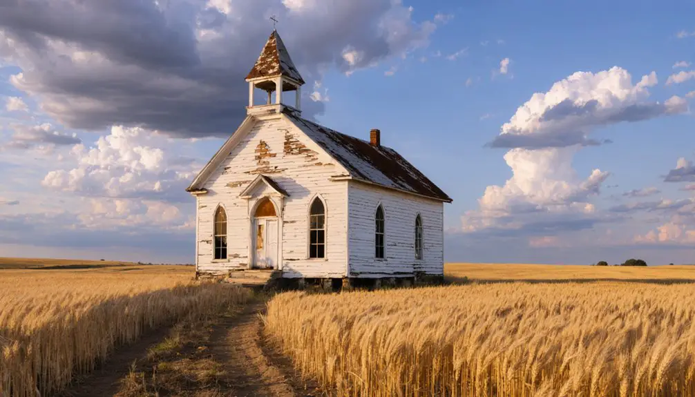
Churches and Community Gatherings
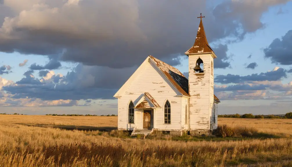
Despite its commercial decline, churches served as essential community anchors throughout Monticello’s history, with the Methodist Church at 75th and Gleason Road standing as the town’s most enduring institution.
You’d find a diverse array of Protestant denominations, including Clear Creek Baptist, Gospel Assembly, and a Colored Church in Holliday, fostering community resilience across ethnic and religious lines.
Church functions became increasingly significant after the post office’s closure in 1905, with religious venues hosting gatherings that strengthened social bonds.
During challenging times, particularly following the floods of 1894 and 1951, these churches provided critical support networks for rebuilding efforts.
Even as development pressures mounted in the mid-20th century, churches remained steadfast in preserving Monticello’s cultural heritage and community spirit.
Educational and Civic Development
As settlers established roots in Monticello in 1857, they quickly prioritized education by building the town’s first schoolhouse a mile west of the settlement.
You’d find educational priorities focused on basic literacy and practical knowledge, serving the agricultural community‘s needs.
The town’s civic engagement centered around a dedicated group of leaders, including Colonel A. Payne and W.J. McCarthy, who formed the original town company.
- Town meetings and public speeches in the square fostered local governance
- Early educators and community members shared teaching responsibilities
- The civic motto “Monticello and the Union” reflected community values
- Educational facilities remained modest due to limited resources
- By 1910, only the schoolhouse remained as one of few standing structures
Legacy in Modern Johnson County
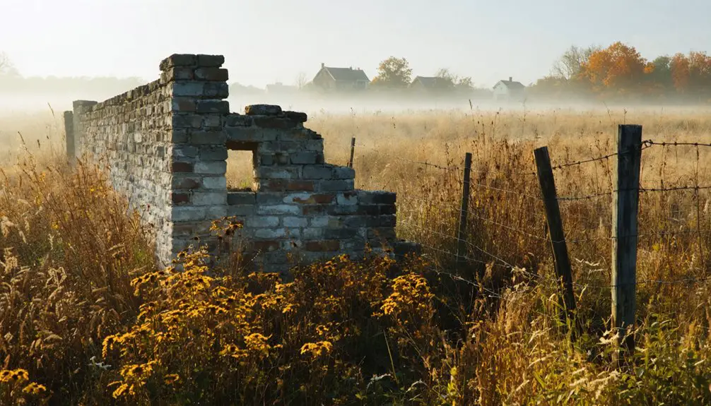
Today, you’ll find few traces of the original Monticello settlement within modern Johnson County’s suburban landscape. The township’s gradual absorption into Shawnee city, completed in 2006, marks a dramatic transformation from its agricultural roots.
As suburban sprawl consumes Johnson County’s landscape, Monticello’s rural past fades into memory, preserved only in historical records.
While cultural preservation efforts include historical markers documenting the area’s pioneer heritage, physical remnants of the once-thriving community have largely vanished beneath modern development.
The ghost town’s legacy lives on primarily through urban integration, as former township lands now host suburban neighborhoods and commercial zones along the Kansas River corridor.
The area’s evolution from Native American territory to pioneer settlement, then to abandoned townsite, and finally to suburban expanse reflects the broader story of Johnson County’s development – a reflection of the region’s continuous reinvention and growth.
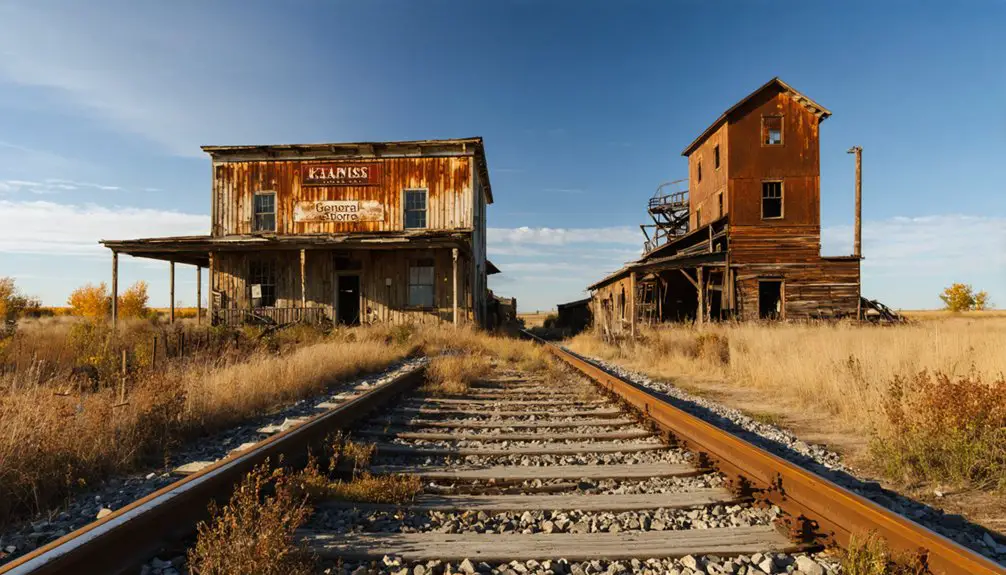
The Ghost Town’s Remaining Landmarks
While most of Monticello’s original structures have vanished, several significant landmarks still stand as tributes to this former Kansas settlement.
Through historic preservation efforts and community engagement, you’ll find remnants of this once-thriving town scattered across modern Johnson County. The rare wood-frame Monticello General Store at 7110 Brockway represents one of the area’s few surviving commercial structures from 1870, while the rebuilt Monticello Methodist Church continues to anchor the intersection of 75th and Gleason Road.
- Visit the Monticello Community Historical Society Museum at 23860 W 83rd Street to explore artifacts and exhibits
- Explore the Virginia School House for insights into early rural education
- Pay respects at Union Cemetery, where early settlers rest
- Marvel at the National Folk style architecture of the General Store
- Experience five different historic religious sites that once served the community
Frequently Asked Questions
What Was the Average Population of Monticello During Its Peak Years?
You’ll find intriguing population trends showing historical demographics peaked at approximately 1,100 residents during the 1870s, though this number represented the broader township rather than just the town proper.
Were There Any Famous Residents or Visitors to Monticello?
You won’t find any famous visitors or nationally notable residents in Monticello’s history. The town’s significant figures were local pioneers like John Owens, Colonel A. Payne, and merchant partners Rich & Rively.
What Types of Businesses Operated in Monticello Before Its Decline?
Like a pioneer’s survival kit, you’d find everything from Rich & Rively’s general store to Solomon Coker’s merchandise shop, a bustling blacksmith shop, saloons, stagecoach hotel, and land office serving travelers.
How Much Did Land Cost in Monticello During Its Early Settlement?
You’d have found land prices remarkably low as early settlers could claim 320-acre homesteads for minimal fees under federal land policies, though costs increased when water rights and improvements were added.
Did Any Archaeological Artifacts Remain From the Original Shawnee Inhabitants?
While historical records confirm Shawnee presence, you won’t find documented archaeological artifacts from original Shawnee inhabitants at Monticello. Early excavations weren’t focused on preserving Native American items or recording their significance.
References
- https://www.jocohistory.org/digital/custom/monticello
- https://legendsofkansas.com/monticello-kansas/
- https://jocohistory.wordpress.com/2019/01/13/monticello-area-history/
- https://metrovoicenews.com/ghost-towns-of-kansas-city/
- https://monticelloks.org/history.htm
- https://legendsofkansas.com/shawnee-kansas/
- https://en.wikipedia.org/wiki/History_of_the_Kansas_City_metropolitan_area
- http://www.twinmillfarm.com/history.html
- https://www.jocogov.org/newsroom/exploring-native-american-history-johnson-county
- http://www.greenviewridge.org/info.php?pnum=25b593ca5b8775


