You’ll find the remnants of Fort Mansfield’s coastal defense system at Napatree Point, where military installations once protected Rhode Island’s shores in the early 1900s. After revealing a critical defensive flaw during war games, the fort was abandoned by 1917, and its guns were removed. The devastating 1938 hurricane later submerged Battery Connell and destroyed 39 nearby cottages, leaving behind a ghost town that now serves as a wildlife sanctuary. The hidden ruins beneath shifting sands tell fascinating stories of military strategy and natural disaster.
Key Takeaways
- Napatree Point became a ghost town after the devastating 1938 hurricane destroyed 39 coastal cottages and wiped out the local community.
- Fort Mansfield’s abandoned military ruins, including submerged Battery Connell, contribute to the area’s ghost town status.
- Former foundations of boarding houses and hotels lie beneath Napatree Point’s shifting sands, hidden by coastal erosion.
- The area transformed from a bustling military installation and vacation community into a protected wildlife sanctuary.
- Historic ruins from multiple time periods, including Native American lookouts and colonial beacons, remain scattered throughout Napatree Point.
The Native American Legacy of Napatree Point
Centuries before European settlement, the Narragansett Indians maintained a sophisticated presence around Napatree Point and the surrounding Watch Hill area.
You’ll find their legacy deeply woven into the region’s indigenous storytelling, as they strategically used Watch Hill’s elevated terrain to monitor Long Island Sound and nearby waters for potential threats.
The Narragansett’s intimate knowledge of the landscape helped shape early European understanding of the area.
Today, their ancestral lands support diverse wildlife, including mussel beds, bats, minks, foxes, and numerous bird species.
When Dutch explorer Adriaen Block arrived in 1614, he noted the dense forest cover that gave Napatree its name – likely influenced by Native American geographic knowledge.
Through cultural preservation efforts, we’ve learned how the Narragansett’s coastal surveillance system demonstrated their advanced understanding of maritime defense, establishing a foundation for later colonial warning systems.
This pristine coastal area would later become home to Fort Mansfield in 1898, marking a continuation of the location’s strategic military importance.
From Colonial Beacons to Military Fort
When colonial settlers recognized the strategic importance of Rhode Island’s coastline, they established an innovative network of seven warning beacons stretching from Watch Hill to Providence.
These tall poles with pitch buckets formed an essential colonial defense system, allowing rapid beacon communication through fire and smoke signals visible across long distances.
– Watch Hill’s commanding views of Block Island, Montauk Point, and Fishers Island made it a critical observation post.
In 1745, the first watch house was constructed to enhance coastal surveillance during the French and Indian War.
The area was named for the abundant woodlands that once covered the point, earning it the name Nape of Trees.
- Napatree Point’s strategic location guarded Little Narragansett Bay’s entrance, continuing traditions established by Native Americans.
- The Great Gale of 1815 transformed Napatree from a forested “Nap of Trees” into a deforested landscape.
- By 1898, you’d find Fort Mansfield rising on Napatree’s western tip, housing three artillery batteries and 100 soldiers before its flawed design led to early decommissioning in 1907.
The Rise and Fall of Fort Mansfield
At the dawn of the twentieth century, Fort Mansfield emerged as a crucial coastal defense installation on Rhode Island’s Napatree Point. The U.S. Army’s impressive military architecture included two 8-inch rifles on disappearing carriages and two 5-inch rapid-fire guns, designed to protect Watch Hill and Long Island Sound’s approaches. Named after General Joseph K. Mansfield, the fort was part of a vast network of coastal fortifications.
You’d think such fortifications would prove impenetrable, but war games in 1907 exposed a fatal flaw. Enemy ships could exploit a “dead angle” along the coast, safely positioning themselves beyond the fort’s gun range.
This revelation led to the fort’s swift decline – by 1909, it was demoted to training status. The guns were removed by 1917, and the garrison dwindled to just six men. Today, visitors must trek through thick beach vegetation to reach the abandoned fortress ruins.
When the military finally sold the property in 1928, Fort Mansfield’s brief chapter in coastal defense had ended.
Hidden Ruins in a Coastal Paradise
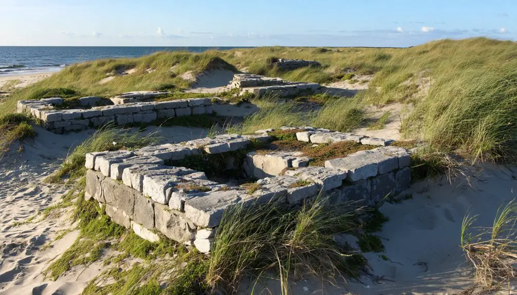
Deep beneath the dense vegetation of Napatree Point lies a treasure trove of hidden ruins spanning multiple centuries of coastal history. As you explore this coastal paradise, you’ll discover remnants of colonial beacons, military installations, and long-lost summer cottages, each telling a story of human ambition versus nature’s power.
The devastating 1938 hurricane transformed the landscape forever, claiming 15 lives and severing Sandy Point from the mainland.
- Ancient Native American lookout points still offer strategic vantage points for coastal exploration.
- Fort Mansfield’s ghostly ruins peek through thick shrubs, concealing 18 former military buildings.
- Colonial-era beacon remains reveal historical warning systems using smoke and fire.
- Hidden foundations of destroyed boarding houses and hotels lie scattered beneath shifting sands.
The ruins you’ll find are constantly transformed by nature’s forces, with storm-driven ecosystems and coastal erosion regularly exposing new hidden treasures while burying others beneath layers of sand and vegetation.
Wildlife Sanctuary and Natural Preservation
Beyond the historic remnants that dot the landscape, Napatree Point stands as an essential wildlife sanctuary managed jointly by the Watch Hill Conservancy and Watch Hill Fire District.
You’ll discover remarkable wildlife diversity here, from nesting piping plovers to majestic ospreys and American oystercatchers. The sanctuary’s significant role in habitat restoration has made it one of the East Coast’s most important migratory bird stopover sites. The area’s 86-acre peninsula provides diverse habitats within its 1.5-mile stretch. Visitors can enjoy long sweeping views across Little Narragansett Bay while exploring the sanctuary.
If you’re planning to explore, you’ll need to follow specific guidelines that protect these delicate ecosystems. Dogs aren’t allowed during peak seasons from May through Labor Day, and you’ll want to stick to designated paths.
While you can’t access every area, you’ll find plenty of opportunities to observe the rich coastal environment, from ocean-facing beaches to peaceful bay-side marsh trails.
Strategic Significance Through Time
Though often overlooked today, Napatree Point has played an essential strategic role throughout history, starting with the Narragansett Indians who used it as a significant lookout point over Long Island Sound and Fishers Island Sound.
You’ll find this peninsula’s importance woven through centuries of coastal defense and historical navigation, from colonial beacon stations to Fort Mansfield‘s artillery installations. The natural elevation and “Nap of Trees” landscape made it perfect for monitoring maritime traffic and defending against potential threats.
- Served as a critical node in colonial America’s seven-station warning system from Watch Hill to Providence
- Became home to Fort Mansfield in 1898, protecting Little Narragansett Bay with three large cannon batteries
- Offered unmatched views of Block Island, Rhode Island coast, Montauk Point, and surrounding waters
- Formed part of an integrated northeastern seaboard defense network during the early 20th century
A Ghost Town’s Cultural Impact Today
While Napatree Point’s strategic military significance has faded into history, its cultural impact continues to resonate powerfully today.
You’ll discover a rich tapestry of cultural resilience through the Watch Hill Conservancy’s preservation efforts, which blend environmental protection with historical storytelling. The dramatic tale of 39 cottages lost to the 1938 hurricane lives on through community storytelling, shaping local identity and connecting visitors to themes of survival and renewal. The same hurricane caused Battery Connell to be completely submerged, adding another layer to the area’s historical narrative.
Artists and writers draw inspiration from Fort Mansfield’s ruins and the ghost town’s haunting beauty, creating works that explore abandonment and nature’s reclamation.
The crumbling remains of Fort Mansfield stand as a haunting muse, whispering stories of desertion to artists seeking nature’s triumph.
Through guided tours, educational programs, and interpretive trails, you’ll experience a unique convergence of military history, ecological recovery, and cultural heritage that defines Napatree Point’s enduring legacy in New England’s coastal narrative.
Frequently Asked Questions
Can Visitors Access the Fort Ruins at Night or During Winter Months?
You’ll find no official restrictions on night access or winter visits to the fort ruins, but natural conditions and safety concerns make exploring during those times challenging and potentially dangerous.
Are Metal Detectors or Archaeological Exploration Permitted at Napatree Point?
Like a closed treasure chest, you won’t be able to metal detect here. Metal detecting regulations prohibit recreational searching, and you’ll need special archaeological permits that aren’t issued for personal exploration.
What Safety Precautions Should Visitors Take When Exploring the Concrete Ruins?
Wear proper safety gear like sturdy shoes and gloves when exploring concrete ruins. Bring a first aid kit, stay with a buddy, and don’t climb unstable structures or ignore warning signs.
Has Paranormal Activity Ever Been Reported Around the Abandoned Fort Structures?
With over 200 police reports at Fort Wetherill, you’ll find documented ghost sightings nearby. However, at Fort Mansfield itself, paranormal investigations haven’t produced concrete evidence, though local legends persist about haunted corridors.
Just a short distance away, the Feltville Historic District history adds to the area’s eerie allure, with tales of the early settlers and their mysterious disappearances. Many visitors claim to experience an unsettling presence as they stroll through the deserted streets and dilapidated structures. This blend of historical significance and ghostly folklore draws both history buffs and thrill-seekers alike.
How Close Can Boats Anchor to Napatree Point’s Shoreline?
You’ll need to follow strict boating regulations and anchoring guidelines, using only designated mooring buoys offshore rather than anchoring near the shoreline. Check current CRMC restrictions before planning your approach.
References
- https://seewesterly.com/a-fatal-flaw-a-history-of-fort-mansfield-on-napatree-point/
- https://abandonedwonders.com/2015/03/19/fortress-of-solitude-journey-to-the-lost-fort-of-rhode-island/
- https://freepages.history.rootsweb.com/~gtusa/usa/ri/ft-man.htm
- https://abandonedwonders.com/tag/napatree-point/
- https://www.youtube.com/watch?v=rvYe_OIvia0
- https://thewatchhillconservancy.org/napatree/history-of-napatree/
- https://ecori.org/2021-3-19-left-undeveloped-for-eight-decades-napatree-point-roles-with-the-tide-and-shifts-with-the-sands/
- https://landtrustalliance.org/resources/learn/explore/building-knowledge-to-respond-to-change
- https://thewatchhillconservancy.org/wp4/wp-content/uploads/2019/04/Consevator-14Feb.pdf
- https://en.wikipedia.org/wiki/Napatree_Point