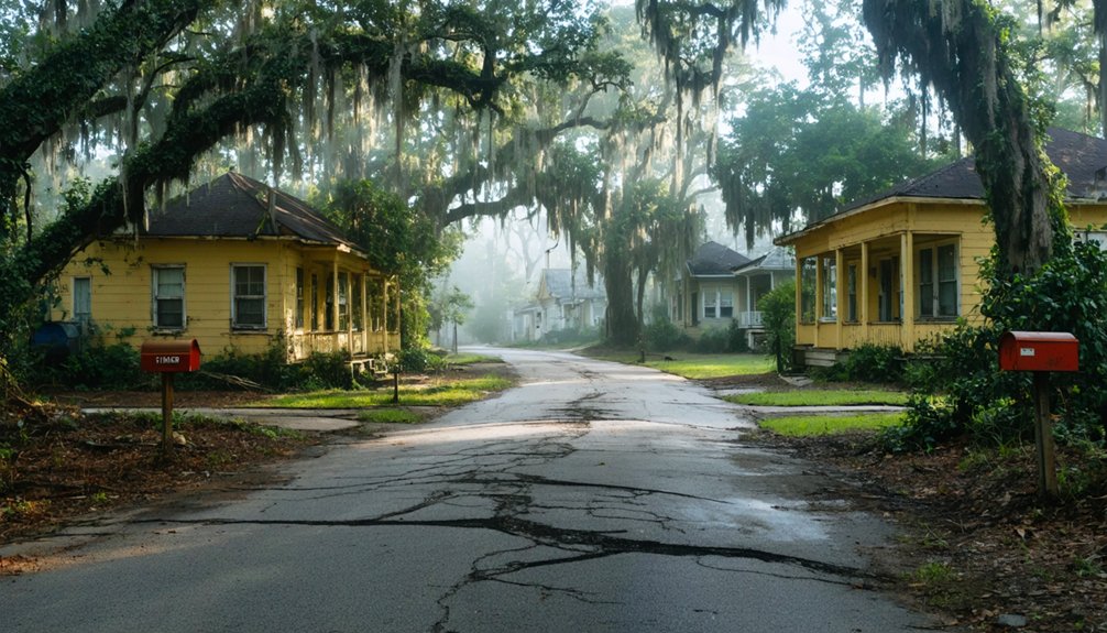
When exploring abandoned southern suburbs, you’ll need to identify zombie foreclosures through satellite imagery showing overgrown vegetation and rust-colored rooftops. Always establish emergency plans with a contact, map multiple exit routes, and carry doorstops to prevent accidental lock-ins. Document your exploration with mirrorless cameras for low-light conditions and maintain offline GPS maps as backup. Southern states like Florida, with a 3.25% zombie foreclosure rate, offer unique documentation opportunities amid their spectral landscapes.
Key Takeaways
- Use satellite imagery and AI-powered platforms to identify abandoned properties through signs like overgrown vegetation and structural decay.
- Establish emergency plans with exit routes mapped beforehand and carry safety equipment including doorstops to prevent accidental lock-ins.
- Document exploration safely with appropriate cameras, protective gear, and offline GPS maps for areas with poor signal.
- Recognize neighborhood deterioration indicators such as physical decay, decreased community engagement, and evidence of illicit activities.
- Research property history for hazards like asbestos and monitor foreclosure listings and tax delinquency records to identify high-risk abandoned areas.
Understanding Zombie Foreclosures in the Southern Housing Market
Thousands of seemingly abandoned homes haunt the southern suburbs, their empty windows staring blankly at passersby while their legal status remains in limbo.
You’re witnessing zombie title dynamics in action—where homeowners flee after receiving foreclosure notices, not realizing they still legally own these properties. The South, particularly Florida, leads the nation in this phenomenon with a 3.25% zombie foreclosure rate. These vacant homes often create safety issues that concern neighboring residents and local authorities alike.
Abandoned by owners but not by law, these zombie properties haunt communities with their spectral legal status.
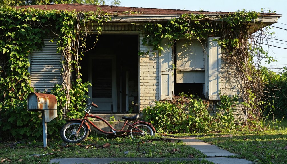
When lenders abandon foreclosure proceedings midway, you’re left maneuvering through a dangerous legal wilderness. These properties typically suffer from lack of maintenance which contributes to their deteriorating condition and further neighborhood decline.
The economic impacts ripple through communities like invisible shockwaves. Your neighborhood’s property values plummet while crime rates climb.
Meanwhile, unsuspecting former homeowners remain shackled to tax obligations and mounting code violations. In this high-stakes game, understanding the distinction between foreclosure notice and completed process might save you from joining the ranks of zombie title holders.
Identifying High-Risk Abandoned Areas Before Your Visit
You’ll uncover hidden danger zones by examining satellite images that reveal tell-tale signs of abandonment like overgrown vegetation and boarded windows before you step foot in a neighborhood.
Track local foreclosure listings and tax delinquency records to pinpoint properties caught in financial limbo, where zombie foreclosures create perfect conditions for squatters and criminal activity.
Watch for clusters of physical deterioration indicators—graffiti-covered walls, broken streetlights, and accumulating trash—which signal areas where community oversight has collapsed and safety risks have multiplied.
Communities with high unemployment rates often experience increased property abandonment as residents migrate elsewhere seeking better economic opportunities.
Satellite Imagery Tells All
While urban explorers once relied solely on whispered rumors and faded maps, today’s technology offers a far more sophisticated approach to finding abandoned treasures in the South’s forgotten suburbs.
Satellite analysis and AI advancements have revolutionized how you can scout locations before risking a visit.
Through satellite imagery, you’ll spot telltale signs that signal promising exploration sites:
- Rust-colored or discolored rooftops – AI can detect these subtle hues indicating long-term vacancy
- Overgrown vegetation encroaching on structures – Nature reclaiming human territory
- Structural collapse or debris – Visible even from space
- Clustering of multiple abandoned properties – Higher risk, higher reward zones
Companies like Where Inc. have demonstrated remarkable success in developing AI systems that analyze satellite imagery to identify neglected properties with incredible accuracy.
This technology, which was originally designed to study lunar craters, has now been brilliantly adapted for identifying abandoned properties on Earth.
You’re now equipped to identify danger zones and untapped opportunities without setting foot on property—giving you freedom to plan bolder adventures with calculated precision.
Track Local Foreclosure Data
Beyond satellite views lies another treasure trove for the serious explorer: foreclosure data.
You’ll want to tap into platforms like Foreclosure.com and ATTOM Data Solutions for real-time tracking of distressed properties in your target zone.
Hunt for the earliest warning signs—Notices of Default and Lis Pendens filings give you a 30-45 day head start before properties officially enter foreclosure.
For maximum data accuracy, cross-reference county clerk websites with PropertyReach’s automated alerts that highlight financial distress indicators.
The most valuable intelligence comes from combining foreclosure tracking with tax liens and HOA foreclosures. Enhanced datasets can increase your chances of finding profitable opportunities by up to 35% compared to relying on public listings alone.
Look for seasonal patterns in historical datasets, especially post-holiday spikes.
The savviest explorers use AI-driven dashboards to identify foreclosure hotspots before they become obvious abandoned zones, giving you first access to territories others haven’t discovered.
Many smart investors review recording dates on foreclosure notices to establish timelines for potential property abandonment.
Neighborhood Deterioration Indicators
Successful exploration of abandoned southern suburbs hinges on your ability to spot neighborhood deterioration before it’s obvious to casual observers.
The skilled urban explorer recognizes subtle patterns of decline that most miss, giving you the freedom to assess risk before venturing deeper.
Look for these critical indicators when scouting potential exploration zones:
- Physical decay clusters – Multiple boarded-up buildings, overgrown lots, and accumulated debris within a concentrated area
- Decreased community engagement – Absence of residents outdoors, minimal interpersonal interaction, abandoned community spaces
- Neglected property maintenance – Systematic neglect beyond normal wear, including repeated code violations and utility disconnections
- Crime opportunity structures – Evidence of illicit activities, unusual foot traffic patterns, and makeshift entrances to vacant structures
These signs collectively reveal neighborhoods where abandonment has fundamentally altered the social landscape. Areas with high vacancy rates typically experience a 9.9% increase in fire risks, adding another hazard explorers should be vigilant about. Research shows that Black-majority neighborhoods experience more severe abandonment due to systemic racism and economic disinvestment.
Essential Safety Precautions for Exploring Vacant Suburbs
Before setting foot in abandoned southern suburbs, you’ll need to arm yourself with essential safety knowledge that could mean the difference between an exhilarating exploration and a trip to the emergency room.
Your safety gear checklist should include sturdy boots with ankle support, gloves for handling debris, an FFP3 mask for mold protection, and a reliable headlamp for dark corners.
Never venture alone—bring a trusted companion and establish emergency plans with someone who knows your location and expected return time.
Research the property’s history to anticipate hazards like asbestos insulation and rotting floors.
Map your exit routes before entering and carry doorstops to prevent accidental lock-ins.
Be mindful that you may encounter items containing lead paint dust, which can cause serious health problems when disturbed or inhaled.
The thrill of discovery awaits, but only for those who prepare properly.

Winding through the crumbling asphalt arteries of abandoned southern suburbs requires both tactical awareness and a spirited sense of adventure.
You’ll encounter deteriorated pathways where nature reclaims what humans abandoned, creating a labyrinth of infrastructure challenges that test your navigation skills.
To successfully traverse these forgotten landscapes:
- Rely on satellite imagery combined with GPS to identify passable routes—outdated maps won’t show collapsed bridges or blocked streets.
- Watch for overgrown vegetation concealing sudden drops or unstable pavement.
- Identify neighborhood patterns—industrial grids differ from residential layouts, affecting your route options.
- Look for informal markers left by previous explorers—painted symbols often indicate safe passages through particularly challenging areas.
Mastering these techniques transforms seemingly impassable terrain into your personal urban wilderness playground.
Documentation Tools and Legal Considerations for Urban Explorers
Capturing the decay and forgotten stories of these suburban ruins demands the right documentation arsenal and a sharp awareness of where exploration crosses into legal territory.
Arm yourself with a mirrorless camera for those haunting low-light shots and a lightweight tripod to stabilize images in crumbling interiors. Your smartphone serves as backup, but won’t deliver that gritty aesthetic urban exploration thrives on.
Always maintain documentation ethics by carrying proper protective gear—respirators for asbestos-filled buildings and sturdy boots for tetanus-laden floors.
Navigate with offline GPS maps and paper backups when signals fail in concrete labyrinths.
Resources for Tracking Southern Suburban Vacancy Trends
You’ll gain essential intelligence for your abandoned suburb explorations by utilizing specialized tracking resources like the U.S. Census Bureau’s quarterly vacancy reports, which reveal the South’s elevated 9.0% rental vacancy rate.
County-level foreclosure databases and MoveBuddha’s migration analyses can pinpoint neighborhoods with accelerating abandonment patterns, distinguishing between thriving job-magnet suburbs and those falling into neglect.
Interactive neighborhood mapping tools overlay vacancy data with economic indicators, allowing you to spot emerging ghost suburbs before mainstream explorers discover them.
As urban areas evolve, exploring ghost towns in Alabama can reveal fascinating stories of the past and hidden opportunities for revitalization. These areas often hold remnants of rich histories that can inspire new developments or community projects. By understanding the patterns of abandonment and potential future growth, you can gain insights into how these communities might be shaped in the years to come.
Online Vacancy Trackers
As suburban decay sweeps across the South’s once-thriving neighborhoods, digital tracking tools have emerged as essential navigational aids for urban explorers and researchers alike.
You’ll find powerful platforms featuring interactive geographic data that pinpoint exact vacancy hotspots down to specific census tracts and ZIP codes.
When venturing into the digital wilderness of abandoned property tracking, arm yourself with:
- GIS-integrated vacancy maps that reveal temporal patterns across southern suburbs
- Government portals offering downloadable datasets on tax delinquency and foreclosures
- Real-time trackers that correlate job market shifts with housing abandonment
- Mobile-ready platforms allowing on-site vacancy status updates during your explorations
These digital compasses will guide your journey through the fascinating landscape of southern suburban decline, revealing hidden patterns invisible to the untrained eye.
County-Level Foreclosure Reports
Moving beyond digital tracking tools, county-level foreclosure reports offer the most granular view into the skeletal remains of southern suburban communities.
You’ll uncover treasure troves of data at Sheriff’s Offices across Iowa counties, where properties in flux are meticulously documented.
Dive into Pottawattamie County‘s notices at courthouses and libraries, or navigate Scott County’s searchable online database.
Linn County provides historical context with records dating back to 2013—perfect for spotting foreclosure trends over time.
The real adventure begins when deciphering county documentation: opening bid amounts reveal true property values, while sale dates expose processing patterns.
Cross-reference these with state-level repositories organizing data by region.
Before bidding, conduct thorough due diligence through title searches and tax assessments—the Sheriff won’t guarantee clear titles on these frontier properties.
Neighborhood Mapping Tools
To effectively trace the ghost patterns of southern suburban decline, sophisticated neighborhood mapping tools have become the modern explorer’s compass and sextant. Venture into this technological frontier armed with platforms that reveal neighborhood demographics through layers of data.
- Immerse yourself in QGIS’s open-source wilderness, where multi-layer mapping discloses the hidden stories of abandonment without costing a dime.
- Scale the cloud heights with ArcGIS Online, collaborating with fellow urban adventurers in real-time.
- Conquer complex terrain using UrbanFootprint’s analytics to predict vacancy flows and policy impacts.
- Chart unmapped territories with remote sensing tools like ERDAS, tracking vacancy patterns from satellite vantage points.
These mapping technologies transform abstract data into visual narratives, guiding your expedition through forgotten suburban landscapes.
Frequently Asked Questions
How Long Do Zombie Foreclosures Typically Remain Vacant?
Like forgotten ships in a bureaucratic Bermuda Triangle, you’ll find zombie foreclosures timeline stretching for months to years—sometimes exceeding typical foreclosure periods—while property maintenance issues multiply and your financial obligations persist despite abandonment.
Can I Purchase Abandoned Properties Directly From Banks?
You can purchase bank-owned properties directly through REO departments. Immerse yourself in their listings, bypass property auctions, and negotiate deals others miss. Freedom awaits in these untapped real estate opportunities!
Are There Seasonal Considerations for Exploring Abandoned Southern Suburbs?
Like steering a wild pendulum, you’ll need to time explorations around seasonal weather patterns—avoiding summer’s oppressive heat, hurricane season’s dangers, and winter’s ice storms. Wildlife activity peaks during spring and fall migrations.
What Emergency Services Remain Available in Highly Abandoned Areas?
You’ll find limited emergency response: distant ambulances with delayed arrival times, fire stations serving multiple roles, and emergency shelters during disasters. Always establish your own safety protocols before venturing into these forgotten territories.
How Do Local Residents Typically React to Photographers or Explorers?
Curiosity killed the cat, but transparency revives it. You’ll encounter varied local sentiments—from protective wariness to genuine interest. Navigate this by fostering community engagement through respectful interactions rather than sneaking around.
References
- https://www.attomdata.com/news/market-trends/figuresfriday/top-10-counties-with-the-highest-zombie-foreclosure-rates-in-q2-2025/
- https://schoolofcities.utoronto.ca/neighbourhood-abandonment-in-the-american-rust-belt/
- https://mrpexplores.substack.com/p/east-st-louis-illinois-more-abandoned
- https://www.youtube.com/watch?v=hS27BhfMojc
- https://www.attomdata.com/news/most-recent/q1-2025-vacant-property-and-zombie-foreclosure-report/
- https://www.worldpropertyjournal.com/real-estate-news/united-states/irvine/real-estate-news-2025-home-foreclosure-data-attom-zombie-home-foreclosure-report-rob-barber-abandoned-foreclosure-properties-data-14533.php
- https://www.realtor.com/news/trends/zombie-foreclosures-are-up-see-which-states-are-hardest-hit/
- https://themortgagepoint.com/2025/05/30/vacant-property-rate-holds-steady-in-q2/
- https://www.fingerlakes1.com/2025/04/28/zombie-foreclosures-rise-2025-states-hit-hardest/
- https://journalrecord.com/2023/08/29/study-finds-1-in-79-homes-vacant-zombie-houses-on-rise/