You’ll find New Hampshire’s ghost towns hidden in plain sight—not dramatic Western mining camps, but subtle erasures where stone walls snake through forest and cellar holes collect autumn leaves. Monson, the state’s first inland colony from 1746, now exists as overgrown homestead foundations within a 200-acre historic park. Livermore thrived as a lumber town supporting 200 residents before the 1927 flood destroyed its railroad, leading to dissolution in 1951. Hill Village relocated fourteen buildings to escape Franklin Falls Dam’s reservoir, while East Lempster’s population plummeted from 941 to 391 between 1840-1900. Each settlement tells a distinct story of abandonment worth exploring further.
Key Takeaways
- Monson, New Hampshire’s first inland colony from 1746, is now a 200-acre historic park with trails through abandoned homesteads.
- Hill Village relocated fourteen buildings to escape Franklin Falls Dam construction between 1937-1940, preserving community over dissolution.
- Livermore thrived as a logging town from 1876 until the 1927 flood destroyed infrastructure; New Hampshire revoked incorporation in 1951.
- East Lempster’s population plummeted 58.5% from 1840-1900 due to agricultural decline, leaving only preserved historic buildings behind.
- Rindge’s industrial prosperity collapsed after railroad speculation, a 1916 fire, 1928 tornado, and highway rerouting ended its economic vitality.
Monson: A Settlement Reclaimed by the Wilderness
Deep in the borderlands between modern-day Hollis and Milford lies what remains of New Hampshire’s first inland colony—a settlement that flourished briefly before vanishing into memory. You’ll find Monson, incorporated in 1746, where harsh conditions and endless disputes over a meeting house location drove settlers away before the American Revolution.
Today, community preservation efforts have transformed these 200 acres into a remarkable historic park. The Society for Protection of New Hampshire Forests rescued the land from developers in 1998, creating trails through overgrown cellar holes and crumbling stone walls. Each homestead bears signs detailing its history.
You can explore the restored Gould House colonial museum, then hike to labeled ruins. Come mid-June for seasonal tourism when mountain laurel blooms spectacularly throughout the forest.
Hill Village and the Path to Franklin Falls Dam
Where the Pemigewasset River carved through Merrimack County‘s low-lying valleys, the settlement of New Chester took root in 1753—thirty thousand acres purchased by speculators from Chester who envisioned prosperity in the fertile bottomlands.
Renamed Hill in the 1830s after Governor Isaac Hill, this community faced unique infrastructure challenges as the Pemigewasset flooded annually, leaving dead branches thirty feet high in the trees.
When the Army Corps proposed Franklin Falls Dam in 1937, citizens chose collective survival over dissolution. Community relocation efforts between 1937 and 1940 moved fourteen buildings using railroad winches and horses to higher ground.
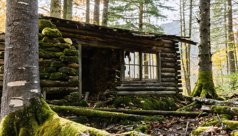
Livermore’s Rise and Fall as a Logging Community
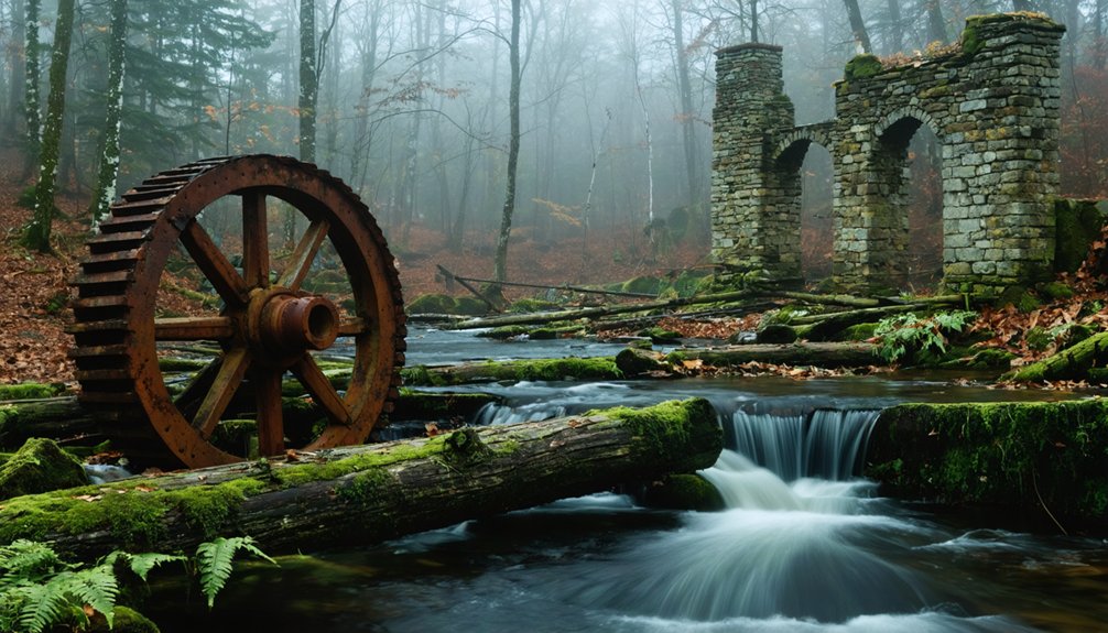
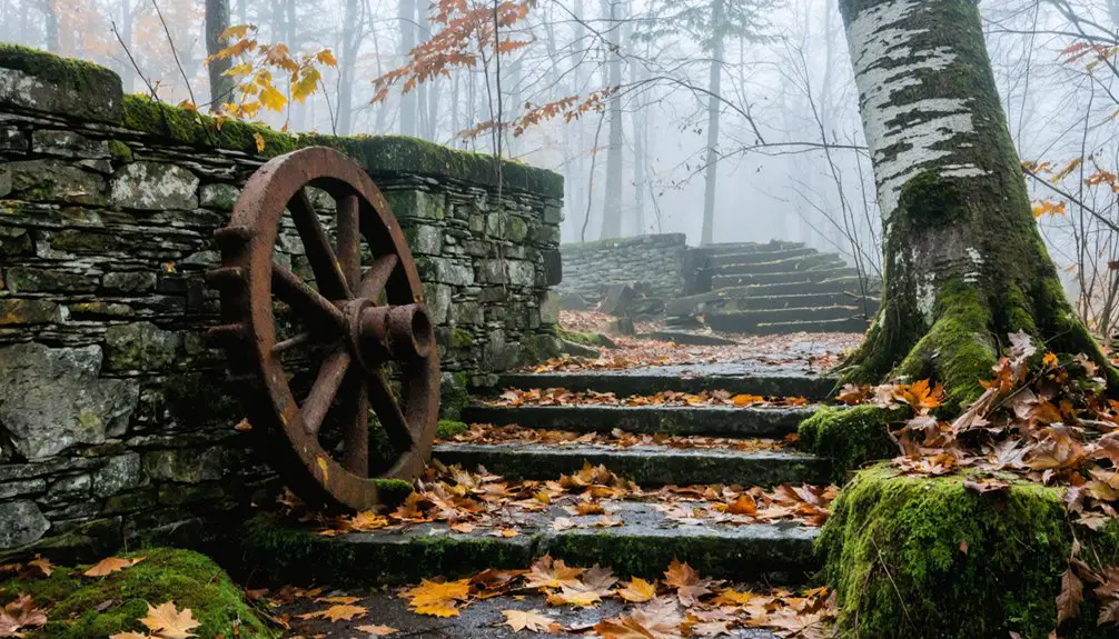
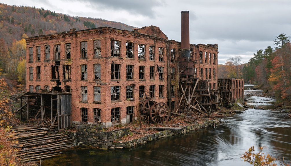
When the New Hampshire Legislature incorporated the Grafton County Lumber Company in 1874, the Saunders family had already spent a decade laying groundwork for what would become one of the White Mountains‘ most ambitious timber operations. Their $150,000 investment ($3.6 million today) transformed wilderness into Livermore village by 1876, complete with mills, housing, and infrastructure supporting 150-200 residents at peak.
Their practiced selective cutting—targeting specific spruce and fir sizes—minimizing environmental impact while generating $44,000 annually in lumber sales. Yet demographic shifts proved fatal: Charles Saunders’ death left inexperienced leadership, depleted timber reserves strained operations, and the catastrophic 1927 flood destroyed the Sawyer River Railroad. By 1928, mills sat silent. The Forest Service purchased most land in 1934, and New Hampshire revoked incorporation in 1951.
The Vanished Milltown of East Lempster
Unlike Livermore’s dramatic collapse under flood waters and depleted forests, East Lempster’s disappearance unfolded as a slow fade—the kind of death where you can’t pinpoint the exact moment the town stopped being a town. Agricultural decline and population loss gutted this Sullivan County settlement between 1840 and 1900:
- 1840-1860: Population dropped from 941 to 820 as farms failed
- 1870: A brutal 17.3% decline left just 678 residents
- 1900: Only 391 souls remained—a 24.7% plunge from previous decades
You’ll find architectural preservation efforts have saved fragments: the 1794 Meetinghouse, History Hall’s museum, that one-room schoolhouse on Dodge Hollow Road. The Lempster Historical Society operates without tax dollars, funded purely by voluntary support—preserving what remains of a community that simply bled out.
Ringe and the Collapse of Industrial Promise
You’ll find Rindge’s industrial ambitions documented in the Historical Society’s collection of 18th-century artifacts and maps, physical evidence of a town that never fulfilled its economic promise. The soldiers compensated with depreciated paper money from the 1690 Phipps expedition received land grants in 1736, establishing a settlement pattern driven by financial desperation rather than strategic planning.
Industrial Rise and Fall
As you trace Rindge’s evolution from wilderness grant to industrial center, the transformation becomes evident in the town records housed at the New Hampshire Historical Society. From Captain Abel Platts’ temporary 1738 settlement through permanent establishment in 1752, you’ll discover how water powered operations shaped prosperity.
By 1859, thirteen sawmills and thirteen shingle mills lined the waterways, supported by:
- Gristmills processing locally-grown grain demonstrating agricultural diversification
- Specialized facilities including Hopkinson’s Mill, Bobbins’ Mill, and Tarbell Mill producing spools
- Tanneries with shoe manufacture creating integrated production chains
The 1,274 residents enjoyed self-sufficiency until the $300,000 speculative Monadnock Railroad, 1916 station fire, and devastating 1928 tornado shattered this independent prosperity. Route 202’s reroute delivered the final blow.
Economic Forces at Work
The paper money that Massachusetts used to compensate Rindge’s founding veterans depreciated so dramatically that soldiers who’d risked their lives in the 1690 expedition against Canada received almost worthless compensation for their land grants. You’ll find this financial betrayal echoed throughout colonial records, where promised rewards became hollow gestures.
Economic instability plagued the settlement from its contested 1736 founding through competing Massachusetts and New Hampshire claims. Agricultural decline accelerated when King George’s War forced abandonment in 1744, leaving cleared fields to return to wilderness.
Later, East Rindge’s tourism infrastructure—centered on the Pinecroft Inn—promised economic revival but eventually crumbled. The demolished inn stands as testimony to boom-and-bust cycles that transformed prosperous ventures into abandoned shells, revealing how economic forces could unmake communities as swiftly as they’d built them.
Beebe River: Echoes of the Timber Trade
Deep in Campton’s wooded uplands, Beebe River once thrived as a bustling mill village born from the timber demands of World War I. When Parker-Young Company acquired 22,000 acres in 1917, they constructed:
- A 25-mile railroad connecting Campton to Mount Whiteface’s base
- A steam-powered sawmill processing spruce for airplane manufacturing
- A complete company town with housing, store, and theatre
You’ll find few traces today of this industrious settlement. The decline of rail transportation came swiftly—Draper Corporation purchased everything in 1924, converting operations to bobbin production. By 1935, the last timber rolled down those tracks. Workers scrapped the railroad by 1942 for the war effort, its impact on local economy fading as truck logging replaced iron rails through the 1940s.
Carrigain’s Forgotten Foundations

You’ll find scant physical evidence of Carrigain today, though the town once housed lumber workers near Philip Carrigain’s namesake mountain—the same mapmaker who painstakingly surveyed New Hampshire in 1816, rejecting 130 imperfect town plans for accuracy.
The settlement emerged after 1867 when the state sold White Mountain land for pennies per acre, enabling lumber barons like J.E. Henry to purchase 142 lots in 1887 for just $547.
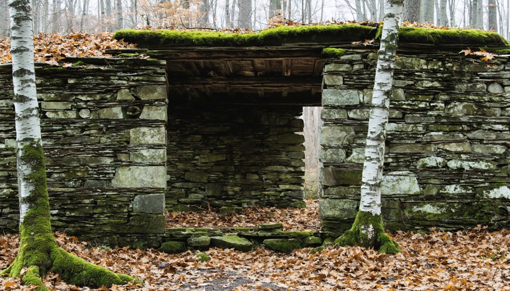
Unlike developed company towns such as Livermore with its hospital, Carrigain remained among the simplest logging camps, leaving behind only rotting foundations and overgrown rail grades that hikers occasionally stumble upon in the forest.
Logging Era Structures
While most hikers traverse the White Mountains unaware of the industrial past beneath their feet, Carrigain’s crumbling foundations tell a story of ambition and abandonment that unfolded across barely two decades.
You’ll discover stone foundation traces where steam-powered mills once processed millions of board feet. These logging camp remnants reveal how companies consolidated vast acreages and erected entire communities to extract timber wealth.
Physical evidence scattered throughout the forest includes:
- Foundation blocks marking worker housing locations from the early 1870s
- Metal brackets from log truck connectors along abandoned railroad beds
- Barrel rings and industrial artifacts gradually disappearing beneath forest succession
Trail Markers Today
Today’s Signal Ridge Trail traces those same logging corridors, though you’d struggle to follow it without careful preparation. Yellow blazes disappear after the first half-mile, leaving unmarked trail sections that demand constant map consultation. The 2012 relocations compound maintenance challenges—I’ve watched hikers miss the critical 2.4-mile turn where only stacked branches indicate you should veer sharply left from the brook.
Old routes lie blocked with logs, and beaver activity reshapes Carrigain Brook crossings after storms. Yet the footpath persists through sheer use, mud preserving boot-prints where paint would help. Near the summit cone, you’ll pass the warden’s foundations and that still-functioning well, reminders that even official infrastructure eventually succumbs when bureaucrats abandon their posts. Navigation here rewards self-reliance over dependence.
Gosport and the Isolated Island Settlement
Among New Hampshire’s most peculiar ghost towns, Gosport clung to Star Island—a windswept outcrop measuring just five-eighths of a mile long and one mile wide—from its first permanent settlement in 1677 until its formal disincorporation in 1876.
For two centuries, stubborn islanders defied isolation on this tiny Atlantic outpost before vanishing into New England’s forgotten history.
You’ll find fascinating evidence of this isolated community’s resilience in three key developments:
- Church construction from a 1685 Spanish shipwreck’s timber created the meeting house in the early 1700s
- Family ownership consolidated under the Caswells, who controlled one-third of island properties by 1866
- The Revolutionary War evacuation devastated population numbers permanently
The 1876 annexation to Rye ended centuries of stubborn independence. John R. Poor’s Oceanic hotel acquisition bought out remaining fishermen, transforming their hardscrabble existence into summer resort fantasy—erasing Gosport’s weathered reality.
Kilkenny’s Remote Mountain Community
How could a settlement survive where even the religious services descended into rum-soaked brawls? Kilkenny’s story answers: it couldn’t. Granted in 1774 in northernmost Coos County and named after Ireland’s Kilkenny, this remote mountain community embodied rugged isolation from its inception. By 1830, just 27 inhabitants clung to land better suited for forest animals than farming.
The extreme remoteness attracted those seeking freedom but proved their undoing. When leader Andrus abandoned his followers in 1800, John Gay assumed presidency of the failing settlement. Factory Hollow’s 1804 woolen mill offered brief hope until fire destroyed it in 1830. Another mill fire, combined with Civil War casualties, sealed Kilkenny’s fate. Today’s 2010 census confirms what decades foretold: zero residents in this White Mountain ghost town.
Little Canada and the Franco-American Legacy
Deep in the White Mountain region near Lincoln, a company town named “Little Canada” flourished briefly as witness to the wave of French-Canadian migrants who transformed New England’s industrial landscape.
Little Canada stood as living proof of French-Canadian migration reshaping New England’s mountain industries and communities.
Owner Matson built this settlement in the early 1900s to house workers for his logging operations and wagon hub factory. The 1912 census recorded 32 residents—families like the Pichettes and Gigners who’d fled Canadian poverty for opportunity.
Three key aspects defined Little Canada‘s Franco-American character:
- French-language schools supporting children’s cultural preservation
- Dense ethnic networks within boarding houses valued at $3,100
- Community resilience despite anti-Catholic tensions
These demographic shifts reshaped regional identity. After the 1915 mill fire, residents scattered. Highway construction later obliterated remaining foundations, erasing physical traces of this freedom-seeking community.
Frequently Asked Questions
Can Visitors Legally Explore the Ghost Town Sites in New Hampshire?
You’ll find some ghost towns legally accessible through National Forest trails, but you’ll face private property concerns and environmental protection regulations blocking many sites. I’ve researched archives showing trespassing arrests at gated locations, so verify access beforehand.
Are There Any Guided Tours Available for New Hampshire Ghost Towns?
Like abandoned trails reclaimed by forest, guided tour operators haven’t established formal routes through NH’s ghost towns. You’ll find historical preservation efforts focus on Portsmouth’s haunted sites instead, leaving authentic ghost towns like Livermore for your independent exploration and discovery.
What Artifacts Have Been Recovered From These Abandoned Settlements?
You’ll discover abandoned artifacts like stone tools at Mount Jasper, metal pipes and glass fragments in Livermore’s foundations, and historical relics including stone walls and hand-drawn maps preserved in Monson’s museum collections documenting settler life.
Do Any Ghost Towns Still Have Standing Structures to Visit?
You’ll find four ghost towns with standing structures: Monson Center’s restored Gould House museum, Russell-Colbath’s 1832 home, Livermore’s crumbling mill ruins, and Madame Sherri’s Castle ruins—though historic preservation efforts can’t save its dangerous architectural features from collapse.
How Did Residents Earn Income Before the Towns Were Abandoned?
You’d have earned income through resource extraction like logging and milling timber, or agricultural activities on scattered farms. Company towns provided sawmill wages, while tradesmen served lumber operations before poor soil and depleted forests forced everyone out.