To plan your ghost town road trip to Animas Forks, Colorado, start in Silverton and head northeast along County Road 2 into the San Juan Mountains. You’ll need a 4WD vehicle for the rugged 12-mile climb to 11,185 feet. Visit between late June and mid-September for the best conditions, and pack layers, water, and emergency gear. There’s far more to this haunted, high-altitude time capsule than you’d expect — and the full story is just ahead.
Key Takeaways
- Animas Forks sits at 11,185 feet in Colorado’s San Juan Mountains, 12 miles northeast of Silverton via County Road 2.
- A 4WD vehicle is essential, as the route follows unimproved roads with narrow switchbacks, steep drop-offs, and no nearby services.
- Visit between late June and mid-September for the safest, most accessible conditions; afternoon thunderstorms make an early start critical.
- Pack food, water, emergency gear, extra fuel, and layered clothing, as temperatures drop rapidly at high elevation.
- Extend your trip by exploring nearby ghost towns Engineer City, Capitol City, and Eureka along the 65-mile Alpine Loop Backcountry Byway.
What Makes Animas Forks One of Colorado’s Most Visited Ghost Towns?
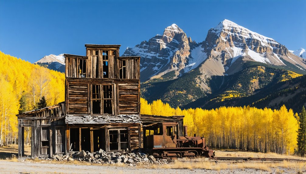
Perched at 11,185 feet in Colorado’s San Juan Mountains, Animas Forks isn’t just another crumbling ghost town — it’s a remarkably preserved window into the raw ambition of America’s mining era.
You’ll find standing structures, including the striking Duncan/Walsh House, that tell an unfiltered ghost town history most sites can’t match.
At its peak in 1883, 450 residents called this place home during summer months, supporting saloons, a newspaper, and even electricity.
That’s an audacious mining heritage carved from one of North America’s harshest environments.
What draws visitors isn’t just ruins — it’s the authenticity.
The Bureau of Land Management protects what remains, so you’re experiencing something genuinely untouched.
Animas Forks rewards the adventurous traveler willing to chase real history off the pavement.
How To Get To Animas Forks From Silverton
From Silverton, you’ll head 12 miles northeast into the rugged San Juan Mountains, where Otto Mears once carved a wagon road through the wilderness to connect fortune-seekers to one of North America’s highest mining camps.
The roads to Animas Forks are unimproved and demand a 4-wheel-drive vehicle — this isn’t a Sunday cruise, it’s a genuine backcountry commitment at elevations pushing past 11,000 feet.
You’ll navigate along the iconic 65-mile Alpine Loop Backcountry Byway, a route that traces the same treacherous terrain where miners once hauled gold and silver through punishing mountain winters.
Starting Point In Silverton
Silverton serves as your gateway to Animas Forks, sitting roughly 12 miles southwest of the ghost town along the Alpine Loop Backcountry Byway.
Before you leave, soak in Silverton‘s history — this Victorian-era mining hub shaped the same boom-and-bust cycles that ultimately swallowed Animas Forks whole.
Stock up on fuel, water, and supplies here, because once you head northeast into San Juan County’s rugged backcountry, you’re committed.
The road demands a capable 4-wheel-drive vehicle — ghost town myths of easy access have left unprepared travelers stranded at elevation.
Greene Street serves as your natural departure point, feeding directly onto County Road 2 heading northeast.
You’ll climb steadily toward 11,000 feet, trading Silverton’s familiar streets for raw mountain wilderness that hasn’t changed much since the 1880s.
Road Conditions And Requirements
Once you pull out of Silverton heading northeast, the pavement surrenders quickly to the unimproved dirt and rock of County Road 2 — and the mountain makes its expectations clear.
The 12-mile climb to 11,185 feet demands a 4-wheel-drive vehicle; this isn’t a suggestion but a genuine vehicle requirement that separates those who reach Animas Forks from those who turn back.
Narrow switchbacks, loose shale, and steep drop-offs make road safety a constant consideration. Check your brakes, carry extra water, and never attempt the route in threatening weather.
The Bureau of Land Management maintains oversight here, but the terrain enforces its own rules. Respect them, and you’ll earn arrival at one of North America’s most extraordinary high-altitude ghost towns.
Knowing your vehicle can handle the terrain is only half the equation — knowing where to point it completes the picture.
Animas Forks sits 12 miles northeast of Silverton along the legendary 65-mile Alpine Loop Backcountry Byway, a route threading through historic mining country that once carried prospectors chasing silver and gold dreams.
From Silverton, head northeast on County Road 2. The Alpine scenery unfolds aggressively — jagged peaks, crumbling mine structures, and creek crossings demanding your full attention.
You’re retracing Otto Mears’ original 1875 wagon road, built specifically to open this remote corridor.
Stay oriented with a detailed topographic map or reliable GPS. Cell service disappears fast out here.
The Bureau of Land Management manages the route, but the wilderness answers to nobody.
The Best Time of Year To Make the Trip
Because Animas Forks sits at over 11,000 feet, timing your visit isn’t just a matter of convenience—it’s a matter of survival strategy. The best seasons are summer and early fall, roughly late June through mid-September, when the unimproved roads thaw and open for 4-wheel-drive travel.
Weather considerations matter enormously here. Afternoon thunderstorms roll in fast during July and August, so start early and watch the sky.
By October, early snowfall reclaims these mountains with authority—just as residents once fled annually to Silverton when winter made survival brutal.
Spring looks tempting on a map but delivers mud, ice, and impassable terrain.
Choose your window wisely, move deliberately, and you’ll reach one of North America’s most remarkable abandoned mining camps on your own terms.
What’s Still Standing at Animas Forks Today
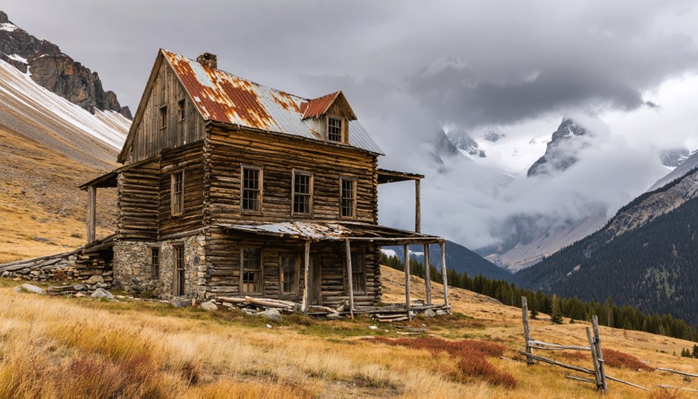
Several structures have survived the combined forces of avalanche, fire, and a century of brutal winters—and standing among them, you feel the weight of what this place once was.
These historic structures tell Animas Forks’ story more honestly than any museum could. The crown jewel is the Duncan/Walsh House, a two-story wood-frame home built in 1879 that’s remarkably intact given the natural beauty and brutal conditions surrounding it at 11,000 feet.
You’ll also find the skeletal remains of the Gold Prince Mill and the Frisco Mill ruins nearby. The Bureau of Land Management preserves what remains, so respect the site—don’t climb on structures or remove anything.
Walk the grounds slowly. Every rotting timber and collapsed wall represents someone’s hard-won life in one of North America’s highest mining camps.
Why Did Everyone Leave Animas Forks?
As you stand among Animas Forks’ weathered ruins, you can’t help but wonder what drove everyone away from a town that once buzzed with 450 residents.
The silver market’s catastrophic collapse in 1893 gutted the economy practically overnight, but the town had already taken a brutal punch two years earlier when an 1891 fire torched 14 buildings and caused $20,000 in damage.
Layer on top of that the merciless winters that buried homes under crushing snowpack, and you’ll quickly understand why residents didn’t so much leave Animas Forks as they escaped it.
Silver Market’s Fatal Crash
When silver prices collapsed in 1893, Animas Forks didn’t slowly fade — it emptied. The federal government’s repeal of the Sherman Silver Purchase Act gutted silver mining overnight, and the economic impact hit mountain camps like this one hardest.
Miners who’d endured brutal winters, 25-foot blizzards, and tunnel-digging just to reach their neighbors suddenly had no reason to stay. The reward wasn’t worth the punishment anymore.
Businesses shuttered. Families packed what they could carry and descended to lower ground. The Gold Prince Mill held on until 1910, and the post office kept its doors open until 1915, but the town’s spirit had already gone.
Walking those empty streets today, you’re standing inside a decision thousands of people made simultaneously — leave or lose everything.
Devastating Fire And Exodus
The silver crash wasn’t the only blow Animas Forks absorbed before it went quiet. In 1891, fire tore through town, destroying 14 buildings and causing $20,000 in damage. The fire aftermath tested community resilience hard, but residents rebuilt — temporarily.
Three forces ultimately drove everyone out:
- The 1891 fire erased nearly a third of the town’s structures overnight.
- The 1893 silver market collapse gutted economic purpose entirely.
- The Gold Prince Mill’s 1910 closure eliminated the last viable industry.
Brutal Winter Conditions
Winter at Animas Forks didn’t just inconvenience residents — it buried them alive. At 11,185 feet, harsh climate made year-round habitation nearly impossible. Every fall, residents packed up and fled to Silverton, surrendering the town to brutal snowpack.
The 1884 blizzard became legendary. Twenty-five feet of snow collapsed the landscape, forcing residents to dig tunnels between buildings just to survive.
Winter survival wasn’t romantic — it demanded constant wood gathering, physical exhaustion, and sheer stubbornness.
When you stand here today, imagine hauling fuel through chest-deep drifts just to keep a stove burning. Most people couldn’t sustain it. The mountain always won.
That relentless seasonal exodus slowly drained Animas Forks of its population, making abandonment inevitable long before the mines ever ran dry.
What To Bring for the Drive to Animas Forks
Reaching Animas Forks at 11,185 feet demands serious preparation, so pack your 4WD-ready essentials before you leave Silverton’s pavement behind.
The Alpine Loop’s unimproved roads punish the unprepared, but reward those who plan smart.
Your road trip essentials checklist:
- Emergency gear – first aid kit, tire repair kit, tow straps, and jumper cables for remote breakdowns
- Navigation tools – offline maps or a paper topo, since cell service vanishes quickly at elevation
- Layered clothing and supplies – temperatures drop fast at 11,000 feet, so bring food, water, and weather-appropriate layers
Stop at scenic viewpoints along the byway—you’ll want your camera ready.
Those ghost town ruins earned their history through brutal conditions, and you’re about to witness exactly why.
Other Animas Forks-Area Stops on the Alpine Loop
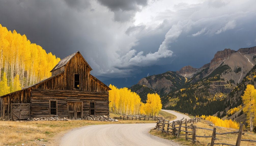
Animas Forks isn’t the only ghost worth chasing along the Alpine Loop’s 65 miles of backcountry road. Eureka sits just downhill, where mill parts from Animas Forks were relocated in 1917 — its historical significance rooted in industrial-era ambition and silver-boom desperation.
Ruins frame dramatic mountain backdrops perfect for wide-angle shots; arrive early for softer light and fewer shadows cutting across crumbling structures. Photography tips: shoot from lower angles to emphasize abandoned machinery against open sky.
Further along, Engineer City and Capitol City offer their own weathered remnants and sweeping ridgeline views. Each stop rewards curiosity differently — collapsed walls, rusted equipment, silent foundations.
String them together into a single loop and you’ve built a full day of high-altitude exploration on your own terms.
How To Visit Animas Forks Without Getting Into Trouble
Stringing together a full loop of ghost towns sounds thrilling — and it’s — but the Alpine Loop doesn’t forgive careless planning.
Follow these Safety Tips before you roll out:
- Drive a true 4WD vehicle — soft-roaders get stranded above 11,000 feet where cell service vanishes.
- Start early, because afternoon thunderstorms build fast over the San Juans and turn rocky trails treacherous.
- Pack water, emergency gear, and extra fuel; no services exist between Silverton and Animas Forks.
Wildlife Awareness matters out here too.
Black bears and mountain goats roam freely, so keep your distance and secure your food.
The BLM manages this land, and you’re a guest in it. Respect it, and it’ll reward you with one of the West’s most breathtaking drives.
Frequently Asked Questions
Can You Camp Overnight at the Animas Forks Ghost Town Site?
The knowledge doesn’t confirm camping regulations or ghost town amenities for overnight stays. You’ll want to contact the Bureau of Land Management directly—they manage the site and can clarify your overnight freedom at this hauntingly historic, high-altitude destination.
Is There an Entrance Fee to Visit Animas Forks?
You won’t pay an entrance fee to explore Animas Forks! The Bureau of Land Management keeps this treasure free, so you can roam its ghost town history and scenic routes with total, untamed freedom.
Are Pets Allowed When Visiting the Animas Forks Historic Site?
The knowledge base doesn’t specify pet policies for Animas Forks. Since the BLM manages the site, you’ll want to contact them directly to confirm dog friendly activities before you saddle up for your historic adventure!
Does Animas Forks Have Any Cell Phone Signal or Emergency Services Nearby?
Don’t count on cell service at this remote 11,185-foot ghost town! Save your emergency contacts before you venture out, because Animas Forks’ rugged, untamed wilderness rewards bold explorers who come fully self-reliant and prepared.
Are Guided Tours of Animas Forks Available for Visitors?
Like pioneers forging new trails, you’ll find no formal guided exploration here — Animas Forks lets you roam freely. Yet the site’s historical significance speaks volumes through its preserved ruins, inviting your own adventurous self-guided discovery.
References
- https://en.wikipedia.org/wiki/Animas_Forks
- https://www.durango.com/animas-forks/
- https://janmackellcollins.wordpress.com/2025/01/13/a-visual-history-of-animas-forks-colorado/
- https://www.blm.gov/visit/animas-forks
- https://milliverstravels.com/2014/02/animas-forks-colorado/
- https://www.youtube.com/watch?v=5o4zzFRWet4
- https://www.legendsofamerica.com/animas-forks-colorado/


