
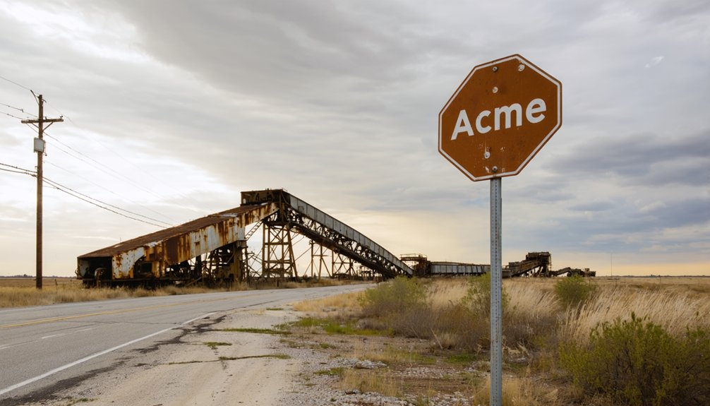
Navigate to Acme’s haunting concrete ruins using GPS coordinates 34.79896°N, -98.0192086°W in southwestern Grady County, where weathered mill foundations stand at 1,286 feet elevation. You’ll need reliable transportation for unpaved county roads, sturdy boots for crumbling structures, and essential supplies since the nearest services are miles away. Spring and fall offer ideal visiting conditions for exploring the scattered foundations where 125 workers once processed gypsum before catastrophic 1926-1927 floods buried everything under sand, sealing this boomtown’s fate and leaving behind secrets etched in deteriorating concrete.
Key Takeaways
- Acme is located in southwestern Grady County at coordinates 34.79896°N, -98.0192086°W at 1,286 feet elevation.
- Bring GPS navigation tools and supplies, as addresses are unreliable and unpaved county roads may deteriorate in poor conditions.
- Visit during spring or fall for ideal conditions, and wear sturdy boots for navigating uneven terrain and crumbling structures.
- Explore scattered concrete ruins of the 1911 Acme Cement and Plaster Company mill and a few remaining house foundations.
- Extend your trip to nearby Cement, Oklahoma, for its historical museum, fishing, and camping opportunities.
The Rise and Fall of a Gypsum Boomtown
When the Acme Cement and Plaster Company erected its massive mill and power plant in 1911, the machinery stood so enormous that workers had to construct the buildings around the equipment itself. This industrial marvel soon employed 125 workers who produced eight railcar loads daily from nearby Grady County gypsum beds.
Regional railroad infrastructure expanded when the Chicago, Rock Island and Pacific Railroad built a dedicated spur to the thriving operation.
The community flourished with a general store, brick schoolhouse, and gymnasium serving families. Worker housing conditions improved as the town established itself, complete with its own post office in 1913.
However, when floods buried new gypsum deposits under sand in 1926-1927 and the Great Depression arrived, operations became unsustainable. The company shuttered everything in 1930.
Getting to Acme: Directions and Coordinates
The abandoned mill town sits in southwestern Grady County at coordinates 34.79896°N, -98.0192086°W, roughly three miles west of Rush Springs, Oklahoma. You’ll find concrete ruins from gypsum mill operations scattered across the landscape at 1,286 feet elevation. The Rock Island railway spur that once transported manufactured products was abandoned in 1930, so you’ll need reliable county road conditions to reach this remote location.
GPS coordinates and sturdy vehicles replace historic railway routes when exploring this elevated gypsum ghost town west of Rush Springs.
Before heading out, prepare for limited infrastructure:
- Navigation tools are essential – GPS coordinates work better than addresses in this ghost town
- Bring supplies from Rush Springs – no commercial facilities exist at the site
- Check county road conditions – unpaved routes may deteriorate after weather events
Duncan serves as your nearest regional hub for thorough trip preparation.
What Happened to Acme’s Gypsum Industry
The gypsum industry that gave birth to Acme burned bright and fast, with 125 workers once producing six to eight railcar loads daily before the local deposits ran dry within just twelve years.
When operators extended a narrow-gauge railroad to tap gypsum beds near the Little Washita River, they bought themselves time—until catastrophic floods in 1926-1927 buried those reserves under several feet of sand.
The Great Depression delivered the final blow in 1930, shuttering the mills and railroads that had transformed this patch of Oklahoma prairie into a thriving industrial town.
Peak Production and Depletion
Within just four years of Oklahoma’s statehood, the Acme Cement and Plaster Company transformed this stretch of prairie into an industrial hub. By the early 1920s, you’d have witnessed impressive production yield as the mill churned out gypsum products around the clock. The operation’s gypsum quality attracted nationwide buyers, with six to eight railcars departing daily.
At peak capacity, the plant employed 100 to 125 workers who extracted local gypsum deposits with remarkable efficiency. But freedom from resource constraints proved fleeting:
- Local gypsum beds exhausted by 1923—just twelve years after opening
- Company built narrow-gauge railroad to Little Washita River deposits
- Operations collapsed by 1930 as Depression-era economics made distant mining unprofitable
The venture’s rapid decline left behind crumbling structures you’ll explore today.
Floods and Final Closure
When heavy rains swept across the central United States in 1926-1927, triggering the catastrophic Mississippi River floods, the Little Washita River near Acme swelled beyond its banks and released devastation on the company’s lifeline. Several feet of sand buried the gypsum beds, choking the narrow-gauge railroad tracks that fed the mill. These broader regional impacts forced workers to excavate contaminated deposits, transforming profitable mining into backbreaking labor.
The company persisted through the late 1920s, but mounting costs from sand removal made operations unsustainable. When the Great Depression struck in 1930, the Acme Cement and Plaster Company shuttered its mill permanently. Equipment losses accelerated the town’s collapse. By 1931, even the post office closed, leaving only concrete ruins where industry once thrived.
The Devastating Floods That Sealed Acme’s Fate
You’re standing in a landscape transformed by catastrophic floods that struck in 1926 and 1927, when the Washita River discharged, unleashed, or released torrents that buried Acme’s streets and buildings under tons of sand and debris.
The relentless water didn’t just recede—it left behind a suffocating blanket of sediment that made rebuilding impossible and choked off the town’s already-struggling gypsum operations. What began as a natural disaster became an economic death sentence, forcing residents to abandon their homes and businesses as the river literally erased Acme from viability.
1926-1927 Flood Events
Through 1926 and into 1927, relentless rains pounded the central United States, turning the mighty Mississippi River and its tributaries into instruments of destruction. The Little Washita River near Acme swelled beyond recognition as the Mississippi remained at flood stage for a record 153 days.
By spring 1927, the catastrophe reached devastating proportions:
- 145 levee breaches along the Mississippi created unstoppable torrents
- Over 27,000 square miles submerged across ten states
- 630,000 to 700,000 people displaced from their homes
Without effective watershed management or flood prevention measures, communities like Acme stood defenseless. The floodwaters buried Acme’s essential gypsum beds under feet of sand, crippling the town’s economic lifeline. By 1930, the mill shut down permanently, abandoning Acme to become Oklahoma’s haunting reminder of nature’s overwhelming power.
Sand Burial Consequences
As the floodwaters receded from the Little Washita River valley, they left behind a devastating legacy that would strangle Acme’s future. Several feet of sand smothered the newly developed gypsum beds that had sustained the town’s expansion.
You’ll find no efficient sand removal methods existed in 1927—workers laboriously excavated by hand, transforming mining operations into unprofitable ventures. The company persisted through 1930, but escalating costs overwhelmed revenue as each shovelful revealed the futility of their struggle.
Without long term flood mitigation strategies to protect riverside deposits, economic collapse became inevitable. By 1930, the mill fell silent, narrow-gauge tracks were abandoned, and Acme’s residents scattered. Today, you’re witnessing what remains when nature reclaims industrial ambition.
Economic Impact Analysis
When catastrophic floods strike Oklahoma’s river valleys, they don’t merely destroy buildings and roads—they dismantle entire economic systems that communities depend upon. You’ll find that flooding’s true cost extends far beyond immediate damage tallies.
The 1981 south-central Oklahoma floods delivered $115 million in destruction, while 1984’s Tulsa disaster cost $108 million. These aren’t isolated incidents—they’re cyclical recessions that reshape regional economies.
Consider flooding’s cascading economic devastation:
- Infrastructure collapse shuts down navigation systems, requiring expensive dredging operations
- Agricultural losses from destroyed farmland force long-term land use changes
- Population displacement eliminates local consumer bases and tax revenue
When 30,000 people evacuated in 1986, they didn’t just leave temporarily—many never returned, permanently eroding Acme’s economic foundation.
Exploring the Concrete Ruins Today
The concrete ruins of the Acme Cement and Plaster Company stand as weathered sentinels three miles west of Rush Springs, marking where a thriving industrial operation once employed over 100 workers. Today, you’ll find minimal visible structures at this ghost town perched at 1,286 feet elevation. The mill machinery vanished long ago, and supporting buildings like the school, boarding houses, and general store were demolished decades past.
Large concrete remnants visible through the 1980s met their end when they were torn down for ditch construction. What remains creates a haunting historical atmosphere—scattered concrete foundations and a few persistent houses amid the landscape. You’re standing on ground where 6-8 railcar loads of gypsum products departed daily before the devastating 1927 flood buried everything under sand.
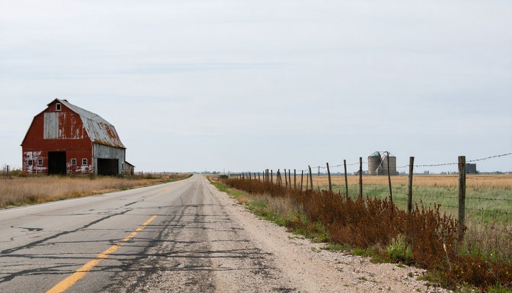
What You’ll See Along the Old Main Road
Scattered foundations and weathered concrete slabs mark your path along County Road 2790, where Acme’s industrial heart once pumped out 6-8 railcar loads daily. You’ll discover a landscape transformed by time and nature’s fury—those 1926-1927 floods that buried everything under sand. The architectural styles of Acme’s mill vanished when locals repurposed the concrete for ditches in the 1980s.
Today’s roadside reveals:
- Aging houses and trailers dotting the hillside where workers once lived
- No historical markers identifying the Acme Cement location
- Tourism infrastructure completely absent from this forgotten corner
Access remains straightforward via Highway 81 south from Oklahoma City, then Highway 1520. You’re free to explore unmarked history—no fees, no guides, just raw abandonment.
Best Time to Visit and What to Bring
Spring and fall emerge as your ideal windows for exploring Acme’s skeletal remains, with temperatures hovering between 60-80°F that let you traverse County Road 2790‘s scattered foundations without battling Oklahoma’s notorious summer heat. Summer’s 90°F-plus temperatures will sap your energy during self guided tours, while winter’s cold fronts transform unpaved approaches into treacherous routes.
Pack sturdy boots for maneuvering crumbling structures and uneven terrain where the 1911 cement mill once thrived. Bring ample water, especially if you’re venturing beyond shoulder season’s comfortable embrace. Photography gear captures haunting details best during fall’s clear visibility. Since local guidebooks rarely detail Acme’s backroads, load GPS coordinates beforehand—this forgotten junction won’t announce itself. Navigation tools prove essential where county road designations replace street signs and civilization feels wonderfully distant.
Combining Your Trip With Nearby Cement, Oklahoma

Just twelve miles southwest of Acme’s abandoned foundations, Cement stands as a living counterpoint to your ghost town exploration—a small town that survived where its neighbor didn’t. This working community offers practical amenities your adventure requires while maintaining its own authentic Oklahoma character.
Cement thrives just twelve miles from Acme’s ruins—a living town offering modern amenities while preserving authentic Oklahoma spirit.
Essential stops in Cement include:
- Local diners serving genuine small-town hospitality and home-cooked meals
- Cement Historical Museum showcasing regional pioneer heritage
- Nearby Fort Cobb Lake for fishing and camping
You’ll find limited lodging options in Cement itself, but nearby Anadarko provides hotels and motels. The recreational activities around Fort Cobb Lake—just minutes away—let you extend your ghost town pilgrimage into nature. This pairing creates a complete southwestern Oklahoma experience.
Frequently Asked Questions
Are There Any Safety Concerns When Exploring the Abandoned Structures at Acme?
You’ll face serious structural stability concerns exploring Acme’s crumbling buildings, as undermined foundations could collapse without warning. Trespassing risks include legal consequences and exposure to toxic chat dust that’s contaminated the entire area with dangerous heavy metals.
Is Permission Required to Access the Private Property Where Ruins Are Located?
You’ll find no posted restrictions documented at Acme’s roadside ruins, but privacy concerns exist near occupied homes. Trespassing risks remain real—while concrete foundations appear accessible, you should respect private property markers and stick to public roads for safe exploration.
What Wildlife or Animals Might Visitors Encounter at the Ghost Town Site?
You’ll encounter hawks circling overhead, stray dogs roaming the ruins, and diverse bird species across the prairie. Watch for potential snake sightings in warm weather, plus rabbits and foxes exploring abandoned structures throughout this wild, untamed landscape.
Are There Any Local Legends or Paranormal Stories Associated With Acme?
You’ll find folklore surrounding the town centers on the nearby Indian burial ground where Stanley Pittman lives. While specific local haunting tales aren’t documented, the abandoned ruins and cemetery location naturally inspire ghost stories among adventurous visitors exploring freely.
Can You Visit the Nearby Indian Burial Ground Mentioned in the Area?
You can’t freely visit the burial ground due to restricted access policies and private land boundaries. Respect for Native American artifacts and sacred sites requires contacting Grady County historical societies or tribal nations before attempting any visit.


