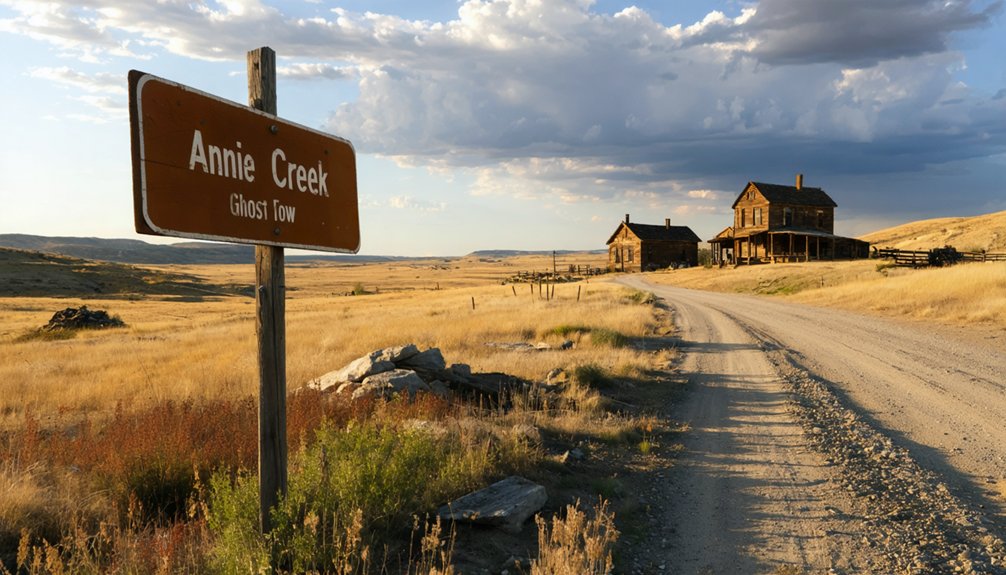
You’ll find the ghost town of New Reliance buried under tailings about 8 kilometers southwest of Lead, South Dakota. Take Annie Creek Road 3.8 miles past Spearfish Canyon Lodge, though you’re better off parking at the canyon road and hiking the final mile—those fist-sized rocks will shred your tires. The crumbling mill foundations and gaping mine shafts at 6,001 feet elevation tell haunting stories of the 150-ton cyanide facility that poisoned Annie Creek until authorities shut it down in 1906. Plan your visit between late spring and early fall for safer conditions.
Key Takeaways
- Annie Creek is located 8 kilometers southwest of Lead, South Dakota, within Spearfish Canyon in Black Hills National Forest.
- Access via Annie Creek Road, 3.8 miles past Spearfish Canyon Lodge; park at canyon road and hike one mile.
- Visit between late spring and early fall to avoid winter snows and treacherous conditions from sudden summer storms.
- Explore New Reliance Mine ruins including crumbling mill foundations, mine shafts, and remnants of the 1903-1916 mining operation.
- Exercise extreme caution around unstable buildings, gaping mine shafts, and aging structures throughout the abandoned town site.
Discovering Annie Creek’s Location and Geography
Tucked deep within the rugged Black Hills National Forest of South Dakota, Annie Creek carves its modest path through Lawrence County, approximately 8 kilometers southwest of the historic mining town of Lead. You’ll find this 2.1-mile waterway nestled in Spearfish Canyon‘s embrace, three-quarters of the way from Spearfish itself.
At 5,154 feet above sea level, the creek drains 3.72 square miles of wilderness where vegetation patterns shift from ponderosa pine to spruce forests. The mineral composition here tells stories of the Bald Mountain Mining District‘s golden past.
To reach it, navigate Annie Creek Road about 3.8 miles from Spearfish Canyon Lodge. The coordinates N44.32721°, W103.89298° will guide you to where this six-inch-deep stream beckons adventurers seeking unmarked trails and forgotten mining territory. Just 1.6 miles away, Elk Mountain rises as a prominent landmark in the surrounding landscape. The U.S. Geological Survey Geographic Names Information System officially documents this river’s location and characteristics.
The Rich Mining Heritage of New Reliance Mine
What secrets lie buried beneath 7,500 feet of abandoned tunnels at 6,001 feet elevation? You’ll discover the New Reliance Mine’s turbulent past when exploring Annie Creek. Beginning in 1903, miners extracted low-grade gold and silver ore through a twenty-ton cyanide mill—converted from an abandoned Spearfish chlorination facility.
Beneath 7,500 feet of tunnels at 6,001 feet elevation lies the New Reliance Mine’s forgotten history of gold, silver, and cyanide processing.
The operation processed potentially 750,000 tons worth four to eight dollars each.
But freedom comes with consequences. The cyanide mill pollution devastated Spearfish and Annie Creek, poisoning fishing grounds until courts shut down operations in April 1906. A settling dam failure that same year compounded the environmental disaster.
You’ll find remnants of the Ak-Sar-Ben, Bunker Hill, and Iron Duke claims scattered across this Black Hills National Forest site—evidence of ambitious dreams meeting harsh mining operations challenges. The Annie Creek Mining Co. operated this Lawrence County replacement deposit as a past producer, though precise production figures remain unverified in historical records. Watson Parker documented the New Reliance Boarding House in 1976, capturing the lodging facility that once housed miners working these claims.
What Remains: Exploring the Buried Town Site
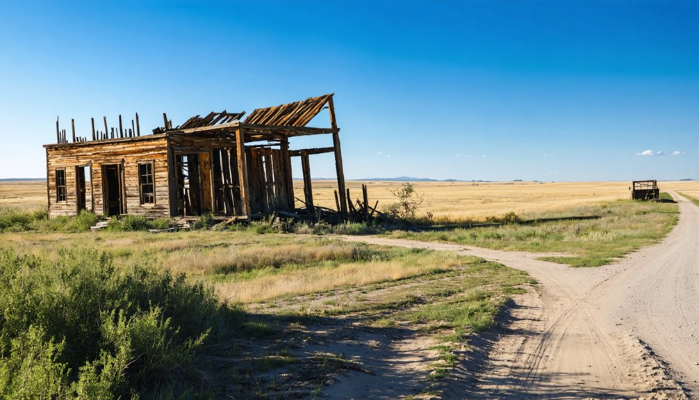
Along the banks of Annie Creek, you’ll spot the crumbling remains of New Reliance Mine—boarding houses with missing roofs, a weathered office building, and scattered mine structures slowly surrendering to time.
These 1960s-70s ruins mark the final chapter of operations that once pulled $600,000 in gold from the earth before closing in 1916. Keep your distance from the gaping mine shafts and unstable buildings; these skeletal structures are picturesque from afar but dangerous up close.
Much of the original town now lies buried under tailings from an open pit mine, leaving only fragments of Annie Creek’s mining legacy visible to ghost town enthusiasts. Like other Black Hills ghost towns, Annie Creek has lost the original goals and ambitions that once gave it community existence, though its ruins and memories still inhabit the site.
New Reliance Mine Ruins
Deep within the Black Hills National Forest at 6,001 feet elevation, the New Reliance Mine ruins sprawl across a haunting landscape where nature’s reclaimed what industry abandoned. You’ll discover gaping shafts, crumbling mill foundations along Annie Creek, and scattered waste piles—remnants of the 150-ton cyanide processing facility built in 1906.
The site’s stark beauty masks its toxic past; cyanide pollution decimated fish populations and discolored streams for weeks after spills. Like the ongoing remediation work at the Gilt Edge Mine Superfund site, environmental cleanup efforts continue to address the legacy of abandoned mining operations throughout the region.
Today’s environmental remediation efforts haven’t erased all evidence of the operation’s 7,500 feet of underground workings. Tread carefully around unstable structures and open mine shafts. The old boardinghouse is long gone, but you’ll find authentic industrial archaeology spanning the property’s boundaries at coordinates 44.3375° N, -103.86361° W—a photographer’s dream despite ongoing reclamation efforts.
Safety Around Disrepair Structures
Unlike the scattered ruins at the New Reliance Mine, Annie Creek’s original town site lies completely buried beneath open pit mine tailings—a sobering reminder that not all ghost towns leave visible traces. You’ll find only scattered evidence along the creek banks where mining activity once thrived.
The terrain here demands respect—those tailings create treacherous badlands riddled with hidden crevices that’ll catch you off-guard. Focus on traversing uneven terrain carefully, especially where erosion’s carved unpredictable channels. Bring solid boots and watch every step—this buried town tests your backcountry skills. The freedom to explore comes with accepting these harsh realities.
What few collapsing building remains exist near the drainage require wide berth. Don’t attempt entering any framework you encounter; rotted supports give way without warning. Like nearby Rochford’s Moonshine Gulch Saloon, some historic structures have survived the decades, but Annie Creek’s few remaining buildings lack such preservation. Some ghost towns like Barren have no remaining structures at all, having completely vanished from the landscape over time.
Getting There: Routes and Road Conditions
You’ll find Annie Creek Road as the first right turn past Elmore when heading north from Cheyenne Crossing—look for the sign roughly 3.8 miles from Spearfish Canyon Lodge. The road surface bristles with fist-sized sharp rocks that’ll threaten your tires, so consider parking at the canyon road and hiking the mile to the trailhead instead.
Time your visit between late spring and early fall, since winter snows make both the access road and creek crossings treacherous, and sudden summer thunderstorms can turn the creek bed into a rushing hazard within minutes. When exploring the area, exercise caution around aging structures and watch for potential safety hazards common to abandoned historical sites.
Primary Access Routes
Reaching Annie Creek requires traversing Spearfish Canyon‘s winding route until you spot the Annie Creek Road sign on your right, approximately 3.8 miles past Spearfish Canyon Lodge.
You’ll find this turnoff about three-quarters through the canyon from Spearfish, roughly two miles beyond Latchstring. The driving conditions deteriorate quickly once you leave the main canyon road—Annie Creek Road bristles with fist-sized, sharp rocks that’ll shred tires without mercy. Most adventurers park at the intersection and hike the mile to the unmarked trailhead instead.
This difficult terrain filters out casual tourists, preserving the ghost town’s solitude for those willing to earn it. From Cheyenne Crossing, head north and watch for that first right turn at the Annie Creek sign past Elmore.
Seasonal Weather Considerations
Four distinct seasons transform Annie Creek Road from a challenging drive into an outright gamble with nature. Winter demands constant vigilance—check SD511’s interactive map before departure, as conditions shift faster than plow crews can respond.
Spring brings the real danger: snowpack melt patterns create deceptive waterways across Rapid Creek tributaries, while ice accumulation risks persist when temperatures plummet 20 degrees after the 4pm SDDOT update.
Summer’s your window—dust and loose gravel beat black ice any day. Fall’s early snow advisories hit suddenly; those pre-winter webinars aren’t just bureaucratic theater.
Download the 511 app, enable those text alerts for Interstate closures, and remember: SafeTravelUSA’s cameras show reality, not optimism. Your freedom depends on respecting nature’s timeline.
Best Times to Visit and Weather Considerations
While summer draws the biggest crowds to Annie Creek, timing your ghost town road trip during the shoulder seasons rewards you with solitude and comfortable exploring conditions.
Late September through early October delivers peak fall colors with highs in the 70s and virtually empty trails—you’ll have the abandoned structures to yourself. Understanding crowd patterns helps you dodge the chaos: 90% of visitors descend between Memorial Day and Labor Day, with early August bringing Sturgis Rally traffic that’ll test your patience.
Skip the summer mob scene—fall’s uncrowded trails and perfect weather make late September the smart choice for ghost town exploring.
Spring’s unpredictable weather and limited service availability make it risky for road-trippers, though late May offers improving conditions. Winter shuts down most attractions entirely.
Your sweet spot? That magical first October week when golden aspens frame weathered buildings, and the only footsteps in the dust are yours.
Exploring Black Hills Ghost Towns Beyond Annie Creek
Annie Creek might anchor your ghost town adventure, but the Black Hills hide dozens of weathered mining camps within easy striking distance—each with its own story of boom, bust, and abandonment.
Head north to Galena, where Sarah Campbell made history filing the first woman’s mining claim in 1876. You’ll find gaping shafts and historic milling equipment rusting beside eroded tailings.
Seventeen minutes away, Spokane‘s skeletal remains tell of silver and lead fortunes that collapsed by 1940.
Rochford’s old Standby Mine looms over Irish Gulch, its mill ruins commanding the hillside. Near Mystic, frontier town architecture dots the railroad corridor where miners once restocked supplies.
Don’t miss Etta—just five minutes from Keystone—where tin and lithium operations left behind cassiterite processing structures. Over 600 ghost towns await your exploration.
Safety Tips for Visiting Mining Ruins
Those rusted headframes and crumbling mill foundations you’ll encounter hide dangers that persist decades after the last miners clocked out. Abandoned mine collapse risks remain real—sinkholes forty feet deep have swallowed ground in areas with century-old mining operations, and underground voids can give way without warning.
Before exploring, take thorough site precautions: never enter unstable structures or underground passages. Test ground stability ahead of you, especially near tailings piles and old shaft openings. The difficult trail to Annie Creek Falls’ bottom actually protects you by limiting access to hazardous zones.
Bring water—don’t drink from contaminated streams where arsenic and cyanide still lurk. Stay on established paths, respect closure signs, and tell someone your route. These ghost towns offer incredible history, but they’ll test your judgment.
Preserving History: Responsible Ghost Town Tourism
When you photograph that weathered wooden headframe against South Dakota’s big sky, you’re capturing more than a striking image—you’re documenting a fragile piece of American history that won’t survive careless visitors.
Annie Creek’s abandoned structures tell cultural narratives of miners who risked everything for silver dreams, and your choices matter. Leave artifacts where they lie—that rusted tin cup tells stories future explorers deserve to discover.
Support the local economy by grabbing lunch at nearby cafes and booking tours with community guides who share firsthand knowledge passed down through generations. This community empowerment sustains both heritage and livelihoods.
Read up on Annie Creek’s history before you arrive. Tread lightly, speak quietly near structures, and remember: you’re a temporary guest in someone’s permanent legacy.
Frequently Asked Questions
Are There Any Guided Tours Available for Annie Creek Ghost Town?
No guided tours availability exists specifically for Annie Creek—you’ll tackle this adventure solo. Nearby Deadwood offers guided tour packages for ghost towns and haunted sites, but Annie Creek remains unmarked wilderness requiring your own navigation skills and climbing gear.
Can I Camp Overnight Near the Annie Creek Site?
Nearby camping availability isn’t documented for Annie Creek specifically, so you’ll need to scout alternative spots in the area. Check seasonal weather conditions before heading out—South Dakota’s elements can shift quickly, demanding flexibility and preparedness.
Is Cell Phone Service Available in the Annie Creek Area?
Cell phone service is extremely limited in Annie Creek’s remote location. You’ll likely find spotty signal strength at best, with minimal data coverage. Download offline maps beforehand and don’t rely on your phone for navigation or emergencies out there.
Are Dogs Allowed When Exploring the Annie Creek Ruins?
Dog-friendly policies aren’t officially posted at Annie Creek ruins, and you won’t find on-site pet facilities. However, you’re free to bring leashed dogs while exploring responsibly. Watch for hazardous mining debris and respect any private property boundaries you encounter.
What Photography Equipment Works Best for Capturing the Mining Ruins?
You’ll want wide-angle lenses to capture sprawling mining structures and a sturdy tripod for stability in uneven terrain. Action cameras work great for dark interiors, letting you roam freely while documenting these hauntingly beautiful abandoned spaces.
References
- https://www.ghosttowns.com/states/sd/anniecreek.html
- https://www.sdpb.org/rural-life-and-history/2023-08-21/some-black-hills-ghost-towns-and-their-origins
- https://www.sdhspress.com/journal/south-dakota-history-2-2/some-black-hills-ghost-towns-and-their-origins/vol-02-no-2-some-black-hills-ghost-towns-and-their-origins.pdf
- https://www.blackhillsbadlands.com/blog/post/old-west-legends-mines-ghost-towns-route-reimagined/
- https://en.wikipedia.org/wiki/List_of_ghost_towns_in_South_Dakota
- https://thehillsiwander.files.wordpress.com/2016/12/historic-preservation-of-the-northern-black-hills1.pdf
- https://explore.digitalsd.org/digital/collection/WPGhosttown/id/272/
- https://www.southdakotamagazine.com/the-humor-of-rochford
- https://history.sd.gov/preservation/docs/RuralButteMeadeCo.pdf
- https://topoquest.com/place/south-dakota/stream/annie-creek/1261192


