
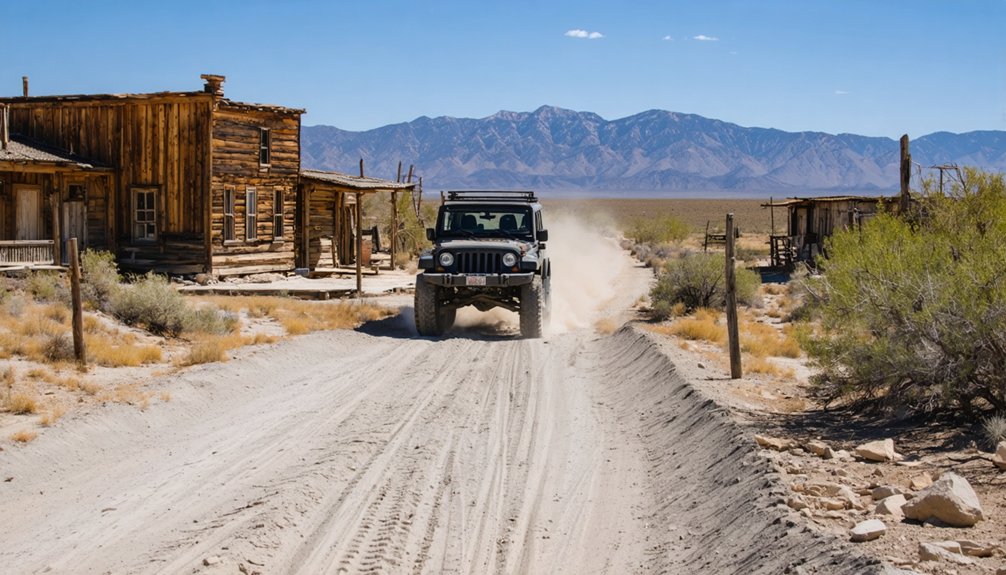
You’ll find Battle Creek’s haunting remnants 50 miles southwest of Battle Mountain, accessible only by high-clearance vehicles traversing unpaved roads through Nevada’s remote backcountry. Make Battle Mountain your essential supply hub—it’s your last chance for fuel, food, and lodging before venturing into this 1907-1959 mining district where scattered foundations and mill ruins whisper stories of three distinct boom periods. Seasonal conditions can render routes impassable, so experienced desert travelers should pack emergency supplies and plan carefully to uncover the archaeological treasures awaiting your discovery.
Key Takeaways
- Battle Creek is located 50 miles southwest of Battle Mountain, accessible only by unpaved roads requiring high clearance vehicles.
- Use Battle Mountain as your base camp for last reliable fuel, food, lodging, and essential supplies before heading out.
- Plan for seasonal road conditions that can make routes impassable due to spring runoff or summer dust storms.
- Bring emergency supplies and prepare as an experienced desert traveler when visiting this remote archaeological site.
- Explore scattered 1907 community remnants, 1917 mill foundations, and 1950s mining workings while respecting preservation status.
The Rise and Fall of Battle Creek Mining Operations
While prospectors had been eyeing the Battle Mountain area’s lode deposits since 1866, the district didn’t officially organize until 1867, when copper discoveries in north Lander County sparked enough interest to establish formal claims.
You’ll find the district hit its stride during three distinct periods: 1913-22, 1932-39, and 1947-55. The Natomas Company’s operations showcase the scale these operations achieved—their bucket-line dredge carved through 15 feet of gravel at 85-foot depths, ultimately extracting an estimated 100,000 ounces of gold.
But like most mining ventures, Battle Creek couldn’t escape economic reality. Labor shortages and high production costs eventually strangled profitability. By 1959, the dredges fell silent, leaving behind the weathered remnants you’ll explore today.
Getting to Battle Creek in Lander County
Before you set your GPS for this remote ghost town, understand that Battle Creek sits roughly 50 miles southwest of Battle Mountain, accessible only by unpaved roads that demand high clearance and careful traversal. You’ll leave civilization behind as pavement gives way to gravel, then dirt tracks that wind through sagebrush valleys and weather-beaten ridges.
As you venture into this remote area, immerse yourself in the rich ghost town history in Battle Creek, where remnants of the past tell stories of those who once sought fortune. The eerie silence around the dilapidated buildings serves as a stark reminder of the bustling life that existed here in its heyday. Exploring the abandoned structures, you’ll uncover artifacts and lore that weave the fabric of this forgotten community.
Battle Mountain serves as your last outpost for nearest commercial services—fuel up, stock provisions, and download offline maps before heading out. Cell service vanishes quickly when traveling through rural areas like this.
The route requires attention to seasonal conditions; spring runoff turns dry washes into impassable barriers, while summer dust clouds obscure visibility.
Experienced desert travelers know: tell someone your plans, carry emergency supplies, and respect the isolation that makes this ghost town authentically untamed.
Exploring the Battle Mountain Area Ghost Towns
Battle Mountain’s surrounding landscape conceals a constellation of forgotten mining camps, each telling its own story of boom, bust, and the stubborn optimism that defined Nevada’s silver rush era.
Key Sites Worth Your Exploration:
- Old Battle Mountain (Safford) – Railroad ruins mark where ore once shipped to Liverpool, with flattened structures revealing ghost town economics through scattered foundation stones and contemporary mining scars.
- Cortez Ghost Town – Mill ruins stand near active operations, demonstrating how preservation challenges clash with modern extraction as historic timbers decay beside diesel machinery.
- Betty O’Neal Mill and Mine – Crumbling stamp mills and shaft headframes showcase typical boom-cycle development, where freedom-seeking prospectors built empires that nature now reclaims.
Each location rewards your curiosity with tangible connections to Nevada’s untamed mining heritage and the resilient souls who chased silver dreams across unforgiving terrain.
Battle Mountain: Your Base Camp and Supply Hub
Before you venture into the remote ghost towns surrounding Battle Creek, you’ll want to establish your base in Battle Mountain, the county seat positioned perfectly along Interstate 80.
This historic mining town offers the last reliable fuel, food, and lodging you’ll find before heading 90 miles south on State Route 305 into the isolated valleys where Nevada’s past still whispers through abandoned structures.
Stock up here on water, supplies, and local knowledge—the town’s mining heritage dating back to 1866 means residents understand the backcountry terrain and can point you toward hidden sites most road-trippers miss.
Essential Services and Amenities
Essential services include:
- Fuel and truck stops with Broadway Flying J’s self-service pumps, 70 paved parking spaces, and CAT scales for larger vehicles
- Connectivity hubs offering free WiFi, business services, and TRANSFLO capabilities
- Traveler amenities featuring private showers, guest laundry, ATMs, and wheelchair-accessible facilities throughout the corridor
Historical Significance and Attractions
Your supply stop in Battle Mountain sits on ground where history unfolds in layers—from copper strikes that sparked a boomtown in 1866 to the rumble of Central Pacific locomotives that first reached these high desert valleys in 1868. You’ll find railroad transportation pivots that transformed this junction into north-central Nevada’s crucial link, where the Nevada Central line connected Austin’s silver mines to transcontinental routes in 1880.
The Battle Mountain Depot and Mining Museum preserves this legacy through mining heritage preservation, resurrecting the iconic 1880s station where massive rail yards once sprawled.
Beyond town, you’ll discover Carter’s Monument at Stony Point—a stone memorial built in 1879 marking where 200,000 Gold Rush emigrants pushed westward. Even Amelia Earhart touched down here in 1931, fresh from setting altitude records in her autogyro.
Strategic Location for Exploration
Straddling Interstate 80 at 4,521 feet in Nevada’s high desert basin, Battle Mountain plants you squarely between Winnemucca and Elko along the Cowboy Corridor—a positioning that transforms this Humboldt River valley settlement into your ideal launching point for ghost town expeditions.
You’ll find Battle Mountain surrounded by essential exploration assets:
- Radial mountain access: The circular Battle Mountain Range creates natural routes to Fish Creek Range, Tobin Range, and Shoshone Range, each harboring abandoned mining camps.
- Supplies and services: Stock up on fuel, water, provisions, and off-road equipment before venturing into thousands of acres of public land stretching in every direction.
- Geological features and scenic vistas: Nevada Route 305 cuts southeast toward Austin through mining districts dating to 1866, delivering dramatic high-desert landscapes between ghost town stops.
What to See at the Battle Creek Townsite
The Battle Creek townsite offers little more than whispers of its turbulent past, where three distinct mining eras left their mark across a desolate canyon landscape. You’ll find scattered remnants from the original 1907 mining community development—foundation stones where the boardinghouse once stood, rusted machinery fragments, and weathered timber marking the cafeteria’s footprint.
The 1917 mill’s concrete foundations remain visible downslope, while a mile up-canyon, the 1950s workings show more substantial evidence of Nevada’s persistent mining spirit. Since 1993’s wilderness designation, archaeological site preservation has frozen this ghost town in time. You’re free to explore these layered ruins, but respect the protected status—take only photographs of this windswept record of the boom-and-bust resilience that defined Nevada’s mineral frontier.
Reaching Battle Creek’s archaeological remnants demands more than curiosity—it requires traversing some of Nevada’s most challenging backcountry roads. Your off road preparation determines whether you’ll conquer these routes or turn back defeated.
Success in Battle Creek’s backcountry separates the truly prepared from those who merely thought they were ready.
Essential navigation strategies include:
- Carry paper maps and emergency supplies—cell signals vanish in canyons, leaving you dependent on physical maps from BLM Battle Mountain Field Office and your survival kit containing warm clothing, first aid, food, and water.
- Check NDOT 511 before departure—weather related challenges transform passable dirt roads into impassable mud traps within hours; real-time conditions prevent dangerous surprises.
- Bring high-clearance vehicles with spare tires—rocky terrain and switchbacks demand proper rigs equipped for emergency repairs miles from civilization.
Inform someone of your itinerary and expected return. Remote terrain respects only the prepared.
Making the Most of Your Northern Nevada Adventure
Beyond Battle Creek’s weathered foundations lies an entire network of Northern Nevada ghost towns waiting to transform your day trip into an unforgettable backcountry expedition. You’ll discover Tenabo and Bunker Hill scattered around Battle Mountain, where silver and gold once flowed until the early 1920s. Base yourself in Battle Mountain—it’s been the region’s supply hub since the 1850s and still serves adventurers exploring half a dozen abandoned mining camps.
You’ll witness authentic Western heritage here: small scale local mining operations dot the landscape alongside family owned ranching operations like the Marvel spread, where cattle still roam across 500,000 acres. This isn’t manufactured history—it’s living frontier country where ranching and mining remain economic staples, offering you genuine encounters with Nevada’s untamed spirit.
Frequently Asked Questions
What Permits or Permissions Are Needed to Visit Battle Creek Today?
You’ll likely access Battle Creek freely on BLM land without permits for day visits. However, you should obtain relevant land use permits for overnight camping and inquire about private property access, as some historic sites cross private boundaries.
Are There Camping Facilities Near Battle Creek Ghost Town?
Ironically, you’ll find better “civilization” camping here than in many modern towns—primitive camping sites dot the aspen-lined canyon road, while scenic hiking trails wind through quartzite formations at nearby Mill Creek’s developed facilities.
What Is the Best Season to Visit Battle Creek?
Late spring and early fall offer the best conditions for exploring Battle Creek. You’ll experience comfortable typical daily temperatures in the 70s-80s, ideal seasonal weather conditions with minimal precipitation, and freedom to roam without summer’s scorching heat or winter’s snow.
Is Cell Phone Service Available in the Battle Creek Area?
You’ll find reliable wireless connectivity throughout Battle Creek, with AT&T and T-Mobile offering extensive cell tower coverage. Verizon provides 4G service, though 5G hasn’t reached this remote Nevada destination yet—you’re connected while exploring freedom.
What Safety Equipment Should I Bring for Ghost Town Exploration?
Bring sturdy footwear for broken boards, a first aid kit for emergencies, protective gloves, dust masks, headlamps with backup batteries, and communication devices. You’ll explore abandoned structures safely while experiencing the thrilling freedom of uncovering Nevada’s forgotten frontier history.


