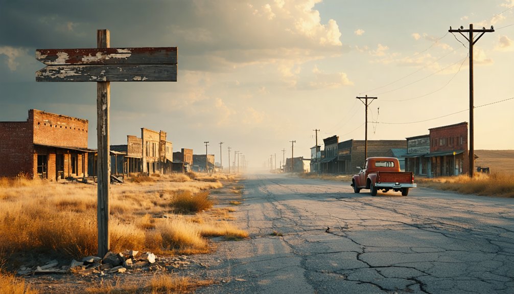
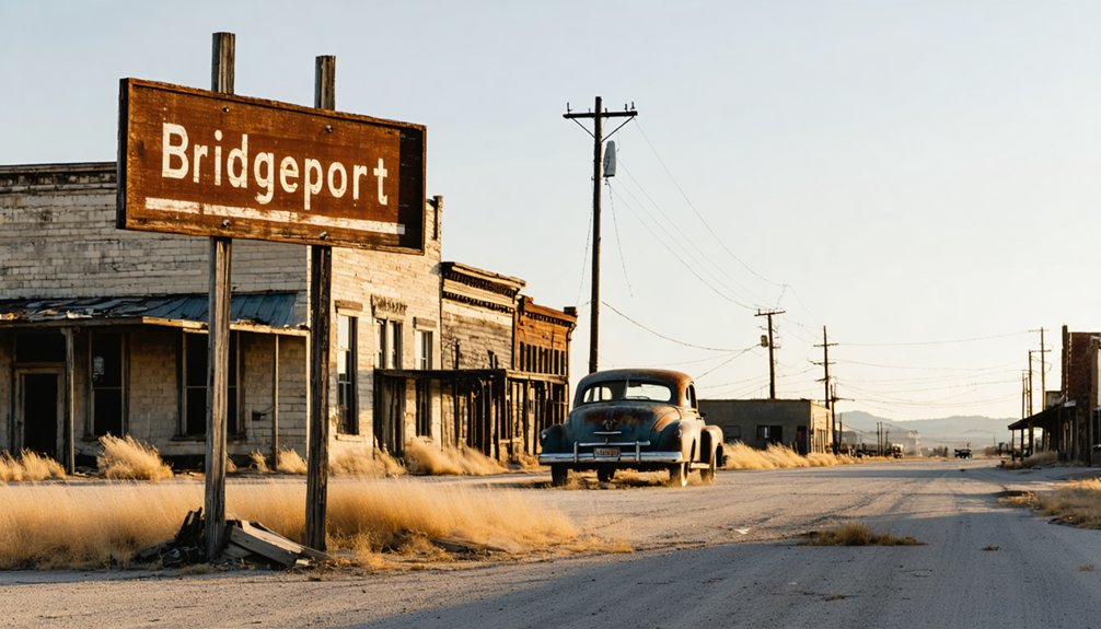
You’ll discover Bridgeport’s haunting remains along Route 66, where the iconic 3,900-foot Pony Bridge—featured in *The Grapes of Wrath*—still spans the Canadian River. Navigate to this ghost town via Highway 281, where you’ll find the weathered post office and skeletal bus depot ruins whispering tales of Bonnie and Clyde’s alleged visits. The restored yellow bridge trusses stand as monuments to Depression-era resilience, while abandoned storefronts reveal how highway realignment transformed prosperity into prairie silence. Beyond these structures lie deeper stories of betrayal and vanished dreams.
Key Takeaways
- Bridgeport sits on historic Route 66, accessible via the 3,900-foot Pony Bridge featured in John Ford’s 1940 film The Grapes of Wrath.
- Visit the abandoned post office and skeletal bus depot ruins, rumored stop of Bonnie and Clyde during the 1930s.
- The town’s population declined from 3,000 to 30 after Route 66 realignment bypassed it in 1933.
- Explore the restored yellow steel trusses of the Canadian River Pony Bridge, the longest Route 66 structure of its kind.
- Bridgeport’s remaining structures offer tangible connections to Route 66’s golden era and westward migration during the Great Depression.
The Rise and Fall of a Strategic River Crossing Town
Long before settlers staked their claims across the windswept Oklahoma plains, Native American tribes recognized the Canadian River’s shallow crossing as a natural highway between territories. When Congress opened 3.5 million acres in 1892, this strategic ford became the foundation for rural community development in 1895.
You’ll find Bridgeport’s story mirrors countless frontier dreams—the 1901 federal townsite thrived when the Choctaw Railroad arrived, connecting isolated homesteaders to distant markets. However, the town’s refusal to pay railway insurance doomed its prosperity, sending residents fleeing to neighboring communities with better connections.
Despite a second railway in 1902, Bridgeport never recovered its momentum. The harsh 1885-1896 drought had already demonstrated the region’s agricultural relevance depended entirely on rail access—without it, settlers couldn’t ship crops, and dreams withered like unwatered wheat.
How Route 66 Shaped Bridgeport’s Destiny
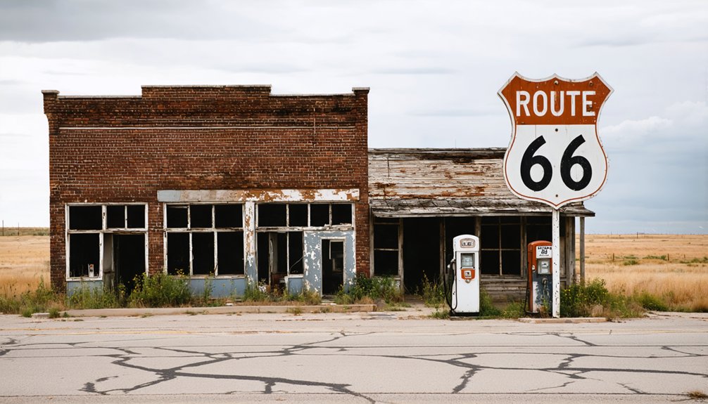
The railway’s rejection sealed Bridgeport’s fate, but salvation appeared in 1926 when federal highway planners routed their ambitious new transcontinental artery—Route 66—directly through town. You’ll discover how the Mother Road transformed this cotton-farming community into a bustling stopover, with twenty-five commercial enterprises thriving by the mid-1930s. The iconic 1933 William H. Murray Bridge—spanning nearly 4,000 feet across the unpredictable Canadian River—became Oklahoma’s engineering marvel and your gateway to westward adventure.
But freedom cuts both ways. That same year, highway realignment bypassed Bridgeport entirely, creating a shifting economic landscape that strangled the town’s lifeblood. Residents fled to communities along the new route, chasing lost opportunities for revitalization. Route 66 giveth, and Route 66 taketh away.
Exploring the Remaining Ghost Town Structures
As you walk along the east side of Market Street between Wichita Avenue and Broadway, the abandoned post office emerges from the overgrown landscape—a weathered sentinel of Bridgeport’s vanished Main Street era.
Just south of the bridge at Hinton Junction, the skeletal walls of the former bus depot still stand, their crumbling concrete maintained out of pure sentiment for the building’s rumored connection to Bonnie and Clyde’s gas station stops.
These structures, though beyond salvation, offer tangible touchstones to the town’s Route 66 heyday, their decay telling stories that faded photographs cannot.
Historic Post Office Building
Standing on higher ground along the east side of Market Street, the historic post office building looms as a skeletal reminder of Bridgeport’s contentious past. This simple tin-roofed structure witnessed the infamous town feud when west side businessmen secretly moved the depot at night, triggering an exodus of merchants to Hinton in 1902.
The weathered architecture reveals decades of neglect—collapsing elements that photographers documented between 2019 and 2021 mark its slow demise.
You’ll find it positioned between Wichita Avenue and West Broadway, accessible via the old main street north off Route 66. Its architectural significance lies in surviving what others couldn’t: the 1934 highway realignment, devastating Canadian River floods, and Route 66’s decommissioning.
Today, it stands forlorn—one of few tangible remnants in this ghost town where population plummeted from 3,000 to thirty.
Abandoned Bus Depot Ruins
Beyond the crumbling post office, you’ll discover the abandoned bus depot ruins clinging to existence along Bridgeport’s old main street. These vanishing structural features once served travelers during Route 66’s golden era, when this crossing point bustled with cafes and tourist courts.
The depot’s story traces back even further—originally a gas station where Bonnie and Clyde allegedly stopped, charming the owner’s grandmother with their presence.
Today, tin-roofed walls stand protected but decaying, their fate of depot walls secured by a resident determined to preserve this fragment of history. Though structurally stable with maintenance, the shell represents decades of abandonment following Canadian River floods and Interstate 40’s construction. You’ll find belongings left behind, their chilling presence evoking the exodus that transformed this once-thriving waypoint into silent testimony.
The Historic Canadian River Pony Bridge Experience
As you approach the Canadian River, the 3,900-foot Pony Bridge stretches before you—the longest structure of its kind along the entire Route 66 corridor. This steel truss span, known locally as Bridgeport Bridge, carried desperate Dust Bowl families westward in the 1930s and earned its place in American cinema when director John Ford filmed it for *The Grapes of Wrath* in 1940.
Stand where Tom Joad’s fictional journey crossed into reality, and you’ll feel the weight of history beneath your feet on this National Register landmark.
Engineering Marvel and Length
The Canadian River Bridge stretches out before you like a massive steel spine across the restless riverbed—3,944 feet of continuous pony truss spans that earned it the title of America’s longest pony truss bridge. You’re looking at the engineering significance of Depression-era ingenuity, where 38 camelback trusses march across the unpredictable South Canadian River in perfect 100-foot intervals.
Built during the Dust Bowl, this wasn’t just ambitious—the Oklahoma Highway Commission called it their most pretentious project. You’ll appreciate why when you consider the challenge: spanning nearly three-quarters of a mile across shifting sand and water channels that routinely swallowed lesser structures.
The freshly rehabilitated yellow spans maintain the original 1934 design, proving that smart engineering transcends eras. It’s raw Route 66 freedom, preserved.
Grapes of Wrath Connection
When Henry Fonda’s battered jalopy rolled across this very bridge in *The Grapes of Wrath*, Hollywood captured what thousands of real Oklahoma families had already experienced—the desperate westward exodus from dust-choked farmland to California’s promised orchards. That 1940 film scene transformed the Pony Bridge into something beyond infrastructure—it became a monument to American resilience and the raw determination to break free from circumstance.
Standing where Fonda stood, you’ll grasp the bridge’s cultural significance as both Route 66 landmark and Depression-era symbol. The film industry legacy cemented this crossing’s place in America’s collective memory, forever linking it to westward migration and the pursuit of better lives. Today, the restored yellow steel trusses honor those who refused to surrender their dreams to dust storms and economic collapse.
Legendary Visitors and Untold Stories From Bridgeport’s Past
Legends of infamous outlaws cling to Bridgeport’s dusty streets like tumbleweeds against a weathered fence post. You’ll hear whispers of Bonnie and Clyde stopping at a gas station—now the old bus depot—where Bonnie supposedly handed candy to a local family. The current owner preserves the building, honoring this romanticized chapter passed down through generations.
While local legend embellishments blur fact from fiction, they reveal something deeper: Bridgeport’s hunger for glory amidst decline. The same town that witnessed tangled political rivalries—businesses fleeing east to west, a post office stolen by night, bitter water feuds—craved larger-than-life stories. Whether those notorious outlaws truly paused here matters less than why people needed to believe they did. These tales became Bridgeport’s defiant answer to obsolescence.
Finding Bridgeport requires deliberate intent—this ghost town won’t reveal itself from the interstate’s hurried lanes. You’ll need to exit I-40 at Exit 101, two miles east of town, then navigate back along the original 1926-1934 Route 66 alignment. The interstate runs just half a mile south, yet Bridgeport remains hidden from modern traffic that bypassed it in 1958.
Your navigation options include approaching from Hinton Junction, one mile east, or following the concrete-surfaced section from Hydro to the west. The old suspension bridge marks your eastern entrance, while interstate access routes connect you to El Reno eastward or Weatherford westward. Watch for the turn north off the highway—Bridgeport’s main street leads to the church, cemetery, and decaying post office awaiting your discovery.
What to See on Your Visit to Bridgeport Today
Though Bridgeport’s streets now stand silent, the town’s skeletal remains tell vivid stories of Route 66’s golden era. You’ll discover the 3,944-foot Canadian River Bridge—Oklahoma’s longest steel-truss span on the Mother Road—now rusting peacefully in bypassed countryside.
The old bus depot ruins showcase local community preservation efforts, where an owner lives on-site in a trailer, maintaining walls his grandmother knew when Bonnie and Clyde stopped through. Hunt for memorable architectural details at the abandoned post office‘s tin-roofed simplicity and the historic “house and canopy” gas station with its 1934 well house.
Scattered foundations, overgrown lots, and a quiet cemetery complete your exploration. You’re free to wander these authenticated remnants without crowds or restrictions.
Safety Considerations and Visitor Guidelines
Before you venture into Bridgeport’s atmospheric ruins, you’ll need to prepare for the realities of exploring an abandoned settlement along Oklahoma’s rural Route 66 corridor. Wear sturdy boots and light-colored clothing with a safety vest when near roadways. Pack wilderness first aid supplies, sunscreen, and ample water—cell service won’t reach you here.
As you navigate through the area, keep an eye out for abandoned buildings in Omega, Oklahoma, which tell stories of a bygone era. These structures may resemble ghostly sentinels of the past, and exploring them can unveil a rich tapestry of history. Remember to take pictures but always prioritize safety, as some sites may be unstable.
Wildlife encounters demand caution: avoid tall grass concealing snakes and stinging insects, and never handle discarded needles. The ghost town’s overgrown pathways hide hazardous foundations and unstable structures marked with keep-out signs—respect these warnings. Monitor weather conditions before departure, as rural areas lack emergency alerts. Inform someone of your itinerary and plan fuel stops in El Reno or Weatherford.
Drive cautiously on Route 66’s original Portland cement segments, watching for potholes and sharp curves.
Frequently Asked Questions
Are There Any Nearby Accommodations or Camping Options for Overnight Stays?
You’ll find Territory Route 66 RV campground right in Bridgeport, while nearby El Reno and Weatherford offer bed and breakfast options plus modern hotels. Coincidentally, these same towns serve those famous onion burgers you’ve been craving during your freedom-seeking adventure.
What Is the Best Time of Year to Visit Bridgeport?
You’ll find the best visiting conditions during spring when wildflowers blanket the prairie, or choose ideal autumn weather in September-October. Both seasons offer comfortable temperatures and clear skies, perfect for exploring Bridgeport’s abandoned structures without extreme heat or cold.
Are There Restaurants or Stores Near Bridgeport for Supplies?
Bridgeport itself offers no grocery stores, gas stations, or restaurants—it’s a genuine ghost town. You’ll find supplies, fuel, and famous onion burgers in El Reno eastward, or diners and amenities in Weatherford westward along Route 66.
Can I Explore Inside the Abandoned Buildings or Are They Off-Limits?
You can’t legally explore inside abandoned buildings without permission—they’re privately owned and off-limits. Trespassing carries potential legal concerns including fines or arrest. Stick to external photography from public roads to respect property rights and stay safe.
How Much Time Should I Plan for a Complete Visit?
Before you swipe to your next destination, plan a 2-3 hour tour length for Bridgeport’s complete experience. Your visitation duration covers the bridge, cafe ruins, cemetery, and that stunning 19.5-mile Route 66 stretch—unhurried freedom.


