You’ll find Bryant at coordinates 26°50′59″N 80°36′59″W, accessible via State Road 700 northeast of Pahokee or through Old Connor Road’s 1.8-mile gravel approach. Bring sturdy boots to navigate crumbling pavement where stop signs still stand guard over intersections no car has crossed since 2007. The rusted sugar mill skeleton rises above Everglades vegetation thick enough to swallow the fifty former house sites whose foundations now hide beneath wild growth, and there’s considerably more to uncover about this vanished community.
Key Takeaways
- Bryant is located at coordinates 26°50′59″N 80°36′59″W, accessible via State Road 700 northeast of Pahokee or US Highway 98.
- Roads to Bryant are poorly maintained with crumbling pavement and overgrown vegetation, requiring sturdy boots for exploration.
- The main attractions include the US Sugar commissary facility, memorial plaque, and rusted industrial ruins of the former sugar mill.
- Approximately 50 former house sites remain visible along a grid of abandoned streets still marked by faded street signs.
- Old Connor Road offers an alternate access point requiring a 1.8-mile approach via gravel track to reach the ruins.
The History Behind Bryant’s Rise and Fall
The story of Bryant begins with an ambitious Englishman who saw opportunity in Florida’s untamed Everglades. F.E. Bryant arrived in 1894, and after studying agriculture and running dairies out West, he set his sights on Florida’s frontier in 1908.
The Bryant family agricultural innovators purchased vast Everglades tracts, and through Palm Beach Farms Company development, they transformed wilderness into thriving communities like Lake Worth and Greenacres.
Through vision and determination, the Bryants carved civilization from swampland, establishing Palm Beach Farms Company and founding communities that endure today.
When WWI created sugar shortages, Bryant seized another opportunity. He built the county’s first sugar mill in 1921 near Pahokee, naming it “Azucar.” Despite floods and hurricanes devastating the region, including 1928’s catastrophic storm that killed 3,000, the operation persisted.
After Bryant’s death in 1946, the renamed town peaked with 1962’s massive mill before closing in 2007, leaving behind empty streets and silent machinery.
What to Expect at This Abandoned Sugar Town
Today’s Bryant exists only as whispers of its industrial past, reclaimed by the very Everglades that F.E. Bryant once conquered. You’ll find overgrown ruins where the world’s largest sugar mill once dominated the horizon—demolished by 2016, leaving only the commissary facility standing sentinel.
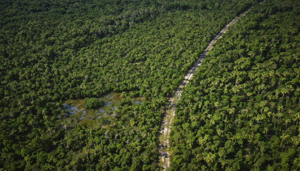
The roads that served thousands of workers are barely walkable, consumed by hidden wildlife and diverse natural scenery at 13 feet above sea level.
Navigate to coordinates 26°50′59″N 80°36′59″W via State Road 700, 3.5 miles northeast of Pahokee. Google Maps still displays street names over satellite views of nothing. You’re exploring genuine abandonment here—crumbling foundations, rusted remnants, and nature’s patient victory over industrial ambition.
Pack water, wear boots, and embrace the solitude of Florida’s forgotten company town.
Getting to Bryant: Directions and Access Points
You’ll find Bryant along US 98, about a mile east of Canal Point, where Old Connor Road marks your turnoff into this forgotten sugar town.
The drive requires only a standard 2WD vehicle, though you’ll navigate a grid of crumbling streets that were barely walkable by 2013, their pavement surrendering to weeds and palmetto scrub.
Pull up Google Maps before you go—the satellite view still shows street names and stop signs standing guard over empty lots where fifty houses once stood.
Primary Route via US 98
Winding through Florida’s forgotten Panhandle, US Highway 98 serves as your gateway to Bryant’s abandoned remains, a ribbon of asphalt that parallels the Gulf Coast before cutting inland through pine forests and sleepy crossroads.
You’ll find ghost town access requires patience and sharp eyes—Bryant doesn’t announce itself with signs. Old route conditions demand attention: weathered pavement gives way to sand-dusted shoulders where civilization thins.
As you venture deeper into the heart of the state, you’ll discover some of the most picturesque road trip destinations in Florida. From the tranquil beaches of the Emerald Coast to the lush landscapes of the Big Cypress National Preserve, each stop offers a unique glimpse into the natural beauty that defines the Sunshine State. Embrace the journey, and let the winding roads lead you to hidden gems and unforgettable experiences.
Watch for the faded county road intersection roughly fifteen miles past established markers, where locals rarely venture. Your vehicle should handle unpaved surfaces, as the final approach trades smooth asphalt for rutted dirt.
Mobile reception fades here, so download offline maps beforehand. The isolation that claimed Bryant’s essence now grants you unfiltered exploration—exactly what you’re seeking beyond tourist traps and manicured destinations.
Old Connor Road Turnoff
Between the palmetto thickets and forgotten rail corridors, Old Connor Road emerges like a scar across Florida’s interior—a dust-choked passage that refuses to fade completely into wilderness.
You’ll find the turnoff 2.5 miles east of Indiantown at 27°09’15″N 80°51’00″W, marked by weathered historical markers barely visible through scrub.
Branch off CR-714 onto the gravel track—four-wheel drive essential for the 1.8-mile approach. I’ve walked this route when my truck couldn’t handle August mud; the trek passes a rusted 1920s trestle and Connor family cemetery before reaching lost citrus groves that signal Bryant’s edge.
Pack a satellite communicator—cell service dies within half a mile. Gators patrol the wetland crossings, and those seasonal gates slam shut June through October.
Road Conditions and Accessibility
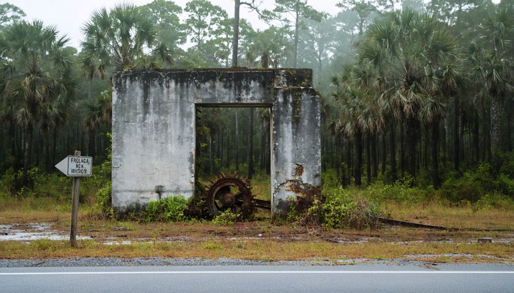
Finding Bryant requires traversing a landscape the sugar industry left behind like peeling wallpaper. You’ll approach via State Road 700, watching for the turnoff near US 98/441 on Lake Okeechobee’s eastern shore. The roads aren’t what they were—by 2013, explorers reported paths barely walkable, consumed by impassable vegetation reclaiming what humans abandoned. You’re maneuvering through overgrown ruins where street signs still stand like tombstones marking a demolished town.
The mill’s fenced perimeter remains visible northbound on FL 700, but don’t expect maintained access. This abandoned infrastructure tells its own story through cracked pavement and tangled undergrowth. Google Maps satellite view shows the ghost grid, though what you’ll find on the ground depends on nature’s mood. Bring sturdy boots. The former Everglades doesn’t forgive soft soles.
The US Sugar Commissary and Factory Ruins
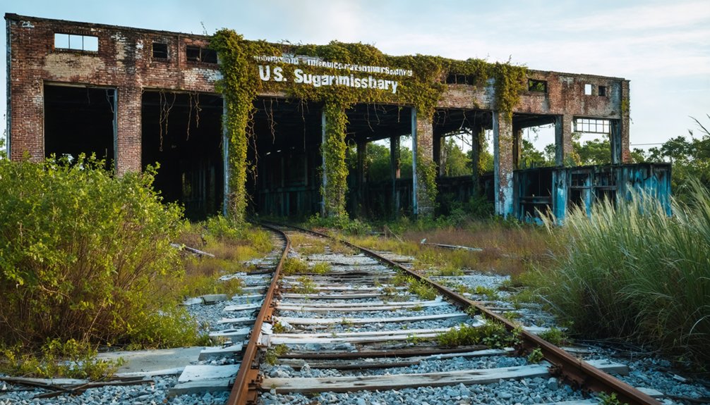
Standing amid overgrown palmetto scrub, the skeletal remains of Bryant’s sugar mill rise against the Florida sky like a rusted industrial cathedral. You’ll find these weathered structures where the world’s largest sugarcane processing plant once churned through 5,000 tons daily.
Where giants of industry once dominated the landscape, nature and decay now wage their own slow battle for supremacy.
The commissary facility stands sentinel beside the mill ruins—remnants of a vanished community that thrived until 2007.
Walk carefully around these industrial bones. The mechanical harvesters that displaced workers in the early ’90s are long gone, but you can still trace the operational footprint. A memorial plaque marks where founder Frederick E. Bryant’s legacy began.
These ruins connect directly to Everglades sugar production history, preserved through land sales supporting the River of Grass Restoration Project. They’re yours to explore—uncrowded, unpolished, authentic.
Exploring the Empty Streets and Remaining Signs
Walking Bryant’s abandoned streets feels like traversing a suburban neighborhood frozen in time—stop signs and speed limit markers still command intersections where no cars have driven in decades. You’ll spot street signs poking through chest-high weeds, their faded names marking a grid of 25 to 50-foot residential lots now buried beneath Everglades vegetation.
The crumbling asphalt beneath your feet connects roughly 50 former house sites, their concrete foundations barely visible through the overgrowth that’s reclaimed what was once a functioning company town.
Street Signs Without Residents
The street signs of Bryant tell a story in reverse—instead of marking a living community, they stand sentinel over absence. You’ll encounter stop signs commanding traffic that doesn’t exist, speed limits enforced on roads where nobody drives. This symbolism of lingering street signs creates an unsettling contrast—official warnings and directions for a population that vanished in 2007 when US Sugar closed the mill.
Pull over anywhere along the grid and listen to the eerie silence of empty grid stretching before you. From your vehicle, count roughly 50 spots where houses once sheltered families. The US Sugar Commissary looms nearby, a concrete reminder that 200 jobs once anchored this place. These signs weren’t removed because there’s no reason to—nobody’s coming back.
Overgrown Roads and Foundations
As you venture deeper into Bryant’s ghost town grid, nature’s aggressive reclamation becomes immediately apparent. The asphalt roads you’ll navigate have degraded into dirt-like surfaces, barely distinguishable from the surrounding Everglades vegetation.
Since the 2007 mill closure, Florida’s relentless flora has consumed what were once clearly defined streets, now requiring deliberate navigation through weed-choked pathways.
Your 2WD vehicle can handle these rudimentary routes, though visibility challenges demand careful attention. The fading infrastructure reveals approximately 50 former house sites—concrete foundations hidden beneath thick weeds, visible only on satellite imagery.
This ecological integration is complete: where families once lived, you’ll find empty lots between the surviving mill and commissary structures. The hot, buggy climate accelerates this transformation, erasing Bryant’s urban footprint season by season.
Driving slowly along Old Conner Road off US98, you’ll encounter one of Florida’s strangest roadway experiences—fully intact street signs governing a neighborhood that no longer exists. Stop signs command empty intersections. Speed limits regulate streets where nobody drives. This grid geometry stretches approximately one mile east of Canal Point, its blueprint from 1912 still dictating the landscape’s skeleton.
Your 2WD vehicle handles these abandoned roads fine, though summer brings oppressive heat and mosquitoes. The street signage remnants create an eerie regulatory framework for ghost residents—formal order imposed on vacancy. You’re free to explore roughly 50 locations where homes once stood, visible on Google Earth beforehand. The US Sugar Commissary structure stands among these surreal markers, a memorial to the mill workers who departed in 2007.
Best Time of Year to Visit Bryant
Timing your visit to Bryant depends entirely on what kind of ghost town experience you’re chasing.
The best months to visit Bryant fall into three distinct categories:
- Winter solitude (December-February) – Cool, crisp mornings and empty landscapes create an authentically eerie atmosphere. You’ll have crumbling structures entirely to yourself, with temperatures in the comfortable 60s-70s range.
- Spring exploration (March-May) – The ideal season for exploring arrives with mild 70s-80s°F weather, perfect for extended photography sessions and wandering overgrown paths without summer’s brutal humidity.
- Fall adventure (September-November) – Fewer crowds and softer light make October exceptional for capturing atmospheric shots, though you’ll need to monitor hurricane forecasts.
Avoid summer’s oppressive heat unless you’re committed to sunrise-only exploration.
What You Can Still See Using Google Earth
When you pull up Bryant on Google Earth, the town’s bones are still there—a clear grid of streets with stop signs frozen in time, about fifty dark spots where houses once stood, and the hulking US Sugar Commissary building rising from the overgrowth.
You’ll trace Bryant Avenue intersecting with Hanover Circle and follow the faint outline of Guava Lane as it disappears into what’s now reclaimed Everglades. The closed sugar mill buildings dominate the satellite view, fenced and intact since 2007, standing as the last monuments to the 200 jobs that vanished when the factory shut down.
Street Layout And Grid
Though Bryant’s houses vanished years ago, the skeleton of this company town remains remarkably intact from above. Google Earth reveals the complete grid layout stretching across former Everglades land, with road signage still marking intersections nobody travels.
You’ll spot three main arteries:
- Bryant Avenue – The primary thoroughfare with its street sign buried in overgrowth
- Hanover Circle – Curves through what were residential blocks
- Guava Lane – Cuts across the southern section
Stop signs and speed limits stand guard over empty pavement, frozen sentinels from the 1950s when US Sugar built this community. The satellite view shows asphalt ribbons deteriorating since 2007’s mill closure, barely walkable but undeniably present. This grid earned a “4” rating in ghost town documentation—visible, accessible, and hauntingly preserved by nature’s slow reclamation.
Fifty House Foundation Spots
Beyond those empty streets lies an even stranger sight: fifty ghostly rectangles where families once lived. You’ll spot them best through satellite imagery mapping on Google Earth—weed-covered pads clustered along the grid where US Sugar workers raised their kids from the 1950s until 2007. This foundation archaeology tells Bryant’s story better than any historical marker could.
Each concrete outline marks where approximately 200 families built their lives around mill shifts and paychecks. The Everglades is swallowing them fast, but you can still distinguish these evenly-spaced remnants from surrounding scrub. They’re uniform, deliberate—classic company town planning now surrendering to nature’s timeline.
Drive there and you’ll barely see them through the overgrowth. But zoom in from above, and fifty silent testimonies reveal themselves—proof that freedom sometimes means leaving everything behind.
Mill And Commissary Buildings
Toggle between seasonal images for best clarity—summer heat burns back foliage, revealing more. These monuments to forgotten industry stand where 200 workers once earned paychecks, now reclaimed by Everglades wilderness they briefly conquered.
F.E. Bryant and the Pioneer Sugar Industry Legacy
When Englishman F.E. Bryant first surveyed South Florida’s Everglades in 1909, he saw potential where others saw swampland. You’re standing on ground where pioneering sugarcane cultivation transformed America’s agricultural landscape.
Bryant didn’t just farm—he built the infrastructure, lobbying for the experimental field station at Canal Point in 1920 that still operates today.
His “Azucar” plantation represented more than crops; it embodied farming community history through a vision of workers’ housing and sustainable living. Despite devastating floods in 1922 and 1924, he persisted until his death in 1946.
When Charles Stewart Mott‘s U.S. Sugar Corporation honored him by renaming Azucar to “Bryant,” they acknowledged the man who proved sugar could thrive in Florida’s challenging terrain. His memorial plaque tells it straight: he started it all.
Safety Tips for Exploring Overgrown Ghost Town Sites
Bryant’s sugar legacy may have vanished beneath Florida’s reclaiming vegetation, but the ruins remain—and they’re treacherous. Before venturing into these overgrown remnants, you’ll need proper preparation:
- Assemble your crew wisely – Never explore alone. Three minimum means someone stays with injured parties while another fetches help. Share your location with someone staying behind.
- Pack protection essentials – Sturdy boots, thick gloves, FFP3 masks for mold exposure, and multiple flashlights aren’t optional. Equipment maintenance matters when you’re miles from civilization.
- Watch for collapse zones – Test every surface before trusting your weight. Florida’s humidity accelerates rot—wooden structures and stairs deteriorate faster here.
Practice personal health monitoring throughout: dizziness signals dangerous mold exposure. Trust your instincts and retreat when conditions deteriorate.
Other Abandoned Towns in the Glades Region Worth Visiting
Beyond Bryant’s crumbling foundations, the Glades region conceals a constellation of forgotten settlements—each one silenced by the same catastrophic forces that shaped Florida’s swampy interior.
You’ll find Okeelanta where US Route 27 meets County Route 827, its sugar refining facility standing sentinel over vanished streets. The 1928 hurricane erased Bean City and Ritta Island completely—no rebuilding, just wildlife within the abandoned town footprints.
Citrus Center sits empty near coordinates 26°51.1’N, accessible via old sugarcane transportation routes that once fueled the region’s economy.
Most intriguing? Glades Correctional Institution‘s fenced ghost town between Belle Glade and Pahokee. Mid-century structures from the 1932 prison farm decay behind chain-link—a surreal time capsule you can photograph from outside. Each site offers unfiltered glimpses into Florida’s untamed past.
Frequently Asked Questions
Are There Any Entrance Fees or Permits Required to Visit Bryant?
No entrance fees are documented, but you’ll want to research private property considerations before exploring. Since historical preservation concerns protect ghost towns, you should verify current access rights and respect any posted boundaries during your adventure.
Can I Enter the Remaining Factory Buildings and Commissary Structure?
No official access exists—you’d face trespassing risks on private property. The deteriorating structures present potential structural dangers with crumbling floors and unstable walls. It’s best to admire Bryant’s haunting silhouette from the roadside for your safety.
What Specific Gear Should I Bring for Exploring the Overgrown Areas?
You’ll need sturdy hiking boots to navigate tangled vines and hidden debris, plus thick protective gloves to push through thorny brush. Don’t forget long sleeves, a machete for dense vegetation, and tick repellent—trust me, you’ll thank yourself later.
Are There Any Nearby Facilities for Food, Water, or Restrooms?
No public facilities are available at Bryant—you’ll find no food, water, or restrooms. Bring everything you need. Despite potential restoration plans being discussed, this ghost town remains wild, remote, and completely undeveloped for visitors.
Is It Legal to Take Artifacts or Items Found Among the Ruins?
No, it’s illegal. You’ll face misdemeanor or felony charges since ownership claims belong to US Sugar Corporation. Beyond legal risks, environmental preservation matters—leave artifacts untouched. Photograph memories instead; they’re yours to keep without consequences.