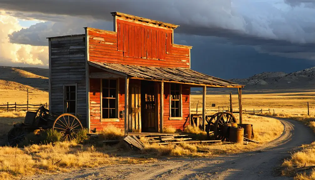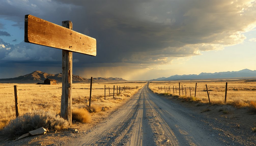
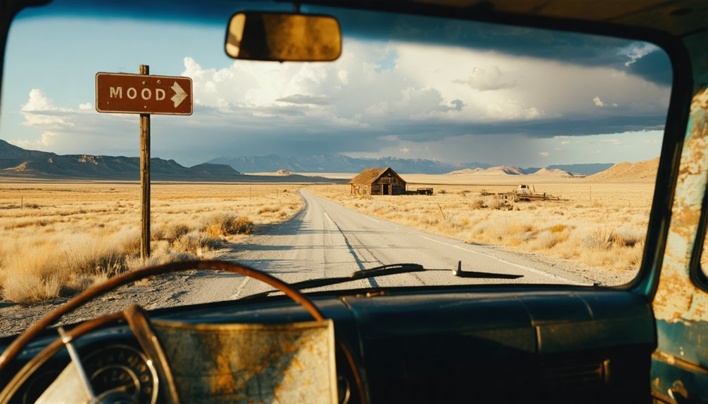
You’ll need a high-clearance vehicle and a full tank of gas to reach Buckhorn, located 10 miles from Newcastle on weathered gravel roads. Plan your visit between mid-June and October—spring mud and winter snows make access impossible. Once there, you’ll explore three intact beehive charcoal kilns, scattered ore carts, and a 1940s flatbed truck abandoned mid-repair. The remote site requires self-navigation using Soldier Creek as your primary landmark, though the backcountry rewards prepared adventurers with unguided access to Wyoming’s authentic mining past.
Key Takeaways
- Visit between mid-June and October; winter snows close backcountry access and spring melt creates impassable muddy conditions.
- Bring a high-clearance vehicle for weathered gravel roads and fuel up in Newcastle, the last service stop.
- Explore three intact beehive charcoal kilns, crumbling building foundations, and scattered mining equipment without admission fees.
- Use Soldier Creek as your navigation marker; dirt roads trace its banks toward the ghost town site.
- Expect open prairie with uneven terrain, sagebrush steppe, and unobstructed views across the windswept landscape.
Getting to Buckhorn: Routes and Seasonal Access
Nestled in the remote corners of Weston County, Buckhorn sits roughly ten miles from Newcastle, Wyoming, accessible primarily through a network of weathered gravel roads that peel off from the main county routes. You’ll want a high-clearance vehicle for the final push—these aren’t manicured paths. The gravel road conditions shift with weather; spring melt turns them to soup, while summer bakes them hard and dusty.
Fuel stop requirements are critical here. Fill up in Newcastle before venturing out—there’s nothing but sagebrush and history beyond town limits. Plan your visit between mid-June and October when conditions favor exploration. Winter snows lock the backcountry tight, and you don’t want to test Wyoming’s isolation unprepared. Topographic maps aren’t optional; they’re your lifeline.
The Rise and Fall of a Mining Boomtown
A frigid winter in 1908-09 changed everything for this windswept corner of Weston County when prospectors pulled gold from Buckhorn Ridge. You’ll find the mining legacy written in abandoned tunnels and rusted equipment—1,600 feet of underground passages carved by 1906, followed by a mill that processed 195,000 tonnes of ore.
The town’s golden years peaked between 1914-1916 when the cyanide plant produced over a tonne of gold.
But local folklore tells the brutal truth: exhausted veins and encountered “horses”—barren rock masses—killed operations by 1937. Revival attempts failed repeatedly through 1984, when production costs hit $200 per ounce. Today, you’re walking through what determination built and geology destroyed.
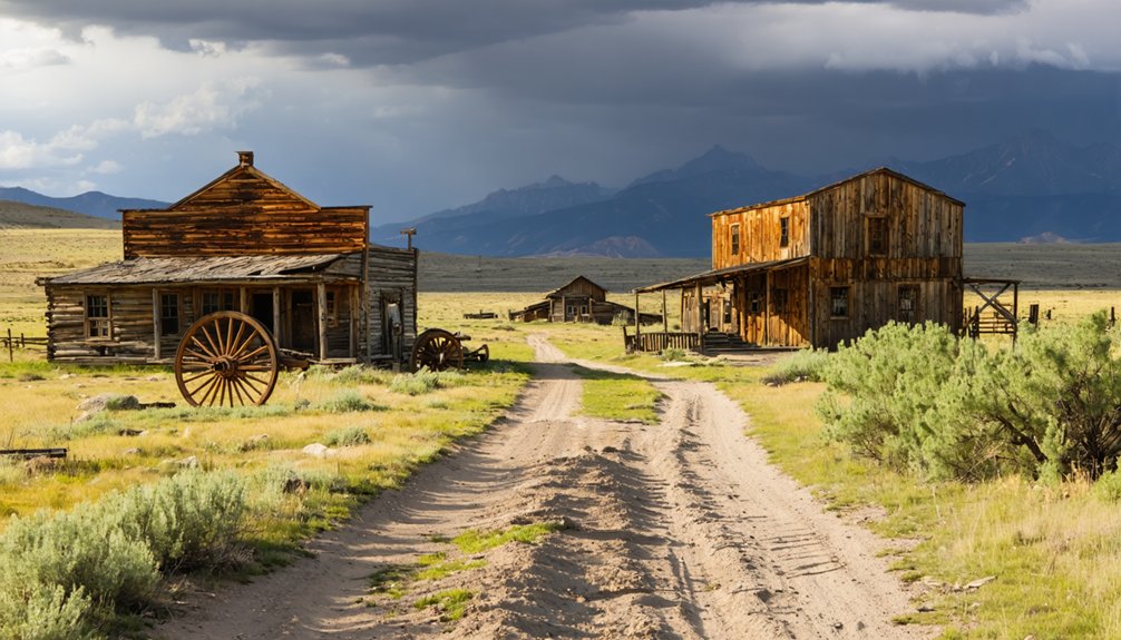
What Remains: Exploring the Four Standing Structures
Beyond the rusted mining equipment and collapsed foundations, Buckhorn’s most impressive survivors are its beehive-shaped charcoal kilns—three standing intact with the partial remains of a fourth. You’ll notice the blackened interiors immediately—evidence of intense charcoal production that once fueled regional smelters. The architectural significance of structures like these can’t be overstated; they’re masterworks of industrial limestone construction, likely quarried near Fort Bridger.
One kiln collapsed before Wyoming acquired the site, but state preservation efforts now protect what’s left. Walk the upgraded path circling these monuments, and you’ll spot remnants of the town’s former amenities—pool hall, school, company store locations marked by crumbling foundations. The charred mortar tells stories of continuous operation, when this remote outpost thrived on railroad-driven commerce and mountain freedom.
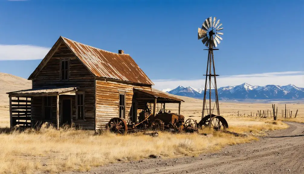
Relics of Industry: Mining Equipment and Vintage Vehicles
Scattered across Buckhorn’s sagebrush-dotted landscape, rusted mining relics tell stories of backbreaking labor and ambitious extraction. You’ll discover corroded ore carts half-buried in Wyoming soil, their wheels frozen in time. Weathered winches and cable spools stand as monuments to the miners who worked this unforgiving terrain.
The vintage truck preservation here exists in raw, unrestored form—no museum glass between you and history. A 1940s-era flatbed sits where it died, its hood gaping open like a metallic mouth.
The mining artifacts display spreads organically across the valley, each piece positioned exactly where workers abandoned it. You’re free to explore these industrial remnants without guided tours or admission fees. Touch the sun-warmed metal, photograph the decay, and connect directly with Wyoming’s untamed past.
You’ll find Soldier Creek cutting through the landscape as your primary navigation marker—follow the dirt roads that trace its wooded banks through eastern Wyoming’s backcountry.
The open prairie stretches wide around Buckhorn, offering unobstructed views but also uneven ground that’ll test your boots and your vehicle’s suspension.
If you’re approaching from higher elevations, the canyon route drops through stands of pines, their shade a brief respite before you emerge onto the stark, windswept flats where the ghost town sits.
The Soldier Creek road winds four miles west of Sheridan before delivering you to the trailhead, where 5.3 miles of raw Wyoming backcountry await. You’ll need landowner permission before starting—this isn’t public land.
The trail follows PK Lane upward through open prairie ringed by Quaken Asp, where trail conditions shift dramatically with deep powder snow pockets that’ll test your resolve. Keep your eyes sharp for wildlife sightings among the scattered relics of old cars and trucks dotting the route.
As you climb through the Bighorn Foothills, mountain vistas expand before you. The path crosses private and leased lands, passing near Buckhorn’s ghost town outskirts. Those abandoned structures with their rusting snowmobiles aren’t just scenery—they’re freedom’s weathered monuments.
Open Prairie Landscape Features
Beyond the trailhead, rolling hills surge across the northeastern Wyoming horizon like frozen waves, their dusty backs climbing from 3,500 to 5,000 feet in gradual swells. You’ll navigate sprawling ranchlands exceeding 5,000 acres each, where weathered barns punctuate sagebrush steppe that stretches unbroken for miles.
This semiarid terrain supports remarkable wildlife herds—elk numbering up to 100 grazing freely, pronghorn antelope blazing across the prairie, and mule deer browsing sagebrush that comprises a third of their winter diet. Watch for coyotes, foxes, and jackrabbits threading through wildflower patches and cactus clusters.
The vast skies here dwarf everything beneath them, especially during golden hour when light transforms the hills into dramatic silhouettes. It’s untamed country where you’re truly alone with the landscape.
Canyon Route Through Pines
Leaving the open prairie behind, your route plunges into Shell Canyon where red rocky walls rise like ancient sentinels along the winding road. Juniper covered switchbacks climb toward the Bighorn Mountains as ponderosa pines mingle with Douglas fir and aspen. Watch for Rocky Mountain bluebirds darting between boulders tumbled beside Shell Creek below.
The 120-foot Shell Falls rewards your ascent—locals call it the “Thundering Heartbeat of the Bighorn Mountains.” Stop at the interpretive site’s boardwalk for close-up views of water carving through Precambrian granite. Seasonal wildflower blooms splash color across the canyon floor from mid-May through September.
Beyond the falls, guardrails guide you through upper switchbacks toward Granite Pass, where massive limestone cliffs tower overhead and the promise of Buckhorn’s ghost town awaits in high country.
Best Times to Visit This Remote Ghost Town
When planning your journey to Buckhorn, you’ll want to aim for late spring through early fall—roughly May through October—when county roads remain passable and the high-altitude terrain shakes off its winter snow. Understanding seasonal weather patterns helps you maximize your adventure through these ideal visitation windows.
Your best timing options:
- Late Spring (May-June): Wildflowers carpet the meadows while snow still crowns distant peaks—bring your high-clearance 4×4 as lingering drifts may block certain routes.
- Summer (July-August): Expect comfortable 78-degree days perfect for exploring crumbling cabins, though wildfire smoke occasionally drifts through prairie valleys.
- Early Fall (September-October): Cooler temperatures mean fewer crowds and spectacular golden aspens framing weathered structures—you’ll practically have the ghost town to yourself.
Winter transforms Buckhorn into snowmobile-only territory for hardcore backcountry enthusiasts.
The McInernie Homestead: A Nearby Historical Gem
Just three miles from Buckhorn’s weathered storefronts stands the McInerney homestead—a living memorial to the ranching families who carved out lives in this unforgiving landscape. Gerald McInerney, born and raised here, still owns this original home place where his parents built their cattle operation. His Wyoming Cowboy Hall of Fame induction recognizes what ranch preservation efforts aim to protect: authentic glimpses into frontier existence.
The historical significance of homestead sites like this can’t be overstated—they’re where dreams met dirt, where children attended one-room Buckhorn school, where generations weathered brutal winters. You’ll find the McInerney place represents countless families who refused to surrender to harsh conditions. It’s proof that independence wasn’t rhetoric here; it was survival, sweat, and stubborn determination.
Wild West Connections: Stagecoach Routes and Frontier History
The Overland Trail carved its way through central Wyoming’s rugged terrain during the 1860s, offering pioneers an alternate route to the crowded Oregon Trail—and this 575-mile ribbon of desperation passed within striking distance of Buckhorn’s eventual location. Pioneer life experiences here weren’t romanticized adventures but brutal survival tests, where Ben Holladay’s stagecoaches battled frontier transportation challenges that’d make your modern commute seem laughable.
What travelers endured on these routes:
- Four passengers froze solid during an 1883 January blizzard between Green River and South Pass City
- Meals at stations like Rongis saloon served dubious food alongside genuine danger
- Companies replaced wheels with sleds during whiteouts, sliding through Wyoming’s merciless winters
Fifteen stage stations still dot Wyoming’s landscape, standing as evidence to the freedom-seekers who refused comfort for opportunity.
What to Bring for Your Ghost Town Adventure
Before you point your vehicle toward Buckhorn’s weathered remains, understand that Wyoming’s backcountry doesn’t forgive ill-prepared visitors—I learned this the hard way during my first ghost town expedition when I assumed “remote” meant “slightly inconvenient.” Standing beside my rental sedan’s blown tire at mile marker nowhere, watching storm clouds gather over terrain that hadn’t seen pavement since Eisenhower’s administration, I realized my sneakers and single water bottle weren’t just inadequate—they were dangerous.
While I was stranded, I couldn’t help but think about the beauty waiting to be discovered if I had prepared better. Many adventurers seek to explore ghost towns near Wyoming, intrigued by the history and the stories these deserted places hold. Each site offers a glimpse into the past, but they all require respect for the unpredictable wilderness that surrounds them.
Proper packing techniques start with a 4×4 vehicle, detailed maps, and bear spray for grizzly territory. Essential exploration equipment includes sturdy boots, weather-resistant layers, first-aid supplies, and high-energy snacks. Pack refillable water containers, sunscreen, insect repellent, and flashlights for ruin exploration. Your daypack carries freedom—don’t compromise it with poor preparation.
Capturing the Past: Photography Tips and Points of Interest
When light fractures through Buckhorn’s skeletal window frames at 6:47 AM, you’ve got roughly forty minutes before Wyoming’s high-altitude sun transforms soft texture into harsh glare—I’ve chased this moment across fourteen ghost towns, and the difference between pre-dawn preparation and missed opportunity is whether you’re willing to photograph in 28-degree cold with numb fingers.
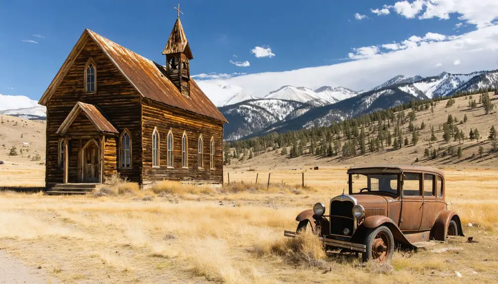
The McInernie Homestead cabin offers photographic inspiration with Wild Bill Hickok-era artifacts framing Sundance Mountain. Shoot RAW format to capture the historical significance in high-contrast scenes:
- Compose stagecoach-era outbuildings with Sundance’s ridge creating diagonal leading lines
- Position the water tower against dawn’s magenta sky for dramatic silhouettes
- Frame scattered mining equipment using rule of thirds with Continental Divide peaks
Your tripod stabilizes everything these crumbling structures can’t—foundation, permanence, clarity.
Frequently Asked Questions
Are There Any Guided Tours Available for Buckhorn Ghost Town?
No guided tours availability exists for Buckhorn—you’ll explore independently, which actually enhances your freedom while discovering the ruins. This self-guided approach supports town history preservation by minimizing foot traffic and maintaining the site’s authentic, untouched character.
Is Overnight Camping Permitted Near the Buckhorn Townsite?
Like pioneers claiming their stake, you’ll find overnight camping permitted near Buckhorn following camping regulations—dispersed sites available within 300 feet of forest roads. Local preservation efforts protect the townsite itself, so you’ll camp nearby respecting historical boundaries.
What Safety Precautions Should Visitors Take When Exploring Abandoned Buildings?
Never enter abandoned buildings at Buckhorn—they’re structurally unstable death traps. If you must peek inside, wear proper protective gear including sturdy boots and gloves. Beware of structural instability: rotted floors collapse without warning, ending your adventure in tragedy.
Are There Any Fees or Permits Required to Visit Buckhorn?
You won’t pay entrance fees to explore Buckhorn’s weathered structures and open spaces. Accessibility for visitors remains unrestricted year-round, though the Buckhorn Bar’s seasonal operating hours vary. Simply arrive, explore freely, and respect this authentic Western ghost town’s untamed character.
exploring buckhorn’s historical significance can provide insight into the lives of those who lived here long ago. The stories behind each dilapidated building and rusted artifact contribute to a deeper understanding of the region’s rich heritage. Engaging with the past in this way enhances the overall experience of the ghost town and encourages visitors to appreciate its unique legacy.
Can I Remove Artifacts or Souvenirs From the Ghost Town?
No, you can’t remove artifacts or souvenirs from Buckhorn. Despite the historical significance of artifacts, you’ll face potential legal consequences including hefty fines and imprisonment. Leave everything untouched—photograph memories instead of pocketing them.