
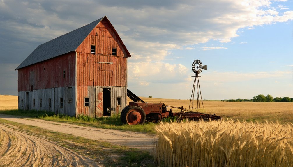
You’ll find Calista 9 miles west of Kingman on the Zenda blacktop—watch for the green highway sign marking this incorporated ghost town of fewer than 10 residents. The weathered blacksmith shop stands as the town’s crown jewel, surrounded by 3-4 remaining homes and a grain elevator that operates just two weeks yearly. Visit during late September through October when harvest season breathes temporary life into the skeleton, and you’ll discover why this twice-relocated settlement makes an ideal anchor point for exploring Southern Kansas’s constellation of abandoned communities.
Key Takeaways
- Calista is located 9 miles west of Kingman on Zenda blacktop, then 0.25 mile south to the Ninnescah River.
- Visit late September through October for optimal harvest season viewing and comfortable temperatures between 50-70°F.
- Key landmarks include a weathered blacksmith shop, 3-4 standing homes, and a small seasonal grain elevator operating two weeks yearly.
- The town relocated twice: from Maud in 1886 to “Old Calista,” then 2 miles west-southwest in 1896 to its current location.
- Combine with nearby ghost town circuits in Rooks, Ellis, Marion, or Franklin Counties for an efficient multi-town exploration route.
The Story Behind Calista’s Three Relocations
The prairie winds swept across Kingman County in 1881 when settlers first established the community of Maud, a cluster of wooden buildings that would become the predecessor to one of Kansas’s most restless towns.
You’ll discover that Calista’s unusual history stems from its three distinct locations. The reason for relocation attempts began when settlers moved from Maud to form “Old Calista” in 1886, naming it after the Greek word for “most beautiful.”
A decade later, the impact of railway demands forced the entire town to pack up again—the Atchison, Topeka and Santa Fe Railway wouldn’t come to them, so they went to the railway. The community shifted two miles west-southwest in 1896, establishing what locals still recognize as Calista’s final resting place.
What Remains at This Southern Kansas Ghost Town
When you arrive at Calista today, a green highway sign welcomes you to what remains of this incorporated town—a designation that feels almost ironic given the skeletal community before you. You’ll spot three or four homes still standing among former residential sites, their weathered facades telling stories of families who chose to stay. The old blacksmith shop survives as the town’s most significant historical structure, a monument to Calista’s working past.
The grain elevator remnants consist of nothing but a dilapidated sign marking where the wooden structure once towered—the local coop demolished it just before 2010, replacing it with concrete silos six miles away. That distant relocation symbolizes everything about modern rural America’s consolidation, leaving communities like this one behind.
Locating Calista requires you to navigate nine miles west of Kingman on the Zenda blacktop, then turn a quarter-mile south toward the Ninnescah River’s south bank. You’ll spot a green highway sign marking this incorporated ghost town—one of Kansas’s most authentic rural attractions along former scenic byways connecting Wichita to Dodge City.
Navigate nine miles west of Kingman on Zenda blacktop, then turn south a quarter-mile toward the Ninnescah River’s bank to find Calista.
Your smartphone’s satellite view reveals the street grid and administrative boundaries. The Sears ranch mansion sits on private property westward. Since Calista’s population hovers under ten residents, you’ll experience genuine solitude while exploring this railroad-era settlement.
Key navigation markers include:
- Green highway sign at the town entrance
- Deteriorated sign near the old wooden elevator site
- Scattered homes and a blacksmith/auto shop structure
- Small operational grain elevator (runs two weeks yearly)
Best Time to Visit the Seasonal Grain Elevator
Once you’ve pinpointed Calista’s location along the Ninnescah River, timing your visit around the grain elevator’s brief operational window transforms a simple ghost town stop into a living agricultural experience. Optimal seasonal conditions converge in late September through October, when you’ll witness the elevator humming with actual grain movement rather than standing silent.
The harvest operations timeline peaks mid-October—farmers hauling wheat through dust clouds while combines work surrounding fields. You’ll catch temperatures hovering between 50-70°F, perfect for exploring without summer’s oppressive heat or winter’s icy hazards.
Spring’s muddy roads and flooding risks make access treacherous, while summer offers excellent photography light but little elevator activity. Fall delivers dry roads, vibrant harvest action, and that authentic Kansas agricultural atmosphere you’re seeking.
Understanding Calista’s Agricultural Heritage
Standing amid Calista’s weathered grain elevator, you’re witnessing the culmination of 150 years of agricultural evolution that transformed Kansas from prairie grassland into America’s breadbasket. This region’s farming heritage runs deep, shaped by pioneers who discovered what worked on unforgiving soil.
From prairie to prosperity: 150 years of Kansas agriculture written in wheat fields and weathered grain elevators.
Calista’s Agricultural Milestones:
- 1873-1879: Kingman County exploded from first settlements to 76,000 cultivated acres
- Early wheat yields: Farmers achieved 30-40 bushels per acre without irrigation
- Alfalfa’s farm revolution: By 1891, this “wonder crop” proved profitable in western Kansas, changing everything
- 1914 peak: Over 9 million wheat acres produced 181 million bushels worth $151.5 million
You’re standing where corn-hog economy homesteaders once worked their 160-acre claims, where hard winter wheat brought by Volga Germans replaced native grasses forever.
Other Abandoned Towns Worth Exploring in the Region
Your adventure doesn’t need to end at Calista—the surrounding Kansas prairie hides several forgotten settlements that’ll transform your day trip into a genuine ghost town expedition.
You can map a loop that connects three or four abandoned sites within a 50-mile radius, giving you diverse stories from railroad decline to drought devastation.
Pack extra water and download offline maps, since cell service disappears between these weathered townsite markers and crumbling foundations.
Nearby Kansas Ghost Towns
While Calista offers its own haunting charm, the surrounding Kansas prairie conceals dozens of forgotten settlements that’ll transform your single-stop visit into an unforgettable ghost town odyssey.
The historical significance of ghost towns becomes visceral when you’re standing where communities once thrived. These sites reveal the impacts of economic decline on rural communities through crumbling foundations and windswept streets.
- Rooks County Circuit: Hit Rockport, Gould City, and Sugarloaf in one sweep—three abandoned dreams within miles of each other
- Ellis County Exploration: Antonino sits south of Hays, while Rome and Turkville offer railroad-era remnants worth photographing
- Marion County Trail: Waldeck and Gnadenau showcase failed farming settlements from the 1870s
- Franklin County Loop: Centropolis and Peoria deliver accessible ruins near modern highways
Each location whispers different stories of Kansas’s boom-and-bust cycles.
Planning Your Multi-Stop Route
Mapping out a ghost town circuit from Calista requires strategic clustering—you’ll burn less gas and see more ruins if you organize destinations by region rather than zigzagging across the prairie like a lost tumbleweed. Start with Kingman County’s tight constellation: Maud (which literally merged with Calista when its post office shuttered in 1886), Mabel, and Milton all sit within a fifteen-mile radius, making them perfect warm-up stops before venturing outward.
From there, choose your adventure: the Western Kansas Ghosts route hits Russell Springs and Diamond Springs along historic trails where hidden histories surface in foundation stones. The Southern Kansas Oil Circuit delivers unexpected discoveries like Midian’s pasture-reclaimed boom site and Oil Hill’s Stapleton Monument. Plot multi-day expeditions or weekend sprints—either way, download offline maps since cell towers don’t care about your archaeological ambitions.
Explore ghost town experiences in Buchanan, where remnants of the past whisper tales of abandonment and resilience. Each dilapidated structure offers a glimpse into a forgotten era, inviting adventurers to unravel the stories etched within their walls. As you wander through these quiet streets, be prepared for moments of reflection and discovery that will enhance your journey.
Frequently Asked Questions
Is Camping Allowed Near Calista or Along the Ninnescah River?
You’ll find absolutely endless wildlife viewing opportunities along the Ninnescah, though camping regulations vary by location. Scout historical marker locations first, then check with local landowners about access. Kansas’s open spaces reward adventurous spirits seeking off-grid freedom.
Are There Any Guided Tours Available for Calista Ghost Town?
Guided tours unavailable for Calista—you’ll explore this forgotten settlement independently. For structured experiences, consider local history tours in nearby Kingman or venture to Atchison’s Sallie House, where paranormal guides share Kansas’s darker tales year-round.
What Photography Rules or Restrictions Apply When Visiting the Grain Elevator?
You’ll find gloriously few restrictions at the grain elevator! Just respect private property boundaries since Skyland Grain Company owns it now, and no unauthorized drone use. Otherwise, you’re free to photograph this architectural relic to your heart’s content.
Are the Remaining Homes in Calista Privately Owned or Abandoned?
The homes’ ownership status remains unclear—you’ll find no posted property values or visible restoration efforts. They appear abandoned, but you shouldn’t assume access rights. Respect potential private property boundaries when exploring this ghost town’s mysterious remnants.
What Safety Precautions Should Visitors Take When Exploring the Area?
Desert temperatures can plunge 40°F after sunset, so you’ll need layered clothing. Wear sturdy boots for exploring crumbling structures, bring adequate water supplies, and never venture alone—freedom means staying safe enough to explore again tomorrow.


