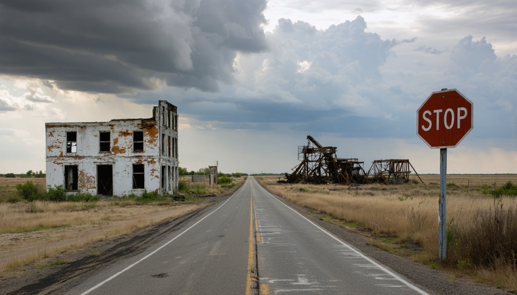
Your ghost town road trip to Cardin starts in northeastern Oklahoma’s Ottawa County, where this once-thriving mining community of 2,640 residents has been reduced to skeletal remnants. You’ll find the town at coordinates 36.97556°N, 94.85167°W, just minutes from Miami along County Road E0030. Watch for the defiant water tower, concrete sidewalks, and a lone standing church amid the contaminated landscape. Since Cardin sits within the Tar Creek Superfund site, you’ll need to take serious safety precautions before exploring what environmental catastrophe left behind.
Key Takeaways
- Cardin is in northeastern Oklahoma near Miami, accessible via Ottawa County backroads at coordinates 36.97556°N, 94.85167°W.
- The site is part of the Tar Creek Superfund area with environmental contamination and poorly maintained infrastructure requiring caution.
- Key remnants include a water tower, church, gorilla statue, concrete sidewalks, and foundations along First Street’s skeletal spine.
- Nearby ghost towns Hockerville and Zincville are accessible via County Road E0030, forming a combined mining district exploration route.
- Miami offers essential services as the nearest functioning town for visitors exploring the abandoned Tri-State mining communities.
The Rise and Fall of a Mining Boomtown
When prospector McConnell broke ground on Felicia Cardin Kenoyer’s 160-acre allotment in 1913, he set in motion the creation of what would become one of Oklahoma’s most prosperous—and ultimately doomed—mining communities.
By 1920, Cardin exploded to 2,640 residents drawn by mineworker life in the Tri-State Mining District’s lead-zinc operations. The boisterous town packed 18-20 grocery stores, theaters, speakeasies, and gambling dens into its streets. Vice and corruption plagued the community, with graft reportedly reaching county offices until a local newspaper editor launched the Anti-Hijaker to expose corrupt officials.
Underground mines stretched 200 feet below while processing mills dotted the landscape every 40 acres. But prosperity proved fleeting. When ore deposits dwindled, population crashed to 437 by 1930. The town disincorporated in 1938, leaving behind contaminated chat piles and toxic streams that fuel today’s ghost town allure. The town’s namesake, Cardin surname, traces back to a family that originated from England and later settled in Portugal as part of Queen Philippa of Lancaster’s entourage.
Getting to Cardin: Location and Route Details
You’ll find Cardin tucked into Oklahoma’s northeastern corner where Ottawa County meets the Kansas and Missouri borders, accessible via U.S. Highway 69 and nearby State Highway 10.
The ghost town sits just minutes from Miami, the county seat, and neighboring communities like Picher and Commerce—all part of the legendary Tri-State mining district.
Your journey will take you through flat prairie terrain at 810 feet elevation, where the Neosho and Spring Rivers carve through land once famous for lead and zinc deposits. The area’s mining legacy left behind galena and sphalerite, the primary ore minerals that made this region one of the world’s most productive lead-zinc mining districts. Cardin’s precise location is marked at 36°55’12″N latitude, 94°51’11″W longitude in the heart of this historic mining territory.
Reaching Cardin by Car
Finding Cardin requires traversing the backroads of Ottawa County in northeastern Oklahoma, where this abandoned mining settlement sits at coordinates 36.97556°N, 94.85167°W. You’ll navigate narrow roads winding through former Tri-State mining district territory, where elevation changes to 810 feet create steep inclines through hilly terrain.
Access Cardin via US highways connecting from Kansas and Missouri borders, then shift onto county routes marked on regional maps. The 0.1-square-mile ghost town sits within ZIP code 74335, adjacent to Picher on USGS topographic maps. The Geographic Names Information System maintains detailed location data for Cardin through its USGS database.
Remember you’re entering the Tar Creek Superfund site—environmental contamination remains present. With zero population since 2010, you won’t find services or maintained infrastructure. Bring detailed satellite navigation and prepare for deteriorating pavement on these remnant mining roads.
Nearby Landmarks and Towns
Once you’ve plotted your route to Cardin, understanding the surrounding ghost towns paints a fuller picture of this desolate corner of Ottawa County. You’ll find Commerce and Picher serving as reference points, while Douthat, Potter, and Treece complete the constellation of mining town legacies scattered across these Quapaw Reservation lands.
The region’s regional tourism potential emerges when you explore:
- Hockerville and Zincville – Former settlements within the Tar Creek Superfund site, once bustling with nearly 1,500 residents
- County Road E0030 – Your primary access route connecting these abandoned communities
- Miami – The nearest functioning town offering essential services for adventurers
Each location followed identical boom-and-bust trajectories, creating an apocalyptic landscape where nature reclaims what mining operations left behind. Zincville was originally named St. Louis after the St. Louis Mining Company that operated there until around 1954. You’re entering authentic frontier territory.
What Remains: Landmarks and Structures to Find
As you navigate Cardin’s eerie landscape, First Street reveals itself as the town’s skeletal spine—concrete sidewalks and house foundations mapping where nearly 3,000 residents once lived.
The beautiful water tower still punctuates the horizon, a defiant monument to the community that thrived here a century ago. Between towering chat piles and barbed-wire barriers, you’ll spot remnants of daily life: copper wiring dangling from industrial structures, stadium lights looming over an abandoned football field, and basketball poles standing guard over empty courts where backboards once hung.
The only standing church in the area offers a haunting glimpse into the spiritual life that once anchored this mining community, though its cemetery has long since disappeared. Look for the gorilla statue among the scattered landmarks, a peculiar survivor of the town’s former businesses and gathering places.
First Street Historic Remnants
Standing at what locals still call First Street, you’ll find yourself on ground that tells its story through absence rather than presence. The eighteen to twenty grocery stores, theaters, and speakeasies that once lined this bustling strip have vanished—destroyed, relocated, or buried beneath mining spoils. Historic building remnants are scarce, making your exploration more archaeological than architectural.
What you’ll encounter instead:
- Foundation shadows where early commercial structures once housed banks, drug stores, and livery stables
- Disturbed earth marking property lines of businesses that served 2,640 miners at peak operations
- A solitary church standing as the last structural witness to Cardin’s boom-era significance
The federal buyout between 2008-2010 erased nearly everything physical, leaving you to piece together history from empty lots and memory. Cardin’s story parallels that of nearby Commerce, which was established in 1914 as a mining camp named Hattonville before transforming into the hometown of baseball legend Mickey Mantle. For contrast, the nearby town of Miami preserves its commercial heritage through structures like the Beauty College Building, where a cast iron facade purchased by the piece from a catalog out of St. Louis was uncovered during a 1998 renovation—one of only sixteen of its kind in Oklahoma.
Abandoned Water Tower Structure
The water tower rises from Cardin’s desolate landscape like a skeletal sentinel, its weathered frame bearing the town’s name in faded letters that refuse to surrender to time. Built during the early 1900s mining boom, this structure once served 3,000 residents who’ve long since vanished. You’ll spot it easily—a vertical monument cutting through the flatlands, surrounded by crumbling foundations and scattered industrial remnants.
Despite minimal historical preservation efforts, the tower’s architectural design features remain intact, standing defiantly among the ruins. Located on tribal land, you can view it from accessible roads threading through this ghost town. It’s your best landmark for navigation, positioned near the town center where foundations and debris tell stories of lives interrupted when government buyouts emptied Cardin in 2009.
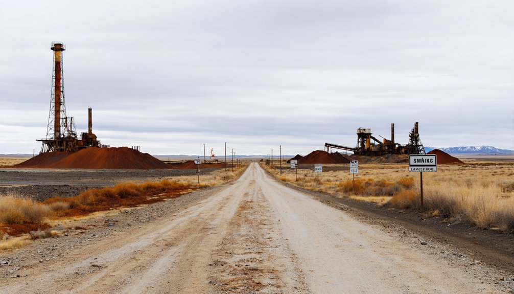
Mining Infrastructure Ghost Remains
Where Cardin’s mining boom once thundered with industrial ambition, you’ll now find a contaminated wasteland scattered with ghostly remnants of extraction’s brutal legacy. The mining era cultural heritage manifests in towering chat piles—mountains of lead-contaminated waste left by companies that abandoned responsibility decades ago.
You’ll spot industrial relics emerging from toxic soil:
- Concrete processing equipment perched atop chat piles like mechanical gravestones
- Barbed wire fencing marking government-restricted contamination zones where freedom ends
- Collapsed mine entrances at Muncie, Big John, and Admiralty sites with diversion channels preventing further flooding
These lingering environmental impacts tell Cardin’s true story—over 400 mining sites await remediation requiring $3.2 million. The landscape itself became evidence: mining depressions, oxidized ore deposits, and contaminated springs flowing with heavy-metal-laden water since 1979.
Understanding the Tar Creek Superfund Site
Nestled in northeastern Oklahoma’s Ottawa County, Tar Creek sprawls across 40 square miles of Quapaw tribal land as one of America’s most contaminated environmental disasters. Designated a Superfund site in 1983, it’s part of the massive Tri-State Mining District where lead and zinc extraction ceased in the 1970s, leaving behind 75 million tons of toxic tailings.
You’ll witness chat piles towering 200 feet high, releasing lead and cadmium dust into the wind. The creek itself runs orange from acid mine drainage—one million gallons daily for over four decades. Any environmental impact assessment reveals devastated groundwater and soil. The long term health consequences forced voluntary buyouts of entire communities.
Despite $300 million in cleanup efforts, this remains one of EPA’s most complex challenges, where contamination flows freely toward the Neosho River.
Safety Precautions for Visiting Contaminated Areas
Visiting Cardin demands awareness that this isn’t your typical abandoned town exploration. Staying safe while exploring requires constant vigilance—every step could reveal a sinkhole that wasn’t visible moments before. The ground beneath you might be supported only by century-old rotting timbers, making careful foot placement essential.
The invisible contamination—lead, zinc, and cadmium—poses as much danger as visible sinkholes. Your freedom to explore comes with responsibility.
Critical safety measures include:
- Visit during daylight hours when you can spot circular cracks, subtle depressions, and warning signs that indicate potential collapse zones
- Avoid disturbing chat piles to prevent lead dust exposure that poisoned generations of children
- Plan your route carefully around deteriorating structures while adhering to restricted areas marked by authorities
Nearby Ghost Towns Worth Exploring
Beyond Cardin’s crumbling foundations, a constellation of ghost towns dots the Tar Creek Superfund site, each one abandoned for the same toxic reasons that emptied your current destination.
Toxic legacy crystallized: ghost towns scattered across poisoned earth, abandoned monuments to an industry that consumed communities whole.
Picher sits closest to Cardin, its massive chat piles towering over demolished buildings. The mining museum fell to arson in 2015, erasing another piece of history.
Cross into Kansas and you’ll find Treece, completely depopulated through government buyout, its toxic remnants visible from Route 66. Douthat rounds out this cluster of evacuated communities, all grouped within the contamination zone.
Despite ongoing local land reclamation efforts and long term environmental remediation, these towns remain frozen in abandonment. You can drive through all three in an afternoon, witnessing firsthand how extraction industries devoured entire communities before vanishing into dust.
Best Practices for Photographing Abandoned Places
Photographing Cardin and its sister ghost towns requires more than just pointing your camera at crumbling buildings. You’ll need to master low light techniques using long exposures and natural ambient light to capture authentic decay without harsh flashes. Scout during golden hour when warm light transforms rust and weathered textures into storytelling gold.
Your best shots will come from unexpected compositions:
- Crouch low or climb high to reveal fresh perspectives on forgotten spaces
- Frame nature reclaiming man-made structures through doorways and broken windows
- Capture intimate details like peeling paint patterns and fractured glass
Pack your tripod for stability in dim interiors, and always bring a companion for safety. These forsaken places reward photographers who respect their boundaries while pushing creative limits to document their haunting beauty.
Frequently Asked Questions
Are There Any Hotels or Campgrounds Near Cardin for Overnight Stays?
You’ll find nearby lodging options in Miami, just minutes away, including Hampton Inn and Motel 6. Local accommodation preferences lean toward Buffalo Run Casino & Resort for comfort, though no campgrounds exist directly in Cardin itself.
What Time of Year Is Best to Visit Cardin Ghost Town?
Spring’s the best season for photographing abandoned buildings at Cardin, when ideal weather conditions for exploring bring mild temperatures and dramatic skies. You’ll avoid summer’s toxic dust and winter’s harsh cold while capturing haunting imagery freely.
Do I Need Special Permits to Enter the Abandoned Town?
You don’t need special permits to explore Cardin’s abandoned streets, though you’ll encounter no-trespassing signs near mining equipment and chat piles. Watch for potential hazards like sinkholes, and respect private property access restrictions where posted.
Can I Bring Children to Visit Cardin Safely?
No, you shouldn’t bring children to Cardin. Safety precautions for children can’t overcome the severe lead contamination still present. There aren’t family-friendly activities in Cardin—dangerous chat piles, unstable ground, and toxic soil make it wholly unsuitable for kids.
Are There Guided Tours Available for the Tar Creek Area?
Yes, you’ll find guided Toxic Tours through L.E.A.D. Agency, where you’ll explore Tar Creek’s mining history and witness ongoing environmental cleanup efforts. Contact the agency directly to arrange your educational journey through this significant Superfund site.
References
- https://www.youtube.com/watch?v=wq7iEpnYDoE
- https://www.youtube.com/watch?v=FZJc5Ivk2J4
- https://www.okhistory.org/publications/enc/entry?entry=CA054
- https://kids.kiddle.co/Cardin
- https://www.youtube.com/shorts/Lqgd0EdYroQ
- https://mamaloi.com/2011/07/15/cardin-oklahoma-ghost-town/
- https://en.wikipedia.org/wiki/Cardin
- https://rmcs-1.itrcweb.org/6-8-tri-state-mining-district-kansas-oklahoma-missouri/?print=pdf
- https://okfronline.com/2020/01/cardin-okla/
- https://scholarworks.uark.edu/cgi/viewcontent.cgi?article=1454&context=etd


