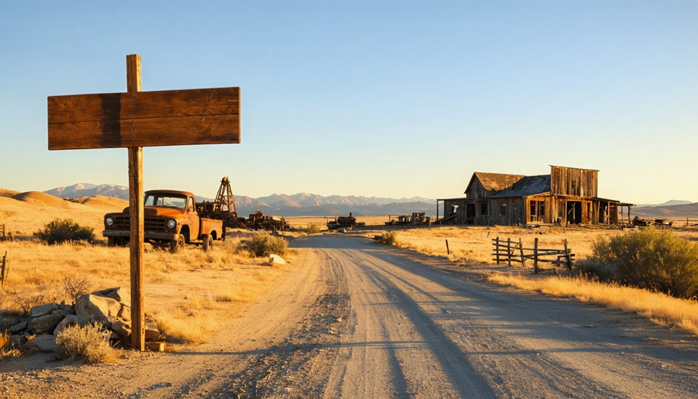
You’ll find Carter tucked at 5,801 feet in Montana’s Bitterroot Range, accessible via an eleven-mile washboard route along Keystone Creek from the Superior Trailhead. This silver-then-gold mining camp demands high-clearance vehicles, sturdy tires, and emergency supplies for the challenging journey through mountain valleys and creek crossings. Plan your visit between late May and early October when dirt roads remain passable. The remote location has preserved newspaper-insulated cabins and mining ruins that reveal the boom-and-bust cycles that defined Montana’s mining frontier.
Key Takeaways
- Access Carter via the Superior Trailhead, following Keystone Creek route for 11 miles through challenging terrain requiring high-clearance vehicles.
- Visit between late May and early October when dirt roads are passable and temperatures are comfortable for exploration.
- Carter sits at 5,801 feet elevation, originally a silver mining camp founded in 1887, later revived for gold in 1911.
- Explore historic remains including newspaper-insulated cabins, mill ruins, and structures from boom-and-bust mining cycles spanning decades.
- Bring emergency supplies and sturdy tires for washboard surfaces, creek crossings, and remote conditions without nearby services.
The Silver Rush Origins of O’Rourke and Its Transformation to Carter
While exploring Spring Gulch‘s rugged terrain in the summer of 1887, five prospectors struck silver galena along what’s now called Keystone Creek—a southwesterly flowing stream that tumbles down from Keystone Mountain to meet the Missoula River.
Phil O’Rourke, who’d grubstaked the expedition after his Bunker Hill success in Idaho Territory, claimed his lion’s share as the team registered their silver deposits discovery: the Iron King and Iron Queen on August 3, followed by Silver Glance and finally the Ivanhoe and Keystone claims.
Despite prospecting challenges faced in this remote wilderness, word spread fast. Within months, 500 fortune-seekers descended on the settlement, initially dubbed O’Rourke. When the post office opened, bureaucrats renamed it Carter after the postmaster—transforming a rough prospector’s camp into an official mining town. In 1891, the town was renamed once more, this time after U.S. Senator Thomas Carter, cementing its place in Montana’s political landscape. By 1890, the town’s population had peaked at over 300 according to the federal census, reflecting the community’s rapid growth during the silver boom.
Gold Discovery and the Keystone Era Resurrection
While O’Rourke’s silver veins had faded to memory, you’ll discover the town’s phoenix moment arrived in 1911 when prospectors struck gold in the surrounding hills.
The discovery sparked immediate action—investors quickly organized the Carter Mining Company to extract ore that assayed at over $45 per ton, a fortune by early twentieth-century standards. What had been a dying silver camp suddenly buzzed with renewed energy as miners, equipment, and capital flooded back into these remote Montana mountains.
This pattern echoed Montana’s first gold discovery in 1852 by Francois Finlay, which launched the territory’s entire mining industry from humble beginnings at Gold Creek. The site, located opposite a creek flowing into the Clark Fork River, marked the beginning of an era that would draw disappointed Pikes Peakers and California prospectors alike to Montana’s promising mineral deposits.
1911 Gold Strike Revitalization
During the 1860s, as prospectors fanned out from Gold Creek’s modest beginnings, they traced promising veins and gulches across Montana’s mineral belt, eventually reaching the remote Carter Mining District in Mineral County.
You’ll find that this regional prospecting movement followed predictable patterns—miners chased rumors from Virginia City’s rich Alder Gulch deposits to Helena’s Last Chance Gulch, then westward through Marysville and Philipsburg. Carter emerged from this mining camp boom at 5,801 feet elevation, where exposed ore shoots assayed at over $45 per ton in gold values.
The gangue materials—galena, quartz, and chalcopyrite—signaled substantial deposits worth the brutal extraction conditions. The 1852 discovery at Gold Creek by Francois Finlay “Benetsee” sparked this prospecting fever after he found gold colors while working the creek’s placer deposits. As operations evolved beyond surface deposits, hard rock mining developed in areas from Marysville to Philipsburg in the late 1860s, introducing deeper shaft operations and quartz vein extraction. Carter eventually joined Montana’s elite fifty-four districts that each produced minimum 10,000 ounces of gold, cementing its place in the state’s mining legacy.
Carter Mining Company Formation
The Carter Mining Company emerged from Montana’s late 1880s consolidation wave, when eastern financiers recognized that scattered claims needed organized capital to survive beyond initial placer exhaustion.
You’ll find the company’s roots in that strategic merger pattern—New York and Montana investors pooled resources to resurrect the Keystone-era claims that’d gone dormant after quartz mill failures. The incorporated leadership mirrored established operations like Boston and Montana Consolidated, though Carter’s capitalization remained modest compared to copper giants.
These financing sources targeted gold persistence while Anaconda pivoted toward copper dominance. By uniting fragmented holdings under Montana’s mineral extraction laws, the company gained infrastructure access and smelting rights that individual prospectors couldn’t afford. Similar corporate consolidations included the Montana Coal and Iron Company, incorporated in November 1889 to develop coal lands, mineral resources, and associated infrastructure. Montana’s dominance in copper production reached its peak in 1890, when 50% of all copper mined in the United States came from the state. It’s classic frontier economics: consolidate or fade into obscurity.
Your journey to Carter begins at the Superior Trailhead, where pavement gives way to the rugged gravel arteries that snake through Chouteau County’s back hills.
The Keystone Creek route carves through mountain valleys for roughly eleven miles, mirroring the challenging approach to similar ghost towns like Garnet, where washboard surfaces and creek crossings test both nerves and suspension systems.
Before you set out, guarantee your vehicle’s equipped with high clearance, sturdy tires, and emergency supplies—this isn’t terrain for low-slung sedans or fair-weather adventurers. Like Capitol in Carter County, this remote settlement represents one of Montana’s scattered prairie ghost towns that требует careful preparation and respect for backcountry conditions.
Montana is home to numerous abandoned settlements, with researchers documenting over 3,800 ghost towns across the country, many concentrated in mineral-rich Western states.
Superior Trailhead Access Point
Traversing to Superior’s remote trailheads demands careful planning, as these dirt roads wind through Mineral County’s backcountry where pavement ends and Montana’s mining history begins. You’ll find dirt road access branching west from the Superior Ranger District into Lolo National Forest’s forgotten mining corridors. Parking availability remains limited at these unmarked pullouts, so arrive early during peak season.
Essential Access Information:
- State Route 522 Junction – Your southern gateway connects from Highway 93 to primary trailhead systems
- High-Clearance Requirements – Summer’s dry conditions favor 2WD vehicles on graded surfaces; fall demands 4WD
- Carlton Ridge Approach – Navigate 4 miles of elevation-gaining road before reaching trail starts
- Diamond Lake Route – Expect 2.8 miles of rocky approach to Cliff Lake Trail #100
Pack navigation tools—cell service vanishes beyond the first ridgeline.
Keystone Creek Route Details
Reaching Keystone Creek’s abandoned mining camp requires commitment to 34 miles of mixed-surface roads that’ll test your vehicle’s clearance and your navigation skills. You’ll tackle challenging trail conditions along East Rosebud Road, where 4000 feet of elevation gain transforms pavement into rugged dirt tracks.
The route follows historic mining corridors through Custer Gallatin National Forest, demanding constant awareness as washouts and rocky sections appear without warning. Your reward? Diverse wildlife sightings including elk, mountain goats, and black bears roaming freely across these untamed landscapes.
Navigate carefully past West Rosebud Trail junctions, where wilderness regulations apply and cell service vanishes. This isn’t a Sunday drive—it’s an authentic backcountry experience where self-reliance matters and the ghost town’s isolation becomes gloriously apparent with each grinding mile forward.
Vehicle Readiness Requirements
The 34-mile gauntlet to Carter’s ghost town demands more than courage—it requires mechanical preparation that separates successful explorers from stranded adventurers. Before tackling these unforgiving dirt roads, you’ll need to address critical readiness factors:
- Tire Maintenance Recommendations: Verify pressure levels (2-6 psi range), inspect for cuts or gouges, and confirm wheel diameter meets 10-inch minimum specifications
- Recovery Equipment: Pack tire repair kits, tow straps, spare plugs, extra fuel, jumper cables, and emergency flares
- Registration Requirements for Street Legal Vehicles: Guarantee your ride has functioning headlamps, stop lamps, horn, mirrors, and muffler—Montana won’t inspect, but breakdowns won’t care about paperwork
- Pre-Ride Protocol: Complete T-CLOC inspection covering tires, controls, lights, oil, and chains
Remote terrain forgives nothing.
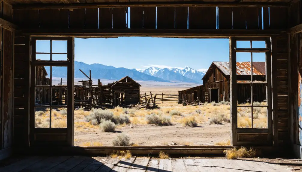
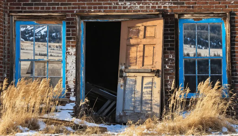
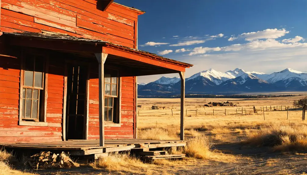
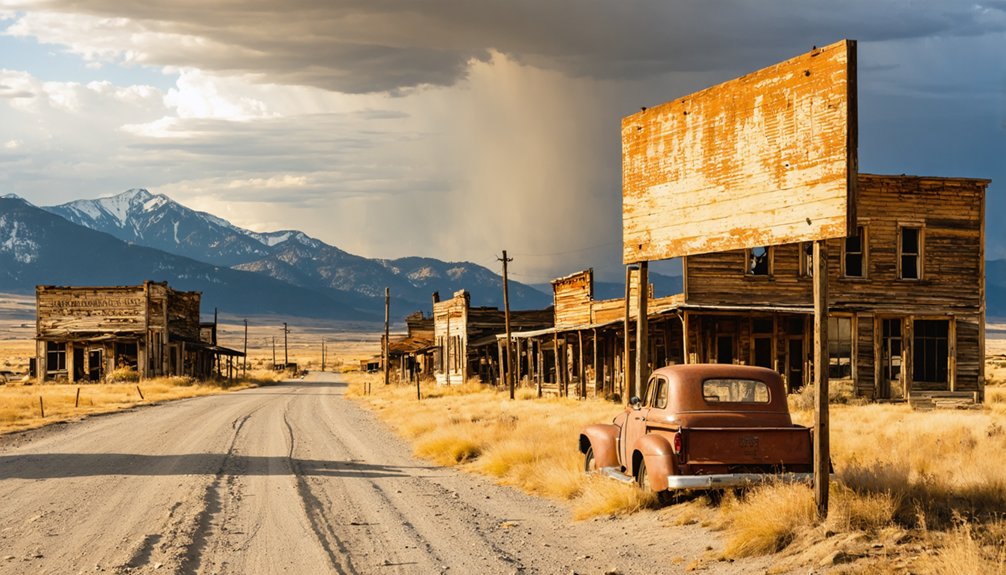
What Remains: Cabins, Mines, and Mountain Ruins
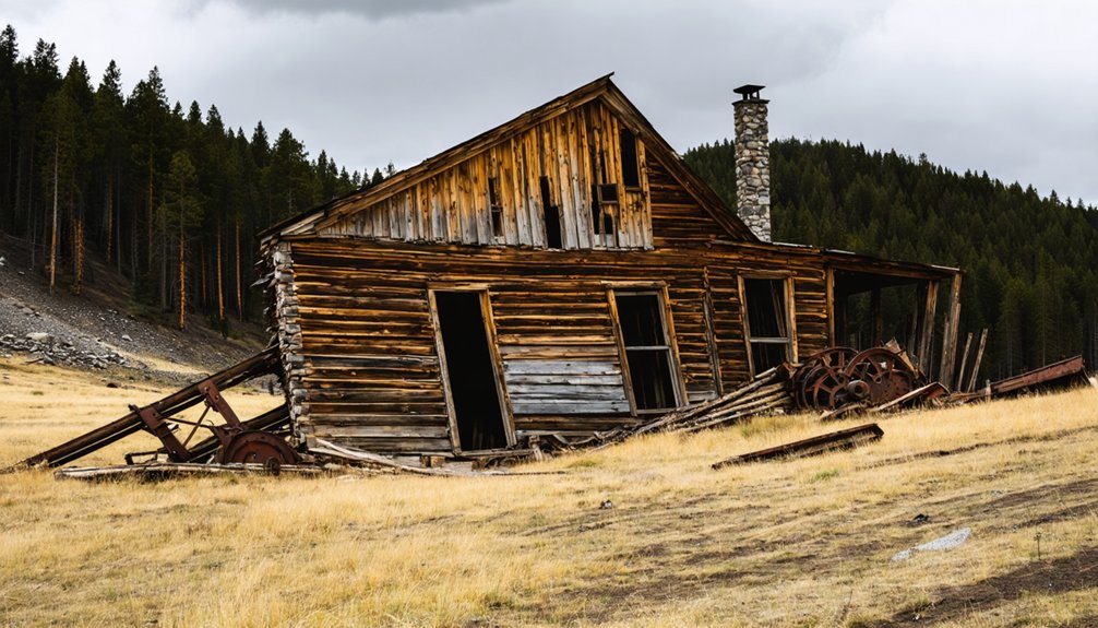
Scattered across Montana’s rugged terrain, the physical remnants of Carter and its neighboring ghost towns tell stories through weathered logs, crumbling stone, and rusted machinery. You’ll find cabins insulated with newspapers and old catalogs—primitive insulation methods that date these structures through their wall materials. The best-preserved buildings, like Tyro house in Coolidge, stand defiant against decay while others crumble into rubble piles.
Mill ruins dot the landscape, from Comet’s deteriorating operations to Coolidge’s former underground hard rock facilities. Stone structures at Elkhorn, including Fraternity Hall and Gillian Hall, dominate the skyline as monuments to the silver mining era. You’ll discover Hecla Mining District’s scattered camps and Taft’s abandoned frame buildings, where nature gradually reclaims what prospectors once built.
Understanding the Boom and Bust Cycles That Shaped the Town
Montana’s mining frontier transformed from sleepy placer operations to industrial powerhouses through distinct economic phases that created—and destroyed—communities like Carter.
Montana’s boom-and-bust mining cycles built thriving frontier towns overnight, then abandoned them just as quickly to economic inevitability.
You’ll recognize four critical cycles that determined Carter’s fate:
- Silver Rush (1870s-1880s): Rich quartz veins sparked rapid settlement, with Carter’s assays showing over $45 per ton gold plus 3.6 oz silver—enough to draw prospectors and establish infrastructure.
- Copper Progression (1880s-1890s): As electrical demand exploded, nearby Butte’s copper production surged 250% in 1883, creating regional mining industry competitors that overshadowed smaller operations.
- Corporate Consolidation (1900s-1920s): The “War of the Copper Kings” reshaped mining operations challenges, forcing independent mines to compete or fold.
- Inevitable Decline: When ore grades dropped and markets shifted, Carter couldn’t sustain itself against industrial-scale operations.
Best Times and Tips for Exploring the Ghost Town
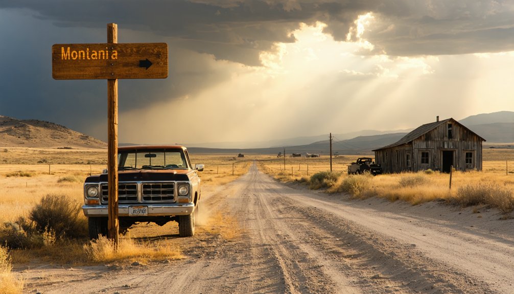
Since Carter’s remote location and extreme weather patterns dictate accessibility, you’ll want to plan your visit between late May and early October when dirt roads remain passable and temperatures hover in the comfortable 60-75°F range.
Pack emergency supplies—extra water, food, and fuel—because services don’t exist for miles in any direction. Download offline maps before you lose cell signal, and inform someone of your itinerary.
Bring sturdy boots for traversing crumbling structures and uneven terrain. Early morning light offers the best photography opportunities, casting dramatic shadows across weathered buildings.
Respect the fragile remains by observing without touching or removing artifacts. You’re not just a tourist here; you’re a temporary guardian of Montana’s untamed history.
Check current road conditions with the county before departing, as spring flooding can unexpectedly close access routes.
Nearby Superior and Bearmouth: Extending Your Montana Adventure
Just thirty miles west of Carter, the historic mining hub of Superior anchors your extended exploration of Montana’s mineral-rich past. You’ll discover layers of frontier history that most travelers never see, from Chinese mining history in Cedar Creek’s gulches to Bearmouth’s legendary lost treasure.
Essential stops for your extended adventure:
- Mineral County Museum in Superior – Free admission to exhibits showcasing local mining operations and Chinese emigrant contributions from the 1870s-1880s
- Cedar Creek Mining District tour – Explore China Gulch’s hearths and abandoned mining relics from temporary settlements
- Pardee ghost town – Hike ten miles north to Iron Mountain Mine ruins hidden in Hall Gulch’s mountainside
- Bearmouth folklore trail – Search for the legendary five-pound baking can fortune while examining 1866-era gold extraction sites
Frequently Asked Questions
Are Camping Facilities Available Near the Carter Ghost Town Site?
No developed campgrounds exist at Carter Ghost Town, but you’ll find dispersed camping options on nearby public lands. You won’t have potential campground amenities like water or toilets, so pack everything you’ll need for backcountry freedom.
Do I Need Permission to Photograph the Cabins on Private Land?
Yes, you’ll need permission. Private property rights protect those cabins, so seeking landowner consent isn’t optional—it’s essential. Respecting boundaries keeps you legally clear while honoring the owners who’ve preserved these historic structures for adventurous souls like yourself.
What Wildlife Should I Watch for While Exploring the Area?
You’ll encounter wildlife everywhere—massive elk herds roaming canyons and coulees, pronghorn racing across grasslands, and spectacular migratory birds like sandhill cranes overhead. Watch for mule deer, bighorn sheep, prairie dogs, coyotes, and golden eagles soaring through Montana’s wild country.
Is Cell Phone Service Available Along Keystone Creek Road?
Cell phone service along Keystone Creek Road is extremely limited or nonexistent. You’ll find minimal signal strength in this remote region, with cell tower locations concentrated in distant towns. Download maps beforehand and prepare for complete communication independence during your adventure.
Can I Legally Metal Detect or Collect Artifacts at the Site?
You’ll need permission before metal detecting at Carter’s ghost town site. Obtaining landowner permission is essential since it’s likely on private or BLM land. Responsible artifact collection means leaving historical items untouched—taking photos preserves your freedom to explore legally.
References
- https://www.historynet.com/keystone-montana-ghost-town/
- https://glaciermt.com/ghost-towns
- https://www.youtube.com/watch?v=lJy7Q8kNbGU
- https://en.wikipedia.org/wiki/List_of_ghost_towns_in_Montana
- https://passionsandplaces.com/elkhorn-montana-ghost-town/
- https://www.distinctlymontana.com/curious-afterlife-montanas-ghost-towns
- https://www.blm.gov/visit/garnet-ghost-town
- http://buttehistory.blogspot.com/2012/
- https://www.verdigrisproject.org/butte-americas-story-blog/butte-americas-story-episode-144-anaconda-mine
- https://books.google.com/books/about/John_E_O_Rourke_Record_Book.html?id=T56J0QEACAAJ