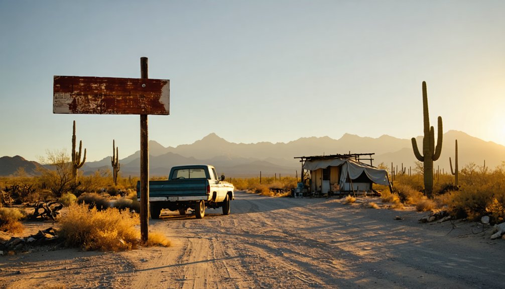
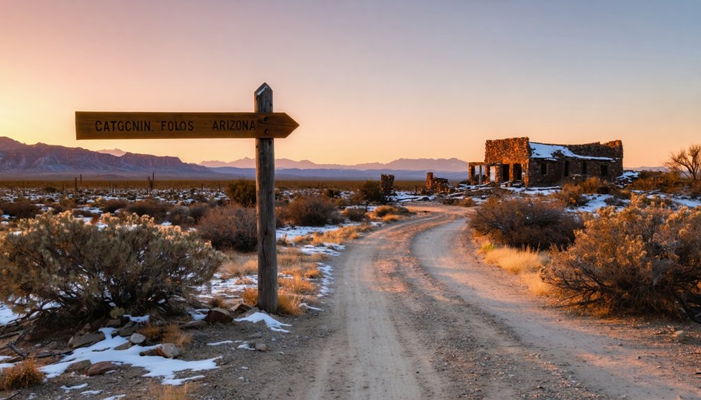
You’ll navigate 2.8 miles of washboard FR-573 dirt road through the Bradshaw Mountains, best tackled in spring or fall when temperatures hover in the 70s-90s rather than summer’s brutal 100°F heat. At 5,079 feet elevation, you’ll discover Catoctin’s crumbling limestone kiln, rusted mining equipment, and adobe walls where twenty miners once extracted gold and silver through 1,000 feet of tunnels from 1927-1937. Arrive at dawn midweek to beat crowds, and you’ll uncover the fascinating details behind this abandoned operation’s rise and eventual collapse.
Key Takeaways
- Take FR-573, a 2.8-mile dirt road accessible to 2WD vehicles, avoiding the barbed-wire-blocked western railroad approach.
- Visit during spring (March-May) or fall for comfortable 70s-90s°F temperatures and stable road conditions midweek at dawn.
- Explore scattered mining ruins including limestone kilns, concrete foundations, adobe walls, and a cemetery from 1927-1937 operations.
- Discover rusted mining equipment, glass artifacts, and remains from 1,000 feet of underground tunnels at 5,079-foot elevation.
- Avoid July-September monsoons causing flash floods and summer heat exceeding 100°F; watch for rattlesnakes and wildlife year-round.
Getting to Catoctin: Routes and Vehicle Requirements
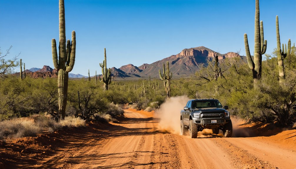
The narrow ribbon of FR-573 peels away from Highway 89 like a dirt scar on the landscape, carrying you 2.8 miles through mesquite and juniper toward what remains of Catoctin. Your 2WD sedan handles this route fine—no lifted truck needed here. I’ve watched minivans make this run without complaint.
Road condition challenges emerge after summer monsoons when ruts deepen and washboard sections rattle your fillings loose. Weather impact considerations matter most in winter, when rare snowmelt turns clay stretches slick. The old bridge over Hell Canyon sits permanently closed now, quarry operations ending that shortcut forever.
Barbed wire blocks the western railroad approach—don’t bother. Stick to FR-573. Chain-link fencing surrounds the crumbling kiln, USFS warnings posted everywhere about structural instability. The town’s name of Algonquian origin appears in multiple other locations across the Mid-Atlantic United States, though this Arizona settlement bears no direct connection to those eastern counterparts. Like the American Ranch stage stop that once served the Prescott-Ehrenburg route, Catoctin functioned as a waypoint for travelers crossing Arizona’s harsh terrain. Respect them.
What Remains at the Historic Mining Settlement
At 5,079 feet, Catoctin clings to a nameless tributary that feeds the Hassayampa River, its single remaining structure defying gravity and time in equal measure. You’ll find scattered mining equipment rusting among Proterozoic rocks—remnants of gold and silver operations that peaked between 1927 and 1937. The 1,000 feet of underground workings remain, though accessing them isn’t recommended.
What makes this place special are the undiscovered archaeological sites you’ll stumble upon while exploring. Keep your eyes open for local wilderness fauna—mule deer, javelina, and hawks patrol these canyons. Like other Arizona mining districts where over 300 mines once operated, Catoctin represents just one chapter in the state’s vast mineral extraction history.
The barren settlement demands respect; you’re truly off-grid here. Pack water, tell someone your plans, and remember: Catoctin rewards those who venture beyond marked trails, offering solitude that civilization can’t touch. The site operated as a vein deposit mine, with ownership passing through the Catoctin Mining Co. and C. W. Walker during its productive years.
Best Times to Visit the Desert Ghost Town
When you’re planning your journey to Catoctin, timing isn’t just convenient—it’s essential to survival in this unforgiving landscape. Spring and fall offer your best windows, with temperatures hovering in the comfortable 70s-90s°F range. You’ll avoid the brutal summer heat that exceeds 100°F daily and the freezing nights of winter months.
Seasonal planning considerations matter here—arrive mid-week at dawn to dodge weekend crowds and secure parking near historic mining attractions. March through May provides ideal conditions for exploring abandoned structures, though watch for rattlesnakes during warming periods. Skip July through September entirely; monsoon flash floods turn dirt roads treacherous. Winter’s 65°F days work for midday visits, but pack layers for those sub-freezing nights. Most attractions and shops operate from 10 a.m. to 5 p.m., so plan your arrival accordingly to maximize your exploration time. Check for alerts before planning to stay informed about temporary closures or hazardous conditions that could impact your ghost town exploration. Your freedom demands respect for the desert’s rhythm.
The Rise and Fall of Catoctin’s Mining Operations
Gold fever drew desperate prospectors to this remote canyon in 1902, where the glint of precious metal in Proterozoic crystalline rock sparked the birth of Catoctin. You’ll find early ownership details reveal Catoctin Mining Co. and C. W. Walker staked their claims first, carving 1,000 feet of underground tunnels chasing gold and silver veins through fault-shattered stone.
Desperate prospectors carved 1,000 feet through fault-shattered stone, chasing precious metal veins that glinted in ancient Proterozoic rock.
The camp’s golden decade stretched from 1927 to 1937, when miners extracted ore from depths few dared explore:
- Lantern shadows dancing across crystalline walls 5,079 feet above sea level
- Powder smoke drifting through narrow shafts
- Ore carts rattling toward sunlight
- Twenty souls betting everything on rock
The underground operation reached 400 feet deep, where miners worked the tabular ore body running through diorite host rock. Later operator challenges mounted as Gold Bend Partners discovered what others learned: small deposits don’t sustain dreams. By 1937, the veins played out, and freedom-seekers abandoned their claims to the desert silence. Today, the mine opening stands among Arizona’s estimated 100,000 abandoned sites, a testament to fortunes lost and dreams surrendered to time.
Exploring the Site: What to Look For
When you arrive at Catoctin’s barren coordinates, don’t expect dramatic ruins—you’ll strain to spot foundations barely rising above the desert floor, their crumbling stones now indistinguishable from the natural rock scatter.
I’ve learned to walk slowly here, eyes fixed downward, because the real treasures are small: a rusted pickaxe blade half-buried in hardpan, fragments of purple glass that once held medicine, square nails oxidized to orange dust.
The mining debris tells Catoctin’s story better than any standing structure could, each corroded piece of equipment marking where twenty souls once swung hammers and dreamed of silver. Keep your eyes peeled for industrial artifacts like mining equipment that reveal how miners once worked this unforgiving land. Unlike Arizona’s famous silver mining boomtown Tombstone, which draws over 400,000 tourists annually to its well-preserved streets, Catoctin offers only whispers of its former life.
Remaining Structure and Ruins
Scattered across the desert landscape like puzzle pieces from a forgotten era, Catoctin’s ruins tell stories through concrete, brick, and crumbling adobe. You’ll discover crumbling historic structures ranging from roofless business district buildings to the 1909 jail shell with its intact roof reinforcement.
Buried residential remnants lie semi-deep in earth, while mine ruins from operations like Bluebell and Monte Cristo dot the hillsides.
As you explore, watch for:
- Limestone kiln ruins fenced off west of Highway 89—unstable but photogenic
- Concrete foundations with original steps leading nowhere
- Adobe walls along abandoned railroad beds
- Cemetery remnants nestled near foundation clusters
The creekside area reveals nature’s slow reclamation, where corrugated metal shells and wooden cabin remains blend into sagebrush. One original building still stands defiantly among the foundations.
Scattered Mining Equipment Artifacts
Where underground ambition met desert reality, Catoctin’s miners left behind a mechanical graveyard that’s still visible today. You’ll find ore processing equipment scattered around the 1,000 feet of underground workings, remnants from the mine’s productive decade between 1927 and 1937. Trek the half-mile to discover foundations where milling operations once crushed gold, silver, copper, and lead ore.
The most compelling artifacts predate European settlers entirely. Ancient stone tools lie scattered in trenches and adits—evidence of Native American turquoise mining operations from a thousand years ago. These hammers connect you to Catoctin’s deepest roots. Look carefully along ore haul paths where burro pack trains once traveled. The desert’s preserved these turquoise mining relics remarkably well, offering you tangible links to both ancient and industrial extraction methods at 5,079 feet elevation.
Preparing for Your Desert Ghost Town Adventure
Your journey to Catoctin starts long before you turn off U.S. 89 onto those rough dirt tracks—it begins with loading your 4WD vehicle with the right gear and understanding when the Yavapai County desert shows its friendliest face.
I learned the hard way that “accessible anytime” doesn’t mean comfortable anytime, watching my water supply dwindle under July’s relentless sun near those rusted mining remnants. Pack your vehicle like you’re planning for isolation, because once you leave the highway, you’re committed to miles of remote terrain where preparation separates adventure from emergency.
Essential 4WD Vehicle Requirements
Before you set off toward Catoctin’s abandoned mining structures and sun-bleached buildings, understanding your vehicle’s capabilities could mean the difference between adventure and disaster. You’ll need a factory stock full or mid-size 4×4 pickup or SUV with adequate ground clearance as your primary safety equipment. That crossover gathering dust in your driveway won’t cut it—Catoctin’s desert trails demand off road traction requirements that only proper off-pavement tires can deliver.
Your rig must include:
- All-terrain or mud-terrain tires that grip loose sand and sharp rock equally well
- Short wheelbase design to navigate tight switchbacks around canyon walls
- Protected underbody free from vulnerable running boards or plastic bumpers
- Mechanical reliability ensuring self-rescue capability miles from cell service
Inspect everything thoroughly. Your freedom depends on preparation.
Desert Safety Gear Checklist
The Arizona sun beats down with relentless intensity on Catoctin’s crumbling structures, transforming your desert expedition into a survival scenario if you’ve packed carelessly. You’ll need proper hydration reservoir maintenance—rinse your bladder with vinegar weekly to prevent bacterial growth that’ll leave you sidelined.
Pack sun protection clothing options like lightweight long sleeves and wide-brim hats; I’ve learned the hard way that cotton tees won’t cut it against Yavapai County’s UV assault.
Load your GPS with offline maps, throw a satellite communicator in your pack, and stash extra water bottles in your vehicle’s cargo area. Your first-aid kit should include snakebite supplies and heat exhaustion remedies.
Pack emergency signaling mirrors, mylar blankets, and high-calorie trail snacks—freedom means self-reliance when cell towers disappear.
Optimal Seasonal Timing Considerations
Packing the right gear won’t matter if you’re trudging through ankle-deep mud or gasping in 115-degree heat while examining Catoctin’s weathered timbers. Strategic timing transforms your adventure from ordeal to discovery.
Spring’s March-to-May window delivers comfortable exploration temperatures, though water access concerns intensify as desert springs dwindle. Fall’s September-through-November stretch provides ideal conditions—cooler mornings perfect for photographing that solitary standing building without heat shimmer distorting your shots.
Consider these seasonal accessibility challenges:
- Spring rains transform access roads into 4WD-mandatory mud tracks
- Summer’s 115°F peaks force pre-dawn departures or sunset visits
- Winter’s rare snowfall creates unexpected navigation obstacles
- Flash flood season threatens low-lying areas near canyon washes
Monitor weather forecasts religiously before departure. That crumbling mining equipment isn’t going anywhere, but your safe passage depends on choosing wisely.
Frequently Asked Questions
Are There Any Nearby Ghost Towns Worth Visiting on the Same Trip?
You’ll find several abandoned mining settlements clustered in the Bradshaw Mountains south of Prescott. Walker and Goodwin offer nearby historic landmarks worth exploring, while Tip Top’s crumbling saloons and Constellation’s two-story ruins reward your adventurous spirit with authentic frontier atmosphere.
Is Camping Allowed at or Near the Catoctin Ghost Town Site?
No Catoctin ghost town exists in Arizona—it’s actually in Maryland. However, you’ll find nearby campgrounds throughout Arizona’s backcountry where dispersed camping’s permitted with minimal restrictions. Just follow the 14-day limits and you’re free to roam.
Exploring ghost towns in Arizona can be a fascinating adventure, offering a glimpse into the state’s rich history and mining past. Many of these towns are accessible via scenic drives, making them a perfect addition to a weekend getaway. Be sure to pack enough supplies, as some locations are quite remote and require preparation for your journey.
What Photography Restrictions or Guidelines Exist for the Historic Site?
You’ll find no drone usage policies restricting your aerial shots here. Photography equipment guidelines remain relaxed—bring tripods and cameras freely. Personal use photography’s encouraged without permits, though professional shoots requiring compensation need advance authorization and insurance documentation.
Are Guided Tours Available for Exploring Catoctin’s Mining Remnants?
No guided tours are available for Catoctin’s remote mining remnants—you’ll explore solo, discovering rusted mining equipment artifacts scattered across windswept desert hills. Pack water, wear boots, and embrace total freedom wandering this forgotten landscape at your own adventurous pace.
Does Catoctin Have Any Documented Paranormal Activity or Ghost Stories?
No, you won’t find documented paranormal activity or haunting legends at Catoctin. The town’s peaceful abandonment left no unexplained occurrences behind—just one lonely building standing sentinel over the quiet Bradshaw Mountains, free from spectral tales.
References
- https://www.ghosttowns.com/states/az/catoctin.html
- https://azgw.org/yavapai/ghosttowns.html
- https://janmackellcollins.wordpress.com/category/arizona-ghost-towns/
- https://kids.kiddle.co/List_of_ghost_towns_in_Arizona
- https://npshistory.com/publications/cato/human-conservation-pgms-srs.pdf
- https://blog.batchgeo.com/ghost-towns/
- http://www.azarchivesonline.org/xtf/view?docId=ead/uoa/UAMS562.xml;query=;brand=default
- https://en.wikipedia.org/wiki/Catoctin
- https://www.arizonahighways.com/ghost-town-trail
- https://www.therockerbox.com/yavapai_county_az_ghost_towns.htm


