
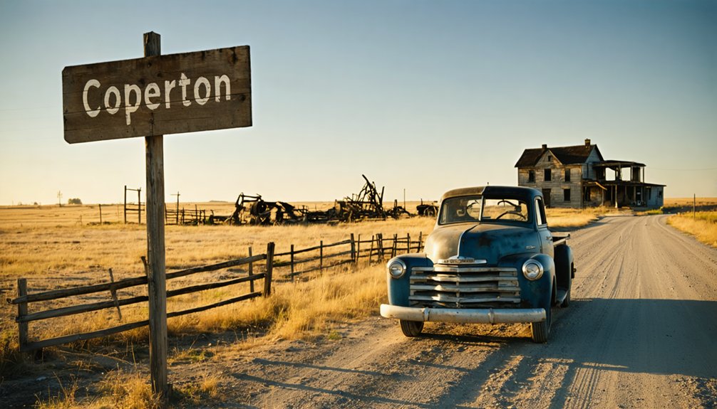
You’ll find Cooperton in southwest Oklahoma, where weathered stone foundations and crumbling structures from 1899 mark one of the state’s most accessible ghost towns. This former reservation settlement’s population crashed from 187 residents in 1940 to just 3 today, leaving behind an original church, abandoned gymnasium, remnants of a 1927 bank, and scattered farm buildings across 320 acres. You can explore the visible ruins in an afternoon, though you’ll want to know the full story of how lottery land claims and agricultural shifts created this haunting landscape.
Key Takeaways
- Cooperton is located in southwestern Oklahoma, founded in 1899 with a peak population of 187 in 1940.
- Explore visible ruins including stone foundations, the original church, abandoned gymnasium, 1927 bank remains, and defunct filling station.
- View agricultural remnants like weathered barns, rusted equipment, abandoned windmills, and collapsed grain storage across the former farmland.
- Exercise caution when exploring due to toxic dust hazards from nearby chat mining operations in the area.
- Visit the nearby archaeological site featuring the Cooper Bison Skull, North America’s earliest known painted object from 18,000 years ago.
The Story Behind Cooperton’s Founding and Name Change
Deep in the rolling plains where the Wichita Mountains meet the Oklahoma prairie, a visionary former Confederate captain named Frank Cooper saw opportunity in 1899. He organized a 300-member settlement company anticipating the Kiowa, Comanche, Apache Reservation‘s opening in August 1901. When land distribution changed from run to lottery, Cooper secured 320 acres for his company.
An interesting townsite registration error placed the settlement two miles from its intended location at the mountains’ base. Another complication arose when Cooper discovered Blaine County already claimed his namesake town. The settlement became “Cooperton” instead.
Despite failed railroad acquisition hopes, Cooperton flourished with eighteen businesses, churches, schools, and the Cooperton Banner newspaper. The town’s commercial district included essential enterprises like a livery stable, drug store, bank, hardware store, and cotton gin serving the agricultural community. By 1940, this resilient community reached 187 residents—proof that determination trumps setbacks. The community’s fortunes eventually reversed, with the population declining to 20 by the start of the 21st century.
What Remains of Cooperton Today
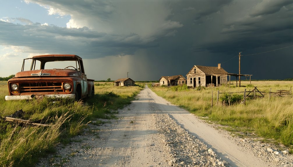
When you arrive in Cooperton today, you’ll find a landscape where nature has largely reclaimed what was once a thriving community of 187 people. Scattered farm buildings and weathered structures dot the half-square-mile area, offering tangible connections to the families who called this place home for generations.
A handful of descendants still maintain ties to the land, serving as living bridges between Cooperton’s bustling past and its present population of just three residents. The town’s decline mirrors broader patterns of federal workforce reductions that have affected rural communities throughout the twentieth century. If you’re planning a visit, be aware that wildfires are burning in nearby Beaver County and Texas County, with some fires moving east-northeast and prompting evacuations in affected areas.
Visible Ruins and Structures
Although Cooperton’s bustling streets fell silent decades ago, the skeletal remains of its former glory still punctuate the Oklahoma landscape. You’ll discover stone foundations marking where homes once stood, alongside crumbling residences from the town’s 1899 founding.
The original church building endures among the ruins, while the abandoned gymnasium creates an eerie atmosphere. Commercial remnants include a 1927 bank, a defunct filling station, and scattered sites where the general store, hardware shop, and drug store operated.
The cotton gin and mill structures testify to Cooperton’s agricultural heritage, though architectural styles now deteriorate without historical preservation efforts. Located in Kiowa County, Cooperton experienced its decline sometime between the 1930s and 1970s, leaving behind the few residences and structures visible today. You’ll need caution exploring—these structures offer no safety guarantees, with toxic dust from nearby chat mining adding another hazard to your off-the-beaten-path adventure. Like the massive chat hills surrounding Picher, these mine waste piles contain dangerous heavy metals that once went unrecognized by recreational visitors.
Farm Buildings and Remnants
Beyond Cooperton’s crumbling commercial district, the surrounding farmland tells its own story of transformation and abandonment. You’ll discover agricultural relics scattered across what was once thriving farm country—weathered barns leaning against Oklahoma winds, rusted equipment half-buried in prairie grass, and foundations where family homesteads once stood. These overgrown structures mark the shift from individual farms to consolidated corporate operations that began decades ago.
Mechanization and inflated land prices drove families away, leaving behind skeletal reminders of self-sufficient living. The original townsite covered 320 acres of land blanketed in Grama and Blue Stem grass when Frank Cooper’s company planned the settlement in 1899. The farming and ranching region stretches along State Highway 54/19, where Cooperton first took root after the opening of the Kiowa, Comanche, and Apache Reservation in 1901. As you explore fourteen miles south of Gotebo, you’re witnessing the physical evidence of agricultural evolution—abandoned windmills, collapsed grain storage buildings, and fence lines reclaimed by native vegetation. Each deteriorating structure represents families who worked this land before corporate ranching reshaped Kiowa County’s farming identity.
Original Family Descendants
The stark arithmetic of Cooperton’s decline tells a story more powerful than any fading photograph could capture. From 187 souls in 1940 to just 3 by 2020, this ghost town has scattered its long lost descendants across the nation.
You’ll find few original family bloodlines remain in this wind-swept settlement. Most pioneers’ grandchildren and great-grandchildren migrated to urban centers decades ago, chasing opportunities their ancestors couldn’t find here. The family histories preserved in county records and genealogical archives reveal a pattern of exodus beginning in the 1960s.
Today’s Cooperton exists as a geographic footnote where perhaps one elderly resident guards memories of bustling school days and thriving ranches—living proof of how quickly American dreams can vanish into prairie dust. Yet beneath this desolate landscape lies evidence of a far deeper human timeline, as the nearby Cooperton archaeological site reveals human presence extending back approximately 18,000 years. Among the remarkable discoveries here is the Cooper Bison Skull, a painted artifact dating between 10,900 and 10,200 radiocarbon years ago that stands as the earliest known painted object in North America.
Getting to Cooperton in Southwest Oklahoma
Nestled in the rolling plains of Kiowa County, Cooperton sits roughly 14 miles south of Gotebo and 9 miles east of Roosevelt, accessible via a network of rural roads that slice through Southwest Oklahoma’s prairie landscape.
You’ll find this ghost town at coordinates 34°51′59″N 98°52′15″W, perched at approximately 1,555 feet elevation. The USGS Cooperton quadrangle map proves indispensable for navigation, though dirt roads accessibility requires a 4WD vehicle—particularly pivotal given seasonal weather conditions that can transform these routes into challenging passages.
Spring rains and winter freezes dramatically impact road conditions, so timing your visit matters. The town covers just 0.5 square miles of open terrain, where expressway and local connector roads guide you toward this slice of frontier history waiting in Kiowa County’s backcountry.
The Rise and Fall of a Reservation Town
When Frank Cooper, a former Confederate States Army captain, envisioned a thriving settlement in 1899, he couldn’t have predicted the registration error that would shift his planned townsite two miles from its intended location at the foot of the Wichita Mountains. Despite this setback, Cooperton flourished after the 1901 reservation opening, attracting 300 company members who built general stores, hotels, a cotton gin, and even a cigar factory.
The demographic changes tell a stark story: population peaked at 187 residents in 1940, then plummeted to just three by 2020. Economic fluctuations devastated the community when schools closed and businesses shuttered. Without railroad access, Cooperton couldn’t compete with neighboring towns. Today, it’s officially a ghost town, though former residents still gather at the preserved community center for biennial reunions.
Best Times to Visit This Disappearing Settlement
Planning your ghost town adventure requires strategic timing, as Cooperton’s extreme weather swings dramatically between seasons. Spring and fall emerge as ideal visitation seasons, offering mild temperatures perfect for exploring abandoned structures and photographing weathered buildings without weather interference.
You’ll want to dodge summer’s oppressive heat and stifling humidity—conditions locals describe as “hotter than heck”—which make outdoor exploration uncomfortable. Winter’s biting cold and relentless winds create equally harsh conditions for wandering through this nearly-deserted settlement.
Recommendations for weather-friendly activities center on these moderate seasons when you can freely roam the quiet streets and investigate the closed school gymnasium and remaining churches. The accessible 2WD roads guarantee you won’t face navigation challenges, letting you focus on documenting this fading piece of Oklahoma history.
What to Photograph and Explore

Cooperton’s photographic treasures reveal themselves in layers of architectural decay and frozen-in-time artifacts that tell stories of a once-thriving community. You’ll discover the Baptist Church’s stunning stained glass windows casting blues and greens across rock walls, while quirky architectural details like a horse clock adorn abandoned commercial buildings.
The gymnasium harbors a pristine 1950s car beneath blue-green tinted windows—evidence of unique preservation efforts by remaining residents who’ve repurposed structures for storage. Don’t miss the playground’s weathered swings and intact jungle gym, or the car graveyard where rust creates haunting blue-green patinas on mid-century automobiles.
Photograph the derelict service station, old bank crowned with tire mounds, and store buildings that showcase Cooperton’s rock-faced construction throughout this vanishing settlement.
Other Ghost Towns Near Cooperton Worth Visiting
Your Cooperton adventure opens doors to several fascinating ghost towns scattered across southwestern Oklahoma’s rural highways. Within a 50-mile radius, you’ll discover abandoned settlements from Washita’s crumbling structures to Gotebo’s land lottery heritage, each telling unique stories of Oklahoma’s territorial past.
The region’s concentration of ghost towns—stretching from the Wichita Mountains area through Kiowa County and down to the Red River border—creates an ideal multi-day exploration route through forgotten communities shaped by land runs, agricultural booms, and inevitable decline.
The allure of exploring ghost towns near Oklahoma lies in the stories etched into their abandoned structures and the landscapes that surround them. Each site offers a glimpse into the past, revealing the resilience of those who once called these places home. As you navigate through the remnants of history, you’ll uncover the fascinating tales of the people and events that shaped these now-silent towns.
To truly immerse yourself in this experience, plan a ghost town adventure that takes you off the beaten path. Each stop along the way invites you to imagine the lives once lived in these now-desolate locations, prompting reflections on the passage of time and the impact of human endeavor. As you wander among the ruins, the presence of history becomes palpable, making each moment spent an unforgettable journey into the heart of the American past.
Lugert and Lake Altus
While exploring the ghost towns near Cooperton, you’ll discover Lugert’s remarkable story of resilience and transformation beneath the waters of Lake Altus-Lugert. Founded in 1901 by merchant Frank Lugert, this thriving community of 300-400 residents survived a devastating 1912 tornado that destroyed 41 of 42 buildings.
The town’s fate was ultimately sealed when a dam was raised 50 feet in the late 1940s to support regional farming practices, submerging the original townsite under 10 feet of water.
Today, seasonal flood patterns reveal Lugert’s haunting remains when drought conditions drop the lake to critical levels. During the 2015 drought, the reservoir fell to just 9% capacity, exposing foundations and brick piles from this once-prosperous settlement that now serves southwestern Oklahoma’s agricultural needs.
Kiowa County Ghost Towns
The landscape surrounding Cooperton hides several forgotten settlements that tell the broader story of Kiowa County’s turbulent early years. Roosevelt, established in 1901, still shows abandoned structures you can explore today along rural backroads.
Wildman emerged during the same early boom—one of 60 small towns that dotted Kiowa County between 1900-1918 before economic reality crushed homesteader dreams. You’ll find Gotebo south of Cooperton, originally named Harrison after President Benjamin Harrison during the 1901 land opening. Now it’s a semi-ghost with crumbling foundations where abandoned schoolhouses once taught pioneer children.
These settlements share Cooperton’s fate: railroad bypasses, failed agricultural promises, and decommissioned cemeteries marking communities that couldn’t survive Oklahoma’s harsh shift from territory to statehood.
Wichita Mountains Area Settlements
Beyond Kiowa County’s scattered homesteads, the Wichita Mountains region holds its own collection of abandoned settlements that paint a vivid picture of southwestern Oklahoma’s boom-and-bust frontier era. You’ll discover abandoned farms tucked into rocky valleys where homesteaders once wrestled with unforgiving terrain and scarce water sources. These remote sites offer unobstructed views of granite peaks rising from prairie grasslands.
The area’s tribal land histories add complex layers to your exploration, with former Comanche and Kiowa territories intersecting settlement patterns. Many abandoned homesteads sit near the Wichita Mountains Wildlife Refuge boundaries, where agricultural dreams met geographic reality. You’ll find stone foundations, collapsing barns, and weathered fence posts marking where families attempted to carve out independence before nature reclaimed their efforts. Each site tells stories of resilience and ultimate surrender.
Essential Tips for Your Ghost Town Adventure
Before you set out to explore Cooperton’s weathered remnants, prepare for a journey into rural Kiowa County where modern conveniences fade like the town itself. Located nine miles east of Roosevelt near the Wichita Mountains, you’ll navigate unpaved roads with limited services—pack water, fuel up beforehand, and bring a reliable GPS.
The disappearing town offers no tourist infrastructure, just authentic ruins and abandoned structures waiting for discovery. Though restoration efforts remain minimal, the site’s raw, untouched character appeals to adventurers seeking genuine encounters with Oklahoma’s frontier past.
Time your visit around July’s annual reunion to witness community ties that endure despite depopulation. You’ll find corporate farms replacing original homesteads, but Cooperton’s stubborn spirit persists among scattered buildings and forgotten streets.
Frequently Asked Questions
Are There Any Safety Concerns When Exploring Abandoned Structures in Cooperton?
Like stepping into a crumbling time capsule, you’ll face structural integrity concerns from deteriorating buildings and potential hazardous materials exposure in Cooperton. Rotting floors, unstable walls, and unknown contaminants demand your vigilance—explore wisely, tread carefully, embrace adventure responsibly.
Do I Need Permission to Access Private Property at the Site?
Yes, you’ll need to obtain landowner permission before exploring private property in Cooperton. While roads are accessible, occupied homes and derelict structures likely sit on private land. Always check for legal access to respect residents’ rights.
Are There Nearby Facilities for Food, Gas, and Restrooms?
Like a desert mirage, amenities availability vanishes in Cooperton’s three-person ghost town. You’ll find nearby dining options, gas, and restrooms requiring a 9-mile trek west to Roosevelt or 14 miles north to Gotebo—plan accordingly.
Can I Camp Overnight Near Cooperton or in the Wichita Mountains?
Yes, you’ll find excellent camping at Doris Campground in Wichita Mountains Wildlife Refuge near Cooperton. You’ll enjoy scenic vistas, wildlife sightings of bison and elk, plus 90 campsites ranging from electric hookups to primitive walk-in sites.
What Cell Phone Coverage Can I Expect in This Remote Area?
You’ll find decent coverage from major carriers in Cooperton, though signal reliability can be spotty in this rural area. Cell tower locations are limited, so T-Mobile and AT&T’s 100% county coverage offers your best connection for off-grid adventures.
References
- https://en.wikipedia.org/wiki/List_of_ghost_towns_in_Oklahoma
- https://abandonedok.com/cooperton-ok/
- https://www.youtube.com/shorts/s86WlCfhU8Y
- https://ahgp.org/ok/kiowa-county-towns-of-the-past.html
- https://en.wikipedia.org/wiki/Cooperton
- https://ahgp.org/ok/cooperton-oklahoma-history.html
- https://www.comanchecountyok.gov/181/County-History
- https://www.okhistory.org/publications/enc/entry?entry=PR008
- https://ahgp.org/tag/cooperton-ok
- https://abc7amarillo.com/news/local/multiple-fires-burning-across-texas-and-oklahoma-panhandles-amid-high-winds-severe-weather-wildfires-beaver-county-hartley-hooker-highway-64-hwy-87


