
You can’t drive to Copperfield—the entire town now lies buried hundreds of feet beneath Bingham Canyon Mine‘s terraced walls. The last 15 families evacuated by August 1958 when Kennecott’s bulldozers erased every brick home and street. Instead, head to the mine’s visitor center for dramatic views of where Copperfield once clung to Bear Gulch’s mountainsides, or explore preserved photographs at Utah State Historical Society that capture this vanished community. Summer offers ideal conditions for discovering what remains of this copper-rich canyon’s complex story.
Key Takeaways
- Copperfield no longer exists, demolished in 1958 when Kennecott’s Bingham Canyon Mine expansion consumed the entire townsite.
- The original townsite is permanently inaccessible, now buried hundreds of feet underground within active mining operations.
- Visit Kennecott’s visitors’ center at the pit’s northwest corner for views of where Copperfield once stood.
- Explore photographic archives at Utah State Historical Society and BYU Marriott Library to experience Copperfield’s 1912-1957 history.
- Plan summer visits to nearby Copperton, the 1926 model community offering the closest remaining access to the canyon.
Understanding Copperfield’s Alpine Mining Heritage
Before the shriek of steam whistles echoed through Bingham Canyon, California Volunteers led by Colonel Patrick E. Connor discovered copper deposits tucked in Salt Lake Valley’s rugged mountains during the 1860s. You’ll find Copperfield’s story rooted in these early prospecting challenges, when miners identified copper in 1863 but couldn’t capitalize until the transcontinental railroad arrived in 1869.
The terrain demanded ingenuity—copper grade variations made extraction unpredictable, and remote alpine conditions tested every prospector’s resolve. Initially, operations chased lead and other metals before recognizing copper’s potential. The Walker brothers hauled the first wagonloads of copper from Bingham Canyon in 1868, marking the beginning of commercial operations in the area. During the 1870s and 1880s, miners extracted copper as a by-product while primarily targeting lead-silver ores. When you visit today, imagine those pioneers traversing vertical slopes without modern equipment, driven by the promise of mineral wealth hidden beneath limestone and granite. Their determination transformed this wilderness into mining territory that would reshape Utah’s economy.
Why You Cannot Visit the Original Townsite Today
You won’t find Copperfield on any map or hiking trail because it doesn’t exist anymore—Kennecott’s expanding open pit literally swallowed the entire town between 1948 and 1958, excavating every home, business, and street into oblivion.
The last fifteen families packed up and left by August 1958 as massive mining equipment pushed closer to their doorsteps, and today that spot sits hundreds of feet underground within an active industrial zone where blasting and heavy machinery operate continuously.
Even if you could somehow reach the former townsite, you’d be standing on exposed rock and mining debris with no trace of the community that once thrived there. The settlement was originally called Upper Bingham before being renamed Copperfield after the discovery of the massive copper deposit that would ultimately lead to its destruction. The town was incorporated into the mine in 1914, marking the beginning of its eventual disappearance.
Consumed by Mining Operations
Four distinct forces converged to erase Copperfield from the map, transforming what was once a thriving mining community into nothing more than rubble buried beneath millions of tons of excavated earth.
The Bingham Canyon Mine‘s relentless expansion consumed everything in its path. As Kennecott’s mechanical shovels carved deeper into the canyon, corporate land acquisition systematically eliminated property rights that might’ve protected residents.
The company purchased homes—selling them to workers for $4,800 in 1956—only to demolish them later when the pit demanded more territory.
Meanwhile, socioeconomic impacts of automation gutted Copperfield’s purpose. Mechanization slashed employment, leaving fewer reasons to maintain remote canyon settlements. The town, originally known as Upper Bingham, had served as a vital hub for miners since its establishment in 1929. The Bingham to Copperfield tunnel, constructed in 1939, had served as the community’s sole access route. When Kennecott buried the access tunnel in 1973, they sealed Copperfield’s fate permanently.
Today, the townsite lies hundreds of feet beneath the pit’s eastern rim.
Complete Demolition by 1958
When Kennecott’s bulldozers finished their work in 1958, Copperfield vanished so completely that you’d never know a community of 500 people once occupied the canyon slope. Wrecking balls demolished brick homes that couldn’t be relocated.
Families who’d built lives here watched their neighborhoods get scooped away by mining equipment, a devastating loss of cultural heritage that erased generations of memories. You can’t visit the original townsite today—it’s literally gone, consumed by the expanding pit. The area sits at 6,500 feet elevation within active mining operations, prohibited from public access.
This complete erasure represents mining’s lasting impact on local residents, who lost not just homes but their entire community. Like nearby Lark with its peak population of 800, Copperfield became a victim of the rich copper deposits that had created it in the first place. The demolition came after the 1952 Bingham-Lark tunnel completion shifted mining operations southward, sealing the town’s fate. What remains exists only in photographs and fading memories.
Active Mine Restrictions
Since Kennecott Utah Copper transformed Bingham Canyon into one of the world’s largest open-pit mines—now extending 2.5 miles wide and deepening by another 300 feet through recent expansions—the original Copperfield townsite sits permanently off-limits beneath layers of active mining operations. You can’t access the area where miners once lived and worked.
Continuous blasting, heavy machinery moving 260 million tons of rock annually, and unstable pit walls create public health hazards incompatible with visitation. The visitor center that once offered observation points closed indefinitely in 1983, and private control of access tunnels eliminated your passage.
Environmental enforcement through EPA aquifer exemptions and strict Utah air quality permits governs current operations, extending mine life through 2028 while keeping you safely distant from this expanding industrial zone. The mine produces over 25% of the country’s copper, making it critical to national metal supply chains. Federal agencies coordinate through the FAST-41 dashboard to streamline permitting processes for mining expansion projects, ensuring regulatory compliance while maintaining restricted public access to active copper extraction sites.
The journey to what remains of Bingham Canyon begins twenty-five miles southwest of Salt Lake City, where the Oquirrh Mountains rise abruptly from the valley floor. You’ll traverse terrain that’s been fundamentally altered by modern mining impact assessments and expanding operations.
The Oquirrh Mountains rise abruptly where mining operations have fundamentally transformed the landscape southwest of Salt Lake City.
The original Utah Highway 48 closed in 1992, forcing multiple relocations of historical signage placement around the world’s deepest open-pit mine.
Your route now requires:
- Following winding roads that circumvent the massive excavation
- Locating relocated visitor markers at the pit’s northwest corner
- Maneuvering steep canyon grades where a single street once stretched seven miles
- Understanding that Copperton, the 1926 model community at the canyon mouth, offers the closest remaining access point
The canyon that once sheltered over a thousand residents has been completely consumed by copper extraction.
The Engineering Marvel of the 1939 Tunnel System
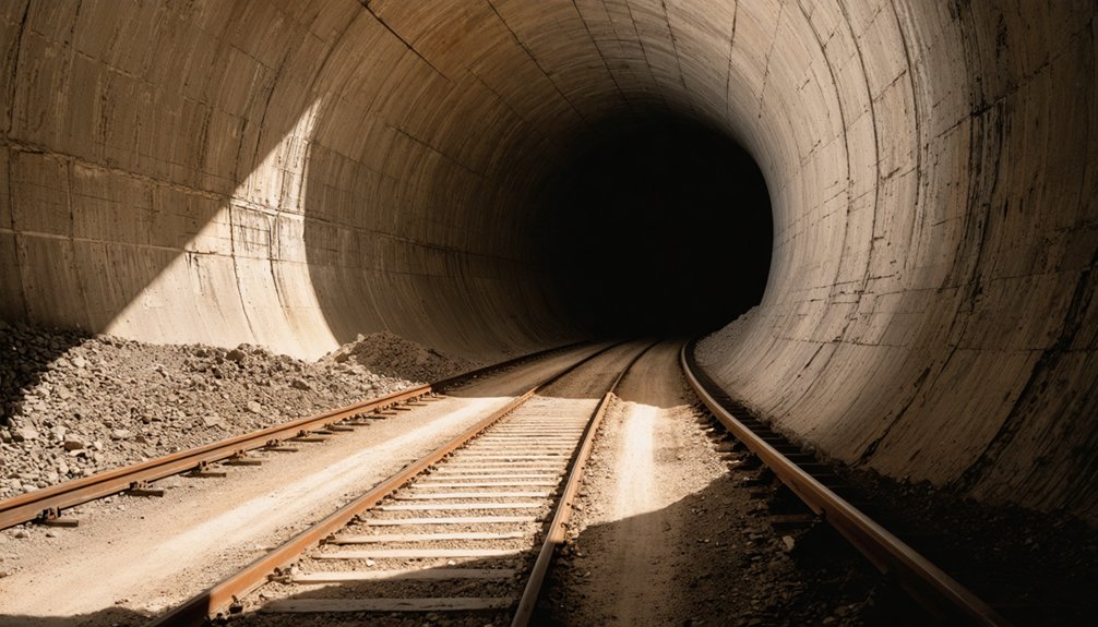
You’ll marvel at the 1939 tunnel system that Utah Copper built for $1.4 million—a curved, 7,000-foot passage carved through the mountain with steel-reinforced concrete and an arched ceiling soaring above the 12-foot-wide roadway.
The engineering showcased remarkable foresight: ceiling sensors monitored exhaust fumes while a massive 150,000 cubic foot fan pulled toxic air from the tunnel, and articulated doors at each portal could stop traffic when particulate levels spiked dangerously high.
As you enter this one-way passage that climbs 500 feet on a 6.4 percent grade, you’ll understand why travelers once gripped their steering wheels tighter, watching for the traffic control lights that governed their precarious journey between Bingham and Copperfield.
Tunnel Construction and Dimensions
Boring through solid rock at 6,100 feet elevation, construction crews broke ground on the Bingham Canyon Tunnel in March 1937, launching one of Utah’s most ambitious mining infrastructure projects. Working three shifts around the clock, teams excavated from both portals simultaneously, meeting precisely in the mountain’s heart by February 1939.
The tunnel dimensions revealed impressive engineering:
- Length: 6,698 feet (1.25 miles) cutting through solid rock
- Width: 12 feet 4 inches accommodating single-lane traffic
- Grade: 6.4 percent ascending 500 feet from Bingham to Copperfield
- Design: Steel-reinforced concrete with arched ceiling and elevated walkway
You’ll find this tunnel infrastructure cost $1,400,000—nearly triple initial estimates—under superintendent Paul Guinn’s direction. The 6.4-percent grade climbs steadily eastward, bypassing the expanding open pit mine.
Traffic Control Light System
When you peer into the tunnel’s entrance today, it’s hard to imagine the cutting-edge automation that once controlled traffic through this mountain passage. Back in 1939, this represented remarkable traffic control innovations—electric eye sensors detected approaching vehicles and triggered signal lights automatically, managing one-way flow in 20-minute cycles.
You’d have encountered signals at both portals and two internal turnouts, part of automated safety systems that included ceiling sensors monitoring exhaust fumes. When particulate levels spiked, a massive 150,000 cubic foot fan kicked in while articulated doors sealed the portals.
During system failures or summer congestion, watchmen stationed at each end communicated by telephone, manually operating lights or flagging vehicles through. It’s a forgotten chronicle to engineering ingenuity in remote Utah wilderness.
Daily Dangers and Risks
Behind those sophisticated traffic controls lurked genuine peril. Your journey through this mountain passage meant confronting suffocating ventilation risks in a confined 12-foot-wide tube. The 150,000 cubic foot exhaust fan represented your only defense against deadly fumes accumulating along that 6.4 percent grade.
Consider what you’d face daily:
- Exhaust accumulation from vehicles climbing the steep one-way route
- Sensor failures that could trap you in toxic conditions
- Zero escape routes along the elevated pedestrian walkway
- Complete isolation if ventilation doors closed during transit
The isolating mountain accessibility proved most troubling—after 1939, this became Copperfield’s sole access point. You’d risk everything on mechanical systems deep underground, with mine workings threatening structural integrity and no alternative paths to freedom.
Peak Era: Life at 6500 Feet With 2000 Residents
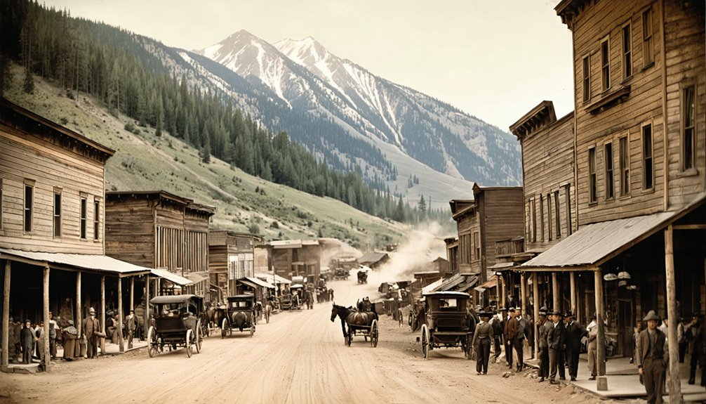
Perched between 6,500 and 7,000 feet above sea level, Copperfield clung to the mountainsides of Bear Gulch, where nearly 2,000 residents carved out lives in one of Utah’s most ambitious mining communities. You’ll discover this wasn’t some ramshackle camp—it was a cohesive mining community built purposefully for US&R and Utah Copper employees, complete with duplexes terraced into steep slopes and Terrace Heights’ surprisingly straight sidewalks.
The challenging alpine living conditions demanded resilience. Heavy winter snows buried homes, spring floods threatened foundations, and residents sheltered in wooden structures when blasting shook the mountainside. Yet proximity bred unity—housing clustered near work sites, kids attended the central elementary school, and neighbors banded together against weather’s fury. Life here meant embracing isolation and interdependence simultaneously.
Neighborhoods and Ethnic Camps of Old Copperfield
Beyond the unified image of a company town, Copperfield revealed itself as a patchwork of ethnic enclaves where immigrants from dozens of nations recreated fragments of home on Utah’s mountainsides.
Exploring Copperfield ghost town history provides insight into the diverse cultures that contributed to its unique identity. Each corner of the town tells a story, from the remnants of immigrant homes to the artifacts left behind in local businesses. This rich tapestry of past lives invites visitors to delve deeper into the shared experiences of those who once called this place home.
Cultural diversity shaped the canyon’s geography:
- Scandinavians claimed Carr Fork’s territory
- Southern and eastern Europeans congregated in Highland Boy’s branch canyon
- Copperfield occupied the upper mainstreet section
- Each neighborhood developed distinct churches, boarding houses, and social centers
This class stratification wasn’t accidental—mining companies often segregated workers by ethnicity, believing it prevented unified labor organizing. Yet these separate communities thrived independently, their saloons echoing different languages, their restaurants serving varied cuisines. You’ll find this ethnic mapping repeated throughout Western mining camps, where geography enforced divisions that couldn’t suppress immigrant resilience and cultural preservation.
The Evacuation Timeline From 1950 to 1958

You’ll notice the town didn’t vanish overnight—Copperfield’s end came through a gradual eight-year exodus as Kennecott Copper Corporation expanded its open-pit operations into the residential areas.
The mining company’s growing appetite for ore-rich land forced families to abandon their homes street by street, neighborhood by neighborhood, until the last residents packed their belongings in 1958.
Standing at the overlook today, you’re looking at a landscape where bulldozers and dynamite erased not just buildings, but the final chapter of a community that chose copper over continuity.
Mine Expansion Forces Residents
As Kennecott completed its $17 million Garfield refinery in 1950, the company set in motion a transformation that would erase entire communities from the canyon. The mine ownership impacts became undeniable as the pit expanded three-quarters of a mile deep, swallowing Copperfield and its neighboring settlements. You’ll find worker relocation challenges marked every phase of this expansion:
- 1948-1950: Kennecott shifted operations from steam to electric rail, signaling massive infrastructure changes
- 1950-1955: Complete evacuation of Copperfield’s alpine homes as open-pit mining overran residential areas
- 1958: Contractors removed waste from the pit’s high west side, widening operations further
- 1959: ASARCO smelter acquisition consolidated Kennecott’s control over the entire production line
The pursuit of copper left no room for the 3,000 people who’d called Bingham Canyon home.
Final Families Depart 1958
Between 1950 and 1958, Copperfield transformed from a bustling mountain community into an abandoned memory, its streets emptying in waves as Kennecott’s copper pit crept closer.
You’ll find this exodus wasn’t sudden—families left gradually as mine expansion swallowed homes and economic collapse causes relocation became inevitable. The writing was clear: stay and lose everything, or leave on your own terms.
Best Viewing Alternatives: Historical Photos and Virtual Tours
Since Copperfield’s physical landscape vanished decades ago, your window into this vanished mining community exists through carefully preserved photographs and digital reconstructions. You’ll discover past photographic archives at Utah State Historical Society and BYU Marriott Library, where Larry Sax’s collection captures everyday life from 1912 powder box houses through 1957’s final days.
For immersive video experiences, explore these essential resources:
- “Trip around Copperfield, Ghost Town” (13:39) chronicles the transformation from 1914 incorporation through 1958 demolition
- Footage showcasing the E-line Bridge’s evolution from observation platform to 1939 tunnel replacement
- Construction sequences of 1923-1924 brick cottages with over 100 workers laying foundations
- Colorized images revealing Greek and Japanese camps alongside Fellow Hall
These digital archives let you roam freely through Copperfield’s history without physical barriers.
Planning Your Trip to Nearby Copperton and Related Sites
While Copperfield exists only in photographs and memories, you’ll find its living counterpart just miles away. Copperton still stands where it began in 1926, showcasing remarkable copper architecture details—roofs, gutters, window frames, even complete prefabricated copper homes. You’ll spot design variations created by rotating floor plans across the grid that was built around a baseball diamond.
The town maintains its character through community traditions and events like Classic Car Shows featuring muscle cars and roadsters. Stop by Immaculate Conception Church, where 500 Vietnamese Catholics worship, reflecting Copperton’s continuing immigrant heritage. Don’t miss Kennecott Copper Mine‘s visitors’ center for stunning views of the massive excavation that consumed Bingham Canyon. This living mining town offers tangible connections to the vanished settlements that once dotted these copper-rich canyons.
Seasonal Considerations for High Elevation Canyon Exploration
The mountain canyons surrounding these historic copper mining sites demand respect for their dramatic elevation shifts and unpredictable weather patterns. You’ll navigate terrain where temperatures drop 3°F per 1,000-foot climb, transforming mild valley conditions into sub-arctic exposure above 11,000 feet.
Your timing matters greatly:
- Winter (December-March): Snowpack conditions accumulate beyond 55 inches at elevation, creating impassable roads and extreme cold reaching -50°F in severe years.
- Spring (April-June): Monitor spring runoff timing carefully—peak flows flood meadows and wash out canyon routes during May-June melt.
- Summer (July-September): Ideal access with warm temperatures, exceptional 10+ mile visibility, and low humidity around 20-30%.
- Fall (October-November): Brief window before snowfall returns; expect 32°F morning lows and increasing winds.
Frequently Asked Questions
What Permits or Permissions Are Needed to View the Kennecott Mine Area?
You’ll need purchased permits—$5 per person—to properly access this private property. Follow guidelines for accessing restricted areas by staying within fenced zones, using mandatory shuttles, and arriving before 2:30 p.m. for your overlook adventure.
Are There Any Copperfield Artifacts in Local Museums or Historical Societies?
You won’t find preserved mining relics from Copperfield in major museums. Historical documentation of Copperfield remains scarce in Utah’s collections. Check local historical societies near Tooele County—they occasionally preserve artifacts from lesser-known mining camps through private donations.
Can You See Remnants of the Tunnel Entrance From Public Viewpoints?
The tunnel’s swallowed by time’s hungry mouth—you won’t spot any remnants from public viewpoints. Tunnel entrance visibility is zero, regardless of seasonal accessibility. Mining operations erased everything, leaving only memories where Copperfield’s gateway once stood.
What Safety Precautions Apply When Visiting Active Mining Areas Near Bingham Canyon?
You’ll face strict access restrictions around active operations due to hazardous materials disposal and abandoned mine shaft safety risks. Stay outside permit boundaries, respect posted warnings, and never enter restricted zones—toxic releases and unstable ground make trespassing potentially fatal.
Are Guided Historical Tours Available for the Greater Bingham Canyon Region?
Yes, you’ll find guided bus tours departing Salt Lake City that cover Bingham Canyon’s mining history with live narration. Self-guided walking tours let you explore the visitor center and overlook independently, experiencing the canyon at your own pace.
References
- https://www.ghosttowns.com/states/ut/copperfield.html
- https://www.youtube.com/watch?v=Dimal7ZUEo4
- https://www.onlineutah.com/copperfieldhistoryb.shtml
- https://www.kennecott-groundbreakers.com/stories/the-bingham-to-copperfield-tunnel
- https://en.wikipedia.org/wiki/Bingham_Canyon
- https://www.youtube.com/watch?v=JGHAzW9-h1U
- https://onlineutah.us/copperfieldhistorya.shtml
- https://www.youtube.com/watch?v=GlZKMRyDbBA
- https://www.uen.org/utah_history_encyclopedia/c/COPPER_MINING.shtml
- https://www.mininghistoryassociation.org/Meetings/ParkCity2024/Bingham Canyon Orientation Guide FINAL AO31.pdf


