From Stanley, you’ll drive 11 miles northeast on ID-75 N before turning onto Yankee Fork Road, where pavement gives way to gravel as you wind through dramatic mountain vistas. This summer-only adventure (June-September) requires sturdy boots, layers, and plenty of water since you’re heading into true backcountry. Plan to base yourself in Stanley or camp nearby at Bayhorse, and arrive before the 5pm gate closure to explore weathered cabins, mining equipment, and the stories behind this 1879 boomtown’s rise and fall.
Key Takeaways
- Drive 11 miles northeast from Stanley on ID-75 N, turn left onto Yankee Fork Road, then travel 10 miles to Custer.
- Visit June through early September when tours operate and gates close at 5pm; winter conditions shut down all access.
- Explore the schoolhouse museum, historic cabins, Empire Saloon, blacksmith shop, and mining equipment scattered throughout the ghost town.
- Pack water, food, warm layers, and sturdy boots for this remote location with limited services and mountain weather.
- Extend your trip to nearby Yankee Fork Gold Dredge, General Custer Mine’s aerial tram, and Custer Cemetery.
Getting to Custer: Directions and What to Expect on the Journey
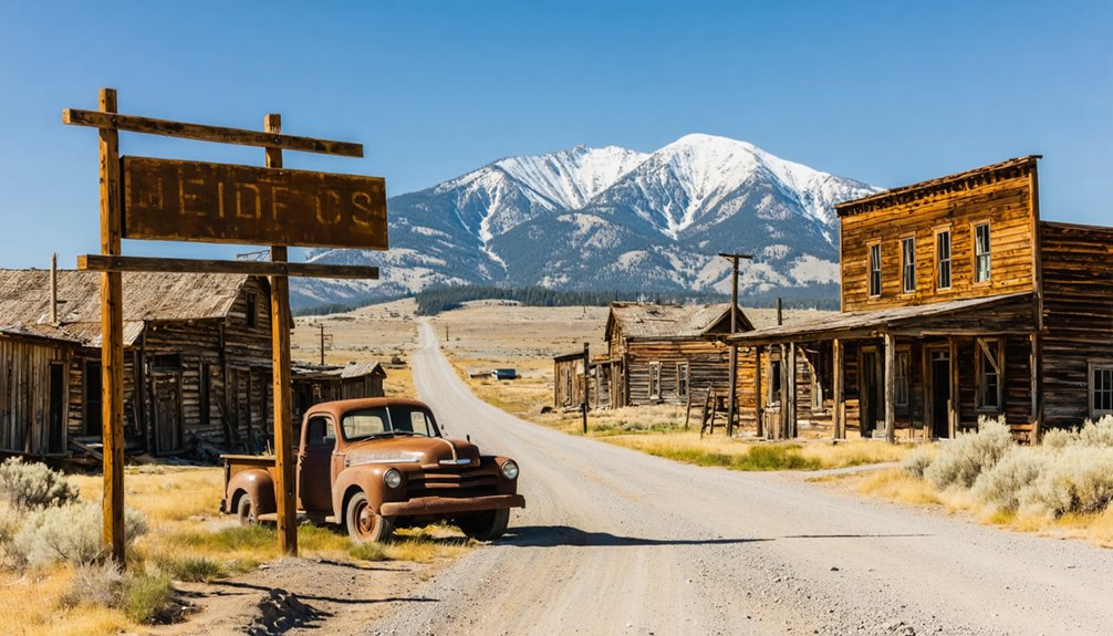
If you’re setting out from Stanley, the gateway to Custer couldn’t be more straightforward—just head north on ID-75 N toward Sunbeam, where the Salmon River carves through steep canyon walls and lodge pole pines crowd the roadside. Eleven miles northeast, you’ll spot the well-marked junction for Yankee Fork Road (Forest Road #013). Turn left and commit to ten miles of adventure: the first third rolls smooth on pavement before shifting to gravel that’ll test your sedan’s spirit but won’t break it. Road conditions stay manageable in dry summer months, though accessibility factors change dramatically after rain. The route follows the Salmon River Scenic Byway, offering dramatic mountain vistas as you wind deeper into the Sawtooth National Recreation Area. Watch for the semi-standing cabin secured by cables—your signal that Custer’s weathered storefronts await. Park at coordinates 44.387467, -114.696448, right next to the general store, and step into 1870s mining history.
The Wild History Behind Idaho’s Most Fascinating Mining Ghost Town
The story of Custer explodes in early 1879 when Sam Holman—a Harvard Law graduate who traded courtrooms for claim stakes—founded this scrappy settlement below the General Custer mill site, christening it after the doomed general whose massacre at Little Bighorn still haunted American newspapers.
A Harvard lawyer abandoned law books for mining claims, naming his wild settlement after America’s most infamous military disaster.
You’ll discover unique mining operations that transformed this mountainous wilderness into Idaho’s most ambitious frontier experiment, where a 20-stamp steam-powered mill and 3,200-foot aerial tram carved wealth from stubborn rock.
This distinctive cultural landscape thrived through brutal contradictions:
- Nearly 1,000 fortune-seekers crammed into five saloons and three boarding houses
- Stone cabins sheltered solitary miners while Chinatown bustled with immigrant laborers
- Avalanches claimed lives listed simply as “snowslide” in the cemetery
- No church ever rose, though whiskey flowed freely
The boom swelled Custer to 600 residents in 1896, outpacing its rival Bonanza downstream, before the Lucky Boy Mine and General Custer Mill shuttered in 1904, bleeding the town’s lifeblood away. While a handful of diehards clung to their claims, the last residents departed in 1910, sealing Custer’s fate as a ghost town.
Must-See Historic Buildings and Landmarks When You Arrive
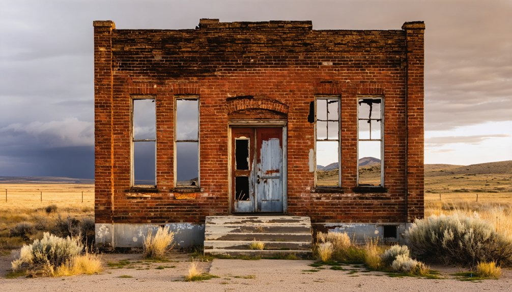
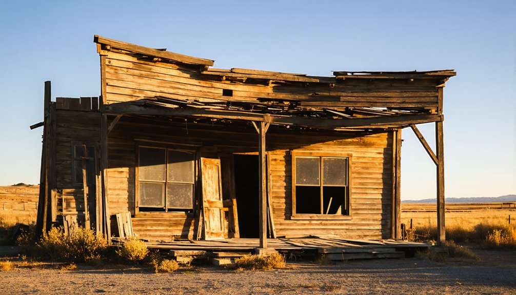
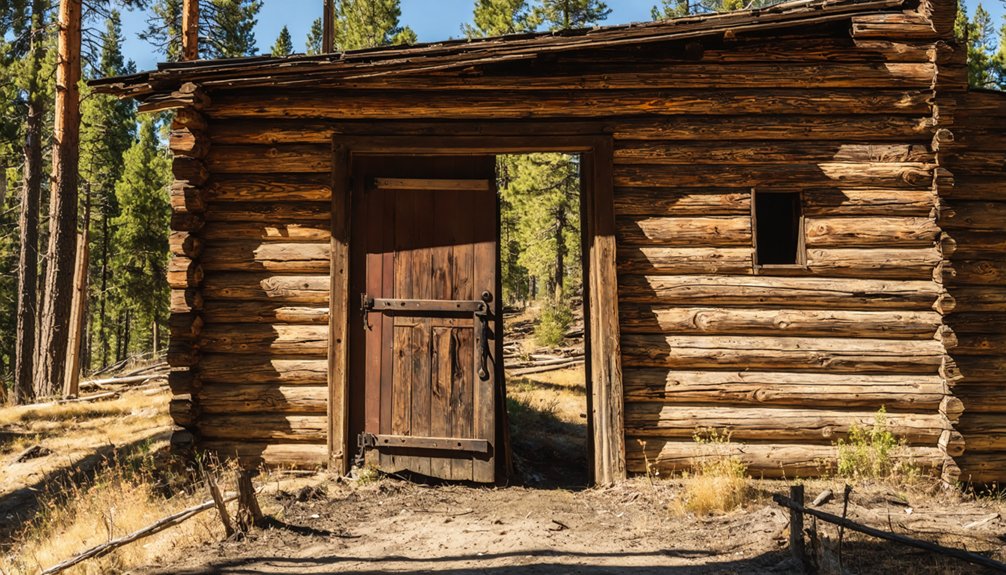
Standing amid weathered timber and rusted iron, you’ll find Custer’s remnants scattered across a high mountain meadow like artifacts from a fever dream.
Start at the Schoolhouse Museum, where original wallpaper still clings to walls that once echoed with children’s lessons and Saturday dances. Walk through authentic historic cabins where mining families weathered brutal winters in single-room dwellings—the furniture and wallpaper frozen in time.
The Empire Saloon stands ready with summer refreshments, while the blacksmith shop reveals an unexpected surprise: a dentist’s chair where the smithy pulled teeth between shoeing horses. Outside, massive sleds and mine carts rust in mountain grass, monument to backbreaking labor.
Follow trails connecting these structures, each preserved in partial disrepair—authentically conveying the harsh realities these pioneers faced. The site welcomes visitors 24 hours/day throughout the season, allowing you to explore at your own pace whether under morning sun or evening stars.
Exploring the Surrounding Area: Mines, Cemeteries, and Natural Wonders
Beyond Custer’s weathered buildings, networks of rusted machinery and tunnel openings scar the mountainsides where fortunes were won and lost. You’ll discover the General Custer Mine’s 3,200-foot aerial tram remains and the Yankee Fork Gold Dredge, which recovered $11 million before hitting bedrock in 1952.
The Clayton Mine’s massive tailing piles reveal roughly 1 million tons of unprocessed ore. Between 1927 and 1986, the mine extracted over 2 million tons of ore before closing due to low metal prices.
Notable exploration sites include:
- Custer Cemetery, where weathered headstones tell miners’ stories
- Boot Hill near Gilmore with three undisturbed burial sites from the 1880s
- Montana Mine’s exposed quartz veins, Idaho’s richest natural ore body
- Kinnikinic Creek slopes displaying significant lead-silver deposits
The Challis National Forest surrounds these mining operations, offering unrestricted access to authentic frontier remains within the 29-acre Historic Area. At an elevation of 6,470 feet, Custer’s high-altitude location provides sweeping views of the surrounding Custer County mining landscape.
Essential Tips for Your Visit: Seasons, Supplies, and Accommodations
After exploring abandoned shafts and weathered grave markers, you’ll need to plan strategically for Custer’s challenging environment and isolation. Check weather forecasts before departing—summers offer ideal visitor activities from June through early September, with temperatures reaching the 70s. Pack water, food, warm layers, and sturdy boots since you’re venturing into remote Sawtooth territory. Late September risks sudden snowfall that’ll strand you on gravel roads.
Base yourself in Stanley, thirteen miles away, where you’ll find lodging cheaper during shoulder seasons. Bayhorse sits seven miles from Challis if you’re camping. Remember, tours run summer-only, and gates close by 5pm. Winter’s brutal conditions shut everything down—those historic avalanches weren’t mere legends. The coldest month is December, when temperatures plummet to an average low of 16°F with highs only reaching 35°F. The Yankee Fork Gold Dredge stands as a popular attraction near Custer, offering insight into the mining operations that once drove the region’s economy. Time your escape for early June or late September for uncrowded exploration without winter’s grip.
Frequently Asked Questions
Are Pets Allowed When Visiting Custer Ghost Town?
Yes, you’ll find Custer pleasantly uncivilized about your four-legged companion—leashed dog policies apply on these historic grounds. Nearby pet-friendly accommodations welcome your adventure buddy, because freedom-loving explorers shouldn’t choose between ghost towns and their loyal trail partners.
Is There a Fee to Enter or Tour Custer?
You’ll pay nothing to explore Custer—no tour prices apply year-round. Free guided walks run during summer’s seasonal hours (Memorial Day through Labor Day), while self-guided adventures await whenever you’re ready to roam.
Can Visitors Enter the Historic Buildings or Just View From Outside?
You’ll freely wander through weathered wooden structures designated safe by park management. Guided tours available during summer reveal hidden histories, while preservation efforts ongoing maintain these treasured time capsules. Explore independently, respecting fragile buildings and posted boundaries protecting this authentic frontier experience.
Are the Old Mines Safe to Explore Without a Guide?
No, you shouldn’t explore old mines without guides. Potential tunnel instability, deadly gases, and unlicensed excavation risks make them extremely dangerous. Stick to Custer’s safe, marked trails where you’ll experience authentic history without risking your life.
Is Cell Phone Service Available in Custer and Surrounding Areas?
You’ll find cell service spotty as a patchwork quilt in Custer’s remote terrain. AT&T offers the best network coverage at 13%, while data connectivity remains limited throughout. Download offline maps and inform someone of your route before venturing out.
References
- https://www.wanderingidahoan.com/adventures/custer-city-ghost-town
- https://www.atlasobscura.com/places/custer-ghost-town
- https://www.fs.usda.gov/r04/salmon-challis/recreation/discover-history/custer-ghost-town
- https://www.islands.com/1748075/custer-ghost-town-wild-west-ghostly-charm-abandoned-idaho-timeless-beauty/
- https://kids.kiddle.co/Custer
- https://www.fs.usda.gov/r04/salmon-challis/recreation/custer-town-site-interpretive-site-major
- https://westernmininghistory.com/towns/idaho/custer/
- https://www.tripadvisor.com/Attraction_Review-g28933-d1775240-Reviews-Bonanza_and_Custer_Ghost_Town-Idaho.html
- https://www.mapquest.com/us/idaho/bonanza-and-custer-ghost-town-525860509
- https://www.onxmaps.com/offroad/trails/us/idaho/custer-ghost-town