Navigate to Damon using coordinates 44.4427°N, 84.1703°W in Ogemaw County‘s north-central wilderness, bringing GPS-compatible maps since cell service is nonexistent. You’ll discover the weathered 100-foot general store dominating the townsite, plus scattered foundations and remnants from this 1878 lumber settlement that peaked at 800 residents before trees ran out. Pack your bushwhacking gear to reach the sawmill foundation three miles east, and don’t miss Damon Cemetery half a mile south with its weathered gravestones. Understanding what made this place tick—and why James Oliver Curwood immortalized it—transforms scattered ruins into compelling narrative.
Key Takeaways
- Damon is located in Ogemaw County’s north-central Lower Peninsula near Rose City, West Branch, and Selkirk at coordinates 44.4427°N, 84.1703°W.
- Download GPS-compatible maps before visiting since cell service is unavailable in the remote area surrounding the ghost town.
- The 100-foot general store is the main structure, with other remnants including house foundations, warehouse traces, and the cemetery.
- Damon Cemetery lies half a mile south of town, while the sawmill foundation sits three miles east requiring off-trail hiking.
- Practice responsible exploration by leaving structures untouched, packing out trash, and wearing respiratory protection inside buildings.
The Rise and Fall of a Michigan Lumber Town
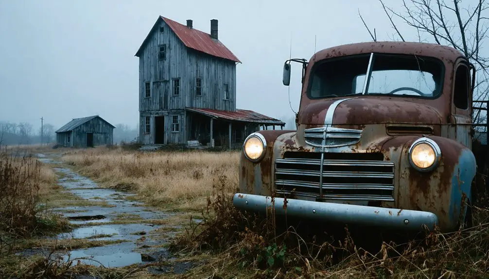
Deep in Michigan’s north-central forests, Damon sprang to life in 1878 as sawblades bit into virgin timber and George G. Damon’s firm carved civilization from wilderness. You’d have witnessed 800 souls thriving here by 1905—lumberjacks and merchants filling four blocks of businesses, a massive warehouse, and a 100-foot general store. Stagecoaches delivered mail while the hotel buzzed with activity. Ice-packed beef hung in the “refrigerator” building, oil fueled lanterns, and logging operations pushed deeper into green timber.
Then the trees ran out. Commercial decline arrived swiftly after 1900 as residents abandoned their frontier town. The post office shuttered in 1907, briefly flickered back in 1911, then died permanently in 1915. Author James Oliver Curwood immortalized this exodus, dubbing it the “Lost City of Damon” during his 1911 visit.
Where to Find Damon on the Map
Tucked into Michigan’s north-central Lower Peninsula, Damon occupies a remote stretch of Ogemaw County at coordinates 44.4427°N, 84.1703°W—a location that’ll require deliberate navigation rather than accidental discovery. You’ll find this hamlet marked on USGS 7.5-minute topographic maps at 1:24,000 scale, with current topographic maps from 2012-2014 showing precise terrain features including Wagon Wheel Hill (1,460 feet elevation) northwest of the settlement.
Historical cartographic records dating to 1965-1966 reveal how the landscape has transformed over decades. Reference nearby Rose City, West Branch, or Selkirk when planning your approach. Download GPS-compatible maps before departure—cell service won’t guide you through these backwoods. The Damon Quadrangle contains your destination, where civilization surrendered to forest regeneration.
James Oliver Curwood and the “Lost City of Damon”
In 1911, a journalist-turned-novelist stepped off the train into what most maps had already begun forgetting—and James Oliver Curwood saw literary gold in Damon’s abandonment. He dubbed it “The Lost City of Damon,” transforming the ghost of Michigan’s lumber era into something timeless.
Curwood’s inspiration for Damon emerged from that single visit, where empty buildings whispered stories of prosperity turned to silence. He’d already made his name chronicling Canadian wilderness adventures, but this decaying town offered something different—authenticity without traveling far from home.
Those fictional representations of Damon wouldn’t surface until “Green Timber” was published posthumously in 1927. You’re walking the same streets that sparked a bestselling author’s imagination, where reality and fiction blurred into one compelling narrative about frontier dreams.
What Damon Looked Like in Its Heyday
Standing at what was once Damon’s bustling center, you’d have witnessed four blocks packed with commercial enterprise—a warehouse measuring 50 by 80 feet anchoring one end, a 100-foot-long general store stretching along another. The population demographics reflected pure frontier grit: lumberjacks, their families, merchants, and travelers filling a hotel that never lacked guests.
Four blocks of frontier commerce: a massive warehouse, hundred-foot general store, and perpetually occupied hotel serving the lumber trade.
Behind the general store, an oil house dispensed fuel for logging camps, while a refrigerator building preserved beef sides using sawdust-packed ice blocks.
The economic impact rippled outward from a sawmill three miles east, its concrete foundation now hidden beneath decades of growth. Mail stagecoaches rattled through regularly, connecting this remote outpost to civilization.
A schoolhouse educated lumberjack children, while the post office—operating sporadically between 1880 and 1915—marked Damon’s official existence.
Exploring the Old General Store and Remaining Buildings
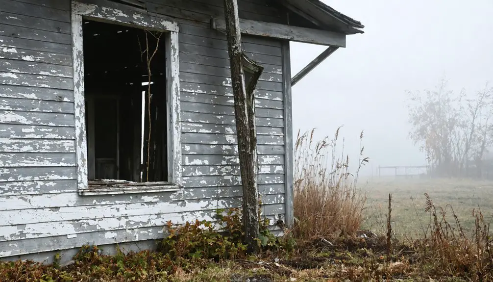
Today’s pilgrimage to Damon rewards the determined explorer with one predominant survivor: the old general store, standing defiant against a century of northern Michigan weather. You’ll find this 100-foot structure amid overgrown vegetation, its interior layout still hinting at the commercial activities that once drew customers from miles around.
A few weathered houses persist nearby, while concrete foundations hide beneath the underbrush.
What you’ll discover on-site:
- The general store’s weathered frame, where lumberjacks once purchased supplies and residents collected mail
- Traces of the post office that operated intermittently between 1880-1915
- Foundation remnants from the oil house, refrigerator building, and 50-by-80 warehouse that supported this four-block business district
These scattered remnants evoke Curwood’s “Lost City of Damon”—yours to explore freely.
Discovering Damon Cemetery’s Historic Markers
Just half a mile south of where downtown Damon once stood, you’ll find the cemetery resting quietly on the west side of Fairview and Turney Ranch Roads—one of the few remnants of this lumber town that still appears on modern maps. As you walk among the graves, you’ll discover an extraordinary mix of weathered wooden markers and marble tombstones dating back to the 1800s, their inscriptions documenting the lives of those who worked and died in this forgotten corner of Ogemaw County.
These original grave markers offer a tangible connection to Damon’s lumber era, standing as silent witnesses to a community that has all but vanished from Michigan’s landscape.
Original 1800s Grave Markers
Among the weathered monuments scattered throughout Damon Cemetery, you’ll discover original wooden grave markers from the 1800s that have somehow survived more than a century of Michigan’s harsh seasons. These ancient burial relics stand alongside marble tombstones, creating a haunting timeline of the lumber town’s forgotten residents. The weathered wooden inscriptions offer tangible connections to Damon’s obscure past, dating back to its lumbering heyday.
When exploring these historic markers, you’ll find:
- Rare wooden grave markers that few cemeteries still preserve in their original form
- Mixed materials showing the evolution from simple wood to ornate marble monuments
- Overgrown pathways leading to markers documented in online archives and Find a Grave records
Remember to respect these fragile pieces of history—they’ve endured this long through pure chance.
Cemetery Location and Access
Finding Damon Cemetery requires traversing a maze of dirt roads through Michigan’s Ogemaw State Forest, where most maps won’t even acknowledge the ghost town’s existence. You’ll need reliable GPS—these backwoods routes demand precision navigation. Head straight east from Higgins Lake, though geothermal mapping challenges and local forest conditions can confuse even modern technology. The cemetery sits half a mile south of where Damon’s downtown once thrived, on the road’s west side.
You’re entering genuine nowhere-land here, twelve miles north of West Branch in Foster Township. The isolation’s part of the appeal—no crowds, no restrictions, just you and Michigan’s forgotten history. Download topo maps beforehand and search “Damon Cemetery” or try Mapes Road coordinates. Most importantly, respect this remote sanctuary where marble and weathered tombstones tell stories the forest’s slowly reclaiming.
Searching for the Sawmill Foundation
Where exactly does one begin searching for industrial ruins swallowed by nearly a century of forest regrowth? Head three miles east from Damon’s dirt road intersection, then prepare to bushwhack through dense vegetation concealing concrete foundation fragments. You’ll need determination and patience—there’s no marked trail or visitor infrastructure guiding you to these remnants.
Your exploration strategy:
- Scan ground level systematically for concrete pieces hidden beneath underbrush
- Document discoveries through photography for historical documentation purposes
- Note any artifacts recovery opportunities while respecting archaeological preservation standards
These sawmill foundations represent Michigan’s 1865-1920 lumber industry that shaped Northern Lower Michigan’s settlement patterns. The site demands active searching through natural forest conditions, rewarding persistent explorers with tangible connections to Damon’s industrial heritage before timber depletion forced complete abandonment.
How to Get There: Route Options and Road Conditions
Getting to Damon requires traversing approximately 10 miles north from West Branch through Ogemaw State Forest‘s network of dirt roads—a journey that’ll test both your vehicle’s suspension and your wayfinding abilities. You’ll need GPS or detailed maps since this nowhere-land doesn’t appear on standard navigation apps.
Look for Damon General Store and the cemetery at 2535 McGregor Rd as your arrival markers. The dirt roads weave through terrain once alive with logging history, now silent except for weekend camping traffic. Friday afternoons bring caravans heading to nearby sites.
Two routes exist: a shorter developed path and longer back roads from old Dow Road. Respect this forgotten place—its wooden grave markers and whispers of local hauntings deserve your reverence, not vandalism or careless littering.
Best Practices for Visiting Ghost Towns

Once you’ve navigated those rutted forest roads and spotted Damon’s weathered structures through the pines, how you conduct yourself determines whether you’re an explorer or an intruder. Research legal permissions beforehand and consult historical archives to understand property boundaries—trespassing charges aren’t souvenirs you want.
The line between explorer and intruder isn’t marked by footprints—it’s defined by respect for boundaries and history.
Essential protocols for responsible exploration:
- Respect the silence – Skip the selfies and loud conversations; let Damon’s atmosphere speak through creaking timbers and wind-whispered stories
- Leave everything untouched – That rusted nail or weathered photograph belongs to history, not your collection
- Pack out what you pack in – Your trash bags prove stewardship over carelessness
Stay near structural supports inside buildings, carry proper respiratory protection against mold, and share your route plan with someone reliable. Freedom comes with accountability—explore thoughtfully.
Other Michigan Lumber Ghost Towns to Explore
While Damon offers solitude for those willing to venture off-grid, Michigan’s forests and coastlines conceal dozens of equally compelling lumber-era settlements where you’ll trade crowds for authenticity.
Port Oneida Village spans 2,000 acres along Sleeping Bear Dunes, preserving structures from the 19th-century boom when lumber transportation methods shifted from waterways to rail.
You’ll find self-guided tours at Central Mine in the Keweenaw Peninsula, where copper replaced timber as the economic driver before 1,200 residents dwindled to 100.
Delaware and Nonesuch exemplify the economic impact of industry decline—Upper Peninsula communities abandoned when resources vanished.
Each site offers unfiltered glimpses into Michigan’s extraction economy, where nature reclaims what isolation preserves. Bring your maps and independence; these destinations reward the self-reliant.
Frequently Asked Questions
Are There Any Facilities Like Restrooms or Water Available at Damon?
You’ll find absolutely nothing—public restrooms availability and drinking water sources are nonexistent in this forgotten wilderness. Pack everything you need before venturing out, because Damon’s remote location means you’re completely on your own for all essentials.
Is It Legal to Enter the Old General Store Building?
You’ll face uncertain legal standing entering the general store. No ownership details exist, but Michigan trespassing laws apply. Private property concerns remain unresolved, so you’re assuming trespassing risks. Stick to the cemetery and exterior exploration for safer, legally-clear adventuring.
What Time of Year Is Best for Visiting Damon?
Visit Damon between May and October when temperatures soar from 61°F to 83°F. You’ll find early spring blooms and accessible trails, while late autumn’s vibrant foliage creates an unforgettable, eerie backdrop for your ghost town exploration adventure.
Are the Dirt Roads Passable During Winter or Rainy Seasons?
Winter and rainy seasons present challenging road conditions with frozen ground preventing grading, impassable mud traps, and drainage issues. You’ll face potential hazards like concrete-like mud and delayed maintenance, making May-September your safest window for exploration.
Can I Camp Overnight Near the Ghost Town or Cemetery?
While Damon’s abandoned streets aren’t your campsite canvas, you’ll explore nearby camping options on state forest land instead. Respect private property boundaries around the cemetery, then pitch your tent legally one mile from established campgrounds.