You’ll find Doniphan’s haunting remains 5 miles northeast of Atchison, where weathered buildings scatter across windswept bluffs overlooking the Missouri River. Start at the intersection of Mineral Point and 95th Roads to explore the Brenner Vineyards Historic District, then visit St. John’s Catholic Church with its half-ton bell still hanging in the brick tower. Spring and fall offer ideal exploring conditions, though the abandoned settlement’s crumbling foundations and cemetery tell their melancholic story year-round. The complete journey through this landlocked port reveals how one catastrophic flood transformed prosperity into ghostly silence.
Key Takeaways
- Doniphan is located 5 miles northeast of Atchison, Kansas, at the intersection of Mineral Point and 95th Roads along the Missouri River.
- Visit the Brenner Vineyards Historic District to see the restored St. John’s Catholic Church, winery foundations, and weathered 1867 buildings.
- Plan your trip during spring or fall for moderate temperatures, or visit during shoulder seasons like March or December for lower costs.
- The 1891 flood left Doniphan landlocked, transforming this once-thriving river port into a 4.9-acre collection of historic structures.
- Combine your visit with nearby events like the Wathena Fall Festival or White Cloud Flea Markets for authentic local experiences.
The Rise and Fall of a Missouri River Trading Hub
Long before Doniphan became an organized town, traders recognized the strategic value of its rock-bound landing where the Missouri River curved along wooded bluffs. Joseph Robidoux established a post here in 1826 for Indian trade at Blacksnake mouth, followed by James F. Forman’s 1851 trading post and Josephus Utt’s riverside operation in 1852. The excellent landing attracted steamboat traffic, making it a boatmen’s landmark.
When the Doniphan Town Company organized in November 1854, settlement expansion exploded. Forman surveyed the townsite that spring, accepting payment in lots where he’d build his store. By April 1855, lots commanded $2,000 prices. Sawmills, dry goods stores, and lawyers arrived rapidly.
You’d have witnessed a thriving river hub—until June 1891’s devastating flood carved a new channel southward, leaving Doniphan landlocked beside what became Doniphan Lake, its prosperity swept away.
What Remains of Doniphan Today
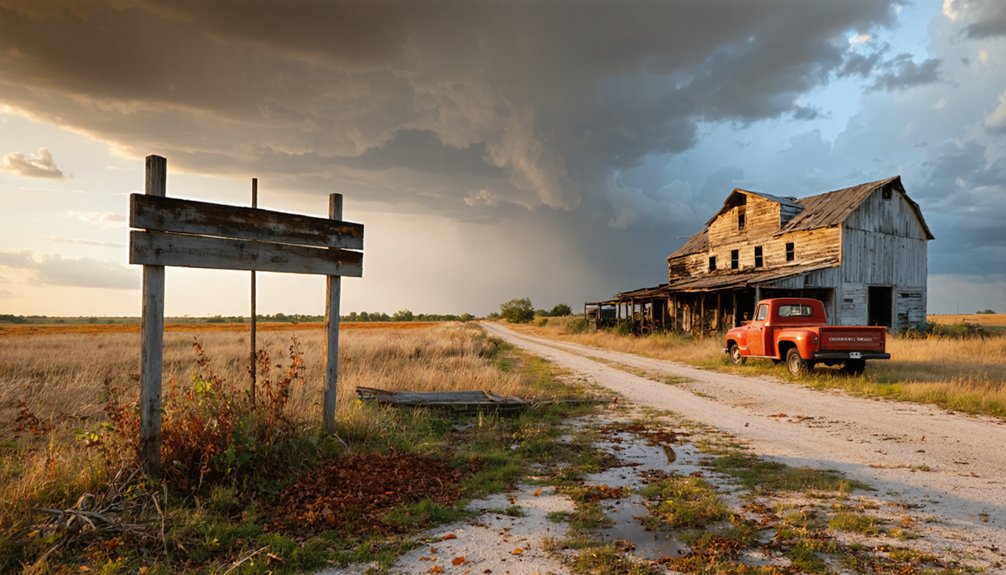
Today, Doniphan exists as a haunting collection of weathered structures scattered across 4.9 acres that tell the story of a once-thriving river town. You’ll find the Brenner Vineyards Historic District, listed on the National Register since 2005, where remaining historic buildings include a two-story winery, barn, corncrib, pump-house, and smokehouse. The restored St. John’s Catholic Church still hosts weddings and funerals, standing beside Adam Brenner’s house and winery ruins.
Beyond the historic district, you’ll discover old business buildings and homes in various states of decay. Contemporary cemetery usage continues at the nearby graveyard, serving the handful of residents who still call this area home. Where Doniphan Lake once surrounded the town, you’ll now find a large pool of water beside this isolated riverside ghost town.
Getting to Doniphan: Directions and Access Points
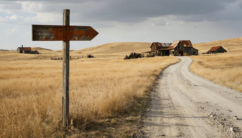
Tucked into the northeasternmost corner of Kansas, Doniphan sits approximately 5 miles northeast of Atchison along the winding Missouri River. You’ll find the historic district where Mineral Point and 95th Roads intersect—a spot that once served as an excellent rock-bound landing for steamboats.
From Atchison’s Riverfront Park, take River Front Road north for about 7 miles until you reach Mineral Point Road. This regional history overview reveals why settlers chose this location: abundant woods, running streams, and prime river access.
The early settlement timeline began with a trading post established in 1852 near the riverbank. Today, you’re following the same routes once traveled by stagecoaches running between Atchison and Topeka, where military convoys moved between frontier forts.
Best Time to Visit This Southeast Kansas Ghost Town
Your journey to Doniphan rewards careful timing, as Kansas’s four distinct seasons dramatically reshape the ghost town experience. Spring (April-June) and fall (September-November) deliver moderate temperatures perfect for exploring weathered structures and photographing transformed trees, though you’ll face higher accommodation costs.
Winter’s snow and summer’s heat push you toward indoor attractions at nearby museums, but shoulder season pricing considerations make March and December financially attractive. Weather impacts on accessibility considerably—the Missouri River’s historical flooding tendencies create muddy conditions that’ll challenge your exploration.
December offers holiday events and lower crowds, while March balances comfortable temperatures with reduced tourist demand. Time your visit around the Wathena Fall Festival or White Cloud Flea Markets for authentic local flavor without sacrificing your budget or freedom to roam independently.
Walking the Grounds: Key Sites and Landmarks to Explore
Once you’ve picked your season and arrived in Doniphan, the ghost town reveals itself slowly—not through bustling streets but through scattered remnants that demand your attention across farmland and quiet roads.
St. John’s Catholic Church anchors your exploration—its brick bell tower rises above the decay, housing a half-ton bell that once called worshippers.
Walk seven miles north from Atchison along River Front Road to Mineral Point Road, where the Brenner Vineyards Historic District spreads across 4.9 acres. You’ll find Adam Brenner’s 1867 elevator ruins, winery foundations, and weathered outbuildings that capture authentic ghost town ambiance. The cemetery still accepts burials, bridging past and present. These historic landmarks overlook the Missouri River from what Lewis and Clark noted as the finest landing above St. Louis.
The 1891 Flood That Changed Everything
Standing among the quiet bluffs, you’re witnessing the aftermath of a single June night in 1891 that severed Doniphan from its lifeblood.
The Missouri River’s sudden surge silted the railroad yards completely, then retreated southward to carve a new channel, leaving behind a four-mile lake where the town’s commercial artery once flowed. What had been a thriving grain-shipping hub with direct river and rail access became landlocked overnight, stranded on the wrong side of progress while rival towns flourished.
Railroad Destruction and Isolation
In early June 1891, heavy rains transformed the Missouri River into a devastating force that would seal Doniphan’s fate. You can imagine Superintendent Major Firth and secretary Mr. Allan surveying the wreckage—thousands of yards of track simply vanished, twisted metal disappearing into muddy torrents. The railroad infrastructure changes were swift and brutal.
Instead of rebuilding through Doniphan, the company relocated tracks two miles west, establishing Doniphan Station in its place.
This wasn’t the first abandonment—tracks had already shifted westward after the 1881 flood. But 1891’s destruction proved final. Without direct rail access, you’d have watched businesses shutter as commerce flowed toward Atchison and St. Joseph. The town’s economic decline accelerated rapidly, transforming this once-thriving river port into an isolated backwater, landlocked and forgotten.
Formation of Doniphan Lake
Saturday night, June 16th, 1891, brought the heaviest rainfall Doniphan County had ever witnessed. Every stream, brook, and rill overflowed, forcing the Missouri River into a catastrophic metamorphosis.
When the waters retreated, you’d have found an entirely new landscape—the river had carved a southern channel, abandoning its original course and leaving behind a four-mile-long lake stretching half to three-quarters of a mile wide.
Doniphan’s riverside identity vanished overnight. The town now sat landlocked beside what locals called “Doniphan Lake,” occupying the old river channel. Without natural shoreline stabilization, this wasn’t a stable recreational paradise—it was economic demise.
The ecological shift isolated the community, eliminating water transportation and burying railroad yards under thick silt deposits. You’re looking at geography’s power to erase human ambition in a single night.
Other Ghost Towns to Visit in Doniphan County
Doniphan County holds at least six other ghost towns within its borders, each with its own story of rise and abandonment. You’ll find Kickapoo and Iowa Point clinging to the Missouri River’s edge, Hickory Point scattered across farmland where Bleeding Kansas violence erupted, and Geary City’s vanished streets southeast of Troy.
Eagle Springs near Sparks offers the county’s most peaceful ruins, while Highland Station and Palermo round out your exploration of settlements that couldn’t survive the combined blows of war, floods, and economic shifts.
Highland Station and Palermo
Beyond Doniphan itself, two compelling ghost towns beckon explorers along Doniphan County’s weathered backroads. Highland Station—later renamed Sparks—sits 4.2 miles east of Highland along K-7’s Glacial Hills Scenic Byway. This railroad settlement peaked at 175 residents in 1910, boasting two churches, general stores, and a bank before its post office closed in 1971. Today, just nine souls remain among crumbling foundations that whisper of historical significance.
Further northeast, Palermo tells a starker tale. Born from 1850s stagecoach routes, it couldn’t survive transportation’s evolution. Failed 1920s revival attempts left nothing but memories. Both towns reveal the local impact of railway expansion and decline—their abandoned streets offering you authentic glimpses into Kansas’s frontier ambitions and inevitable transformations.
Planning Your County Tour
Your exploration of Doniphan County’s vanished settlements extends well beyond Highland Station and Palermo. Iowa Point, six miles north of Highland, once rivaled Leavenworth as the Missouri River’s second-largest city with over 3,000 residents before Civil War fighting reduced it to scattered foundations and a handful of weathered houses.
Several additional ghost towns await your discovery:
- Eagle Springs (3 miles north of Sparks) – peaceful abandonment with minimal ruins
- Geary City (6 miles southeast of Troy) – 260-acre townsite abandoned due to disputed land titles
- Sparks, New Norway, Moray, Denton, and Leona – Depression-era casualties
- Bendena – still-active community with 100 residents offering local resident history
County preservation efforts centered at St. John’s Catholic Church in Doniphan.
These settlements reveal Kansas’s boom-and-bust frontier patterns through crumbling foundations and forgotten crossroads.
Photography Tips for Capturing Historic Ruins
When light filters through shattered windowpanes and casts geometric shadows across warped floorboards, you’re witnessing the essential magic of ruin photography. Emphasizing architectural decay means capturing peeling paint, rusting metal, and nature’s relentless takeover—roots breaking through foundations, ivy claiming doorframes. Frame your shots using crumbling arches and collapsed staircases to create compelling compositions.
Utilizing natural light effects transforms ordinary scenes into extraordinary moments. Bracket your exposures to balance harsh contrasts, or turn away from light sources to photograph illuminated textures dancing across deteriorating walls. Early morning’s diffused glow works like a natural softbox, revealing details without harsh shadows. Try 10-20 second exposures with an ND filter to introduce ghostly cloud movement above static ruins, adding narrative depth to Doniphan’s forgotten structures.
What to Bring for Your Ghost Town Exploration

Before stepping into Doniphan’s decaying structures, pack essential gear that separates confident explorers from underprepared wanderers. Your high-lumen torch cuts through darkness where historic preservation efforts abandoned these relics decades ago. Steel-toe boots navigate debris-strewn floors where broken glass and rusty nails lurk.
Essential items for your exploration:
- Cut-resistant gloves for handling deteriorated surfaces
- Dust respirator against mold and airborne contaminants
- Thorough first-aid kit for unexpected injuries
- Multi-tool for clearing obstacles or emergency repairs
- EMF meter when documenting paranormal evidence
Don’t forget waterproof footwear for wet basements and a sturdy backpack to carry everything hands-free. Your camera captures crumbling facades while backup batteries guarantee you’re never left stranded in pitch-black corridors. Pack water and energy snacks—abandoned towns don’t offer convenience stores.
Frequently Asked Questions
Are There Any Guided Tours Available for Doniphan Ghost Town Visits?
No formal guided tours exist, but you’ll find freedom exploring self-guided walking tours through crumbling structures and weathered gravestones. Historical reenactments aren’t scheduled, so you’ll experience Doniphan’s haunting atmosphere authentically, wandering independently through forgotten streets.
Is Overnight Camping Permitted Near the Doniphan Ghost Town Site?
Camping isn’t currently permitted at Doniphan’s desolate grounds. You’ll discover nearby accommodations at Kansas state parks offering camping amenities within driving distance, where you’re free to pitch your tent under expansive prairie skies before exploring this abandoned settlement.
What Safety Precautions Should Visitors Take When Exploring Abandoned Structures?
Never enter abandoned structures—they’re dangerously unstable with collapsing floors and hidden hazards. If you’re viewing exteriors only, use sturdy footwear and avoid loose debris. Stay alert, respect boundaries, and prioritize your safety over exploration thrills.
Are There Any Local Museums Displaying Artifacts From Historic Doniphan?
Where else can history whisper its secrets? You’ll discover Doniphan artifacts at the Doniphan County Historical Society collections and Ma-Hush-Kah Museum. Don’t overlook private antique collectors who’ve preserved fragments of this vanished prairie town’s compelling story.
Do I Need Special Permission to Access Private Property in Doniphan?
Yes, you’ll need permission before exploring private property. Obtaining landowner consent protects you from trespassing liability concerns while accessing Doniphan’s ruins. The cemetery and church remain accessible, but surrounding farmland requires respectful contact with owners first.


