Planning a road trip to Drawbridge, California’s only wetland ghost town, means trading desert dust for tidal mud. You won’t find roads or trails leading to this eerie cluster of rotting cabins slowly sinking into San Francisco Bay’s southern marshes. Access is restricted within Don Edwards San Francisco Bay National Wildlife Refuge, so you’ll need binoculars and a spot near Alviso to glimpse its collapsing silhouettes. There’s far more to this haunting place than meets the eye.
Key Takeaways
- Drawbridge ghost town sits in the southern San Francisco Bay marshes, featuring decaying wooden cabins slowly sinking into tidal mud since its 1876 founding.
- Direct access to Drawbridge is illegal and restricted, as it falls within Don Edwards San Francisco Bay National Wildlife Refuge.
- An active Union Pacific Railroad line runs through the area, creating serious physical danger for anyone attempting unauthorized access.
- The best legal viewing option involves visiting trails near Alviso, where binoculars allow distant views of the abandoned structures.
- No roads or trails lead directly to Drawbridge, so plan your trip around wildlife refuge trails for safe, scenic marsh views.
What Is the Drawbridge Ghost Town in California?
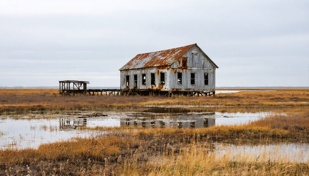
Tucked into the southern marshes of San Francisco Bay, Drawbridge is California’s only ghost town swallowed by wetlands — a cluster of rotting wooden cabins slowly sinking into the tidal mud on a nameless island.
Drawbridge history stretches back to 1876, when a single cabin sheltered a railroad drawbridge operator on what was then called Station Island. The South Pacific Coast Railroad transformed this remote outpost into a hunting and fishing retreat, drawing weekend crowds hungry for open water and wide skies.
At its peak, Drawbridge architecture included nearly 90 cabins and two hotels, many perched on stilts above the marsh.
Today, those same structures slump and decay, unclaimed by anyone — a raw, unfiltered snapshot of a place the modern world simply forgot.
Why Did Drawbridge Go From Boomtown to Ghost Town?
Drawbridge didn’t collapse overnight — it unraveled thread by thread, each loss pulling the next one loose.
The boomtown decline began quietly with dikes cutting off surrounding sloughs, causing the land to sink and forcing residents to dig deeper for fresh water. Environmental factors struck next — sewage from Bay communities fouled the water, and the ducks disappeared, gutting the town’s hunting identity.
Salt ponds arrived in 1936, poisoning what remained of the ecosystem. Then the Great Depression drained wallets, and when Prohibition ended, the homemade beer and outlaw mystique lost their pull. People simply stopped coming.
What Does Drawbridge Look Like Today?
What’s left of Drawbridge isn’t a town anymore — it’s a slow collapse frozen mid-fall. Abandoned structures lean into the marsh like exhausted travelers who simply stopped moving. Wooden walls have buckled, rooflines have caved, and the whole island tilts slightly, still sinking into the bay mud beneath it.
No roads reach it. No trails cut through. The wildlife refuge has quietly reclaimed everything around those rotting frames — egrets nest where hunters once drank homemade beer, and cordgrass swallows the spaces between what’s left standing.
You won’t walk the old streets or peek through doorways. You’ll view it from a distance, the way you’d observe something endangered — carefully, respectfully, knowing the marsh is finishing what the Depression and drained sloughs started decades ago.
Can You Actually Visit the Drawbridge Ghost Town?
Technically, no — you can’t visit Drawbridge, and the barriers aren’t bureaucratic suggestions you can reason your way around. The ghost town history you’re chasing sits locked behind two serious access restrictions: the Don Edwards San Francisco Bay National Wildlife Refuge and an active Union Pacific Railroad line.
Federal land means federal consequences. The railroad means physical danger. Both mean you’re turned back before you reach those slumping cabins.
Your best legal move is viewing from refuge trails near Alviso, where binoculars bridge the distance between you and the silhouettes of abandoned structures sinking slowly into marshland.
It’s frustrating, but that untouchable quality is part of what Drawbridge *is* now — a place that exists just beyond reach, disappearing on its own terms.
Where Can You Legally See Drawbridge?
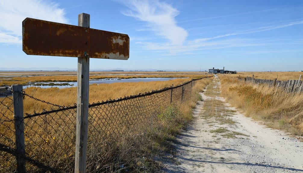
The closest you’ll legally get to Drawbridge is the network of trails winding through the Don Edwards San Francisco Bay National Wildlife Refuge near Alviso — a small, quietly weathered town at the southern tip of the Bay where the air smells of salt and decomposing marsh grass.
From these legal viewing points, you’ll scan the horizon for the slumped silhouettes of abandoned structures dissolving into wetlands.
From legal distance, you scan the horizon — searching for slumped silhouettes slowly dissolving into the indifferent wetlands.
The wildlife refuge frames your experience beautifully:
- Egrets stalking shallow water between you and the ghost town
- Rotting wooden walls barely visible above reed lines
- Union Pacific tracks cutting through silver-grey marsh flats
- Distant cabin shapes listing sideways like exhausted sentinels
- Open sky stretching uninterrupted over brackish sloughs
This is as close as freedom legally allows.
Frequently Asked Questions
What Year Did Drawbridge Officially Receive Its Unique Town Name?
With 90 cabins dotting its stilted landscape, you’ll find Drawbridge’s town name origins carry deep historical significance — it officially shed “Saline City” and embraced its iconic identity reflecting the hand-operated drawbridges that defined its character.
How Many Passenger Trains Served Drawbridge During Its Peak Years?
During Drawbridge’s peak, you’d have witnessed up to ten daily passenger trains roaring through, a tribute to its train operations and historical significance — five trains stopped daily, connecting free-spirited adventurers to this wild, untamed marshland escape.
Who Was the Very Last Permanent Resident to Leave Drawbridge?
Leaving behind silence, leaving behind history, Charles Luce was the last resident to walk away from this ghost town in 1979, closing the final chapter on Drawbridge’s once-vibrant, freedom-filled community.
Which National Wildlife Refuge Currently Protects the Drawbridge Ghost Town?
Don Edwards San Francisco Bay National Wildlife Refuge now shelters Drawbridge’s crumbling remnants, where wildlife conservation and historic preservation intertwine. You’ll find freedom’s echoes in these sunken structures, quietly reclaimed by marshland since 1972’s protective land transfer.
What Nearby Cities Can You Combine With a Drawbridge Road Trip?
Like magnets pulling you forward, Fremont and San Jose are your nearby attractions worth exploring. Weave through their scenic routes to uncover rich rail history that’ll deepen your Drawbridge ghost town road trip experience.
References
- https://en.wikipedia.org/wiki/Drawbridge
- https://cityofdust.blogspot.com/2016/01/my-mother-was-marshland-drawbridge-ca.html
- https://secretsanfrancisco.com/ghost-town-bay-area-drawbridge-history/
- https://www.atlasobscura.com/places/drawbridge
- https://www.sanjose.org/listings/drawbridge-formerly-saline-city
- https://www.youtube.com/watch?v=ttGi9F2MeWA
- https://www.kqed.org/news/11549263/the-island-ghost-town-in-the-middle-of-san-francisco-bay


