Planning a ghost town road trip to Enos, Illinois means trading smooth pavement for gravel roads cutting through Macoupin County’s rolling farmland. You’ll navigate with offline maps and a full tank, since services are scarce and cell signals fade fast. Watch for weathered fence lines, sunken foundations, and overgrown lots where a community once thrived. Visit during daylight, respect private property, and start early. Stick around, because there’s much more to uncover about making this forgotten place worth every mile.
Key Takeaways
- Enos is a ghost town in Macoupin County, Illinois, featuring weathered fence lines, crumbling foundations, and overgrown lots as historical remnants.
- Rural roads leading to Enos are 2WD-accessible but vary seasonally, so carry a paper map due to limited signage and services.
- Download offline maps, fuel up beforehand, and plan daytime visits to safely navigate areas with weak cell service and uneven terrain.
- Combine Enos with nearby Macoupin County ghost towns into one efficient route, starting early to maximize daylight and minimize backtracking.
- Research Enos using Ghosttowns.com, old plat maps, county histories, and the Illinois State Archives for a well-informed exploration experience.
What Is Enos, Illinois and How Did It Become a Ghost Town?
Tucked into the rural heart of Macoupin County, Illinois, Enos is one of those small settlements that quietly slipped off the map, leaving little behind but a name in a ghost-town directory and a grid coordinate to chase down on a country road.
Enos history traces back to a time when small Illinois communities rose around farming, rail stops, and post offices, only to fade as those foundations disappeared. Understanding these ghost town origins means recognizing a familiar pattern across central Illinois: when the railroad bypassed a town or the post office closed, people followed opportunity elsewhere.
What remained was silence, open fields, and a place name preserved in county records. For you, that’s not a dead end — it’s an invitation to explore.
Where in Macoupin County Is Enos Located?
Enos sits in Macoupin County, a stretch of central-southwestern Illinois where the land rolls out flat and quiet, far from interstate noise.
You’ll reach it by rural two-wheel-drive roads that cut through farming country, so expect narrow lanes, limited signage, and almost no services along the way.
It’s the kind of place you have to want to find, which makes spotting it on your road trip map feel like uncovering something the modern world simply forgot.
Macoupin County Geographic Position
Macoupin County sits in central-southwestern Illinois, and if you’re tracing Enos on a map, you’re looking at a rural stretch of countryside where old settlement patterns quietly faded over generations.
The county’s geographical features include rolling farmland, scattered timber, and creek drainages that once guided early settlers toward promising ground. That same terrain shaped which communities survived and which didn’t.
Enos fell into the latter category, becoming one of several settlements that lost their footing as transportation routes shifted and populations drifted toward larger towns.
Macoupin County carries real historical significance as a region that once hummed with agricultural ambition, railroad speculation, and frontier optimism.
Driving through it today, you feel that weight — a landscape that remembers more than its current quiet suggests.
Rural Road Access Details
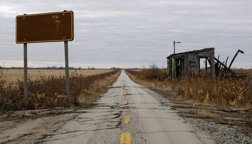
Finding Enos means committing to rural Macoupin County roads that don’t advertise themselves on major highway signs. You’re traversing lightly maintained two-lane stretches where gravel patches replace smooth asphalt and the landscape opens wide around you.
Ghost town accessibility here isn’t guaranteed — it shifts with the seasons, the weather, and how recently a county crew last graded the surface.
The ghosttowns.com directory rates Enos as a 2WD-accessible location, which means a standard vehicle handles the route under reasonable conditions. Still, you’ll want to check road conditions before you go, especially after heavy rain or winter snowfall.
Cell service thins out fast once you leave the main corridors. Carry a paper map, trust your instincts, and embrace the quiet isolation that makes this kind of road trip worth taking.
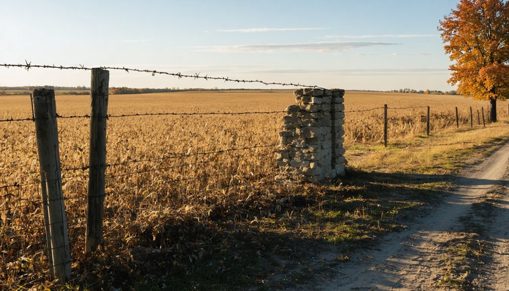
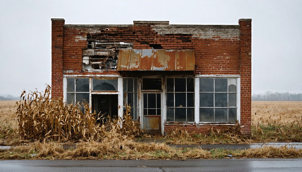
What Physical Remnants Survive at Enos Today?
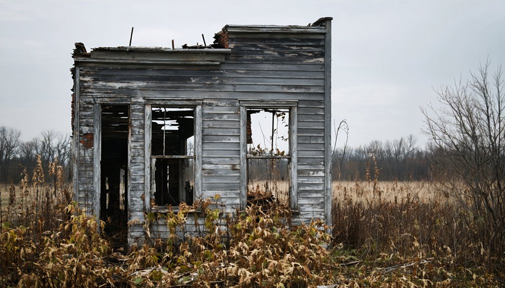
Once a living community tucked into rural Macoupin County, Enos today leaves few obvious traces for visitors who come searching. Your remnants exploration will likely turn up weathered fence lines, subtle depressions in the earth, and overgrown lots where structures once stood.
Enos barely whispers its presence anymore — just fence lines, quiet depressions, and overgrown lots where a community once breathed.
The historical significance of this quiet place hides beneath decades of tall grass and reclaimed farmland.
You’ll want to look carefully. A crumbling foundation, an old stone boundary, or a forgotten roadbed can speak volumes if you slow down and pay attention.
Bring a good map and sharp eyes, because Enos doesn’t announce itself. It rewards the curious traveler willing to piece together a vanished world from fragments the land hasn’t fully swallowed yet.
That quiet discovery is exactly what ghost-town road tripping is about.
How Do You Get to Enos on Rural Illinois Roads?
Getting to Enos means trading the interstate for two-lane blacktop and eventually gravel roads that cut through Macoupin County’s wide, quiet farmland.
Rural navigation here rewards patience and preparation. Before you roll out, lock in these three essentials:
- Download offline maps — cell service fades fast once you leave the main routes.
- Check road conditions seasonally — winter ice and spring mud can close lightly maintained county roads without warning.
- Note the 2WD rating — standard vehicles handle the route, but slow down on loose gravel.
Ghost town significance lives in the journey itself. You’ll pass old fence lines and forgotten field edges that hint at what Enos once was.
Arrive during daylight, respect property boundaries, and let the stillness do the talking.
What to Know Before You Drive Out to Enos
Before you point the car toward Macoupin County, a few practical realities will shape the whole trip. Cell service thins out fast on rural roads, so download your maps ahead of time.
Daytime visits are strongly recommended — Enos history doesn’t reveal itself well in fading light, and unlit gravel roads punish the unprepared. Winter snow can close access entirely, while summer heat turns the open fields brutal by midday.
Respect any posted property lines you encounter; ghost town legends grow around private land as much as public remnants. Carry water, keep your tank full before leaving a larger town, and tell someone your general route.
Freedom out here is real, but it rewards the traveler who plans honestly before leaving the pavement behind.
When Is the Best Time of Year to Visit?
Timing shapes everything on a ghost-town run, and Enos rewards the traveler who reads the calendar before reading the map. Seasonal weather in Macoupin County swings hard between extremes, so choosing the best visiting months matters more than most ghost-town stops.
Timing shapes everything at Enos — read the calendar before the map, or the county will read you.
- Spring (April–May): Mild temperatures, thawed roads, and quiet countryside make for ideal exploring before summer heat builds.
- Early Fall (September–October): Cooling air, harvest-season color, and firm rural roads give you the clearest, most atmospheric window.
- Winter (December–February): Snow closes access fast; cold snowy conditions turn a short detour into a stranded afternoon.
Pick spring or early fall, keep daylight on your side, and you’ll feel like the county belongs entirely to you.
What Other Macoupin County Ghost Towns Can You Add Nearby?

Once you’ve marked Enos on the map, Macoupin County pulls you deeper with a string of other forgotten settlements worth threading into the same day’s drive.
The county’s rural backroads connect abandoned settlements that once hummed with post offices, rail stops, and farming communities before quietly fading from the record.
Dig into county histories and old genealogy archives to surface those names — former crossroads villages where historic remnants might still stand as a weathered foundation, a lone chimney, or a forgotten cemetery half-swallowed by brush.
You won’t find signage pointing the way. That’s part of the draw.
Build your route loosely, leave room to stop when something catches your eye, and let the open road between these vanished places tell as much of the story as the stops themselves.
How Do You Build a One-Day Enos Road Trip Route?
Stringing those scattered Macoupin County ghost towns together into a single day’s drive turns a loose collection of map pins into something that actually feels like a journey.
Build your route with intention, and you’ll move through layers of Enos history without backtracking or burning daylight.
Build the route with care, and Enos history unfolds mile by mile, forward always, never back.
- Start early — rural roads reward morning light, and ghost town exploration demands good visibility over uneven terrain.
- Anchor Enos as your midpoint — approach from a neighboring ghost town, then push toward another after, creating natural narrative momentum.
- Pack self-sufficiency — fuel up before leaving any town with services, carry water, and download offline maps since cell coverage thins fast out here.
Let the empty roads do the storytelling.
You’re not rushing anywhere worth rushing to.
What Illinois Ghost Town Resources Help You Plan Further?

Planning deeper into Illinois ghost town country means leaning on resources that actually know where the bones are buried. Ghosttowns.com gives you a solid starting directory, including Enos itself, with road ratings and grid coordinates that matter when you’re traversing rural Macoupin County.
Supplement that with county-level histories, genealogy archives, and old plat maps that reveal vanished post offices and forgotten rail stops most travelers never find.
Illinois State Archives holds records that breathe life into names on a list. When your road trip appetite grows past Enos, those documents point you toward the next forgotten crossroads worth chasing.
Keep a printed backup ready because cell service gets thin fast out there, and freedom tastes better when you’re genuinely prepared to roam without depending on a signal.
Frequently Asked Questions
Is There a Fee to Access the Enos Ghost Town Site?
No fee stands between you and a world of ghost town history! You’ll roam freely, chasing local legends across Enos’s rural roads — just respect private property boundaries and let your adventurous spirit guide you.
Are Guided Ghost Town Tours Available in Macoupin County?
Guided tours aren’t widely advertised in Macoupin County, but you’ll uncover rich ghost town history and haunting local legends by exploring independently, tracing forgotten roads where free spirits once built whole communities that time quietly swallowed.
Can You Camp Overnight Near the Enos Ghost Town Location?
“Home is where you pitch your tent.” You’ll want to check local camping regulations, as no designated sites sit directly near Enos, but nearby attractions in Macoupin County offer rustic overnight options worth exploring.
Are Photography Permits Required When Visiting Illinois Ghost Towns?
You don’t typically need photography permits at Illinois ghost towns, but you’ll want to honor photography ethics and historical preservation by respecting private property boundaries and capturing these forgotten, evocative remnants of freedom responsibly.
Does Enos Ghost Town Appear on Official Illinois State Maps?
Like a whisper lost to time, Enos likely won’t appear on official state maps. Its historical significance lives in ghost-town directories instead. Start your urban exploration journey there — you’ll uncover forgotten freedom on rural Macoupin County’s open roads.
References
- https://blueridgemuse.com/node/13117
- https://www.youtube.com/watch?v=jf0w1u5vh8w
- https://m.hauntedillinois.com/realhauntedplaces/altons-haunted-hill.php
- https://en.wikipedia.org/wiki/List_of_ghost_towns_in_Illinois
- https://www.distilledhistory.com/hauntedalton/
- https://epnia.com/history-and-development-of-the-enos-park-area/
- https://www.ghosttowns.com/states/il/enos.html
- https://www.facebook.com/decayingmidwest/posts/ghost-town-in-illinois-with-almost-no-residents-cars-and-everything-left-behind/725728546627443/
- https://www.instagram.com/reel/DT16Hfmjnlt/
- http://genealogytrails.com/ill/jefferson/ghostowns.html