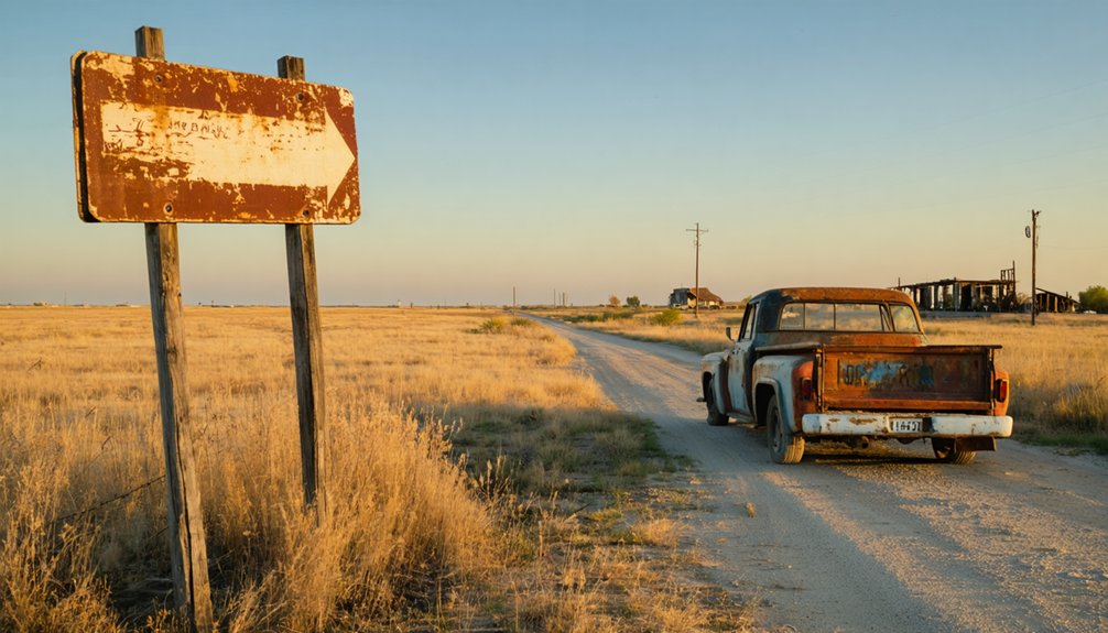
You’ll find Fame just a short drive from Picher, Oklahoma—perhaps the most haunting ghost town in America’s heartland. While Fame itself disappeared decades ago, the real destination is Picher, sitting eight miles southeast of Commerce, where 200-foot chat piles loom over empty streets the government paid everyone to abandon. The toxic legacy of lead and zinc mining left 450 open shafts and contaminated soil so dangerous that exploring requires serious safety precautions, from respirators to constant vigilance for sinkholes that could swallow you whole.
Key Takeaways
- Picher is located in the Tri-State Mining District near Cardin and Hockerville, all abandoned due to environmental contamination.
- Bring a respirator to protect against toxic lead-zinc dust from 200-foot chat piles scattered throughout the area.
- Avoid the 450 open mine shafts and sinkholes; the ground beneath 86% of structures is hollow with tunnels.
- Do not enter buildings as they have a 90% collapse risk and contain lead contamination from orange-stained surfaces.
- No residents remain after the 2009 federal buyout, and authorities do not control access to the ghost town.
The Rise and Fall of a Mining Boomtown
In 1913, Harry Crawfish struck something that would transform northeastern Oklahoma’s prairie into one of America’s most productive mining centers. Lead and zinc deposits drew fortune-seekers by the thousands, and Picher exploded overnight from empty claim to incorporated town by 1918.
You’d have witnessed rapid industrialization at its most raw—248 mills grinding ore day and night, trolleys shuttling 14,000 miners from neighboring cities, and $20 billion worth of metal pulled from the earth between 1917 and 1947.
But freedom came with a price. Labor exploitation ran rampant in those shafts, and when the ore finally ran dry in 1967, the town collapsed as fast as it’d risen. Workers fled, businesses shuttered, and Picher’s population plummeted from its 1926 peak of 14,252 to barely 2,553.
Environmental Catastrophe and Health Crisis
Everything the miners left behind became poison. You’ll find Fansteel’s radioactive waste still seeping into groundwater, threatening the Arkansas River from 105 contaminated acres.
Tar Creek runs orange with acid mine drainage—300-foot-deep shafts left unsealed, aquifers refilled with toxic waste. Those 200-foot chat piles? They’re not just landmarks. Wind carries their lead-zinc powder straight into your lungs, just like it did to Picher’s children in the 1990s when doctors discovered blood lead levels high enough to cause neurological damage.
Groundwater contamination turned Grand Lake, a drinking water source, into a toxic endpoint. The human health impacts hit hardest on Cherokee, Quapaw, and Ottawa lands—kids playing in yards where contaminated fill from old smelters poisoned the soil beneath swings and sandboxes.
The Federal Buyout and Mass Evacuation
The damage became so severe that officials finally admitted what residents had known for years—nobody should be living here.
In 2009, the federal government allocated $46 million to buy out Picher, Cardin, and Hockerville properties. The Lead-Impacted Communities Relocation Assistance Trust managed the program, offering an average of $65,624 per property. Buyout eligibility criteria covered 878 residential properties, with 96% accepting the offer to escape.
What Remains in Modern-Day Picher
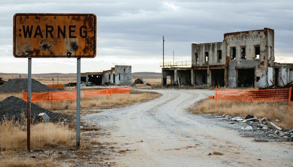
What’s left of Picher today resembles a post-apocalyptic film set more than a once-thriving mining town. You’ll find the abandoned Picher-Cardin High School, a standing Christian church, and the vacant mining museum among scattered mercantile buildings. Desolate residential areas stretch across empty neighborhoods that once housed 14,000 souls during the 1920s boom. A small memorial and the Gorilla mascot statue—commemorating the 1983 state football champs—serve as lonely monuments to community pride.
The area remains part of the Tar Creek Superfund Site, with ongoing Quapaw remediation efforts tackling lead, zinc, and cadmium contamination across 25,000 acres. Despite $600 million spent over 40 years, full cleanup won’t arrive for another 50 years. Zero residents remain to witness the transformation.
Exploring the Chat Piles and Abandoned Mine Shafts
The chat piles tower above Picher like monuments to a century of extraction—some reaching 200 feet tall, their gray-white slopes visible for miles across the Oklahoma prairie. You’ll find approximately 30 of these contaminated mountains scattered around town, still leaching lead and zinc into the soil despite decades of Superfund remediation that’s cost over $300 million.
Before you venture close, understand that 450 open mine shafts remain hidden throughout the area, and the ground beneath 86% of former structures sits hollow with tunnels that could collapse without warning.
Scale of Mining Devastation
Standing at the edge of a chat pile today, you’ll grasp the true enormity of Oklahoma’s mining legacy—72,000 acres transformed by human ambition and industrial hunger.
The numbers tell a stark story of extraction’s price:
- 32,000 acres stripped bare by surface mining operations that devoured the landscape
- 40,000 additional acres honeycomb with underground tunnels beneath your feet
- 25 distinct coalbeds systematically excavated across eastern Oklahoma’s 12,000 square miles
- Peak production of 6 million tons in 1981, now collapsed to mere thousands
- 342 million tons still buried below, untouched reserves bearing witness to boom and bust
These reclamation challenges persist decades after abandonment. The long-term environmental impact sprawls across 15 counties—a record/chronicle/documentation to industry’s appetite and nature’s patience.
Safety Hazards to Consider
Beyond the haunting beauty of Fame’s industrial ruins lurks a catalog of deadly hazards that’ve claimed 26 lives on Oklahoma’s abandoned mine lands since 1972. You’re stepping onto 70,000 acres where highwalls collapse without warning, water-filled pits conceal rusted machinery beneath contaminated surfaces, and subsurface voids threaten cave-ins from mere footsteps. Those towering chat piles? They’re 70 million tons of lead-contaminated tailings that’ll coat your lungs with toxic dust.
Despite minimal abandoned mine inspections and murky liability for mine hazards, you’re free to explore—but that freedom comes with consequences. Oxygen-deficient shafts have killed would-be rescuers alongside their victims. The thrill of discovery here demands respect for industrial-scale danger. Tread carefully, bring backup, and understand you’re gambling against geology itself.
What Remains Today
Seventy million tons of crushed rock waste tower over Fame’s landscape like man-made mountains, their rusty-orange slopes glowing almost crimson at sunset. These chat piles create extraordinary exploration opportunities you won’t find anywhere else.
Driveable roads circle their bases, letting you witness industrial-scale devastation up close while seeking out vertical mine shafts hidden in overgrown fields nearby.
What You’ll Encounter:
- Chat pile summits reaching 100-200 feet with panoramic views across Ottawa County’s ghost towns
- Fenced vertical shafts dropping 100-500 feet into darkness, often marked only by rotting timber
- Surface subsidence depressions up to 50 feet wide from collapsed underground ceilings
- Abandoned mining equipment rusting among Fame’s smaller zinc mounds
- Eerie photographic experiences along Highway 69 where orange tailings meet apocalyptic skies
These landmarks define northeastern Oklahoma’s haunted mining legacy.
Safety Precautions for Visiting Picher
While Picher’s abandoned streets might beckon curious travelers, the ghost town presents serious hazards that demand careful preparation. You’ll need to stay on the main road—authorities aren’t controlling visitor access much, but 450 open mineshafts and countless sinkholes make wandering deadly.
The wind carries toxic dust from chat piles across town, so skip the motorcycle helmet for a respirator instead. Those orange-stained buildings? That’s lead contamination, not rust. Don’t touch anything, and definitely don’t kick up dust while exploring on foot. The Army Corps found 90% of structures face collapse risk, so admire them from your vehicle.
Monitoring toxic dust levels isn’t happening here—you’re on your own. Stay alert, respect the fences, and remember: Picher’s freedom comes with consequences.
Nearby Ghost Towns Worth Adding to Your Route
Just a few miles north of Picher, you’ll find Cardin, another casualty of the Tri-State Mining District where chat piles still loom over abandoned streets and toxic groundwater has driven away all but the most stubborn holdouts. The eerie orange-stained creeks and crumbling mine structures tell the same poisoned story as Picher, making this a sobering double feature of environmental devastation.
Continue north into Kansas and you’ll reach Treece, a ghost town literally split by the state line, where residents on both sides abandoned their homes when the ground beneath them began to collapse into maze-like mine shafts.
Cardin’s Toxic Mining Legacy
Unlike most ghost towns that fade slowly into obscurity, Cardin met its end through a federal death sentence—a $60 million buyout that erased an entire community from the map.
Once the world’s largest lead and zinc producer, decades of corporate greed left behind a poisonous wasteland. By 1983, extensive contamination earned Tar Creek Superfund designation, but the damage was irreversible. The public health consequences were devastating—lead-poisoned children, contaminated air, and ground ready to collapse from underground mining voids.
When you visit today, you’ll find:
- Fenced-off zones marking hidden mine shafts
- Skeletal remains of processing plants
- Empty lots where 2,640 residents once lived
- Contaminated dust still coating the landscape
- Federal warning signs throughout the abandoned streets
The last resident accepted the buyout in 2010, choosing survival over heritage.
Treece Straddles State Line
Cross the Kansas border and you’ll find Treece, Cardin’s twin tragedy straddling the state line. This ghost town faced identical state border challenges—EPA contamination rulings that ignored arbitrary political boundaries. The small town local dynamics mirrored Picher’s collapse: 138 residents dwindled to nearly zero by 2013 as chat piles poisoned everything. Kansas officially disincorporated Treece that year, erasing it from maps entirely.
You’ll discover foundations where homes once stood, streets surrendering to prairie grass. Two holdouts refused the buyout—defiant until the end. The same Tar Creek that contaminated Cardin flows through here, carrying decades of mining sins. Kids got chemical burns swimming in these waters, yet families stayed until staying became impossible. Drive slowly; you’re witnessing how industrial progress devours communities, leaving only toxic memories behind.
Getting There and Best Times to Visit

Finding your way to the ghost town of Shamrock in Cushing, Oklahoma, is invigoratingly straightforward—no dusty treasure maps required. From Oklahoma City, you’ll cruise 50 miles northeast via US-33 E, while Tulsa travelers take OK-51 W for about 60 miles. The scenic rural landscapes unfold across central Oklahoma’s plains, with proximity to nearby attractions like Ingalls and Skedee ghost towns enriching your adventure.
As you continue your journey exploring ghost towns to explore in Oklahoma, each stop offers a glimpse into the rich history and stories of the past. The remnants of these once-thriving communities reflect the spirit of adventure that defines the Sooner State. Don’t forget to capture the unique charm and eerie beauty of these locations as you wander through their silent streets.
Timing your escape:
- Spring (March-May): Wildflowers frame empty streets; temperatures hover between 50-75°F
- Fall (September-November): Crystal-clear skies perfect for photography; comfortable 40-70°F range
- Avoid summer’s 90°F+ heat that transforms exploration into endurance
- Skip tornado season (April-June) for safer wandering
- Weekday visits guarantee solitude among the abandoned structures
Travel time runs roughly an hour from either city—just enough distance to feel genuinely removed from civilization.
Frequently Asked Questions
Are There Any Hotels or Accommodations Available Near Picher, Oklahoma?
You’ll find hotels in nearby Miami, Oklahoma and Joplin, Missouri—ghost towns don’t exactly attract Hiltons. Consider bed & breakfasts like Rose Cottage or private vacation rentals for authentic stays while exploring Picher’s eerie, abandoned streets.
Can I Take Souvenirs Like Rocks From the Chat Piles?
No, you can’t take chat pile rocks—they’re federally protected and toxic. Despite their historical significance of chat piles, the environmental impact of chat piles makes them dangerous souvenirs. You’ll face hefty fines and serious health risks from lead contamination.
Is It Legal to Enter the Remaining Buildings in Picher?
You’d be playing Russian roulette entering Picher’s crumbling buildings—it’s illegal and dangerous. Potential environmental hazards include toxic dust and mine shaft collapses. Safety precautions for exploration? Don’t go inside. Admire from outside, breathe freely, leave alive.
Do I Need Special Permits to Visit or Photograph Picher?
You don’t need permits to visit Picher’s main roads, but you’re venturing into a Superfund site with potential environmental hazards. Photographing from public areas is fine, though risks of trespassing apply if you enter fenced properties or abandoned buildings.
Are Guided Tours of Picher Available for Visitors?
No guided tours are available for Picher—you’re on your own exploring this toxic ghost town. Tour schedules vary nowhere because none exist. You’ll navigate crumbling streets independently, surrounded by towering chat piles and eerie abandoned structures at your own risk.


