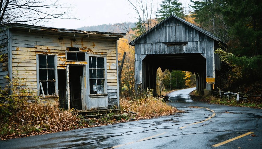
Glastenbury, Vermont isn’t your typical road trip destination — there are no welcome signs, no shops, and no living residents waiting for you. This former logging settlement was unincorporated in 1937 and swallowed by wilderness, leaving behind only cellar holes, charcoal kilns, and an eerie silence. It’s also ground zero for the mysterious Bennington Triangle disappearances. Start your drive north on Route 9 from Bennington, and stick around — there’s far more to this haunted ghost town than meets the eye.
Key Takeaways
- Glastenbury, not Florentine, is Vermont’s notable ghost town, spanning 36 square miles of Green Mountain wilderness with abandoned cellar holes and charcoal kilns.
- Drive approximately 20 minutes from Bennington heading north on Route 9, then turn onto Hell Hollow Road into Green Mountain National Forest.
- Visit between late spring and early fall for optimal hiking conditions, wildflowers, long daylight hours, or Vermont’s stunning autumn foliage.
- Pack a topographic map, compass, headlamp, first aid kit, sturdy boots, and sufficient water for safe exploration of the rugged terrain.
- Inform someone of your exact route and expected return time, and arrive early to maximize daylight for exploring hidden ruins safely.
What Makes Glastenbury a True Vermont Ghost Town?
When most people picture a ghost town, they imagine dusty streets and tumbleweeds in the American Southwest — but Glastenbury, Vermont tells a wilder, darker story. Tucked inside 36 square miles of unbroken Green Mountain wilderness, this former logging and charcoal-producing settlement collapsed after industry faded and a devastating 1898 flood erased its last economic hope.
You won’t find preserved storefronts here. Instead, you’ll walk through abandoned landscapes of crumbling cellar holes, silent charcoal kilns, and roads the forest has quietly swallowed whole. The state legislature formally unincorporated the town in 1937, making its ghost status official.
Glastenbury folklore deepens the mystery further — five unexplained disappearances between 1945 and 1950 earned this mountain a reputation that no amount of wilderness beauty can fully shake.
The Dark History Behind the Bennington Triangle
Few place names in New England carry as much dread as the Bennington Triangle — a stretch of southern Vermont wilderness centered on Glastenbury Mountain where five people vanished without explanation between 1945 and 1950.
Mysterious disappearances began with Middie Rivers in 1945, followed by Paula Welden in 1946, a young woman in red who simply walked around a trail bend and never returned. Her case directly prompted Vermont to establish its state police force.
Haunted legends predate even these vanishings — Abenaki people avoided the mountain entirely, warning of a man-eating stone and strange winds.
Long before the disappearances, the Abenaki refused to set foot on Glastenbury Mountain — and for good reason.
Locals reported unidentifiable sounds, eerie lights, and Bigfoot-like creatures dating back to 1879. You’re free to dismiss these stories, but the missing people remain stubbornly unaccounted for.
The Five Disappearances That Made Glastenbury Famous
Between 1945 and 1950, five people vanished without a trace in and around Glastenbury Mountain, cementing the region’s eerie reputation as the Bennington Triangle.
You’d recognize the most famous case — Paula Welden, a young hiker in a bright red parka, disappeared on the Long Trail in 1946 so inexplicably that her case directly prompted Vermont to establish its first state police force.
The first to vanish was Middie Rivers in 1945, the only disappearance officially documented within the town itself, and his fate, like the others, remains unsolved to this day.
The Vanished Five Victims
Perhaps no stretch of Vermont wilderness has swallowed people quite like Glastenbury Mountain did during a chilling five-year window from 1945 to 1950.
Five vanished victims left behind nothing but questions and cold trails.
Middie Rivers disappeared in 1945, the only case directly documented within town limits. A year later, Paula Welden — wearing a bright red jacket — vanished nearby, her eerie disappearance shocking enough to trigger the creation of Vermont’s state police force.
At least three more hikers followed, each disappearing within this same unforgiving mountain terrain.
These eerie disappearances earned the region its haunting nickname: the Bennington Triangle.
You won’t find easy answers walking these trails — just dense forest, unsettling silence, and the weight of stories that never found their endings.
Bennington Triangle Mystery
The Bennington Triangle isn’t a place you’ll find on any official map — it’s a name earned through blood, mystery, and five vanishings that shook Vermont to its core.
Between 1945 and 1950, five people disappeared without explanation near Glastenbury Mountain, fueling ghost stories that still circulate today.
The cases share eerie similarities:
- Middie Rivers vanished in 1945, leaving no trace
- Paula Welden disappeared in 1946, her red jacket swallowed by wilderness
- Paranormal sightings — strange lights, unidentifiable odors — followed each disappearance
No bodies. No answers. Just silence.
This unsettling pattern ultimately prompted Vermont to establish its state police force.
When you walk these trails, you’re stepping into a mystery nobody’s ever solved.
Come prepared — mentally and physically.
How to Get to Glastenbury Mountain From Bennington
Getting to Glastenbury Mountain from Bennington takes roughly 20 minutes by car, and you’ll want to head north on Route 9 before turning onto Hell Hollow Road, which winds deep into the Green Mountain National Forest.
The drive itself sets the tone — trees close in around you, and civilization quietly disappears in your rearview mirror.
Once you arrive, you’re stepping into 36 square miles of unbroken wilderness shaped by charcoal history, where old kiln ruins and cellar holes surface along Long Trail side paths.
The Glastenbury legends — vanishings, Abenaki warnings, strange lights — feel less like folklore and more like atmosphere out here.
Carry a detailed map, tell someone your plans, and visit during daylight.
This mountain rewards the bold but demands respect.
Ruins, Cellar Holes, and What Survives in Fayville Today
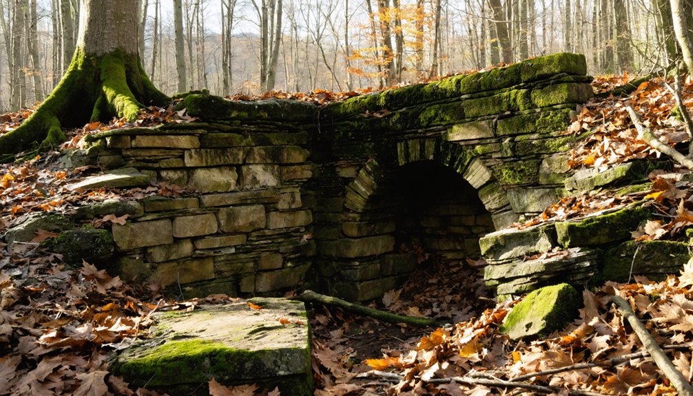
When you walk through what’s left of Fayville today, you’ll find charcoal kilns still standing like stubborn sentinels amid the encroaching forest, their stone walls holding shape long after the industry that built them collapsed.
Shallow cellar holes pock the earth where homes and a mill once stood, their sunken outlines the only evidence that families lived and worked here.
The roads that once connected this thriving settlement have since been swallowed by the wilderness, surviving now only as faint side paths branching off the Long Trail.
Charcoal Kilns Still Standing
Although the forest has spent over a century reclaiming Fayville, it hasn’t swallowed everything. The charcoal kilns still stand as stubborn reminders of the industry that once drove this mountain community.
Understanding charcoal history here means recognizing these structures as the economic backbone of post-Civil War Glastenbury.
Kiln construction required serious craftsmanship — thick stone walls built to contain intense, controlled burns that converted timber into fuel. You can still walk up and touch them today.
Look for these details when you visit:
- Circular stone foundations rising several feet high
- Blackened interior walls stained by decades of burning
- Carefully fitted stonework that has outlasted every wooden structure nearby
Run your hand along the stones. You’re touching the industry that built and ultimately exhausted this entire settlement.
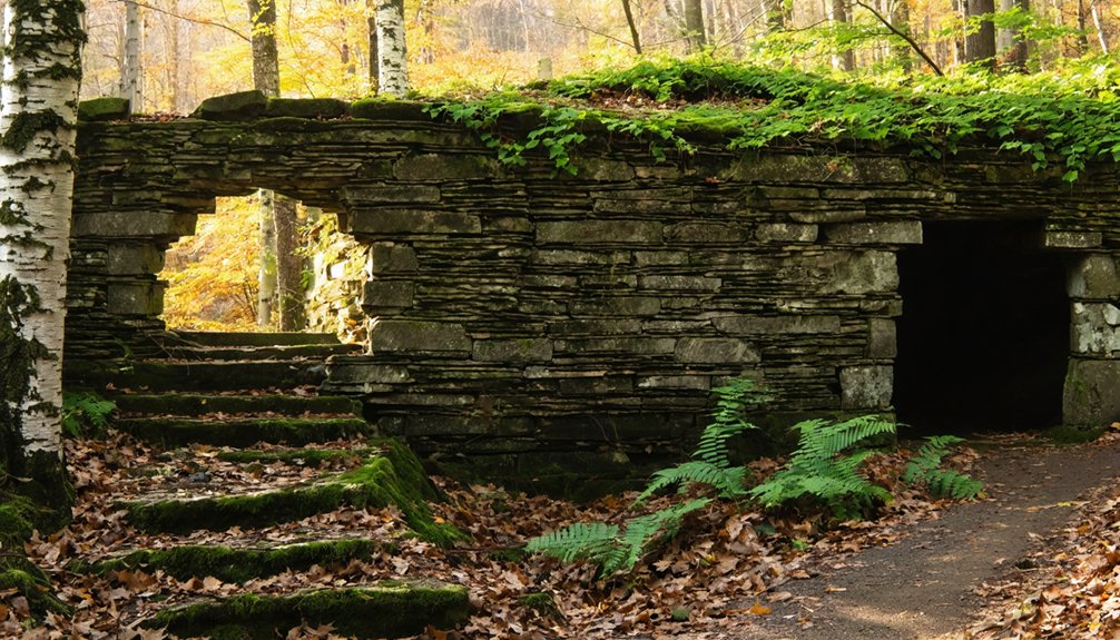
Cellar Holes Mark Homes
Beyond the kilns, the forest floor tells a quieter story — rectangular depressions sunk into the earth where family homes once stood.
These cellar holes are Fayville’s most intimate ruins, each one marking a life that industry once sustained. During cellar exploration, you’ll notice stone-lined walls still holding shape beneath decades of leaf litter and roots.
Their historical significance runs deep. Families who logged, burned charcoal, and built a functioning mountain community left these as their only signatures.
No plaques mark them. No fences protect them. The forest simply reclaimed everything above ground while the foundations remained.
Walk carefully — edges crumble.
But stand at the rim of one, and you’ll feel the weight of a settlement that flourished, faded, and now belongs entirely to the wilderness.
Reclaimed Roads And Trails
The cellar holes don’t stand alone — roads once connected them, threading through Fayville’s hills to link homes, kilns, and mills into a working community.
Now, the forest has quietly swallowed those routes whole. You’ll find reclaimed pathways folding back into root systems, moss, and shadow during your wilderness exploration.
The Long Trail’s side paths trace these old corridors, revealing what time hasn’t fully erased:
- Faint road beds still cut through dense tree lines
- Charcoal kiln ruins mark former industrial hubs along forgotten routes
- Overgrown clearings signal where wagons once rolled freely
Walk slowly here. The land speaks if you listen.
Every sunken trail and vine-covered shoulder tells you that Fayville didn’t vanish — it simply returned to the wilderness it was carved from.
Best Trails for Exploring Glastenbury’s Kilns and Cellar Holes
Wandering through Glastenbury’s overgrown wilderness, you’ll discover that the Long Trail and its side paths offer the most rewarding access to the ghost town’s scattered ruins. Follow these reclaimed roads carefully, and you’ll stumble upon weathered charcoal kilns and moss-covered cellar holes that whisper stories of the town’s industrial past.
For hiking safety, always carry a detailed map, since trail markers can disappear beneath dense undergrowth. Tell someone your plans before heading out, and stick to daylight hours when local wildlife is more predictable and visible.
The kilns clustered near former Fayville reward the most determined explorers, while cellar holes dot the forest floor unexpectedly. Every step deeper into this 36-square-mile wilderness connects you directly to Glastenbury’s fascinating, forgotten history.
Bigfoot, Abenaki Warnings, and Glastenbury Legends
Glastenbury’s legends run far deeper than abandoned kilns and cellar holes. The Abenaki legends warned that this mountain was cursed, a place where man-eating stones and violent winds made survival uncertain. They weren’t wrong to stay away.
The Abenaki didn’t abandon Glastenbury out of superstition — they left because the mountain itself warned them away.
You’ll find centuries of eerie encounters layered into this wilderness:
- Bigfoot sightings dating back to 1879 describe an 8-foot hairy creature roaming these woods.
- Paranormal activity includes strange lights, unidentifiable odors, and sounds nobody can explain.
- Five people vanished between 1945 and 1950, earning the area its “Bennington Triangle” name.
The Abenaki believed the Four Winds converged here, stirring something restless.
Whether you’re skeptical or a true believer, Glastenbury’s reputation demands respect. Walk these trails with awareness — not fear.
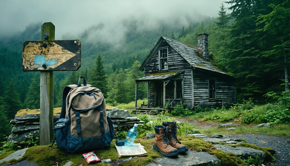
What to Pack for a Day Hike to Glastenbury Mountain
Legends and cursed mountains aside, you’ll want solid preparation before you set foot on Glastenbury’s trails. This wilderness swallows the unprepared whole — and that’s before you factor in the Bennington Triangle’s reputation.
Pack these hiking essentials: a detailed topographic map, compass, headlamp, first aid kit, and enough water for the full elevation gain to 3,747 feet. Dress in layers; mountain weather shifts fast. Wear sturdy boots — cellar holes and reclaimed roads hide beneath undergrowth.
For trail safety, tell someone your exact route and expected return time before you leave. Explore during daylight only; the forest closes in quickly at dusk.
The Long Trail’s side paths reward the prepared hiker with charcoal kilns and ruins — but only if you’re smart enough to find your way back out.
When Is the Best Time to Visit Glastenbury?
You’ll find Glastenbury most welcoming in late spring through early fall, when the trails dry out and the forest canopy bursts with life.
Summer days give you the longest window of daylight to explore the ghost town ruins, charcoal kilns, and cellar holes without racing the sunset.
Whatever season you choose, you’ll want to arrive early—this wilderness doesn’t forgive those who linger past dusk.
Optimal Visiting Seasons
Although Glastenbury welcomes visitors year-round, late spring through early fall offers the most rewarding experience. You’ll find ideal hiking conditions when trails are clear and seasonal wildlife roams freely through the wilderness.
- Late Spring (May–June): Wildflowers carpet the forest floor, streams run full, and the ghost town ruins emerge dramatically from receding snow.
- Summer (July–August): Long daylight hours give you maximum exploration time through Fayville’s cellar holes and charcoal kilns.
- Early Fall (September–October): Vermont’s famous foliage transforms the 36-square-mile wilderness into a stunning backdrop for your ghost town adventure.
Winter visits are possible but challenging—deep snow buries historical remnants and trails become treacherous.
Whatever season you choose, carry a map and tell someone your plans before heading into this remote wilderness.
Daylight Hours Matter
Choosing the right season is only half the battle—the time of day you step into Glastenbury’s wilderness matters just as much. Daylight safety isn’t optional here; it’s your lifeline. Five people vanished in this area between 1945 and 1950, and the dense forest swallows trails faster than you’d expect.
Always arrive early, giving yourself maximum daylight hours to explore the charcoal kilns, cellar holes, and Long Trail paths before shadows take over.
Pack your hiking essentials—a reliable map, flashlight, water, and emergency contacts. Tell someone exactly where you’re going before you leave. This isn’t paranoia; it’s smart freedom.
The wilderness rewards the prepared traveler and punishes carelessness. Glastenbury’s haunting beauty deserves your full, unrushed attention—under the sun, not after it disappears.
Ghost Towns Near Glastenbury for the Same Day Trip
Since you’re already making the trek to Glastenbury’s wilderness, rounding out your day with nearby ghost towns transforms the trip into a richer exploration of Vermont’s forgotten past.
These ghost towns carry their own Vermont folklore, each whispering stories of industry, hardship, and abandonment:
- Fayville – Glastenbury’s original settlement, now reduced to cellar holes and overgrown foundations swallowed by forest.
- Somerset – A neighboring community that quietly emptied after logging and industrial decline stripped away its purpose.
- Glastenbury Village – The mountain’s namesake settlement, where charcoal kilns and Long Trail side paths reveal what once thrived here.
Cluster these stops together strategically. Each site sits within reasonable driving distance, letting you experience Vermont’s haunted history without backtracking across the region unnecessarily.
Frequently Asked Questions
Are Permits Required to Camp Overnight Near Glastenbury Mountain?
Like a wild frontier, Glastenbury’s camping regulations aren’t explicitly documented here. For overnight camping near Glastenbury Mountain, you’ll want to check with Green Mountain National Forest directly, as they manage the wilderness area’s specific permit requirements.
Can I Bring My Dog on the Long Trail to Glastenbury?
You can bring your dog on dog friendly trails to Glastenbury, but prioritize hiking safety — keep them leashed in the wild, untamed wilderness, carry extra water, and watch for rugged terrain on Long Trail paths.
Is There Cell Phone Service Available on Glastenbury Mountain Trails?
Like a ghost town itself, cell coverage vanishes on Glastenbury’s mountain trails. You’ll find yourself gloriously disconnected from the modern world, so carry a map and embrace the wild, untethered freedom awaiting you there.
Are There Any Guided Tours Available for Glastenbury Ghost Town Visits?
No official guided tours exist, but you can independently explore Glastenbury’s ghost town history along Long Trail paths. You’ll discover charcoal kilns and cellar holes through self-guided exploration, embracing the freedom of this hauntingly remote, untamed wilderness.
What Emergency Services Are Accessible Near the Glastenbury Wilderness Area?
Like a lifeline thread through wilderness darkness, you’ll need emergency contacts before entering Glastenbury’s vast 36-square-mile expanse. Prioritize wilderness safety by informing a friend and carrying maps, as services remain extremely remote here.
References
- https://mysterioushillsdotcom.wordpress.com/2021/02/13/snapshots-of-a-ghost-town-fayville-vt-2004/
- https://www.onlyinyourstate.com/experiences/vermont/ghost-town-vt
- https://happyvermont.com/2014/10/23/glastenbury-ghost-town/
- https://www.youtube.com/watch?v=ScW-H7A8yL8
- https://vermontcountry.com/2023/10/26/the-haunting-of-glastenbury-mountain/
- https://myfamilytravels.com/supposedly-boring-vermont-towns-hiding-some-truly-strange-landmarks
- https://www.youtube.com/watch?v=6zrC4j7tGHE
- https://en.wikipedia.org/wiki/Glastenbury


