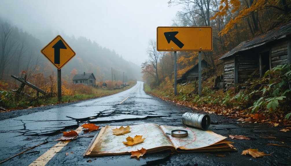
You’ll find Foster ghost town seventy miles east of Pittsburgh via US-22 E, a two-hour drive through Indiana County’s coal country. Navigate to Conemaugh Township using PennDOT maps or searching “Foster ghost town Conemaugh Township,” then access the site via Morianna Road near the Ghost Town Trail. Winter offers ideal viewing of the crumbling coke ovens and scattered foundations through bare trees. The ruins demand careful observation since nature’s reclaimed this 1948 mining closure, though nearby abandoned communities can extend your exploration into a detailed western Pennsylvania coal heritage journey.
Key Takeaways
- Foster Ghost Town is located in Conemaugh Township, Indiana County, accessible via Morianna Road and Leonard Avenue off the Ghost Town Trail.
- Drive from Pittsburgh takes approximately 2 hours via US-22 E, covering 62.2 miles with real-time navigation recommended through Waze.
- The site features coke oven ruins, crumbling mining foundations, and old rail traces with no preserved buildings or interpretive signage.
- Winter visits provide optimal viewing conditions when bare trees reveal scattered stone foundations and architectural details more clearly.
- Budget-friendly Greyhound bus or comfortable Amtrak train options available for travelers preferring alternatives to driving from Pittsburgh.
What Makes Foster a Unique Western Pennsylvania Ghost Town
Foster distinguishes itself among western Pennsylvania’s ghost towns through its complete surrender to the Appalachian wilderness. You won’t find preserved buildings or interpretive signs here—just scattered stone foundations and concrete traces disappearing beneath forest overgrowth. Unlike Eckley’s museum-quality preservation or Scotia’s graffiti-covered remnants, Foster offers raw authenticity. The rustic architectural details that remain—fragmentary walls, old pathways, hints of home sites—demand your careful observation as you explore on foot.
What truly sets Foster apart is its wildlife habitat reclamation. This former coal mining community has transformed completely, with the ecosystem erasing industrial scars. You’ll navigate forests where miners once walked streets, discovering how nature methodically reclaims human ambition. It’s accessible via the Ghost Town Trail network, offering unrestricted exploration through this quiet monument to Pennsylvania’s coal era.
The Rise and Fall of Foster’s Coal Mining Industry
The boom began not in Foster itself, but in the surrounding coal-rich hills of western Pennsylvania, where bituminous deposits had drawn miners since the late 1700s. By 1830, Pittsburgh alone consumed over 400 tons daily, fueling steel mills and westward expansion.
By 1830, Pittsburgh’s insatiable appetite for coal signaled the transformation of Pennsylvania’s hills into America’s industrial powerhouse.
Foster’s mining operations evolved through three critical phases:
- Manual labor era (1760s-1830s): Room-and-pillar methods with horse-drawn wagons
- Industrial expansion (1881-1915): Rochester & Pittsburgh Coal & Iron Company’s dominance until railroad monopolies crumbled
- Modern mechanization (1960s): Longwall mining replaced traditional techniques
Labor relations challenges erupted violently during 1916-1922, when over 1,000 strikes rocked Central Pennsylvania. The fatal riot at Foster mines near Edri in 1922 required National Guard intervention.
Technological advancements couldn’t save the industry’s decline—freedom from coal’s grip came at devastating economic cost.
How to Find Foster in Conemaugh Township
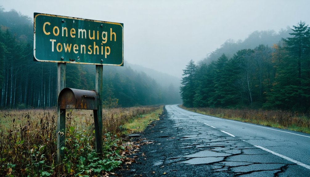
Locating this elusive coal mining settlement requires careful navigation through Pennsylvania’s overlapping place names, as multiple communities share the Foster designation across different counties. You’ll need to specify Conemaugh Township in Indiana County—not Foster Township in Luzerne County, which houses the Eckley mining museum. PennDOT’s Type 5 maps and GIS resources prove invaluable, displaying township borders and historical mining maps that pinpoint Foster’s exact location among western Pennsylvania’s coal regions.
Search specifically for “Foster ghost town Conemaugh Township Indiana County” to filter irrelevant results. The Ghost Town Trail passes through this area, connecting nearby abandoned settlements like Claghorn, Dias, and Dilltown. Roads including Morianna Road and Leonard Avenue provide access points, though dense forest and scattered homes characterize this semi-abandoned landscape where freedom-seekers discover authentic remnants.
Best Route From Pittsburgh to Foster Ghost Town
When planning your expedition from Pittsburgh to Foster’s abandoned coal patch, you’ll cover approximately 62 miles eastward through Indiana County’s rugged terrain—a journey that transforms modern highways into pathways connecting Pennsylvania’s industrial past.
Your navigation options include:
- Direct drive via US-22 E – The cheapest route at 62.2 miles, delivering you to Ghost Town Trail highlights within two hours
- Amtrak train plus taxi – Rated best for comfort, this combination lets you appreciate the landscape before accessing abandoned coal company housing sites
- Greyhound bus hybrid – Budget-conscious travelers can connect through Foster-area stops, though schedules require flexibility
Use Waze for real-time conditions along these historic corridors. Each route ultimately delivers you to Conemaugh Township’s preserved mining remnants, where Foster’s skeletal structures await exploration.
What Remains at the Foster Site Today
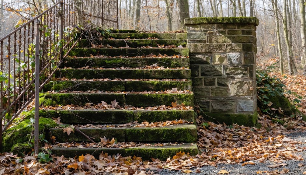
When you arrive at Foster’s site today, you’ll find scattered coke oven ruins standing as skeletal reminders of the town’s industrial past, their brick archways still visible among the encroaching vegetation.
The crumbling foundations of mining infrastructure mark where processing buildings and tipples once dominated the landscape, now reduced to concrete slabs and rusted iron fragments.
You can trace the old rail lines if you know where to look—overgrown but still discernible as they cut through the forest, leading to loading areas that haven’t seen a coal car in decades.
Coke Oven Structural Ruins
You’ll discover these physical remnants:
- Intact brick archways showing original masonry patterns where coal was loaded through top holes
- Crushed stone foundations marking where hundreds of ovens once fired continuously
- Adjacent coke crusher sites still identifiable near oven rows
Winter visits offer optimal viewing through bare trees. Oven conservation challenges intensify as nature reclaims these structures, though they represent vital artifacts among Pennsylvania’s original 38,000 coke ovens.
Mining Infrastructure Foundations
The landscape at Foster bears witness to over a century of extraction through scattered concrete foundations that mark where massive coal breakers once dominated the skyline. You’ll discover mounting brackets still embedded in these weathered footings, silent anchors where motors and conveyor systems once thundered.
These machinery mounting foundations reveal the operational layout of anthracite processing, with structural remnants positioned precisely where engineers calculated load-bearing requirements.
As you explore nearby drift entrances, you’ll find additional concrete work that protected underground mine entry locations from collapse. Road construction and trail development continue exposing previously buried foundations, expanding the visible footprint of Foster’s industrial past.
Each foundation tells you exactly where workers stood, where coal flowed, and how this community extracted wealth from Pennsylvania’s coal seams.
Overgrown Rail Line Traces
Where coal breakers once connected directly to processing facilities, rusted rail traces now disappear beneath tangles of birch saplings and blackberry vines at Foster. You’ll need persistence to locate these hidden railroad alignments, as nature’s reclaimed what industry abandoned decades ago.
What You Can Still Find:
- Embedded rail ties jutting through overgrown vegetation, marking the exact paths where coal cars once rumbled toward Black Lick Creek loading stations
- Junction switches identifiable by their distinctive spacing patterns, revealing where double lines diverged to serve multiple mine operations simultaneously
- Intact rail infrastructure segments showing preserved rails and ties in select clearings, offering tangible connections to Foster’s 1900s coal transport network
You’re exploring remnants most visitors miss—these overgrown corridors tell Foster’s industrial story better than any interpretive sign.
Nearby Abandoned Towns to Add to Your Route

Branching out from Foster opens up a constellation of abandoned coal towns that trace the rise and fall of Pennsylvania’s mining empire. Claghorn sits along the Ghost Town Trail in East Wheatfield Township, where you’ll find abandoned mining equipment rusting among the trees.
Head west to Dilltown in Buffington Township, once a thriving commerce center now reduced to scattered infrastructure remnants and historic cemetery remnants marking forgotten families.
Dias offers sparse ruins in Brush Valley Township’s rural landscape, accessible via short drives through former coal country. For water enthusiasts, Cokeville‘s submerged remains lie beneath Conemaugh River Lake—a flooded Pennsylvania Canal town with relics from dam construction.
If you’re planning an extended route, Eckley in Luzerne County’s Foster Township operates as a preserved mining museum with intact buildings.
Essential Safety Tips for Exploring Mining Ruins
While these forgotten coal towns offer compelling glimpses into Pennsylvania’s industrial past, they’re simultaneously among the most dangerous sites you can encounter. Following proper safety protocol isn’t optional—it’s essential for survival.
Recommended exploration gear and precautions include:
- Stay completely clear of water-filled quarries and pits. These deceptively deep pools contain submerged machinery, electrical hazards, and temperatures cold enough to incapacitate you within minutes. The surrounding walls are too steep and slippery for escape.
- Never enter underground sections or approach vertical shafts. Cave-ins happen without warning, and those hundred-foot drops are often hidden by vegetation. Degraded explosives remain from mining operations, becoming unstable enough to detonate from a footstep.
- Bring offline maps and proper lighting equipment. Cell service is nonexistent in these remote locations.
Building the Perfect Multi-Stop Ghost Town Itinerary

When you’re mapping your ghost town route through Western Pennsylvania’s coal country, you’ll want to anchor your day around Foster in Indiana County’s Conemaugh Township, then connect it to nearby sites within a 30-mile radius.
The Ghost Town Trail naturally links Foster with Claghorn in East Wheatfield Township, while Fillmore and Cokeville lie submerged beneath Conemaugh River Lake just miles away—both accessible via the dam area.
Budget 45 minutes to an hour at each ruin cluster, accounting for the overgrown footpaths and stone foundations you’ll need to navigate through the woods between stops.
Route Planning Essentials
Planning your ghost town road trip demands more than plotting points on a map—it requires understanding how these abandoned settlements connect through landscape, history, and accessible routes. Your thorough planning approach should account for seasonal road conditions, vehicle requirements, and backup options when primary routes become impassable.
Essential route mapping considerations:
- Vehicle capability assessment – The 59-mile gravel road to Kennecott needs high clearance, while Kirwin’s 38-mile approach demands 4WD for steep grades and river crossings.
- Weather-dependent access – Early-season routes to Bodie turn treacherously slippery when rain hits, and Stateline Mine’s dirt roads spawn blinding dust storms.
- Strategic base camps – Position yourself near amenities like Wade Lake Resort or Molas Lake Campground to explore multiple sites without backtracking daily.
Timing Between Ghost Towns
Your mapped route means nothing if you miscalculate the hours between abandoned settlements. Foster to Claghorn requires just 30 minutes within Indiana County, but seasonal variability transforms that estimate—winter snow doubles your drive on unplowed backroads.
Road conditions dictate whether you’ll explore three coal patches or one. Spring floods near Conemaugh add an hour to Cokeville access, while fall foliage crowds delay Rausch Gap arrivals by thirty minutes.
The Westmoreland coal town loop (Foxtown to Salemville) takes twenty minutes in summer but forty when gravel paths turn muddy. Budget Eckley to Centralia at one hour via I-81, yet account for mine fire smoke reducing visibility year-round.
Mountain terrain between Elk County sites demands patience—steep, winding roads add thirty minutes you can’t reclaim.
Must-See Stop Combinations
Since Foster anchors Pennsylvania’s coal region ghost town network, you’ll maximize discoveries by building loops that keep driving under two hours while hitting five to seven sites per day.
Top Three Multi-Stop Combinations:
- Coal Region Loop: Circle from Foster to Claghorn along Ghost Town Trail, then hit Fillmore and Cokeville—both submerged mining towns under Conemaugh River Lake. End at Foxtown for accessible ruins.
- Eckley Museum Cluster: Start at Eckley Miners’ Village for guided tours revealing immigrant miner history, then visit Yellow Dog Village’s National Register structures and Edgerton’s preserved foundations.
- Eastern Ruins Circuit: Combine Eckley with Frick’s Lock nuclear ghost town, Alvira’s WWII bunkers, Byrnesville’s underground fire zone, and Wehrum’s forest-reclaimed remains.
Each route delivers distinct historical narratives while minimizing backtracking.
Frequently Asked Questions
Are There Any Restaurants or Gas Stations Near Foster Ghost Town?
Foster Ghost Town lacks nearby dining options and availability of fuel sources due to its abandoned status. You’ll need to venture to surrounding towns like Drums, where the historic Meating House has served travelers since the 1860s stagecoach era.
Can I Bring My Dog When Exploring Foster’s Ruins?
You can bring your dog to Foster’s ruins on leashed trails, but follow safety guidelines: keep them within six feet, watch for unstable structures and mine shafts, and pack water since these remote Appalachian paths lack services.
Is Cell Phone Reception Available in the Foster Area?
You’ll face cellular coverage limitations throughout Foster’s remote McKean County location. AT&T provides the strongest signal, but expect unreliable connectivity among abandoned structures. Download offline maps beforehand—you’ll need independence from digital networks while exploring these forgotten ruins.
Do I Need Permits to Photograph Foster’s Abandoned Structures?
You’ll need to obtain necessary permissions since Foster’s structures likely sit on private land. Respect private property rights—Pennsylvania has over 300 ghost towns, yet trespassing remains illegal. Always seek landowner consent before photographing abandoned buildings.
What’s the Best Season to Visit Foster Ghost Town?
You’ll find autumn offers ideal weather conditions for exploring Foster’s ruins, with comfortable temperatures and stunning foliage framing crumbling structures. The crisp air and golden light create perfect photography conditions while you’re freely wandering through this forgotten Pennsylvania settlement.


