You’ll find Fruita nestled along Highway 24 in Capitol Reef National Park, where the Fremont River still nourishes 3,000 fruit trees planted by Mormon pioneers in the 1880s. Take exit 149 from I-70 and drive 80 miles through stunning desert landscape to reach this accessible ghost town. The 1896 schoolhouse and Gifford Homestead remain preserved, while spring brings ideal hiking weather and fall delivers U-Pick apple harvesting. Guaranteeing campground reservations six months ahead confirms you’ll experience everything this remarkable settlement offers beyond its weathered facades.
Key Takeaways
- Access Fruita via Highway 24, traveling 80 miles from I-70 exit 149 or 82 miles east from Salina.
- Visit March-June for ideal hiking weather or September-October for apple picking and fall foliage along Scenic Drive.
- Explore the 1896 schoolhouse, Gifford Homestead for fresh pies, and 3,000 fruit trees available for U-Pick harvesting.
- Reserve Fruita Campground six months ahead; it’s located one mile south of the Visitor Center near Fremont River.
- Extend your trip to Capitol Gorge’s Pioneer Register, Fremont petroglyphs, and the 37-mile Blue Dugway backcountry route.
The Mormon Pioneer Settlement That Became a Ghost Town
In 1880, when Nels Johnson and his band of Mormon pioneers first surveyed the junction where Sulphur Creek meets the Fremont River, they found what most would consider an impossible place to build a life. The Capitol Reef region had remained uncharted until 1872, its rugged terrain and Native American history keeping settlers at bay.
Yet these pioneers saw opportunity where others saw only obstacles. They named their settlement “Junction,” later changing it to “Fruita” in 1902 as orchards transformed the desert into Wayne County’s garden. The Fremont River provided reliable irrigation, and through sheer determination, ten families carved out an existence that would earn cultural significance as a symbol of frontier self-reliance—before the National Park Service purchased the town in 1955, ending seventy-five years of stubborn survival. The community flourished under the leadership of Amasa Pierce, who served as the presiding Church elder. Despite never exceeding 300 acres, the settlement became significant due to its relatively long growing season and abundant water supply.
Getting to Fruita in Capitol Reef National Park
Reaching Fruita requires commitment—this isn’t a destination you’ll stumble upon while running errands. You’ll navigate Utah’s red rock country via Highway 24, where directional highway signage guides you through 80 miles of stunning desert landscape from I-70’s exit 149.
From I-15, you’ll wind through Scipio and Salina before Highway 24 carries you 82 miles eastward. There’s no public transportation access here—you’re on your own wheels, which suits this adventure perfectly.
The Visitor Center sits just off Highway 24 at 5,436 feet elevation, where Fremont River meets Sulphur Creek. You’ll find yourself 7 miles from the western entrance, surrounded by the dramatic Waterpocket Fold. Fruita Campground lies one mile south of the visitor center, offering an oasis-like setting within the desert. This isolation defines Fruita’s ghost-town character—remote, authentic, and worth every mile. While sharing a name with Colorado’s Fruita, this Utah settlement sits 17 miles from Utah’s eastern neighbor across the state line.
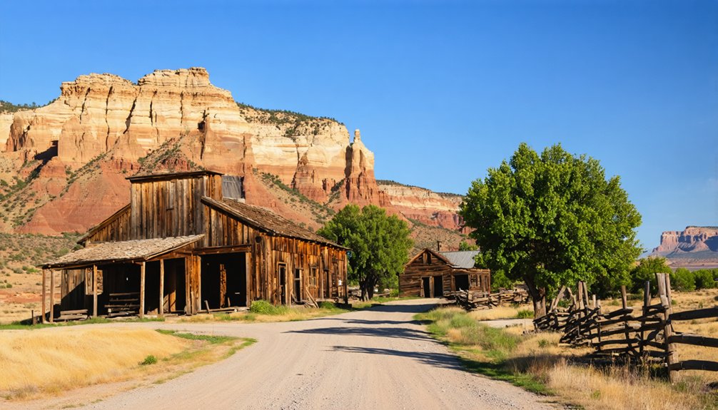
Historic Buildings and Orchards to Explore
Stepping back from the visitor center, you’ll discover Fruita’s authentic pioneer legacy scattered across this narrow canyon floor—weathered wooden structures that once anchored a self-reliant farming community now stand preserved among the same orchards their builders planted over a century ago.
The 1896 historic school house preservation lets you peer through windows at movable desks that transformed one room into classroom, dance hall, and church. Down the road, gifford homestead experiences deliver fresh-baked pies and cinnamon rolls from March through October—the same kitchen where three families lived from 1908 to 1969.
Wander through 3,000 fruit trees bearing apples, cherries, and peaches available for U-Pick harvesting. The orchards were planted in the late 1800s by pioneer settlers who established the Fruita Historic District. The blacksmith shop displays pioneer tools, while Fremont petroglyphs line cliffsides 1.5 miles east, carved between 300-1300 CE. The Merin Smith Implement Shed showcases original pioneer equipment that reveals how early settlers worked this rugged terrain.
Best Times to Visit and What to Bring
Timing your Fruita visit transforms a simple ghost town stop into an unforgettable sensory experience—I’ve watched morning light gild 1,100-year-old Fremont petroglyphs in crisp October air, tasted sun-warmed apples pulled straight from century-old branches in September, and savored complete solitude on snow-dusted trails during February afternoons when the park sees just a fraction of its summer crowds.
Seasonal temperature variations dramatically shape your experience. Spring (March-June) delivers ideal hiking conditions with 60s-70s°F temperatures and wildflower-studded trails. Fall (September-October) offers harvest-season apple picking and peak foliage along Capitol Reef Scenic Drive. Summer demands early-morning starts to beat heat and crowds. Cooler weather in the fall makes it easier to hike for longer periods without exhaustion.
Pack layers regardless of season, bring bags for orchard bounty, and secure Fruita Campground reservations ($25/night) six months ahead. To maximize solitude, plan your visit early in the morning or after sunset for stargazing opportunities. Check road conditions at 435-425-3791 before departing.
Nearby Attractions and Extended Road Trip Options
Beyond Fruita’s orchards and pioneer remnants, Capitol Reef National Park unfolds into a 100-mile-long wrinkle in the earth’s crust—the Waterpocket Fold—where you’ll discover hidden ghost settlements that most visitors never reach.
Beyond the crowded viewpoints lies Capitol Reef’s true treasure: a century-old wrinkle hiding ghost towns in 100 miles of folded stone.
Drive Capitol Gorge’s narrow passage to find the Pioneer Register carved into canyon walls, then continue to Aldridge’s ruins 11.1 miles east, where flooding drove out a dozen families in 1900.
For petroglyphs exploration, two boardwalks along Route 24 reveal Fremont Culture‘s 1,000-year presence—bring binoculars for elevated anthropomorphs. The shorter boardwalk offers a broader view of the petroglyphs, while the longer boardwalk provides a bird’s-eye perspective.
Twenty miles east, Caineville stands where the Behunin family established roots in late 1882, though major floods in 1896 and 1909 drove most settlers away by 1900.
The primitive Blue Dugway offers adventurous souls a 37-mile backcountry escape through geological features that tested pioneers.
Connect these sites into multi-day loops, camping between locations, answering only to desert silence and your own timeline.
Frequently Asked Questions
Are There Any Entrance Fees Required to Visit Fruita?
You’ll pay no entrance fee to explore Fruita itself, though accessing the Scenic Drive beyond requires standard park admission. The area’s accessibility for visitors and seasonal hours of operation make it perfect for your spontaneous ghost town adventure.
Can Visitors Pick Fruit From the Historic Orchards in Fruita?
Like Johnny Appleseed’s legacy, you’re free to pick fruit once harvest begins! Seasonal fruit availability spans cherries through apples, June-October. Thanks to dedicated orchard maintenance requirements, you’ll discover 1,900 heritage trees awaiting your harvest basket.
Is Camping Available Near Fruita Ghost Town?
Yes, you’ll find excellent campsite availability at Fruita Campground’s 65 reservable sites near the ghost town. This green oasis offers recreational activities like exploring historic orchards and hiking red rock trails, perfect for your freedom-seeking adventure.
Were There Any Notable Conflicts Between Fruita Residents and Native Americans?
No notable conflicts occurred at Fruita itself, though you’re walking land shaped by earlier tensions over land rights and displacement of local tribes. By 1880’s establishment, Utes had already been forcibly relocated to distant reservations decades prior.
What Happened to Fruita’s Original Residents After 1955?
After 1955’s community relocation, you’d find Fruita’s families scattered across Utah, like Cora Oyler Smith who settled in Richfield. They left behind farming challenges when the National Park Service purchased their homes, ending their pioneering lifestyle forever.
References
- https://kool1079.com/ghost-town-fruita-utah/
- https://www.thechurchnews.com/2017/7/31/23212480/fruita-a-tasty-testament-to-mormon-grit-industry/
- https://www.legendsofamerica.com/ut-fruita/
- https://gofruita.com/the-historical-figures-of-fruita/
- https://kids.kiddle.co/Fruita
- https://www.nps.gov/care/learn/historyculture/fruita.htm
- https://capitolreefcountry.com/ghost-towns/
- https://npshistory.com/publications/care/clr.pdf
- https://www.visitutah.com/places-to-go/parks-outdoors/capitol-reef/must-see-capitol-reef/gifford-homestead
- https://en.wikipedia.org/wiki/Fruita


