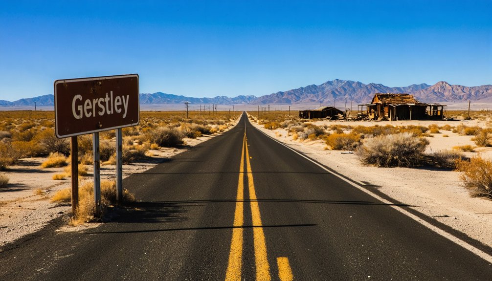
You’ll find Gerstley’s skeletal remains 180 miles northeast of Los Angeles in the Resting Spring Range, accessible via Highway 127 through Death Valley Junction before heading east on rugged dirt roads requiring high-clearance vehicles. Plan your visit during spring or fall to avoid extreme temperatures, and combine the site with nearby Shoshone’s mining exhibits and Death Valley’s borax heritage sites for an extensive desert expedition. The crumbling concrete foundations and scattered antique equipment reward those who venture beyond crowded park entrances to experience authentic frontier history.
Key Takeaways
- Gerstley is located 180 miles northeast of Los Angeles in the Resting Spring Range near the Nevada border.
- Access requires a high-clearance vehicle via Highway 127 north through Death Valley Junction, then east on dirt roads.
- Visit during spring or fall to avoid extreme summer heat and winter flash flood risks.
- Explore scattered concrete foundations, crumbling walls, and antique mining equipment marking the former borax mining community.
- Combine with nearby Shoshone mining exhibits, Furnace Creek, and Boron for a comprehensive Death Valley mining heritage trip.
The History of Gerstley Mine: From Discovery to Abandonment
While prospecting the harsh terrain of California’s Resting Spring Range in 1922, Johnny Sheridan stumbled upon deposits that would briefly transform this remote corner of Inyo County. Living in a cave alongside local fauna, Sheridan embodied the prospector’s lifestyle that defined Death Valley’s mineral discoveries.
His find—primarily ulexite and colemanite—caught Pacific Coast Borax Company‘s attention, who claimed and named the site Gerstley around 1920.
Getting to Gerstley: Location and Route Details
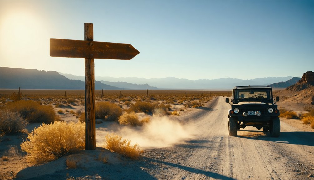
Tucked away in California’s Resting Spring Range near the Nevada border, Gerstley sits approximately 180 miles northeast of Los Angeles and roughly 300 miles southeast of San Francisco. You’ll reach this abandoned mining settlement by taking Highway 127 north through Death Valley Junction, then heading east on dirt roads that wind through untamed desert terrain.
The route demands high-clearance vehicles and careful navigation, as infrastructure development ceased when miners departed decades ago. Spring and fall offer ideal visiting conditions, avoiding summer’s punishing heat and winter’s occasional flash floods.
While traversing these remote paths, you’ll encounter local wildlife habitats supporting bighorn sheep, kit foxes, and desert tortoises. GPS coordinates prove essential since cellular service disappears miles before arrival, making proper preparation non-negotiable for this backcountry adventure.
What Remains: Exploring the Ghost Town Ruins
When you arrive at Gerstley’s coordinates, you’ll find the desert has reclaimed nearly everything—the 16 x 36-foot boarding house is gone, its materials scavenged long ago, and the mine cabins have been relocated or reduced to scattered debris.
The most tangible evidence of human presence appears in subtle ground disturbances: foundation outlines barely visible beneath creosote bushes, and occasional metal fragments half-buried in decomposed granite. Railroad traces, if they existed here, have vanished beneath decades of wind-blown sand, leaving you to piece together this ghost town’s story from absence rather than abundance.
Skeletal Structures and Foundations
Standing amid the scattered ruins of Gerstley, you’ll find skeletal concrete foundations and crumbling walls that mark where a thriving borax mining community once hummed with industrial activity. These remnants reveal natural weathering patterns where desert elements have slowly reclaimed human construction, blending structural edges with surrounding landscape rocks.
Construction material comparisons show varying deterioration rates—concrete bases outlast wooden frames, while exposed metal components display layers of rust accumulation. The original settlement layout remains visible through foundation placements, revealing where housing, administrative buildings, and community centers once served hundreds of workers. Roofless structures stand as neglected monuments, their spatial distribution illustrating the town’s organizational planning.
Scattered iron mining equipment and antique relics positioned outside these skeletal remains preserve Gerstley’s industrial heritage.
Railroad Traces and Artifacts
Beyond the crumbling foundations, Gerstley’s connection to the ambitious Tonopah & Tidewater Railroad becomes evident through subtle traces etched into the desert floor. You’ll discover faint remnant railroad grades marking where the 3-mile narrow-gauge spur once snaked toward the T&T mainline. These rail infrastructure relics speak to the symbiotic relationship between borax mining and desert railroading that defined this region from 1907 to 1940.
The main T&T roadbed remains traceable across 168 miles of Mojave wilderness, its grades visible alongside modern highways. Though dismantled for WWII scrap metal between 1942-1943, the right-of-way’s remoteness preserved its ghostly imprint. You’re free to explore these abandoned routes threading past Death Valley Junction, Tecopa, and Shoshone—tangible evidence of an era when steam and determination conquered impossible terrain.
Ulexite Mining Operations and Their Legacy
When Pacific Coast Borax Company transformed Johnny Sheridan’s 1922 discovery into California’s first solid mineral lease, they sparked an operation that would endure—intermittently—for nearly eight decades.
You’ll find Gerstley’s story echoes the boom-and-bust rhythm that defined Death Valley’s mining era, where initial prosperity gave way to sporadic production cycles of 500-2,000 tons yearly after 1945. The mine’s ulexite and colemanite fed specialized markets from ceramic glazes to nuclear shielding, leaving behind reserves exceeding 1.25 million tons when operations finally ceased in the late 1990s.
Pacific Coast Borax Development
The story of Pacific Coast Borax Company begins with Francis Marion Smith, the “Borax King,” who consolidated scattered mining operations across the Nevada and California deserts into a single empire. His Pacific Coast Borax expansion transformed raw desert minerals into industrial revolution fuel, with Christian B. Zabriskie guiding operations from 1885 through 1933.
Pacific Coast Borax Development Milestones:
- Harmony Borax Works produced 3 tons daily with 35-40 workers from 1883-1888
- Ryan operations housed 100-150 miners, connected by Death Valley Railroad
- Searles Lake processing established Trona company town with dedicated railway
- Boron compound development revolutionized detergents, fiberglass, and fire retardants
You’ll discover how prices plummeted from $4,000 to $38.50 per ton as new deposits opened the frontier to industrial prosperity.
Economic Boom and Bust
During the Roaring Twenties, Johnny Sheridan’s 1922 discovery near Shoshone sparked a mineral rush that would define this remote corner of the Mojave for nearly eight decades.
You’ll find that Gerstley’s economic isolation worked both for and against it—the baby gauge railroad conquered distance but couldn’t overcome resource competition from larger deposits. Production peaked early, with 1922-1927 seeing consistent ore shipments via that ingenious 3-mile rail line to the Tonopah & Tidewater connection.
Then came the bust: October 1927 brought closure as minerals depleted. The mine limped forward sporadically until 1999, producing 500-2,000 tons yearly for specialized applications like nuclear shielding and fire retardants. Today, over 1,250,000 tons remain untouched—a ghost deposit beneath ghost town ruins.
Combining Gerstley With Nearby Death Valley Attractions
Just four miles separate Gerstley’s weathered remnants from Shoshone, making this ghost town an effortless addition to any Death Valley expedition. You’ll discover mining relics that tell ulexite extraction stories while exploring landscapes where ecological impact remains visible decades after 1927’s closure.
Strategic Route Planning:
- Morning Start – Examine Gerstley’s scattered equipment and foundations in cool desert hours
- Shoshone Gateway – Refuel and view mining exhibits documenting borax operations
- Furnace Creek Circuit – Drive north to historic inn and Harmony Borax Works sites
- Boron Connection – Track relocated machinery to active facilities
This southern approach lets you escape crowded park entrances while experiencing authentic desert mining heritage. You’ll traverse Mojave landscapes where prospectors once hauled fortunes, connecting abandoned camps with Death Valley’s legendary borax legacy through unrestricted backcountry exploration.
Multi-Day Ghost Town Itinerary: Bodie, Cerro Gordo, and Beyond
While Death Valley‘s scattered camps offer glimpses into desert mining, California’s eastern Sierra corridor delivers concentrated ghost town grandeur across elevations ranging from alpine meadows to alkali flats. You’ll navigate from Bodie’s 8,500-foot perch—where 110 weathered structures stand in arrested decay—down through sagebrush country to Cerro Gordo’s mountain stronghold.
As you continue your journey, exploring north muroc ghost town reveals even more stories of California’s rich history. Abandoned buildings and remnants of its past stand as silent witnesses to the lives once lived in this remote area. Each step through the dusty streets invites you to imagine the dreams and challenges faced by those who called this ghost town home.
Plan accordingly for accessibility considerations: Bodie’s graded road becomes impassable during winter storms, while Cerro Gordo demands high-clearance vehicles year-round on its eight-mile ascent from Keeler. Off season closures hit both sites November through April, though Bodie’s 200,000 annual visitors concentrate summer months into shoulder-to-shoulder exploration.
Budget three days minimum: one for Bodie’s expansive streets, another tackling Cerro Gordo’s steep switchbacks, with Gerstley’s ruins completing your authentic mining heritage circuit through America’s wildest terrain.
Essential Preparation for Your Desert Ghost Town Adventure
Before you point your vehicle toward Gerstley’s crumbling foundations, understand that this isn’t a casual Sunday drive—it’s an expedition into one of California’s most unforgiving landscapes. Preparation separates memorable adventures from dangerous ordeals in this remote Mojave Desert territory.
Essential Desert Survival Checklist:
- Water supremacy: Pack one gallon per person daily, plus emergency reserves
- Vehicle readiness: High-clearance 4WD with spare tire, tools, full fuel tank from Shoshone
- Communication backup: Satellite device—cell service doesn’t exist here
- Emergency provisions: First aid, flares, layered clothing for extreme temperature swings
The payoff? Unmatched wildlife observation in pristine desert silence and stargazing opportunities beneath skies unpolluted by civilization’s glow. Inform someone of your itinerary, travel with a partner, and respect BLM regulations. This freedom demands responsibility.
Preservation Ethics and Visitor Guidelines
Physical preparation gets you to Gerstley, but understanding your ethical responsibility safeguards these fragile remnants survive for future visitors. At coordinates 36°00′43″N 116°16′28″W, this classified site demands respect beyond typical tourism.
Ethical restoration guidelines emphasize authenticity—historical photographs and period-correct materials preserve mining heritage without modern interference. You’re exploring unprotected spaces where desert winds and vandalism already accelerate deterioration.
Visitor impact management starts with you: photograph structures without touching weakened walls, pack out everything you bring, resist collecting “souvenirs” that erase context for others. Unlike landmark-designated sites with funding and plaques, Gerstley relies on conscientious exploration. Your footsteps either contribute to preservation or hasten collapse.
Freedom to roam these spaces carries weight—leave them undisturbed so tomorrow’s adventurers discover the same authentic remnants you’re experiencing today.
Frequently Asked Questions
Are There Any Guided Tours Available to Gerstley Ghost Town?
No guided tours exist for Gerstley Ghost Town—you’ll find only self-guided tours available. Unlike nearby Calico or Bodie’s private tour offerings, Gerstley remains beautifully untamed, letting you explore its haunting ruins independently at your own adventurous pace.
What Cell Phone Coverage Can I Expect Near Gerstley?
You’ll find limited cellular service in Gerstley’s rugged terrain—no telegraph wires here, just area connectivity issues. Pack offline maps and embrace disconnecting. Verizon and AT&T offer your best shot at occasional signal in California’s remote backcountry.
Can I Camp Overnight at or Near the Gerstley Site?
You can’t camp directly at Gerstley, but nearby camping options include Calico Ghost Town’s developed sites or BLM dispersed areas. The site’s accessibility makes day trips practical, though remote wilderness camping requires permits and careful planning.
What Wildlife Might I Encounter While Visiting Gerstley?
You’ll encounter diverse wildlife including over 50 bird species soaring overhead and numerous wildflower varieties dotting the landscape. Coyotes, bobcats, and gray foxes roam freely through California’s grasslands, while red-tailed hawks patrol open skies above Gerstley’s historic ruins.
Are There Any Fees Required to Visit Gerstley Ghost Town?
Yes, you’ll pay entry fees to explore Gerstley Ghost Town. Adults cost $8, youth (4-15) $5, and children under three enter free. Seasonal accessibility may affect visit times, so check ahead before planning your adventure.


