To plan your ghost town road trip to Greenback, Oregon, plot coordinates 42°39′9″N, 123°18′43″W into your GPS and aim for late spring or early fall when trails are clear. You’ll explore mine tunnel remnants, crumbling foundations, and overgrown stagecoach routes near the California border. Pair it with nearby ghost towns like Waldo, Golden, and Kerby for a full loop through southern Oregon’s forgotten gold country. There’s far more to uncover ahead.
Key Takeaways
- Greenback sits in Josephine County, southern Oregon, three miles north of the California border, with GPS coordinates 42°39′9″N, 123°18′43″W.
- Visit between May and October, when snow has cleared and cooler September temperatures make trail exploration comfortable.
- Use the nearby town of Waldo as a southern landmark when navigating to Greenback’s remote location.
- Remnants include mine tunnel outlines, 1902 foundation traces, and overgrown stagecoach routes along the historic New Leland corridor.
- Extend your trip by visiting nearby ghost towns: Golden, Waldo, Kerby, Placer, and Granite, each offering unique historical character.
Where Greenback, Oregon Sits on the Map
Tucked into the rugged folds of Josephine County in southern Oregon, Greenback sits at coordinates 42°39′9″N, 123°18′43″W — close enough to the California border that you’re practically straddling two states.
You’ll find it just three miles north of that boundary, hugging terrain that once roared with gold fever. The nearby town of Waldo serves as your closest landmark, and the old stagecoach route from New Leland to the Greenback Mine gives you a genuine pioneer pathway to follow.
Three miles from California, where gold fever once raged, Waldo stands sentinel over pioneer trails still waiting to be walked.
As you navigate this remote corridor, you’re moving through a landscape still scarred by historical landmarks and scattered remnants of mining equipment that tell the story better than any museum could.
It’s raw, untamed country — exactly the kind that rewards the boldly curious traveler.
The Gold Rush Roots Behind Greenback’s Rise
When gold fever swept through southern Oregon in the 1850s, it left a permanent mark on the land around what would eventually become Greenback.
You’re walking into a mining legacy built on ambition, sweat, and quartz.
Three key moments shaped this place:
- 1850s placer claims kicked off the regional gold rush, drawing free-spirited prospectors hungry for fortune.
- 1897 founding of the Greenback Mine by Len Browning and Edward Hanum established Oregon’s richest quartz mine by tunnel footage.
- 1902 town establishment by banker William Brevoot transformed a raw mining camp into a functioning supply hub.
The ghost stories here aren’t just legend — they’re embedded in every abandoned shaft and overgrown trail you’ll discover when you explore this forgotten corner of Josephine County.
How the Greenback Mine Became Oregon’s Richest Quartz Operation
When you trace Greenback’s legend back to its source, you’ll find two men — Len Browning and Edward Hanum — driving pickaxes into Oregon hillside in 1897, chasing a quartz vein that would rewrite the region’s mining history.
What they uncovered wasn’t just gold; it was a tunnel system so extensive that it earned the Greenback Mine the title of Oregon’s richest quartz operation, measured by sheer feet of tunnels bored through the earth.
You’re standing on ground where ambition carved itself into rock, foot by relentless foot.
Mine’s Record-Breaking Tunnels
Although gold fever swept through countless Oregon valleys in the 1850s, the Greenback Mine carved out a distinction that set it apart from every other quartz operation in the state: more tunnel footage than any rival ever matched.
When Len Browning and Edward Hanum established the mine in 1897, they pushed tunnel innovations and bold mining techniques deep into Josephine County’s rugged terrain.
Here’s what made their achievement legendary:
- Record footage — They drilled more tunnel feet than any Oregon quartz competitor
- Strategic excavation — Precise mining techniques maximized gold extraction efficiency
- Sustained output — Operations ran profitably enough to attract banker William Brevoot’s 1902 buyout
You’re standing on ground where ordinary men chased extraordinary wealth — and actually found it.
Browning And Hanum’s Discovery
In 1897, Len Browning and Edward Hanum drove their picks into Josephine County’s mineral-rich earth and pulled out something remarkable — a quartz operation that would outpace every rival mine in Oregon by sheer tunnel footage alone.
Their instincts were sharp, their ambitions sharper. You’re walking ground where two determined prospectors carved Oregon’s richest quartz mine from raw wilderness, armed with little more than grit and geological intuition.
Browning’s Legacy echoes through every tunnel foot recorded — a hallmark of bold, independent thinking that defines frontier discovery.
Hanum’s Impact proved equally decisive, transforming a raw claim into a structured operation worth selling. By 1902, banker William Brevoot recognized their achievement’s value, purchasing the mine and building an entire town around what these two visionaries had started.
Why Ghost Town Hunters Seek Out Greenback, Oregon
If you’re drawn to places where gold rush ambition collided with hard reality, Greenback’s remote position in Josephine County pulls you in with its raw, unpolished history tied to Oregon’s richest quartz mine.
You’ll find the isolation itself is part of the appeal — tucked near the California border, far from manicured tourist trails, this class B ghost town rewards explorers who embrace rugged backroads.
Better yet, you can extend your journey through a cluster of nearby abandoned towns like Waldo, Golden, and Kerby, turning a single destination into a full expedition through Oregon’s forgotten mining frontier.
Rich Gold Mining History
What draws ghost town hunters to Greenback, Oregon, isn’t just the remote stillness of Josephine County’s rugged terrain—it’s the layered gold rush story buried beneath it.
Len Browning and Edward Hanum established the Greenback Mine in 1897, making it Oregon’s richest quartz mine by tunnel footage through relentless gold mining techniques.
Three ghost town legends fuel every visit:
- The Richest Tunnel – More feet mined here than anywhere else in Oregon’s quartz history
- The Banker’s Town – William Brevoot purchased the mine in 1902 and built an entire community around it
- The Vanishing Act – Just six years after the post office opened, Greenback went silent
You’re not just exploring ruins—you’re tracing ambition’s blueprint.
Remote Ghost Town Appeal
Greenback, Oregon sits three miles from the California border in Josephine County’s rugged interior, and that near-invisible placement on the map is exactly what pulls ghost town hunters deeper into its story.
Its remote town allure isn’t manufactured — it’s earned through decades of silence following the 1908 post office closure. You won’t find crowds here. You’ll find the raw edges of frontier ambition, where William Brevoot’s banker dreams and Len Browning’s 1897 tunnel cuts dissolved into Oregon’s wilderness.
Ghost town nostalgia hits differently when you’ve navigated old stagecoach routes just to stand where a mining camp once breathed.
Greenback rewards the traveler who craves discovery over convenience, offering unfiltered access to a landscape that history quietly swallowed whole.
Nearby Abandoned Towns
Josephine County packs several ghost towns within striking distance of Greenback, turning a single-site visit into a full expedition through Oregon’s mining past.
You’ll find abandoned structures and ghost town legends scattered across the region, each site rewarding curious explorers willing to push deeper into the backcountry.
Three towns deserve your attention:
- Golden – A rare Oregon Heritage Site featuring preserved churches and no saloons, frozen in frontier character since the 1840s.
- Waldo – Settled in 1852 as Sailor’s Diggings, sitting just three miles from the California border with deep placer mining roots.
- Kerby – A gold camp boasting 500 residents at its peak, still holding historic buildings worth photographing.
String these stops together and you’ve built a serious road trip through Oregon’s vanished frontier.
Why Greenback Was Abandoned by 1908
By 1908, Greenback had already run its course—the post office shuttered, the miners moved on, and the town folded back into the Oregon wilderness as quietly as it had risen.
The economic factors were straightforward: once the Greenback Mine’s richest veins played out, the money dried up fast. Advances in mining technology couldn’t offset the diminishing returns from exhausted quartz deposits.
Without steady gold production, the supply trade supporting nearby camps collapsed too. Len Browning and Edward Hanum’s original 1897 operation had fueled real momentum, but even banker William Brevoot’s investment couldn’t sustain what the earth no longer offered.
You’re now walking into a place that refused to linger—when the gold was gone, Greenback didn’t wait around.
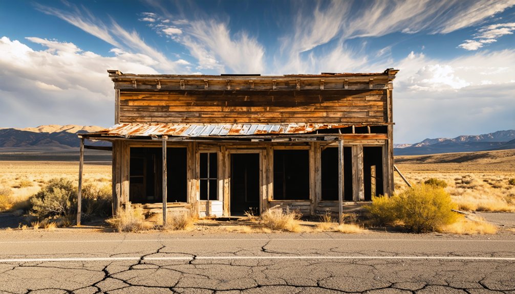
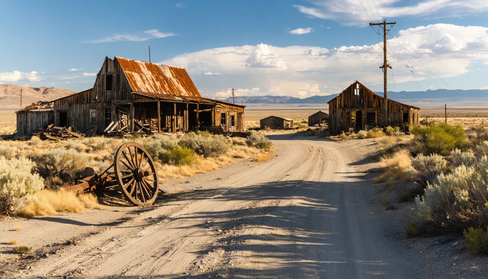
What You Can Still See at the Greenback Town Site
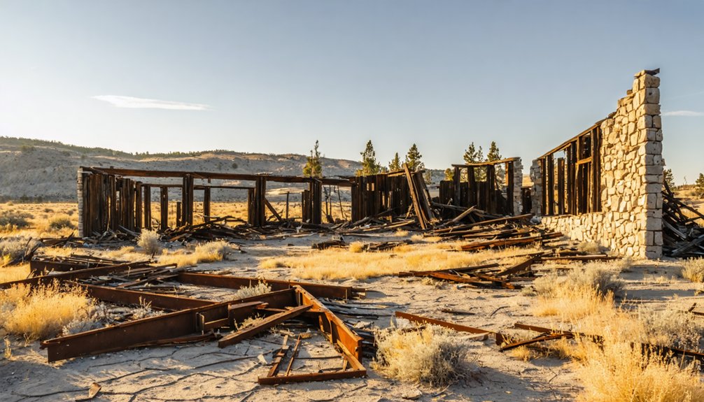
What remains at the Greenback town site won’t hand you a museum experience—you’re piecing together a ghost town from scattered physical evidence tied to an 1897 gold operation that peaked fast and quit faster.
Bring your camera, because ghost town photography rewards sharp eyes here.
Look for:
- Mine tunnel remnants near the Greenback Mine corridor, where quartz-bearing rock still marks the richest tunnel footage in Oregon history.
- Foundation outlines from structures William Brevoot established after purchasing the operation in 1902.
- Overgrown stagecoach traces along the New Leland route that once connected this camp to the outside world.
Historical preservation efforts remain minimal, so document everything carefully.
What you find today may not survive another decade of southern Oregon winters.
The Best Time of Year to Visit Greenback
Late spring and early fall give you the clearest shot at Greenback—snow clears from the Josephine County highlands by May, and September cools the trails before winter closes the old stagecoach routes again.
The best visiting season runs May through October, when the roads linking New Leland to the old mine sites stay passable and daylight stretches long enough for serious exploration. Summer heat peaks in July and August, so pack water and start early.
Fall earns its edge—golden light hits the remnants differently, and regional seasonal events in nearby Kerby and the Applegate Valley give your road trip extra momentum.
Avoid January through March entirely; muddy access roads will strand you miles from anything worth seeing.
How to Reach Greenback Through Josephine County
Reaching Greenback means threading through Josephine County‘s layered backcountry, where modern highways eventually give way to the old stagecoach corridors that once connected New Leland to the mine sites.
Your Greenback access route demands preparation and a spirit for raw terrain.
Follow these navigation essentials for Josephine County travel:
- Plot coordinates 42°39′9″N 123°18′43″W into your GPS before losing signal on backcountry roads.
- Use Waldo as your southern landmark, sitting just three miles from the California border and orienting your approach.
- Study historical stagecoach routes connecting New Leland to the Greenback Mine, since those corridors still shape today’s dirt road networks.
Keep your tank full, your maps downloaded offline, and your sense of direction sharp.
Ghost Towns Near Greenback Worth Adding to Your Route
Once you’ve soaked in Greenback’s quiet ruins, Josephine County’s broader ghost town circuit rewards the curious traveler willing to push a few miles further.
Golden, a class C-F site and Oregon Heritage landmark since 2011, sits nearby with its historic churches and conspicuously saloon-free past, while Waldo — settled in 1852 as Sailor’s Diggings — hugs the California border just three miles south.
You’ll also want to pencil in Kerby, a 1850s gold camp that once swelled to 500 residents and still holds historic buildings worth the detour.
Nearby Ghost Towns Overview
Greenback doesn’t have to be your only stop — Josephine County packs in enough ghost towns to fill a serious road trip itinerary.
Each site offers something distinct, rewarding travelers who value ghost town preservation and raw mining heritage.
Here are three towns worth plotting on your map:
- Golden — A rare Oregon Heritage Site since 2011, featuring intact churches and no saloons in its history, just quiet pioneer authenticity.
- Waldo — Settled in 1852 as Sailor’s Diggings, sitting just three miles from the California border with deep placer mining roots.
- Kerby — A 1850s gold camp that once housed 500 residents, still holding historic structures worth exploring.
String these together and you’ve built a genuinely unforgettable route through Oregon’s forgotten frontier.
Planning Your Extended Route
If you’re ready to push deeper into southern Oregon’s mining past, two more ghost towns deserve a spot on your extended route: Placer and Granite.
Placer served as a hardworking early 1900s supply point, fueling nearby mines when the hills still promised fortune. Add it to your route highlights for a raw, unfiltered glimpse of frontier logistics.
Granite tells a bolder story. Gold discovered there in 1862 sparked a boom of saloons, stores, and relentless ambition.
Today, only a dozen residents remain, making it one of Oregon’s most atmospheric scenic stops. Walking its quiet streets, you’ll feel the weight of everything that was built, lost, and left behind.
These two towns transform a simple day trip into something genuinely unforgettable.
A Ghost Town Road Trip Loop Anchored at Greenback
Tucked into the rugged hill country of Josephine County, the ghost town of Greenback makes a natural anchor for a southern Oregon mining loop that hits several abandoned settlements in a single drive.
Its historical significance as home to Oregon’s richest quartz mine by tunnel footage gives you real context before you roll deeper into the district.
Build your loop around these three stops:
- Waldo – Settled in 1852 as Sailor’s Diggings, sitting just three miles from the California border.
- Golden – A designated Oregon Heritage Site offering remarkable ghost town photography opportunities among preserved church structures.
- Kerby – A 1850s gold camp with surviving historic buildings and a peak population of 500.
Each stop layers the story tighter.
Frequently Asked Questions
Is a Permit Required to Visit the Greenback Ghost Town Site?
Like a door left open by history itself, you don’t need a permit to explore Greenback’s ghost town history. Follow visiting tips: respect the land, roam freely, and embrace your adventurous spirit!
Are There Any Guided Tours Available for Greenback and Nearby Ghost Towns?
No formal guided tours exist, but you can pursue self-guided exploration through Josephine County’s rich ghost town history. Hire a local historian, grab detailed maps, and you’ll uncover Greenback’s forgotten secrets on your own thrilling terms.
Can You Camp Overnight Near the Greenback Ghost Town Area?
You’ll find camping options near Greenback’s haunted hills in Josephine County’s rugged wilderness. Pitch your tent, breathe free mountain air, and explore nearby attractions like Golden and Waldo’s ghost towns at dawn’s golden light.
Is the Greenback Site on Public or Private Land Today?
Like a forgotten treasure chest, the land status isn’t confirmed publicly. You’ll want to research current ownership before chasing Greenback history or hunting ghost town artifacts — private land could restrict your adventurous access unexpectedly.
Are There Any Local Museums Dedicated to Josephine County’s Mining History?
You’ll find the Kerbyville Museum in nearby Kerby, where mining artifacts reveal the region’s historical significance. It’s your gateway to uncovering Josephine County’s raw, gold-rush spirit — explore it freely and let history ignite your adventurous soul!
References
- https://en.wikipedia.org/wiki/List_of_ghost_towns_in_Oregon
- https://en.wikipedia.org/wiki/Greenback
- https://www.historicsumpter.com/greenhorn-oregon-ghost-town/
- https://www.youtube.com/watch?v=k9lTFl9OtIY
- https://westernmininghistory.com/towns/oregon/golden/
- https://en.wikipedia.org/wiki/Waldo
- https://thatoregonlife.com/2016/04/road-trip-ghost-towns-eastern-oregon/
- https://books.google.com/books/about/Ghost_Towns_of_the_Northwest.html?id=L3–mBLmzREC
- http://www.photographoregon.com/ghost-towns-southern-Oregon.html
- https://www.oregon.gov/dogami/milo/archive/HistoricalSociety/Josephine/SourdoughGazette1973.pdf


