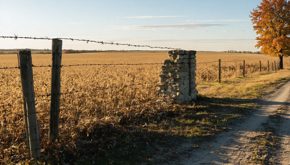
You’ll find Gurney’s ghost town site at coordinates 39.8847°N, 90.2156°W along Illinois Route 125 in Cass County’s Ashland Township, roughly between Philadelphia and Ashland. This vanished prairie settlement left no standing structures—only a single photograph of its 1883 school building survives as visual evidence. Railroad routing decisions and agricultural shifts caused the gradual population exodus. The 8-mile stretch of Route 125 follows the historic Sangamon Trail alignment, where overgrown areas might conceal cemetery remnants and artifacts from this completely disappeared community’s past.
Key Takeaways
- Gurney is a ghost town in Ashland Township, Cass County, accessible via Route 125 between Philadelphia and Ashland.
- The site coordinates are 39.8847°N, 90.2156°W, approximately 8 miles along Route 125’s historical Sangamon Trail alignment.
- No buildings or roads remain; only a single photograph of Gurney School documents the vanished prairie settlement.
- The town declined after railroads bypassed it, causing gradual population exodus and economic collapse from lost transportation access.
- Possible remnant cemeteries may exist in overgrown areas, with potential historic artifacts near Route 125.
Where to Find Gurney in Cass County
When you’re planning your route, remember that Cass County’s western edge follows the Illinois River, providing a natural landmark.
The county seat of Virginia sits centrally for reference, while major thoroughfares like Illinois Routes 78 and 67 complement Route 125’s direct path to Gurney’s historical site.
What Remains of This Lost Illinois Town
Although Gurney maintains its designation as a ghost town in Ashland Township with an official GNIS feature ID of 422767, virtually nothing of the original settlement survives today.
The site has returned to its natural state, with no documented buildings, roads, or infrastructure marking where the community once stood. Your exploration will reveal farmland rather than ruins. A single photograph of Gurney School provides the only visual record of this vanished settlement.
Like other abandoned Illinois towns, possible remnant cemeteries may exist in overgrown areas, though none are officially confirmed for Gurney. You might encounter undiscovered historic artifacts if you venture off Route 125, as small farming communities typically left behind scattered evidence of daily life before improved transportation drew residents toward larger cities.
How Gurney Became a Ghost Town
Multiple converging forces transformed Gurney from a functioning prairie settlement into one of Illinois’s forgotten communities. Factors contributing Gurney’s abandonment centered on railroad routing decisions that bypassed the town, eliminating essential transportation connections for commerce and population growth. When rail lines favored neighboring settlements, merchants and residents relocated where economic opportunities remained viable.
The agricultural metamorphosis and decline of resource extraction industries further eroded Gurney’s economic foundation. Without transportation infrastructure or sustainable industry, the community experienced gradual population exodus rather than sudden collapse.
Today, preservation efforts for Gurney’s ruins remain minimal, with only scattered remnants marking where buildings once stood. Historical records archived in Cass County document this lost community, reflecting broader patterns that created numerous Illinois ghost towns during industrial transformation periods.
Mapping Your Route Along Illinois Route 125
The Philadelphia to Ashland stretch of Illinois Route 125 covers approximately 8 miles through Cass County’s agricultural heartland, passing near the Jim Edgar Panther Creek State Fish and Wildlife Area.
You’ll find Gurney’s remnants positioned between these two communities at coordinates 39.8847°N, 90.2156°W, accessible via unmarked county roads intersecting the highway. This segment retains its historical alignment along the Sangamon Trail, with minimal commercial development since the route’s 1968 extension to Beardstown.
Philadelphia to Ashland Stretch
As you travel eastward from Philadelphia, Illinois Route 125 carries you through 37.10 miles of central Illinois countryside that’s remained largely unchanged since 1969. This stretch takes you directly to Ashland, traversing the heart of Cass County without multiplexing or designation changes.
The historical origins of Illinois Route 125 trace back to its 1968 extension from Springfield to Beardstown, replacing portions of U.S. Route 67 and Illinois Route 3. You’ll follow most of the historic Sangamon Trail, a pioneer route connecting Springfield to the Illinois River.
The picturesque rural landscapes along the route reveal mile markers dotting agricultural terrain, while Jim Edgar Panther Creek State Fish and Wildlife Area lies northwest of your destination. This east-west corridor connects county seat Virginia with surrounding communities.
Rural Landmarks and Coordinates
Gurney’s precise location at 39°53′57″N 90°03′00″W (39.89917°N, 90.05000°W) places this ghost town directly along Illinois Route 125 in Ashland Township, Cass County. At 630 feet elevation, this GNIS-documented site (ID: 422767) serves as a critical waypoint between Philadelphia and Ashland.
Navigation Reference Points:
- ZIP Code 62612 – Use for GPS routing and local mapping accuracy
- IL Route 125 – Primary access corridor through central Illinois farmland
- Abandoned buildings – Visible structural remains mark the settlement’s historical footprint
- Decimal coordinates 39.89917, -90.05000 – Precise positioning for digital navigation systems
Local preservation efforts have documented Gurney’s decline following improved transportation networks. The site’s rural positioning offers unrestricted exploration opportunities for travelers seeking authentic historical experiences beyond regulated tourist destinations.
The Historic Gurney School Structure

In 1883, Warren Township established its first permanent educational facility in the Gurnee area, marking a significant investment in the community’s growing infrastructure. The single-building structure featured substantial grounds with multiple trees, demonstrating the historical significance early settlers placed on education. While specific construction materials remain undocumented in available archives, the building’s design prioritized permanence and capacity for multi-grade instruction.
The original school served Warren Township’s expanding population for approximately twenty-five years before becoming obsolete. Today, documentation gaps prevent researchers from determining the structure’s exact fate or current site conditions, leaving this educational landmark largely forgotten in Gurnee’s transformation from rural settlement to modern community.
You’ll find limited records about this predecessor to the 1908 consolidated facility, which housed both elementary and high school operations.
Other Abandoned Towns Worth Visiting Nearby
While exploring Gurney in Cass County, you’ll find several other vanished settlements within driving distance that offer distinct historical narratives.
Brownsville, now completely erased except for historical markers and iron kettles from Dr. Will’s salt works, lies in southern Illinois near the region’s salt production heritage.
Cairo, positioned at the state’s southern tip where the Mississippi and Ohio rivers meet, stands as Illinois’s most dramatic ghost town—a once-prosperous river port now largely abandoned, with empty structures marking its decline from racial violence and economic collapse.
Notable Cass County Sites
- Most disappeared through economic decline rather than dramatic events
- Cemetery locations often provide sole physical evidence of former communities
- Private property boundaries require respectful reconnaissance and landowner contact
- Informal settlements like Poverty Ridge operated around single structures—typically schoolhouses
Regional Ghost Town Highlights
Beyond Gurney’s boundaries, Cass County and surrounding regions contain dozens of vanished settlements that share similar abandonment patterns. Brownsville disappeared completely when railroads bypassed it, leaving only iron kettles from Dr. Will’s salt works and weathered tombstones.
You’ll find Griggsville Landing transformed from river commerce hub to grass fields, its demolished streets and neighborhoods now wood lots accessible for exploration. Fermalap’s undocumented village relics include surviving fence structures and gravestones marking where farmland yielded to scientific advancement.
Cairo represents Mississippi River town decline—once-booming, now eerie and mostly abandoned. Vishnu Springs joins ten other documented ghost towns across Illinois prairies, their forgotten histories emerging through recent preservation efforts. These sites offer tangible evidence of community promise lost to economic shifts and infrastructure decisions.
Understanding Why Illinois Towns Disappeared

Several distinct forces converged to erase once-thriving Illinois communities from the map, each leaving behind abandoned buildings and fading memories.
Economic shifts, environmental catastrophes, and human conflict transformed bustling Illinois settlements into hollow shells of their former prosperity.
You’ll discover four primary causes behind Illinois ghost towns:
- Transportation Evolution – Railroads bypassed river ports like Cairo and New Philadelphia, stripping them of trade routes and triggering demographic changes that reduced populations by over 80%.
- Natural Disasters – Repeated Ohio and Illinois River flooding devastated Shawneetown and Griggsville Landing, forcing residents to relocate or abandon their homes entirely.
- Resource Depletion – Coal mining exhaustion left Benld, Brownsville, and Eldred struggling without economic diversification, their populations dwindling as underground reserves vanished.
- Social Upheaval – Racial tensions and violence drove mass exodus from Cairo, where discrimination and civil unrest destroyed community stability throughout the 20th century.
Best Times and Seasons for Ghost Town Exploration
Spring and fall present the most favorable conditions for exploring Illinois ghost towns like Gurney, with temperatures ranging from 50-70°F and reduced vegetation growth that reveals structural remains obscured during summer months. These seasons deliver ideal weather conditions that allow extended outdoor investigation without extreme heat or winter ice limiting your movement. You’ll find accessible routes easier to navigate when ground conditions remain firm but not frozen.
Summer’s dense foliage conceals historical foundations and artifact locations, while winter’s harsh conditions create safety hazards around deteriorating structures. Mid-April through May and September through October offer prime visibility for photography and artifact documentation. Plan your expedition during weekday mornings to avoid potential interference and maximize your autonomous exploration of these abandoned settlements.
What to Look for When You Arrive

When you reach Gurney’s location along IL Route 125 between Philadelphia and Ashland in Cass County’s Ashland Township, you’ll need to identify subtle markers since no substantial buildings survive. The Gurney School, documented in historical photographs, serves as the primary structural reference point, though you’ll find mainly foundations and scattered debris rather than intact walls.
Tree-lined rural roads that once connected this community still trace visible paths through the landscape, offering your best navigation tool for locating where buildings and gathering spaces once stood.
Gurney School Structure Remains
Here’s what you’ll discover at the former school location:
- Open parkland with soccer fields where classrooms once stood
- Walking paths traversing land that educated students from 1838 through 2013
- A shelter structure marking the space where generations learned
- Deed-restricted open space funded by a $3.2M federal grant, ensuring permanent preservation
The 2004 flooding—worst in 100 years—ultimately sealed the school’s fate. Former students salvaged bricks as mementos before the final demolition, carrying forward tangible pieces of their educational heritage.
Rural Roads and Markers
Illinois Route 125 provides your primary navigation corridor for locating Gurney’s remnants, running directly through the former town site between the communities of Philadelphia and Ashland. You’ll find the Ashland Township designation still marked on contemporary maps, serving as your geographical reference point at 630 feet elevation.
Field conditions vary substantially throughout the year—cracked asphalt streets become most visible during seasonal changes when vegetation dies back or gets cleared. Look for historical markers indicating former settlement boundaries along the route.
Tree lines frequently reveal old property divisions and pioneer-era roadways, while curved, irregular pavement patterns distinguish original settlement routes from modern highway alignments. Compare current road layouts against historical maps to pinpoint exact former locations within this reclaimed agricultural landscape.
Documenting Your Visit to Gurney
As you approach this remote ghost town along Illinois Route 125, proper documentation requires methodical attention to the landscape between Philadelphia and Ashland. The Gurney School remains serve as your primary photographic subject, representing Ashland Township’s abandoned educational infrastructure. Before checking drone aerial photography or surveying property borders, respect private land boundaries.
Essential Documentation Steps:
- Roadside photography – Capture Route 125 corridor views without trespassing on adjacent farmland
- Township markers – Record any surviving boundary indicators or historical signage
- School structure remnants – Photograph remaining architectural elements from public vantage points
- Coordinate logging – Mark precise GPS locations for archival reference and future verification
Dr. Neil Gale’s compiled records provide baseline comparison for your field observations of this Cass County ghost town.
Frequently Asked Questions
Is Permission Required to Access the Gurney School or Private Property?
You’ll need private landowner permission before accessing Gurney School property. Historic preservation concerns mean trespassing risks legal consequences. Forest preserve hours require Executive Director approval for outside visits. Always respect property rights when exploring abandoned sites.
Are There Any Safety Hazards to Watch for at Abandoned Sites?
Yes, you’ll face hazardous structures like unstable roofs and rotted floors that caused Sheffield’s fatal hotel collapse. Watch for wildlife encounters in abandoned buildings—raccoons, snakes, and bats commonly nest inside. Test footing carefully and bring proper lighting for safe exploration.
Can I Camp Overnight Near Gurney or Surrounding Ghost Towns?
You’ll find nearby lodging options at Giant City State Park and Shawnee Forest Campground, both within driving distance. However, camping directly at Gurney isn’t recommended due to historical preservation efforts protecting the abandoned site’s remaining structures.
What Cell Phone Coverage Can I Expect in Rural Cass County?
You’ll find virtually bulletproof carrier signal strength with AT&T’s 100% Cass County coverage, while Verizon delivers 93.4% reach. Data connectivity options prove strongest with these two carriers, though rural 5G remains inconsistent for off-grid exploration.
Are There Guided Tours Available for Illinois Ghost Town Exploration?
Illinois ghost towns like Gurney don’t offer organized group excursions, so you’ll experience self-guided tours instead. You’re free to explore independently, though established ghost tours operate in Chicago, Galena, Springfield, Elgin, Alton, and Rock Island for paranormal experiences.
Exploring ghost towns in Nebraska can be equally intriguing, offering a glimpse into the past with their abandoned buildings and quiet streets. Many of these towns have rich histories, making them perfect for those looking to discover forgotten stories and landscapes. As you wander through these once-thriving communities, you might even stumble upon remnants that hint at the lives lived there long ago.