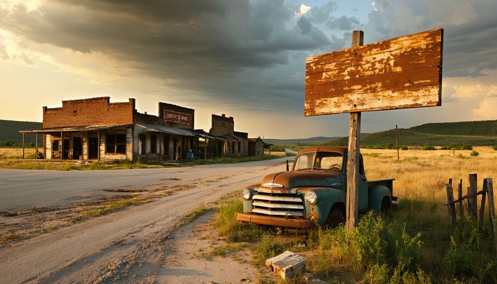
You’ll need to venture nine miles southeast of Ardmore into Carter County’s unmarked backcountry, where Hoxbar’s ghost awaits along rough gravel roads that’ll test your navigation skills. Download offline maps and GPS coordinates before you lose cell coverage, and check ODOT advisories since seasonal washouts can strand the unprepared. This cattle-brand settlement turned oil boom town offers authentic ghost-town hunting—no signs, no crowds, just you tracking the faint footprints of John Washington’s 1895 HOX-branded legacy through terrain that rewards the persistent explorer.
Key Takeaways
- Hoxbar is located nine miles southeast of Ardmore in Carter County’s rural backcountry with unmarked gravel roads.
- Download offline maps and note GPS coordinates beforehand, as cell coverage is minimal and standard navigation apps lack data.
- Road conditions beyond Ardmore are unpaved and prone to seasonal washouts; check ODOT daily advisories before departure.
- Look for old township markers near Humphreys or Jackson for orientation, as formal trail markers don’t exist.
- Prepare for rough terrain with little infrastructure; the journey requires self-reliance and acceptance of navigational uncertainty.
Understanding Hoxbar’s Forgotten History in Carter County
When you drive seven miles southeast of Ardmore through Carter County’s rolling terrain, you’ll find precious little evidence that a town called Hoxbar once thrived here. The post office operated from 1895 to 1926, serving settlers who’d claimed land in what was then Pickens County, Chickasaw Nation.
You’re standing in territory transformed by the 1913 Healdton field discovery, when Wirt Franklin’s No. 1 well struck oil at just 1,000 feet. That strike’s social significance reshaped the entire region—Ardmore became an oil hub overnight, and 2,448 wells eventually dotted these counties. The Healdton field ultimately produced over 230 million barrels from the Hoxbar Formation’s sandstone beds, making it one of Oklahoma’s most prolific conventional oil-producing intervals.
The environmental impact remains visible today: pumpjacks still nod across landscapes where Hoxbar’s citizens once collected mail, their community swallowed by the very petroleum wealth beneath their feet. Carter County is one of several United States counties sharing this name, a designation that reflects the broader pattern of county naming across different states.
From Ox-Bar Cattle Brand to Semi-Abandoned Settlement
Before oil transformed this landscape, John Washington’s “HOX” cattle brand gave Hoxbar its distinctive name—a rancher’s mark that would outlive the community itself. This settlement’s cattle ranching roots trace back to pre-statehood days when ranchers carved their livelihoods from Carter County’s prairie.
A cattle brand outlasted the town it named—rancher legacy etched deeper than any settlement could root.
You’ll find Hoxbar’s story mirrors countless early regional settlements that bloomed and faded:
- October 4, 1895: Post office established, marking official recognition
- Star Route service: Connected isolated ranchers between Ardmore and Marietta
- Red Holt’s rock store: Doubled as mail hub and community anchor
- November 30, 1926: Post office closed, signaling decline
The settlement clung to the Love-Carter County line for decades before abandoning its purpose. Today it remains semi-abandoned, a whisper of independence-minded ranchers who needed neither crowds nor permission. While Hoxbar faded quietly, other Oklahoma oil fields left behind thousands of orphan wells that continue leaking methane and toxic materials decades after operators abandoned them. Nearby Gene Autry, originally called Lou in 1883, lies seven miles east of Springer and underwent multiple name changes before adopting its famous moniker in 1942.
Economic Forces That Built and Broke This Prairie Community
Two economic waves crashed across this prairie—agriculture built Hoxbar, then oil briefly revived it before abandoning the settlement to silence.
You’ll trace Hoxbar’s rise to Oklahoma’s 1890s population explosion, when 790,000 settlers doubled the territory through cotton and livestock farming. Railroads like the Missouri, Kansas and Texas Railway sparked coal mining and timber operations, diversifying the eastern economy. By 1930, personal income had surged from $90 million to $1 billion statewide. Agricultural employment’s share plummeted from 70% in 1900 to just 37% by 1930 as trade and technical occupations expanded.
Then came the oil boom collapse. The 1980s energy crash mirrored Great Depression devastation, halving per capita incomes overnight. Railroad infrastructure decline severed Hoxbar’s lifeline to markets. When vertical drilling proved inconsistent in the Hoxbar formation, operators moved elsewhere. Modern operators like Lynx Oklahoma Operating LLC are now developing the Hoxbar/Marchand as a new horizontal target, with initial wells producing 225,000 barrels in 30 months through advanced completion techniques. Today’s horizontal renaissance targets deeper formations, leaving this ghost town to tumbleweeds and memories.
You’ll need to plot your course carefully before leaving Ardmore’s city limits, as Hoxbar won’t appear on your GPS or modern maps. The nine-mile journey southeast takes you into Carter County’s rural backcountry, where unmarked gravel roads branch off the main routes and historical landmarks have long since vanished into prairie grass.
I recommend downloading offline maps, noting your GPS coordinates at key intersections, and watching for old township markers near Humphreys or Jackson that might orient you toward where the Ox-Bar community once stood. Unlike nearby America, which you’ll find at the junction of D2225 and N4780 in the Ouachita National Forest, Hoxbar’s location requires more detective work to pinpoint. America now shows piles of rubble and a few buildings without roofs, giving you a preview of what neglected sites look like in this region.
Route Planning and Landmarks
Getting to Hoxbar requires traversing a nine-mile stretch southeast from Ardmore through Carter County’s rolling prairie landscape. You’ll need to rely on historical coordinates since modern GPS won’t recognize this forgotten settlement.
The route lacks formal trail markers, so you’re fundamentally following the ghost’s footprint through open country.
Essential navigation points:
- Study topographical maps showing the area nine miles southeast of Ardmore’s center
- Watch for remnants of old ranch roads bearing toward the original Ox-Bar cattle brand territory
- Document wildlife sightings—hawks, deer, and coyotes still roam these untamed grasslands
- Prepare for rough terrain with minimal infrastructure or cell coverage
You’re heading into authentic Oklahoma backcountry where freedom means self-reliance. Like many of Oklahoma’s approximately 2,000 ghost towns, Hoxbar vanished due to the economic shifts and challenges that swept through the state. Many settlements were bypassed by highway systems, leaving them isolated and eventually abandoned. Pack water, download offline maps, and embrace the uncertainty of hunting vanished places.
Road Conditions and Safety
Before you set off toward Hoxbar’s ghost, understand that this nine-mile journey doesn’t follow maintained highways—you’re venturing beyond where ODOT’s traffic cameras and road sensors reach. ViaMichelin and Waze won’t show real-time updates for these forgotten routes, and WeatherBug confirms there’s no traffic cam coverage near Hoxbar itself.
Driver caution becomes your primary navigation tool here. Check ODOT’s daily advisories before leaving Ardmore, but expect unpaved stretches, overgrown paths, and seasonal washouts closer to the ghost town. The Oklahoma Road Condition Map marks major highways, yet these backroads exist in the gaps between official monitoring.
Cell service weakens as you distance yourself from civilization. Note local emergency services contacts beforehand—you’re genuinely on your own out there, exactly how true adventurers prefer it.
GPS Coordinates and Mapping
Punching Hoxbar’s coordinates into your GPS—34.07093° N, 97.03918° W—marks the exact spot where this ghost town sleeps nine miles southeast of Ardmore, though your device might hesitate before plotting a route to nowhere. Modern mapping applications struggle with settlements that vanished decades ago, but you’ve got options beyond the beaten path.
- OpenStreetMap recognizes Hoxbar (node 151926657) where commercial apps draw blanks
- Plus code 86643XC6+98 works across all platforms when street addresses fail
- Aerial imagery reveals field patterns and remnant foundations invisible from ground level
- TopoZone’s 820-foot elevation marker confirms you’re traversing the right patch of Great Plains emptiness
Download offline maps before leaving Ardmore—cell towers don’t care about your adventure into Oklahoma’s forgotten corners.
What Remains at the Site Today
When you finally reach Hoxbar’s coordinates, you’ll find nature has reclaimed most of what once stood here—scattered foundation stones peek through tall prairie grass, and if you’re lucky, you might spot the crumbling remains of an old cellar or chimney.
The site sits on private property, so you’ll need to view it from the roadside, where overgrown vegetation and the lack of clear markers make identifying specific structures nearly impossible.
Bring a good camera with a zoom lens, because the best remnants often hide in the tree line, visible only to those who know exactly where to look.
Physical Structures and Remnants
The landscape of Hoxbar tells its story through absence. You’ll find concrete foundations stretching across empty lots where neighborhoods once thrived, their architectural styles now reduced to geometric footprints in overgrown grass. These symbolic remnants of former community life mark where families built dreams before abandonment claimed the town.
As you explore, you’ll encounter:
- Abandoned houses with orange demolition marks, their sagging frames too dangerous to enter
- Collapsed structures scattered in clusters, their dark windows and sealed doors evidence of sudden evacuation
- Building foundations lined along empty streets, strewn with personal objects that hint at hurried departures
- Specific landmarks like the shuttered Picher-Cardin High School building, standing sentinel over ghost town silence
Each remnant whispers tales of lives interrupted and a community forever changed.
Access and Visibility Challenges
Unlike more accessible ghost towns along Oklahoma’s highways, Hoxbar presents a formidable challenge for even the most determined explorer. You won’t find roadside markers or heritage signs pointing the way—minimal signage visibility means you’re traversing by instinct and historical fragments alone.
The southeastern Carter County location near Lake Murray compounds the difficulty, as reservoir development likely swallowed portions of the original settlement.
The sparse population density in this region works against you. What few remnants exist—weathered stone foundations, overgrown cemetery plots—blend seamlessly into private ranch land where public access isn’t guaranteed. You’ll need property owner permission, GPS coordinates from historical vignettes, and patience to locate anything substantial. This isn’t a casual stop; it’s an expedition into Oklahoma’s forgotten corners.
Combining Hoxbar With Nearby Oil Field Ghost Towns

For maximum efficiency, you’ll want to cluster Hoxbar with at least two or three oil field ghost towns within a 50-mile radius, creating a full-day loop through Carter County and beyond.
Before setting out, research land ownership status for each site—you don’t want trespassing charges derailing your adventure. The Cushing area offers several abandoned boom towns where oil derricks once pumped black gold. Consider these essential stops:
- Earlsboro’s remnants showcase theatrical foundations and hotel ruins from its 1920s oil surge
- Slick’s ghost infrastructure reveals Tom B. Slick’s rapid-growth empire now returned to prairie
- Environmental impacts remain visible through contaminated soil and rusted equipment
- Stone foundations and cemeteries mark settlements that vanished within decades
Pack water, wear boots, and download offline maps—cell service disappears where these towns once thrived.
Essential Safety Considerations for Backroad Exploration
Check your spare tire and fuel levels religiously.
Cell service vanishes between ghost towns, leaving you genuinely isolated.
Freedom means self-reliance, not recklessness.
Private Property and Land Access Guidelines
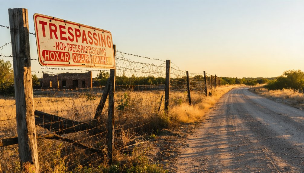
Most ghost town remnants in Carter County sit squarely on private land, and Hoxbar’s no exception. You’ll need to track down landowner permissions before stepping foot on the site. Oklahoma’s trespassing laws don’t bend for curious explorers, and these rural oil field properties often have gates and signage marking boundaries.
Before you venture out:
- Scout nearby roads like N4540 RD to identify property lines and potential access points
- Contact Carter County records to determine current ownership of parcels near the coordinates
- Approach landowners in person when possible—showing respect goes miles further than a phone call
- Never assume semi-abandoned means open access—structures and land still belong to someone
Getting proper site permissions transforms you from trespasser to welcome guest. That freedom’s worth the extra legwork.
Best Times and Seasons to Visit Carter County Remnants
Timing your Carter County ghost town expedition means dodging Oklahoma’s most brutal weather extremes while catching the landscape at its most revealing. You’ll find September through November delivers ideal conditions—dry gravel roads, comfortable 70°F days, and minimal vegetation concealing Hoxbar’s stone foundations.
Spring’s March-May window offers accessibility via Highway 7, though localized weather patterns bring tornado warnings and mud-choked access roads.
Winter’s bare landscapes expose cemetery markers perfectly for seasonal photography opportunities, but ice storms can trap you on secondary routes.
Summer? Skip it unless you’re masochistic about 100°F+ heat waves. Fall’s low humidity preserves weathered signage best, and you’ll avoid the Halloween tour bus crowds if you visit mid-September during Carter County Fair week when locals celebrate their vanished oil boom heritage.
Frequently Asked Questions
Are There Any Historical Photographs or Documents of Hoxbar Available Online?
You’ll find historical records through Gateway to Oklahoma History’s online archives, including a circa-1900 Hoxbar school photo and documents about the town’s name origins. Pastmaps.com also offers six detailed historic maps spanning 1901 to present.
What Was the Peak Population of Hoxbar Before Its Decline?
Hoxbar’s former population numbers peaked at 5,380 residents in 1950, when the town’s economic history centered on thriving cotton production, wheat farming, and cattle ranching. You’ll find it’s been declining ever since that postwar high.
Can You Camp Overnight Near the Hoxbar Site Legally?
You can’t legally camp at Hoxbar itself—it’s private land. Check local regulations first, then head to campsites nearby like Lake Texoma State Park. Always get landowner permission before pitching your tent on someone’s property.
Are There Local Historians or Descendants Who Conduct Tours of Hoxbar?
You’re barking up the wrong tree—no local historians or descendants conduct Hoxbar tours. The site lacks local community involvement and cultural preservation efforts, leaving you free to explore independently through Carter County’s uncharted backroads and forgotten landscapes.
What Specific Landmarks Help Identify the Original Hoxbar Town Boundaries?
You’ll spot Hoxbar’s original boundaries through remnant building foundations scattered along forgotten street grids and abandoned infrastructure elements like old well casings, fence posts, and crumbling stone markers that once defined this frontier settlement’s edges.
References
- https://www.beaversbendcreativeescape.com/se-oklahoma-ghost-towns/
- https://kids.kiddle.co/List_of_ghost_towns_in_Oklahoma
- https://www.youtube.com/watch?v=BH3RSXTWdOo
- https://oklahomahistory.net/vol-28-issue-1418-april-4-2024/
- https://freepages.rootsweb.com/~gtusa/history/usa/ok.htm
- https://echo.snu.edu/the-ghost-towns-of-oklahoma/
- https://gateway.okhistory.org/ark:/67531/metadc1627223/
- https://abandonedok.com/class/disappearing-town/
- https://www.kingdomexploration.com/?page=geo-review&slug=hoxbar-formation
- https://www.ou.edu/content/dam/ogs/documents/presentations/1-Seyedolali – Project Summary-Nov14.pdf


