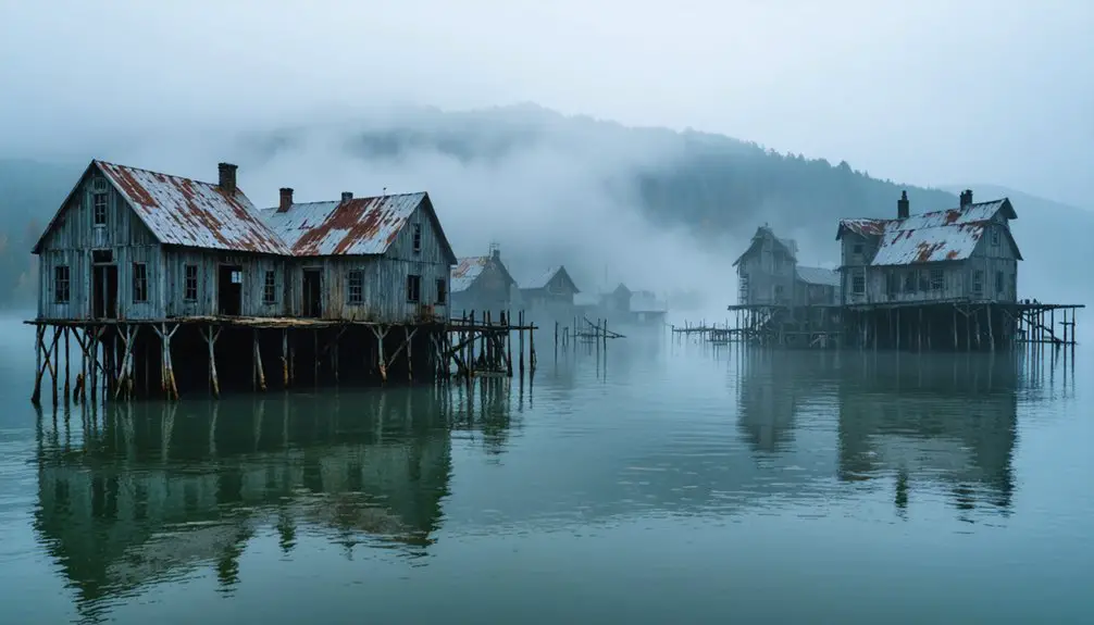
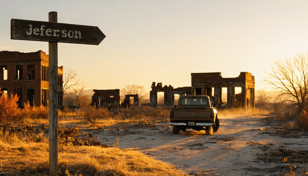
You’ll find Old Jefferson’s ruins scattered through dense woodland barely a mile from Percy Priest Lake’s shoreline, accessible year-round because the Army Corps of Engineers miscalculated the reservoir’s final depth by dozens of feet. Stone foundations, cellar staircases, and skeletal roadbeds emerge from forest regrowth where Tennessee’s first Rutherford County seat once thrived before federal bulldozers arrived in the 1960s. The town that was supposed to vanish beneath flood waters refuses to disappear, and its preserved remains hold secrets worth discovering.
Key Takeaways
- Old Jefferson’s ruins lie near Percy Priest Lake’s shoreline, accessible through dense woodland with visible stone foundations and road outlines.
- Visit during summer drawdowns for maximum visibility of demolished foundations, cellars, and scattered stone walls throughout the townsite.
- The town disappeared in the 1960s for dam construction, but miscalculated flood depths preserved ruins above water year-round.
- Explore stone staircases, building mounds, and skeletal roadbeds now hidden beneath decades of forest regrowth near the lake.
- No official markers exist; historians warn undiscovered grave sites may scatter throughout the abandoned townsite’s archaeological remains.
The Rise and Fall of Tennessee’s Lost County Seat

When Robert Weakley deeded land at the fork of the Stones River in February 1806, he formalized what was already a thriving settlement with grand ambitions. You’ll discover Jefferson served as Rutherford County’s first seat from 1804, strategically positioned as an envisioned inland port connecting to the Mississippi River. The town’s public square buzzed with taverns, stores, and a saloon on every corner, shipping cotton, corn, and tobacco downriver to New Orleans.
But by 1811, Jefferson lost its courthouse to centrally-located Murfreesboro. The local economy shifts followed: the courthouse became Jefferson Seminary, and the farm community’s decline accelerated through the twentieth century. Cotton fields gave way to dairy farms as population dwindled, transforming this once-lively hub into Tennessee’s forgotten county seat.
How a Dam Project Erased an Entire Town
As the 1960s dawned, Jefferson’s fate shifted from slow decline to deliberate erasure when the U.S. Army Corps of Engineers arrived with eminent domain paperwork for the J. Percy Priest Dam project. Beginning in 1963, residents learned their homes would vanish beneath reservoir waters meant for flood control and hydroelectric power.
The community displacement unfolded methodically—houses moved or sold with relocation requirements, non-movable structures burned, everything else bulldozed flat. Within four and a half years, an entire town disappeared. Residents scattered, their social fabric torn apart by engineered necessity.
Yet here’s the bitter irony: the social impact of flooding never materialized. Underground caves diverted the rising waters, leaving Old Jefferson’s razed foundations high and dry—a ghost town destroyed for submersion that never came.
The Flood That Never Came: A Engineering Miscalculation
The U.S. Army Corps of Engineers’ oversight failures transformed Hurricane Katrina from natural disaster into America’s worst engineering catastrophe. You’ll discover how design flaws decimated New Orleans in 2005—engineers never accounted for a fifty-foot sand layer beneath flood walls, allowing seepage that reduced structural integrity to just fifty percent.
They misinterpreted survey data, installed sheet piles too short for adequate support, and built levees without proper foundational analysis. When storm surge reached 1.7 feet above the walls, overtopping created waterfalls that eroded earthen levees three feet deep. Fifty breaches followed. The $738 million system failed spectacularly, killing 1,392 people and causing $190 billion in damage.
The Lower Ninth Ward vanished beneath twelve feet of water—proof that bureaucratic incompetence drowns freedom faster than any hurricane.
What Remains at the Jefferson Townsite Today
You’ll find Jefferson suspended in time above the waterline that was supposed to erase it—stone walls jutting from leaf litter, stairways descending to collapsed cellars, the skeletal grid of roadbeds visible beneath decades of forest regrowth.
The Army Corps bulldozed this Rutherford County seat in the 1940s, burning what remained after families dismantled their homes, yet the town’s bones refused to disappear beneath Percy Priest Lake’s miscalculated flood zone. Today, these foundations rest in quiet woods near Long Hunter State Park, accessible to those willing to navigate unmarked trails where Google Maps has revealed what official histories tried to submerge.
Foundations in the Forest
Wandering through the dense Tennessee forest where Jefferson once thrived, you’ll discover stone foundations rising from the leaf-littered earth like forgotten monuments. These timber frame foundation remains outline where families built their dreams before the reservoir claimed their town.
Your exploration reveals:
- Mossy cellar staircases descending into caved-in darkness, their stone steps worn smooth by generations of footfalls
- Scattered stone walls marking property boundaries that no longer matter
- Demolished building mounds hidden beneath decades of forest growth
- Overgrown cellar holes where provisions once stayed cool through summer heat
Each foundation tells its own story—a merchant’s shop here, a family home there. The U.S. Army Corps of Engineers manages this landscape now, preserving these architectural ghosts for adventurers seeking tangible connections to Tennessee’s submerged past.
Cemeteries Still Standing
Unlike the ghost towns of Wilder or Wheat where weathered headstones still pierce the forest canopy, Jefferson’s cemetery remains prove frustratingly elusive. You’ll find no marked burial grounds among the stone foundations and collapsed walls—just whispered possibilities in forested clearings. When the Army Corps razed structures in the 1940s, they left no record of relocating bodies, unlike other dam projects.
Historians believe undiscovered grave sites scatter throughout the townsite, particularly near the original courthouse square where Rutherford County’s earliest settlers rested. Family cemetery preservation simply didn’t happen here; generations of farm families lost their ancestral grounds without ceremony. Today, overgrown patches might conceal pioneer graves, Trail of Tears interments, or forgotten family plots—all reclaimed by Tennessee wilderness, their stories buried deeper than their stones.
Accessing the Ruins
The ruins of Jefferson lie scattered through dense woodland near Percy Priest Lake’s shoreline, their locations maddeningly difficult to pinpoint despite the town’s complete demolition in the early 1960s. Traversing unmarked trails requires determination, as summer briars and greenery obscure what little remains.
Self guided tours reveal:
- Demolished building mounds rising from the forest floor where structures once stood
- Faint road outlines traceable through overgrown vegetation
- Foundation remnants scattered throughout the wooded terrain
- Artifact-filled dumpsites containing rusty cans and bottles from daily life
Access the site by entering woods from Percy Priest’s shores, following the Trail of Tears path toward former home sites. Open fields punctuate tree stands across this eerie landscape, where generational farms vanished unnecessarily due to engineering miscalculations about water levels.
Getting to the Ghost Town: Access Points and Trails
Reaching Jefferson requires determination and a willingness to bushwhack through Middle Tennessee’s reclaimed woodlands. You’ll find access through Long Hunter State Park, where the Trail of Tears route—rediscovered in 2014-2015—cuts through the former town site approximately 30-35 miles from Murfreesboro.
Navigation demands careful attention: original road beds lie beneath forest growth, while stone walls and abandoned foundations serve as waypoints through dense vegetation. Summer’s thick canopy obscures most structural remains, though vegetation removal efforts have revealed uncovered artifacts scattered among dumpsites filled with rusty cans and bottles.
Vehicle access reaches the general vicinity, but expect significant hiking through overgrown sections to locate specific ruins. Stairs descending into collapsed cellars and visible mounds mark where buildings once stood.
Best Times to Visit the Dry Ruins
You’ll find the ghost town’s weathered structures most accessible during fall and winter months, when Douglas Lake’s seasonal drawdown exposes foundations that summer’s full pool submerges beneath twenty feet of water.
The crisp air of November through March not only guarantees dry passage to crumbling walls and rusted machinery, but also delivers the slanted golden light that transforms decaying timber into photographer’s gold—dawn’s first rays particularly dramatic across exposed lakebed and skeletal remains.
Spring’s rising waters gradually reclaim the ruins by late April, making early May your final window before another cycle drowns Jefferson’s drowned past until autumn’s reveal.
Seasonal Water Level Patterns
When U.S. Army Corps of Engineers miscalculated Percy Priest Lake’s final depths, they unknowingly preserved your freedom to explore Old Jefferson year-round. The reservoir management considerations that drain excess water into Long Hunter’s cave systems keep these ruins perpetually accessible, defying the 1960s submersion forecasts that scattered an entire community.
You’ll find minimal water level fluctuations affecting the dry townsite:
- Spring runoff slightly raises lake edges but never reaches projected heights
- Summer drawdowns expose maximum ruin visibility for exploration
- Fall stabilization maintains consistent access to demolished foundations
- Winter levels remain predictable, avoiding historical flooding predictions
Unlike drowned ghost towns elsewhere, Jefferson’s accidental preservation means you’re not racing against seasonal submersion—just vegetation growth obscuring your view of freedom’s unintended monument.
Weather and Trail Conditions
The ruins of Old Jefferson demand strategic timing, as Tennessee’s fickle weather patterns can transform accessible foundations into muddy quagmires within hours. You’ll find ideal self guided walking tours during late spring’s 68°F-73°F highs with broken clouds overhead—nature’s perfect archival light for photographing crumbling stonework.
Winter presents seasonal safety concerns: freezing rain creates treacherous footing around deteriorating structures, while snow obscures foundation edges. March through May offers your liberation from weather constraints, though you’ll navigate 20% rain shower chances. Avoid visits during 100% precipitation days when quarter-inch rainfall turns pathways impassable.
Clear nights with 39°F lows provide excellent camping opportunities nearby. Those seeking freedom from crowds should target partly sunny 55°F-58°F windows when precipitation drops to 40%, revealing Jefferson’s skeletal remains without interference.
Photography and Lighting Tips
Capturing Jefferson’s spectral remains requires understanding how light interacts with decay across Tennessee’s shifting seasons. Golden hour delivers warm tones that enhance textures on rusted artifacts and crumbling foundations, while winter’s bare canopy exposes hidden homesites impossible to photograph during summer’s dense overgrowth. Your seasonal visit planning determines what you’ll uncover.
Optimal shooting conditions:
- Late fall through early spring maximizes visibility of Trail of Tears markers through leafless woods
- Overcast winter skies provide diffused illumination across forest floor relics without harsh shadows
- Golden hour sessions shortly after sunrise capture dramatic contrasts on demolished buildings
- Low light techniques using tripods prove essential for fog-shrouded morning atmospherics
Avoid midday summer intensity when canopy creates impossible exposure challenges. Winter solstice shortens your window but rewards patience with unprecedented access to Jefferson’s skeletal landscape.
What You’ll Find While Exploring the Abandoned Townsite
Walking through Jefferson today, you’ll encounter an eerie expanse of open fields and reclaimed forest where a thriving river town once stood. The government’s bulldozers erased every structure before the anticipated flooding that never came.
Yet remnants of the past persist if you know where to look: faint road outlines cutting through underbrush, scattered foundation stones marking where homes and businesses once anchored lives. You’ll stumble across rusted cans, broken bottle glass glinting in filtered sunlight, weathered building columns lying half-buried in soil.
These unseen archaeological clues reveal themselves slowly, rewarding patient observers willing to trace what federal maps said would be underwater. The site whispers its defiance—a town destroyed for a miscalculation, now reclaimed by nature’s quiet rebellion.
Combining Lake Recreation With Ghost Town Exploration
You can anchor your boat along the Stones River shoreline where Cherokee prisoners once forded the waters during their 1838 forced removal, then step onto dry land to trace stone foundations and collapsed cellars that federal engineers assumed would rest beneath twenty feet of reservoir water.
The unexpected preservation occurred when unmapped cave systems diverted Percy Priest Lake’s rising waters in 1967, leaving Jefferson’s ruins accessible for terrestrial exploration rather than submerged beneath the dam’s flood control project.
This quirk of geology transformed a planned underwater grave into a dual-access site where morning paddlers become afternoon archaeological explorers without changing locations.
Boating Near Historic Ruins
Launch your exploration following this approach:
- Navigate to Rutherford County shores where the Corps maintains free boat access near the demolition site
- Beach your craft along the riverbanks where caves mysteriously drained the predicted floodwaters
- Hike inland through tree stands concealing stone foundations the Army Corps bulldozed in the 1960s
- Trace faint roadbeds connecting you to the 1802 settlement’s Trail of Tears crossing
The site stands high and dry—a rare ghost town reachable by water yet never claimed by it.
Hiking To Town Foundations
Solid ground beckons once you’ve moored your boat at East Fork Ramp, where a paved road stretches toward the old water pumping station before dissolving into the overgrown horse trails that thread through Jefferson’s ghost.
You’ll navigate paths reclaimed by summer vegetation, each step bringing you closer to overgrown foundations where homes once anchored families to Tennessee soil. The Army Corps manages this land now, leaving you free to explore demolished building mounds and dumpsites choked with briars.
Weathered artifacts—rusty cans, glass bottles—emerge from weeds and poison ivy, tangible remnants of lives interrupted. Since 2012’s rediscovery of the Trail of Tears route, markers guide your journey through this erased town, though you’re forbidden from pocketing history.
The lake glimmers behind you while Jefferson’s bones crumble ahead.
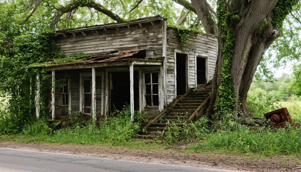
Historic Structures Saved From Jefferson’s Destruction

While Jefferson itself may have faded into history, the determined efforts of local preservationists throughout the 1970s rescued several architectural treasures that now stand as tangible connections to the town’s vanished glory.
The historic buildings restoration movement peaked when citizens launched the Restore Our Courthouse initiative in 1978, ultimately forming the Jefferson County Historical Society. Their historical society initiatives protected:
- Jefferson County Courthouse (1845) – This antebellum structure never suffered fire, preserving complete county records dating to 1792
- Glenmore Mansion (1868) – The southeast’s finest Second Empire architecture, now Jefferson County’s only public house museum
- Mossy Creek Presbyterian Church – Recently NRHP-listed in 2024
- Historic Old City Hall – Now houses the Heritage Center preserving Mossy Creek’s settlement history from 1788
You’ll discover these survivors stand defiant against Jefferson’s disappearance.
Not to Be Confused: Old Jefferson vs. Jefferson City
Tennessee’s mapmakers created lasting confusion when they christened two distinct settlements with nearly identical names, each carving separate destinies along different waterways over a century apart. Historical comparisons reveal stark contrasts: Old Jefferson, founded 1803 on Stones River‘s flood-prone banks in Rutherford County, served briefly as county seat before vanishing beneath Percy Priest Lake’s waters.
Meanwhile, Jefferson City thrived 150 miles northeast in Jefferson County, where settlers established Mossy Creek in 1788 along the Holston River. The cultural significance of these communities diverged dramatically—one drowned by federal acquisition in 1967, the other flourishing as a recreational hub after Cherokee Dam’s completion. You’ll find Jefferson City’s incorporated government still operating today, while Old Jefferson exists only in archival records and submerged foundations.
Frequently Asked Questions
Are There Any Safety Concerns When Exploring the Jefferson Townsite Ruins?
You’ll navigate hazardous terrain riddled with crumbling foundations, toxic vegetation, and rusty debris across this federal property. Dense overgrowth obscures dangers while potential trespassing violations loom—the Corps of Engineers maintains jurisdiction, making exploration legally precarious despite permitted access.
Can You Camp Overnight Near the Ghost Town Area?
You’ll find nearby campgrounds like Cherokee Dam and Anchor Down RV Resort within miles of Jefferson’s ruins. While you’re exploring, consider booking guided ghost town tours to uncover hidden histories before settling into your lakeside campsite for the evening.
Is the Jefferson Townsite on Private or Public Land?
Like forgotten pages scattered across time’s landscape, Jefferson’s remnants rest on uncertain ground. You’ll need to verify land ownership status and obtain access permissions through Rutherford County records, as the townsite’s boundaries between public and private parcels remain unclear.
What Specific Artifacts Have Visitors Found at the Site?
You’ll discover clay marbles, cobalt blue bottles, and ceramic pieces with distinct initials like “WF” and “ML.” While old mining equipment and historical photographs aren’t commonly found, over 400,000 artifacts document this vanished settlement’s poignant story.
Were Any Residents Compensated When Forced to Relocate in the 1960S?
Yes, you’ll find residents were compensated, though forced sales at government-determined prices broke generational ties to ancestral farmland. The reasons for relocation—flood control that never materialized—deepened the impact on displaced residents who’d lost everything for nothing.