You’ll find Jennings in Missaukee County‘s central region near Crooked Lake, though no highway signs mark this vanished lumber town. Visit between May and October when overgrown foundations and empty lots become accessible—early May offers solitude, while late September showcases autumn foliage against weathered remnants. You’ll need sturdy boots, historical coordinates, and patience to locate where 2,000 residents once thrived before the timber ran out in 1922. Seventy Victorian homes survive on Cadillac’s Granite Street, relocated when the Mitchells dismantled their boomtown. The complete story reveals how capitalism’s promise met its expiration date.
Key Takeaways
- Jennings is located in Missaukee County near Crooked Lake; use historical references and old railway routes to navigate.
- Visit between May and October for best accessibility; early May offers fewer crowds, September-October provides stunning foliage.
- Bring sturdy hiking boots, layered clothing, field guides, camera equipment, and geocaching tools for exploring the abandoned site.
- Expect weed-choked empty lots and hidden foundations rather than intact buildings; one church and scattered homesteads remain.
- 70 Victorian homes were relocated to Cadillac’s Granite Street in 1922; the sawmill town was completely dismantled.
The Rise and Fall of a Lumber Boomtown
The sawmill’s rhythmic blade first echoed across Crooked Lake in 1878, when brothers William and James Dewings established a settlement that would define Michigan’s lumber frontier. They pioneered double-cut bandsaw technology, operating beyond lumber industry regulations that would later restrict such unrestricted harvesting.
Austin and William Mitchell purchased the operation in 1882, renaming it Jennings and controlling virtually every structure as a company town. The population surged to 2,000 during the 1890s before the ecological impact of deforestation became undeniable.
Getting to Jennings: Location and Directions
Locating Jennings today requires accepting that this lumber town exists more in historical record than on modern maps. You’ll find its approximate coordinates in Missaukee County’s central area, near Crooked Lake where mills once processed timber. The railroad that enabled lumber transport passed south through Jennings Station, with another stop at Round Lake.
After population decline forced the post office’s closure in 1956, Cadillac became the primary nearby hub, absorbing displaced residents and businesses.
Your journey won’t follow highway signs—they don’t exist for ghost towns. Instead, you’ll navigate using historical references and nearby landmarks like Moores Junction and Sterling. The freedom to explore comes with responsibility: research coordinates, study old railway routes, and understand that authentic discovery means accepting incomplete directions.
What Remains: Victorian Houses and Empty Lots
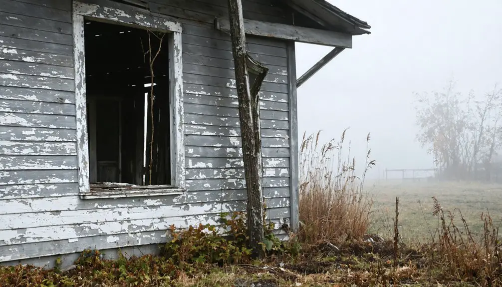
Standing in Jennings today, you’ll encounter a landscape defined by absence rather than presence. Sidewalks lead to weed-choked empty lots where the Mitchell brothers’ sawmill town once thrived. You’ll find foundations hidden in foliage—silent markers of forgotten family histories that vanished when seventy Victorian homes were relocated to Cadillac’s Granite Street around 1922.
One church survives from the original four, alongside scattered old homesteads that owners had paid off before the departure. The cemetery persists as record to 2,000 souls who once called this place home.
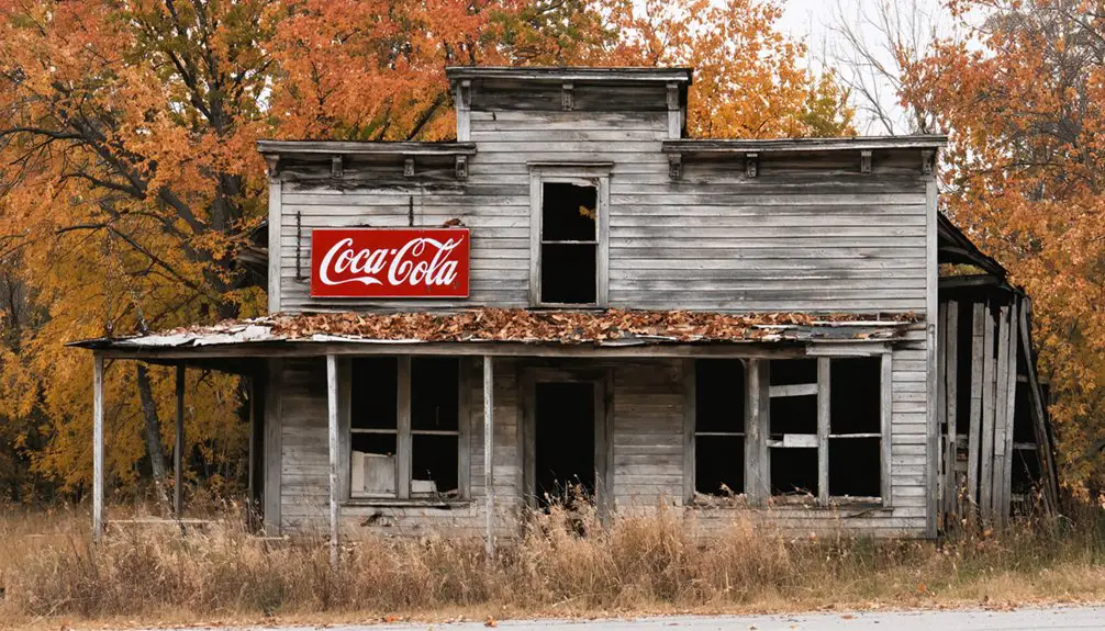
Search the overgrown streets and you’ll discover decaying architectural details—remnants of structures that housed Jennings’ chemical factory, hotel, and businesses during its 1917 peak, before the 1922 demolition erased this timber town’s prosperity.
The Mitchell Brothers’ Legacy
When timber ran out in 1922, the Mitchells didn’t just close shop—they erased Jennings from the map. They demolished the sawmill, relocated equipment to Sault Ste. Marie, and moved 143 houses to Cadillac on special trailers.
What they’d spent decades building, they deconstructed in months. You’re standing where capitalism’s promise met its expiration date, where founders became demolition crews.
Best Time to Visit and What to Bring
Timing your expedition to Jennings requires balancing archival conditions with seasonal accessibility. You’ll find ideal exploration windows from May through October, when weather considerations when visiting align with trail access and documentation opportunities.
Plan your Jennings ghost town visit between May and October when seasonal conditions optimize both trail accessibility and photographic documentation opportunities.
Early May delivers uncrowded conditions and competitive rates, while late September through October provides spectacular foliage against weathered structures—peak periods for authentic ghost town photography.
Pack sturdy hiking boots for forest trail navigation and layered clothing for Michigan’s temperature fluctuations. Bring field guides, camera equipment, and geocaching tools to document architectural details and landscape features.
July demands advance booking despite heat, though seasonal lodging options expand greatly during shoulder seasons. November offers solitude and reduced rates for freedom-seeking explorers willing to brave cooler conditions. Your preparation determines documentary success.
Exploring the Geocaching Site
When you arrive at Jennings Cemetery to locate the GC7YWNM cache, you’ll find the traditional micro container is archived and missing—a reminder that ghost town treasures don’t always endure.
As you walk among the gravestones and weathered foundations, search for historical markers that authenticate this settlement’s brief prominence when 2,000 residents depended on the Mitchell brothers’ enterprises.
Document your visit through photographs and detailed logs that preserve evidence of what remains, contributing to the archival record of Michigan’s vanishing communities.
Finding the GC7YWNM Cache
Located within the historic Jennings Cemetery grounds, cache GC7YWNM—officially designated “MLT – Jennings”—offers geocachers a tangible connection to this settlement’s documented past. The cache placement details specify a clear pill bottle micro container positioned among the cemetery’s weathered markers.
You’ll access the nature of cache clues through Geocaching.com’s encrypted hint system, utilizing a substitution cipher (A=N, B=O) to decode placement information.
Key search parameters:
- Survey the cemetery’s perimeter boundaries where commemorative markers meet overgrown vegetation
- Reference the cipher-decoded coordinates against visible landscape features and surviving headstones
- Inspect areas where micro containers blend naturally with cemetery groundcover and memorial surroundings
Plan your visit during daylight hours—the cache description explicitly recommends avoiding nighttime searches within these burial grounds.
Historical Markers and Clues
Beyond the cache container itself, Jennings’ landscape preserves multiple documentary touchstones that authenticate its once-thriving industrial past. You’ll discover the Jennings Lodge Historical Marker one block west of River Road on Jennings Avenue at Morse Street, featuring photographs and accurate historical accounts of the town’s development. Michigan’s Historical Marker Program has placed over 1,800 permanent marker placements statewide since 1955, each rigorously researched by the Michigan Historical Commission to guarantee authenticity.
As you explore, sidewalks still lead to vacant lots where seventy homes once stood before the Mitchell brothers relocated them to Cadillac. Foundation remnants hide beneath overgrowth throughout the weeded streets, offering physical evidence of Jennings’ 2,000-person peak population. These tangible fragments let you piece together the settlement’s narrative independently.
Recording Your Ghost Town Visit
Upon locating geocache GC7YWNM in Jennings Cemetery, you’ll document your discovery through multiple archival layers that preserve both your personal exploration and the cache’s ongoing narrative.
Documentation Methods:
- Physical Logbook Entry – Sign the clear pill bottle’s logsheet with date, weather conditions, and cache state, creating tangible proof of your presence in this ghost town where population plummeted from 2,000 to near-zero after 1922’s mill closures.
- Digital GPS Record – Capture coordinates, elevation data, and trackside signage description through your geocaching app, building location-specific metadata for future adventurers.
- Visual Archive – Photograph the tree crotch hiding spot and cemetery surroundings without revealing exact placement, then conduct historic photos analysis comparing today’s landscape against Jennings’ lumber-era prosperity.
Rehide exactly as found, maintaining cache integrity for the next independent seeker.
Nearby Attractions in Missaukee County
Your exploration of Jennings needn’t end at the geocaching site—Missaukee County’s preserved landscapes and historical facilities offer authentic connections to Michigan’s recreational heritage.
You’ll find Lake City’s recreation areas maintain the same waters and forests that sustained early settlers, while Cadillac’s historical landmarks document the region’s transformation from frontier outpost to established community.
Crooked Lake’s activities provide direct access to the natural resources that shaped this area’s development, preserving traditional outdoor pursuits within their original setting.
Lake City Recreation Areas
Lake City serves as the recreational hub of Missaukee County, where a network of well-maintained public parks preserves access to the region’s pristine lake systems. You’ll find authentic outdoor experiences across multiple parks, each offering distinct access to waterways and wilderness.
Essential Recreation Areas:
- Missaukee Lake Park – Over 1,000 feet of sandy beach, 100+ campsites with electrical hookups, paved boat ramp with 80 slip rentals, and rustic cabins
- Crooked Lake Park – 600+ feet of beachfront, 52 total campsites (35 with electricity), covered pavilion for gatherings
- Ben D. Jeffs River Park – 66 wooded acres along Muskegon River, canoe launch access, 600+ feet of beach
These parks provide campground amenities and boat rental services without commercial interference, maintaining the region’s historical character while supporting self-sufficient exploration of Michigan’s backcountry waterways.
Cadillac Historical Landmarks
Just fifteen miles south of Lake City, Cadillac preserves an exceptional concentration of documented historical sites that chronicle Michigan’s timber empire and its cultural legacy. Downtown’s National Register buildings stand alongside the unique KISS monument—the world’s only black granite memorial to the band’s 1975 visit. You’ll find authentic lumber transport history preserved through the Shay Locomotive in City Park, which revolutionized inland timber hauling during the 1880s boom.
The Wexford County Historical Society Museum documents Cobbs & Mitchell’s massive mills that processed timber along the lakeshore. Walk the Keith McKellop Walkway connecting these landmarks, or drive the 33-marker Old Indian Trail. Each site offers verifiable documentation of Cadillac’s industrial past, free from commercialized reinterpretation—just preserved structures and authentic historical markers.
Crooked Lake Activities
While most northern Michigan parks offer standard recreational facilities, Crooked Lake’s documented 490.8-acre expanse presents verifiable infrastructure that’s remained largely unchanged since its establishment. You’ll find authentic fishing opportunities across crystal-clear waters that connect through the Inland Waterway system.
The park maintains 35 electrical campsites plus 17 first-come rustic sites, with original hand-pump wells still operational. Boating adventures launch from the permanent paved ramp on the south shore.
Access these preserved amenities:
- Navigate 600+ feet of beach shoreline where calm waters meet marked forest trails spanning 60+ acres
- Launch kayaks into interconnected lakes and rivers forming the historical waterway network
- Observe documented bald eagles and ospreys from wetland vantage points
The covered pavilion and modern sanitation station serve visitors seeking self-sufficient recreation.
Capturing the Ghost Town Experience
Though Jennings’ vibrant lumber-town days ended decades ago, you’ll find photographic and documentary evidence crucial for preserving what remains of this once-thriving community. Capture the solitary church standing among empty lots where three others once served 2,000 residents.
One church remains where four once stood—silent witness to a community of 2,000 now vanished into history.
Document foundations hidden in woods—remnants of homes the Mitchell brothers financed and later relocated to Cadillac. You’ll discover authentic ghost town ambiance through weathered structures contrasting against modern trailer homes and summer cottages.
Seek out descendants at occasional reunions who share local lore about the double-cut bandsaw innovation and chemical factory operations. Photograph the landscape where 600 men once worked daily, transforming Michigan timber into flooring and shingles.
These visual records preserve freedom-seeking settlers’ legacy before nature reclaims what remains.
Frequently Asked Questions
Are There Any Restaurants or Gas Stations Near Jennings?
You’ll find Jennings’ cupboard bare—nearby dining options and local fuel sources are scarce in this ghost town. You must venture to Barryton or Big Rapids for authentic sustenance and gas, preserving your independence through proper trip planning.
Is It Safe to Explore the Old Foundations in the Woods?
Exploring old foundations isn’t safe—you’ll face potential structural instability from century-old construction and presence of wildlife hazards in dense woods. Respect these historical remnants by observing from visible paths only, preserving both the site and your wellbeing.
Can You Enter or Photograph the Remaining Victorian Houses?
You can’t enter the 70 relocated Victorian homes—they’re private residences on Cadillac’s Granite Street. However, you’re free to photograph them from public streets, respecting historic preservation status and local photography regulations governing personal property boundaries.
Are There Overnight Accommodations Available in or Near Jennings?
You’ll find the Talsma Vacation Rentals right on Lake Missaukee, sleeping up to 24 guests in historic comfort. While authentic bed and breakfasts aren’t documented in Jennings proper, nearby Jenison offers several budget-friendly hotel options for your independent exploration.
Do You Need Permission to Visit the Ghost Town?
You don’t need permission for public areas, but you’ll respect the town’s integrity by adhering to private property guidelines and obtaining landowner permission before exploring converted homes or unclear zones, preserving Jennings’ authentic history responsibly.